world.wikisort.org - China
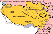
Haibei Tibetan Autonomous Prefecture (Chinese: 海北藏族自治州; Tibetan: མཚོ་བྱང་བོད་རིགས་རང་སྐྱོང་ཁུལ་, Wylie: mtsho-byang bod-rigs rang-skyong-khul, Tib.pin.: cojang poirig ranggyong kü) is an autonomous prefecture of northeastern Qinghai Province, China. The prefecture has an area of 39,354 square kilometres (15,195 sq mi) and its seat is Haiyan County. Its name literally means "north of Qinghai Lake." This Tibetan culture area was incorporated into Qinghai province into Qinghai province in the early 1950s, as opposed to being part of the Tibet Autonomous Region.[1]
Haibei Prefecture
海北州 · མཚོ་བྱང་ཁུལ། | |
|---|---|
Autonomous prefecture | |
| Haibei Tibetan Autonomous Prefecture 海北藏族自治州 · མཚོ་བྱང་བོད་རིགས་རང་སྐྱོང་ཁུལ | |
 | |
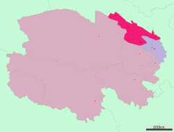 Location of Haibei Prefecture in Qinghai | |
| Country | People's Republic of China |
| Province | Qinghai |
| Prefecture seat | Haiyan County (Xihai) |
| Time zone | UTC+8 (China Standard) |
| ISO 3166 code | CN-QH-22 |
| Haibei Tibetan Autonomous Prefecture | |||||||
|---|---|---|---|---|---|---|---|
| Chinese name | |||||||
| Chinese | 海北藏族自治州 | ||||||
| |||||||
| Tibetan name | |||||||
| Tibetan | མཚོ་བྱང་བོད་རིགས་རང་སྐྱོང་ཁུལ | ||||||
| |||||||
Demographics
According to the 2000 census, Haibei has 258,922 inhabitants with a population density of 6.58 inhabitants/km2.
The following is a list of ethnic groups in the prefecture, 2000 census.
| Ethnicity | Population | Percentage |
|---|---|---|
| Han | 94,841 | 36.63% |
| Hui | 79,190 | 30.58% |
| Tibetan | 62,520 | 24.15% |
| Mongol | 13,087 | 5.05% |
| Tu/Monguor | 7,806 | 3.01% |
| Salar | 901 | 0.35% |
| Others | 577 | 0.23% |
Subdivisions
The prefecture is subdivided into 4 county-level divisions: 3 counties and 1 autonomous county:
| Map | ||||||||
|---|---|---|---|---|---|---|---|---|
| Name | Hanzi | Hanyu Pinyin | Tibetan | Wylie Tibetan Pinyin |
Population (2010 Census) |
Area (km2) | Density (/km2) | |
| Haiyan County | 海晏县 | Hǎiyàn Xiàn | ཧའེ་ཡན་རྫོང་ | ha'e yan rdzong Ha'êyan Zong |
37,788 | 4,348 | 8.69 | |
| Qilian County | 祁连县 | Qílián Xiàn | ཆི་ལེན་རྫོང་ | chi len rdzong Qilên Zong |
46,473 | 15,610 | 2.97 | |
| Gangca County (Gangcha County) |
刚察县 | Gāngchá Xiàn | རྐང་ཚ་རྫོང་ | rkang tsha rdzong Gangca Zong |
41,333 | 12,500 | 3.30 | |
| Menyuan Hui Autonomous County | 门源回族自治县 | Ményuán Huízú Zìzhìxiàn |
མོང་ཡོན་ཧུའེ་རིགས་རང་སྐྱོང་རྫོང་ | mong yon hu'e rigs rang skyong rdzong Mongyoin Hu'êrig Ranggyong Zong |
147,710 | 6,896 | 21.41 | |

References
- Norbu, Dawa (2001-09-27). China's Tibet Policy. Routledge. p. 244. ISBN 978-1-136-79793-4.
External links
Notes: *Provincial capitals, ★Sub-provincial cities, ☆Sub-provincial autonomous prefecture *Sub prefectural-level divisions, ✧"Comparatively larger city" (较大的市) as approved by the State Council | ||||||||||||||||||||||||||||||||||||||||||||||||||||
|  | |||||||||||||||||||||||||||||||||||||||||||||||||||
|
See also: List of prefectures in China, List of cities in China | ||||||||||||||||||||||||||||||||||||||||||||||||||||
Tibetan-designated autonomous areas in China | |||||||||
|---|---|---|---|---|---|---|---|---|---|
| Regions |
|  | |||||||
| Prefectures and counties |
| ||||||||
| |||||||||
На других языках
- [en] Haibei Tibetan Autonomous Prefecture
[ru] Хайбэй-Тибетский автономный округ
Хайбэй-Тибетский автономный округ (кит. упр. 海北藏族自治州, пиньинь Hǎiběi Zàngzú Zìzhìzhōu, тиб. མཚོ་བྱང་བོད་རིགས་རང་སྐྱོང་ཁུལ་, Вайли: Cojang Poirig Ranggyong Kü, тиб. пиньинь: mtsho-byang bod-rigs rang-skyong-khul) — автономный округ в провинции Цинхай, Китай. Площадь — 39,4 тыс. км². Власти автономного округа размещаются в уезде Хайянь. Название «Хайбэй» означает «к северу от озера Кукунор».Другой контент может иметь иную лицензию. Перед использованием материалов сайта WikiSort.org внимательно изучите правила лицензирования конкретных элементов наполнения сайта.
WikiSort.org - проект по пересортировке и дополнению контента Википедии