world.wikisort.org - China
Bairi (Tianzhu) Tibetan Autonomous County (Tibetan: དཔའ་རིས་བོད་རང་སྐྱོང་རྫོང༌།, Wylie: dpa'a-ris bod-rigs rang-skyong rdzong/, ZYPY: Bairi Poirig Ranggyong Zong; Chinese: 天祝藏族自治县; pinyin: Tiānzhù Zàngzú Zìzhìxiàn) is in the prefecture-level city of Wuwei in the central part of Gansu province, China, bordering Qinghai province to the south and west. It has an area of 7,147 km2 (2,759 sq mi) and approximately 230,000 inhabitants (2003). Its administrative seat is the town of Huazangsi.
Bairi County
Tianzhu | |
|---|---|
County | |
| དཔའ་རིས་བོད་རང་སྐྱོང་རྫོང༌། · 天祝藏族自治县 Bairi Tibetan Autonomous County | |
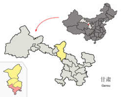 Bairi County (red) within Wuwei City (yellow) and Gansu | |
| Coordinates: 36°58′18″N 103°08′31″E | |
| Country | People's Republic of China |
| Province | Gansu |
| Prefecture-level city | Wuwei |
| Area | |
| • Total | 7,149 km2 (2,760 sq mi) |
| Highest elevation | 4,874 m (15,991 ft) |
| Lowest elevation | 2,040 m (6,690 ft) |
| Population (2018) | |
| • Total | 205,744 |
| • Density | 29/km2 (75/sq mi) |
| Time zone | UTC+8 (China Standard) |
| Postal code | 733200 |
| Website | www |
Name
The Chinese name "Tianzhu" was named by a Tibetan Luo Haoxue in 1936, combining name of the largest lamasery in the County (天堂寺) and the Zhugong lamasery (祝贡寺).[1]
The Tibetan name Bairi (དཔའ་རིས།) is pronounced Bairi in Standard Tibetan, and pronounced Hwari in the local Amdo Tibetan and Huarui (华锐) in Chinese.[2]
An alternative Tibetan name is Tenzhu (ཐེན་ཀྲུའུ།), which is a transcription of the Chinese name Tianzhu.
History
The county was established as the Tianzhu District of Yongdeng County in 1949, but became an autonomous county of Wuwei in the next year. In 1955, Tianzhu was moved under the administration of Zhangye as the first autonomous county in China.[2] Between 1958 and 1961, Gulang County was part of Tianzhu. In 1961 the county was placed under Wuwei again.[3]
Administrative divisions
Tianzhu Tibetan Autonomous County is divided to 14 towns, 5 townships and 2 others.[3][4]
- Towns
|
|
- Townships
|
|
- Others
- Tianzhu Building Material Factory (天祝建材厂)
- Tianzhu Coal and Electricity Company (天祝煤电公司)
Geography
The county is mountainous, being located at the tripoint of the Tibet Plateau, the Loess Plateau and the Inner Mongolia Plateau, with elevations ranging from 2040 m to 4874 m. It is divided into the watersheds of the Shiyang River and the Yellow River and crossed by the Wushao Mountain. South of the Wushao Mountain, the climate is continental and north of it, the climate is semi-arid. The land is mostly covered by grasslands and forests.[3]
Transport
- China National Highway 312
- Lanzhou–Xinjiang Railway crosses the county, with a station (Tianzhu) in the county seat. With the construction of the Wushaoling Tunnel under the Wushao Mountain Range (Wushaoling), about the half of the section of the main track of this railway within this county is actually underground.
Ethnic groups in Tianzhu, 2000 census
| Nationality | Population | Percentage |
|---|---|---|
| Han | 139,190 | 62.88% |
| Tibetan | 66,125 | 29.87% |
| Tu | 12,633 | 5.71% |
| Hui | 1,986 | 0.9% |
| Mongol | 961 | 0.43% |
| Manchu | 213 | 0.1% |
| Dongxiang | 90 | 0.04% |
| Uyghur | 40 | 0.02% |
| Miao | 23 | 0.01% |
| Others | 86 | 0.04% |
References
- "天祝旅游网". Archived from the original on 2013-02-04. Retrieved 2012-01-19.
- "甘肃·天祝 - 走进天祝". www.gstianzhu.gov.cn. Retrieved 2020-12-31.
- "天祝藏族自治县". 13 July 2004.
- "统计用区划代码 www.stats.gov.cn" (in Chinese). XZQH. Retrieved 2020-12-27.
Further reading
- A. Gruschke: The Cultural Monuments of Tibet’s Outer Provinces: Amdo - Volume 2. The Gansu and Sichuan Parts of Amdo, White Lotus Press, Bangkok 2001. ISBN 974-480-049-6
- Tsering Shakya: The Dragon in the Land of Snows. A History of Modern Tibet Since 1947, London 1999, ISBN 0-14-019615-3
Tibetan-designated autonomous areas in China | |||||||||
|---|---|---|---|---|---|---|---|---|---|
| Regions |
|  | |||||||
| Prefectures and counties |
| ||||||||
| |||||||||
Authority control | |
|---|---|
| General | |
| National libraries | |
This Gansu location article is a stub. You can help Wikipedia by expanding it. |
На других языках
- [en] Bairi Tibetan Autonomous County
[ru] Тяньчжу-Тибетский автономный уезд
Тяньчжу́-Тибе́тский автоно́мный уе́зд (кит. упр. 天祝藏族自治县, пиньинь Tiānzhù zàngzú zìzhìxiàn; тиб. ཐེན་ཀྲུའུ་བོད་རིགས་རང་སྐྱོང་ཁུལ, Вайли: then kru bod rigs rang skyong khul) — автономный уезд городского округа Увэй провинции Ганьсу (КНР). Название «Тяньчжу» является аббревиатурой из названий храмов Тяньтансы и Чжугунсы.Другой контент может иметь иную лицензию. Перед использованием материалов сайта WikiSort.org внимательно изучите правила лицензирования конкретных элементов наполнения сайта.
WikiSort.org - проект по пересортировке и дополнению контента Википедии