world.wikisort.org - China
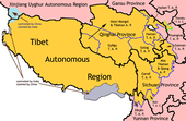
Huangnan Tibetan Autonomous Prefecture (simplified Chinese: 黄南藏族自治州; traditional Chinese: 黃南藏族自治州; pinyin: Huángnán Zàngzú Zìzhìzhōu; Tibetan: རྨ་ལྷོ་བོད་རིགས་རང་སྐྱོང་ཁུལ་, Wylie: rma lho bod rigs rang skyong khul) is an autonomous prefecture of Eastern Qinghai, China, bordering Gansu to the east. The prefecture has area of 17,921 km2 (6,919 sq mi) and its seat is in Tongren County.
This article uses bare URLs, which are uninformative and vulnerable to link rot. (August 2022) |
Huangnan Prefecture
黄南州 · རྨ་ལྷོ་ཁུལ། | |
|---|---|
Autonomous prefecture | |
| Huangnan Tibetan Autonomous Prefecture 黄南藏族自治州 · རྨ་ལྷོ་བོད་རིགས་རང་སྐྱོང་ཁུལ་ | |
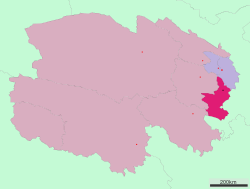 Location of Huangnan Tibetan Autonomous Prefecture in Qinghai | |
| Country | People's Republic of China |
| Province | Qinghai |
| Prefecture seat | Tongren County |
| Time zone | UTC+8 (China Standard) |
| ISO 3166 code | CN-QH-23 |
Demographics
According to the 2000 census, Huangnan has 214,642 inhabitants with a population density of 11.98 inhabitants/km2 (31.03 inhabitants/sq. mi.).
Ethnic groups in Huangnan, 2000 census
| Nationality | Population | Percentage |
|---|---|---|
| Tibetan | 142,360 | 66.32% |
| Mongol | 29,071 | 13.54% |
| Hui | 16,411 | 7.65% |
| Han | 16,194 | 7.54% |
| Tu/Monguor | 8,445 | 3.93% |
| Salar | 1,530 | 0.71% |
| Others | 631 | 0.31% |
Climate
| Climate data for Tongren County (1981–2010) | |||||||||||||
|---|---|---|---|---|---|---|---|---|---|---|---|---|---|
| Month | Jan | Feb | Mar | Apr | May | Jun | Jul | Aug | Sep | Oct | Nov | Dec | Year |
| Record high °C (°F) | 15.1 (59.2) |
21.6 (70.9) |
27.0 (80.6) |
32.7 (90.9) |
30.9 (87.6) |
31.3 (88.3) |
35.0 (95.0) |
34.2 (93.6) |
32.5 (90.5) |
23.4 (74.1) |
19.8 (67.6) |
13.9 (57.0) |
35.0 (95.0) |
| Average high °C (°F) | 1.3 (34.3) |
4.8 (40.6) |
10.1 (50.2) |
15.7 (60.3) |
18.9 (66.0) |
21.3 (70.3) |
23.5 (74.3) |
23.4 (74.1) |
18.7 (65.7) |
13.6 (56.5) |
8.1 (46.6) |
2.7 (36.9) |
13.5 (56.3) |
| Daily mean °C (°F) | −6.6 (20.1) |
−3.2 (26.2) |
2.0 (35.6) |
7.8 (46.0) |
11.9 (53.4) |
14.7 (58.5) |
16.7 (62.1) |
16.1 (61.0) |
12.0 (53.6) |
6.3 (43.3) |
0.1 (32.2) |
−5.1 (22.8) |
6.1 (42.9) |
| Average low °C (°F) | −12.2 (10.0) |
−9.2 (15.4) |
−3.9 (25.0) |
1.4 (34.5) |
5.8 (42.4) |
9.1 (48.4) |
11.2 (52.2) |
10.5 (50.9) |
7.4 (45.3) |
1.4 (34.5) |
−5.4 (22.3) |
−10.6 (12.9) |
0.5 (32.8) |
| Record low °C (°F) | −22.6 (−8.7) |
−19.5 (−3.1) |
−15.0 (5.0) |
−9.3 (15.3) |
−3.7 (25.3) |
1.2 (34.2) |
4.3 (39.7) |
2.3 (36.1) |
−0.9 (30.4) |
−10.5 (13.1) |
−16.4 (2.5) |
−21.5 (−6.7) |
−22.6 (−8.7) |
| Average precipitation mm (inches) | 2.5 (0.10) |
3.9 (0.15) |
11.0 (0.43) |
22.6 (0.89) |
58.0 (2.28) |
64.5 (2.54) |
80.4 (3.17) |
70.8 (2.79) |
65.1 (2.56) |
25.9 (1.02) |
3.1 (0.12) |
0.8 (0.03) |
408.6 (16.08) |
| Source: China Meteorological Administration[1] | |||||||||||||
Subdivisions
The prefecture is subdivided into 4 county-level divisions: 1 county-level city, 2 counties and 1 autonomous county:
| Map | ||||||||
|---|---|---|---|---|---|---|---|---|
| Name | Simplified Chinese | Hanyu Pinyin | Tibetan | Wylie Tibetan Pinyin |
Population (2010 Census) |
Area (km2) | Density (/km2) | |
| Tongren city | 同仁市 | Tóngrén shì | Official: ཐུང་རིན་གྲོང་ཁྱེར། (རེབ་གོང་གྲོང་ཁྱེར། or རེ་སྐོང་གྲོང་ཁྱེར།) |
thung rin grong khyer Tungrin Chongkyêr |
92,601 | 3,465 | 26.72 | |
| Jainca County (Jianzha County) |
尖扎县 | Jiānzhā Xiàn | གཅན་ཚ་རྫོང་། | gcan tsha rdzong Jainca Zong |
55,325 | 1,712 | 32.31 | |
| Zêkog County (Zeku County) |
泽库县 | Zékù Xiàn | རྩེ་ཁོག་རྫོང་། | rtse khog rdzong Zêkog Zong |
69,416 | 6,494 | 10.68 | |
| Henan Mongol Autonomous County |
河南蒙古族 自治县 |
Hénán Měnggǔzú Zìzhìxiàn |
རྨ་ལྷོ་སོག་རིགས་རང་སྐྱོང་རྫོང་། | rma lho sog rigs rang skyong rdzong Malho Sogrig Ranggyong Zong |
39,374 | 6,250 | 6.29 | |

Rongwo Monastery
Huangnan is home to Rongwo Monastery, a Gelug monastery initially established in 1341 in Amdo on the Rongwo River.[2][3]
Further reading
- A. Gruschke: The Cultural Monuments of Tibet’s Outer Provinces: Amdo - Volume 1. The Qinghai Part of Amdo, White Lotus Press, Bangkok 2001. ISBN 974-480-049-6
- Tsering Shakya: The Dragon in the Land of Snows. A History of Modern Tibet Since 1947, London 1999, ISBN 0-14-019615-3
Notes: *Provincial capitals, ★Sub-provincial cities, ☆Sub-provincial autonomous prefecture *Sub prefectural-level divisions, ✧"Comparatively larger city" (较大的市) as approved by the State Council | ||||||||||||||||||||||||||||||||||||||||||||||||||||||||||||||||
|  | |||||||||||||||||||||||||||||||||||||||||||||||||||||||||||||||
|
See also: List of prefectures in China, List of cities in China | ||||||||||||||||||||||||||||||||||||||||||||||||||||||||||||||||
Tibetan-designated autonomous areas in China | |||||||||
|---|---|---|---|---|---|---|---|---|---|
| Regions |
|  | |||||||
| Prefectures and counties |
| ||||||||
| |||||||||
References
- 中国地面国际交换站气候标准值月值数据集(1981-2010年) (in Simplified Chinese). China Meteorological Administration. Retrieved January 1, 2011.
- http://www.baronet4tibet.com/sange_shong_info/rongwu.html
- Staff (6 February 2008). "Longwu Temple - garden of Tibetan Buddhism and Western Region". China Tour Guide. Archived from the original on 14 February 2010. Retrieved 2010-02-04.
На других языках
- [en] Huangnan Tibetan Autonomous Prefecture
[ru] Хуаннань-Тибетский автономный округ
Хуаннань-Тибетский автономный округ (кит. упр. 黄南藏族自治州, пиньинь Huángnán Zàngzú Zìzhìzhōu, тиб. རྨ་ལྷོ་བོད་རིགས་རང་སྐྱོང་ཁུལ་, Вайли: rma lho bod rigs rang skyong khul) — автономный округ в провинции Цинхай, Китай. Слово «Хуаннань» в переводе с китайского языка означает «к югу от Хуанхэ».Другой контент может иметь иную лицензию. Перед использованием материалов сайта WikiSort.org внимательно изучите правила лицензирования конкретных элементов наполнения сайта.
WikiSort.org - проект по пересортировке и дополнению контента Википедии