world.wikisort.org - China
Yangjiang (Chinese: 阳江, yang-CH'YANG), alternately romanized as Yeungkong,[lower-alpha 1] is a prefecture-level city in southwestern Guangdong Province in the People's Republic of China. It borders Maoming to the west, Yunfu to the north, Jiangmen to the east, and looks out to the South China Sea to the south. The local dialect is the Gaoyang dialect, a branch of Yue Chinese. During the 2020 census, its population was 2,602,959 inhabitants of whom 1,292,987 lived in the built-up (or metro) and largely urbanized area comprising Jiangcheng District and Yangdong County.[4]
Yangjiang
阳江 | |
|---|---|
Prefecture-level city | |
 Hailing Island in Yangjiang | |
 | |
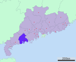 Location of Yangjiang City jurisdiction in Guangdong | |
 Yangjiang Location in China | |
| Coordinates (Yangjiang municipal government): 21°51′25″N 111°58′59″E | |
| Country | People's Republic of China |
| Province | Guangdong |
| County-level divisions | 4 |
| Municipal seat | Jiangcheng District |
| Government | |
| Area | |
| • Prefecture-level city | 7,955.27 km2 (3,071.55 sq mi) |
| • Urban | 2,482.5 km2 (958.5 sq mi) |
| • Metro | 2,482.5 km2 (958.5 sq mi) |
| Elevation | 4 m (13 ft) |
| Population (2020 census[1]) | |
| • Prefecture-level city | 2,602,959 |
| • Density | 330/km2 (850/sq mi) |
| • Urban | 1,292,987 |
| • Urban density | 520/km2 (1,300/sq mi) |
| • Metro | 1,292,987 |
| • Metro density | 520/km2 (1,300/sq mi) |
| Time zone | UTC+8 (China Standard) |
| Postal code | 529500
(Urban center) 529600, 529800, 529900 (Other areas) |
| Area code | 0662 |
| ISO 3166 code | CN-GD-17 |
| GDP | ¥27.39 billion (2004) |
| GDP per capita | ¥10,493 (2004) |
| License Plate | 粤Q |
| Major Nationalities | Han |
| Yangjiang | |||||||||||||||||||||
|---|---|---|---|---|---|---|---|---|---|---|---|---|---|---|---|---|---|---|---|---|---|
 "Yangjiang", as written in Chinese calligraphy | |||||||||||||||||||||
| Simplified Chinese | 阳江 | ||||||||||||||||||||
| Traditional Chinese | 陽江 | ||||||||||||||||||||
| Hanyu Pinyin | Yángjiāng | ||||||||||||||||||||
| Cantonese Yale | Yèuhnggōng | ||||||||||||||||||||
| Postal | Yeungkong | ||||||||||||||||||||
| Literal meaning | Sunny River Yang River | ||||||||||||||||||||
| |||||||||||||||||||||
History
Under the Qing, Yangjiang County made up part of the commandery of Zhaoqing.[5] It was later split off as a separate prefecture in its own right.
Administration
The prefecture-level city of Yangjiang administers 4 county-level divisions, including 2 districts, 1 county-level city and 1 counties.
| Map | |||||
|---|---|---|---|---|---|
| Name | Simplified Chinese | Hanyu Pinyin | Population (2010 census) |
Area (km2) |
Density (/km2) |
| Jiangcheng District | 江城区 | Jiāngchéng Qū | 676,857 | 779,69 | 868 |
| Yangdong District | 阳东区 | Yángdōng Qū | 442,762 | 1,702.8 | 260 |
| Yangxi County | 阳西县 | Yángxī Xiàn | 452,625 | 1,435 | 315 |
| Yangchun | 阳春市 | Yángchūn Shì | 849,505 | 4,037.8 | 210 |

Yangjiang is located, 2:30 hours from Guangzhou by bus. Notable areas include the Zhapo Beach and Hailing Island near Shapa Town.
Economy and culture
Yangjiang is the base of Yangjiang Shibazi, a knife manufacturer.
The Yangjiang Group artist collective is based in the city, and its members' work is largely inspired by the locality.
Yangjiang is home to six nuclear reactors, the largest nuclear power station in China.
Geography

The city is named for the Moyang River.
The city was hit by a magnitude 5.9 earthquake on July 25, 1969 which killed over 3,000 people. The area is known for its relatively high levels of natural background radiation.[6]
Climate
Yangjiang has a monsoon-influenced humid subtropical climate (Köppen Cwa), with mild to warm winters and long, hot (but not especially so) summers, and very humid conditions year-round. Winter begins sunny and dry but becomes progressively wetter and cloudier. Spring is generally overcast, while summer brings the heaviest rains of the year though is much sunnier; there are 12.6 days with 50 mm (1.97 in) or more rainfall. Autumn is sunny and dry. The monthly 24-hour average temperature ranges from 15.5 °C (59.9 °F) in January to 28.3 °C (82.9 °F) in July, and the annual mean is 22.74 °C (72.9 °F). The annual rainfall is around 2,221 mm (87 in), close to two-thirds of which occurs from May to August. With monthly percent possible sunshine ranging from 18% in March to 55% in October, the city receives 1,757 hours of bright sunshine annually.
| Climate data for Yangjiang (1981−2010 normals) | |||||||||||||
|---|---|---|---|---|---|---|---|---|---|---|---|---|---|
| Month | Jan | Feb | Mar | Apr | May | Jun | Jul | Aug | Sep | Oct | Nov | Dec | Year |
| Record high °C (°F) | 28.0 (82.4) |
28.9 (84.0) |
32.2 (90.0) |
31.7 (89.1) |
33.9 (93.0) |
36.8 (98.2) |
36.6 (97.9) |
37.5 (99.5) |
36.8 (98.2) |
33.4 (92.1) |
33.1 (91.6) |
29.2 (84.6) |
37.5 (99.5) |
| Average high °C (°F) | 19.9 (67.8) |
19.5 (67.1) |
22.2 (72.0) |
25.9 (78.6) |
29.1 (84.4) |
30.8 (87.4) |
31.6 (88.9) |
31.9 (89.4) |
30.9 (87.6) |
28.8 (83.8) |
25.2 (77.4) |
21.4 (70.5) |
26.4 (79.6) |
| Daily mean °C (°F) | 15.5 (59.9) |
16.0 (60.8) |
19.0 (66.2) |
22.9 (73.2) |
26.0 (78.8) |
27.8 (82.0) |
28.3 (82.9) |
28.2 (82.8) |
27.1 (80.8) |
24.7 (76.5) |
20.7 (69.3) |
16.7 (62.1) |
22.7 (72.9) |
| Average low °C (°F) | 12.2 (54.0) |
13.5 (56.3) |
16.7 (62.1) |
20.7 (69.3) |
23.5 (74.3) |
25.3 (77.5) |
25.6 (78.1) |
25.4 (77.7) |
24.2 (75.6) |
21.5 (70.7) |
17.1 (62.8) |
13.1 (55.6) |
19.9 (67.8) |
| Record low °C (°F) | 2.9 (37.2) |
3.8 (38.8) |
4.7 (40.5) |
9.9 (49.8) |
15.3 (59.5) |
19.3 (66.7) |
21.1 (70.0) |
21.3 (70.3) |
16.8 (62.2) |
12.0 (53.6) |
6.2 (43.2) |
3.4 (38.1) |
2.9 (37.2) |
| Average precipitation mm (inches) | 31.3 (1.23) |
71.6 (2.82) |
83.6 (3.29) |
202.6 (7.98) |
344.4 (13.56) |
374.8 (14.76) |
322.7 (12.70) |
374.5 (14.74) |
253.0 (9.96) |
86.9 (3.42) |
46.8 (1.84) |
28.8 (1.13) |
2,221 (87.43) |
| Average precipitation days (≥ 0.1 mm) | 4.4 | 4.6 | 5.5 | 6.8 | 12.2 | 17.4 | 20.3 | 19.3 | 15.8 | 13.0 | 7.3 | 3.8 | 130.4 |
| Average relative humidity (%) | 73 | 81 | 85 | 86 | 85 | 85 | 84 | 84 | 80 | 74 | 69 | 67 | 79 |
| Mean monthly sunshine hours | 127.6 | 73.4 | 65.7 | 79.7 | 132.5 | 159.2 | 211.4 | 180.0 | 180.2 | 198.8 | 179.3 | 169.1 | 1,756.9 |
| Percent possible sunshine | 38 | 23 | 18 | 21 | 33 | 40 | 51 | 45 | 49 | 55 | 54 | 51 | 40 |
| Source: China Meteorological Administration (precipitation days and sunshine 1971–2000)[7][8] | |||||||||||||
Notes
References
Citations
- "China: Guăngdōng (Prefectures, Cities, Districts and Counties) - Population Statistics, Charts and Map".
- Baynes, T. S., ed. (1878), , Encyclopædia Britannica, vol. 5 (9th ed.), New York: Charles Scribner's Sons
- Chisholm, Hugh, ed. (1911). . Encyclopædia Britannica. Vol. XV (11th ed.). Cambridge University Press.
- "China: Guăngdōng (Prefectures, Cities, Districts and Counties) - Population Statistics, Charts and Map".
- Bolton & al. (1941), p. 262.
- Zhang, SP (2010). "Mechanism study of adaptive response in high background radiation area of Yangjiang in China". Chinese Journal of Preventive Medicine. 44 (9): 815–819. PMID 21092626.
- 中国气象数据网 - WeatherBk Data (in Chinese (China)). China Meteorological Administration. Retrieved 2020-04-15.
- 中国地面国际交换站气候标准值月值数据集(1971-2000年). China Meteorological Administration. Archived from the original on 2013-09-21. Retrieved 2010-05-25.
Bibliography
- Bolton, Kingsley; et al. (1941), Triad Societies, Vol. 5, Abingdon: Routledge, ISBN 9780415243971, reprinted 2000.
External links
- Government website of Yangjiang (in Chinese and English)
- Official Yangjiang Travel Site (in English)
| |||||||||||||||||||||||||||||||||||||||||||||||||||||||||||||||||||||||||||||||||||||||||||||||||||||||||||||||||||||||||||||||||||||||||||||||||||||||||||||||||||||||||||||||||||||||||||||||


Authority control | |
|---|---|
| General | |
| National libraries | |
| Other |
|
На других языках
[de] Yangjiang
Yangjiang (chinesisch .mw-parser-output .Hani{font-size:110%}阳江市, Pinyin Yángjiāng Shì) ist eine bezirksfreie Stadt an der chinesischen Südküste in der Provinz Guangdong.- [en] Yangjiang
[ru] Янцзян
Янцзя́н (иер. трад. 陽江, упр. 阳江, ютпхин: Joeng⁴gong¹, пиньинь: Yángjiāng) — городской округ в провинции Гуандун КНР.Другой контент может иметь иную лицензию. Перед использованием материалов сайта WikiSort.org внимательно изучите правила лицензирования конкретных элементов наполнения сайта.
WikiSort.org - проект по пересортировке и дополнению контента Википедии