world.wikisort.org - China
Chamdo, officially Qamdo[2][3] (Tibetan: ཆབ་མདོ, Wylie: chab mdo, ZYPY: qamdo) and also known in Chinese as Changdu[4], is a prefecture-level city in the eastern part of the Tibet Autonomous Region, China. Its seat is the town of Chengguan in Karuo District. Chamdo is Tibet's third largest city after Lhasa and Shigatse.[5]
This article may be expanded with text translated from the corresponding article in Chinese. (June 2020) Click [show] for important translation instructions.
|
Qamdo
昌都市 ཆབ་མདོ་གྲོང་ཁྱེར། | |
|---|---|
Prefecture-level city | |
 Mekong River to the south of Chamdo Town | |
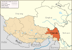
 prefecture (orange) in Tibet Autonomous Region (light-orange) | |
| Coordinates (Qamdo municipal government): 31°08′35″N 97°10′12″E | |
| Country | People's Republic of China |
| Autonomous region | Tibet |
| County-level divisions |
|
| Prefecture seat | Karub District (Chengguan) |
| Area | |
| • Total | 110,154 km2 (42,531 sq mi) |
| Elevation | 3,240 m (10,630 ft) |
| Population (2019) | |
| • Total | 798,067 |
| • Density | 7.2/km2 (19/sq mi) |
| Time zone | UTC+8 (China Standard) |
| ISO 3166 code | CN-XZ-03 |
| GDP (Nominal)[1] | 2021 |
| - Total | ¥27.9 billion $4.33 billion |
| - Per Capita | ¥36,574 $5,668 |
| - Growth | |
| Qamdo | |||||||
|---|---|---|---|---|---|---|---|
 "Qamdo" in Chinese characters | |||||||
| Chinese name | |||||||
| Chinese | 昌都 | ||||||
| |||||||
| Tibetan name | |||||||
| Tibetan | ཆབ་མདོ། | ||||||
| |||||||
Chamdo is divided into 11 county-level divisions: one district and ten counties. The main district is Karuo District. Other counties include Jonda County, Gonjo County, Riwoche County, Dengqen County, Zhag'yab County, Baxoi County, Zognang County, Maarkam County, Lhorong County, and Banbar County.
History
On 11 July 2014 Chamdo Prefecture was upgraded into a prefecture-level city.[6]
Languages
Languages spoken in Chamdo include Khams Tibetan and the Chamdo languages of Lamo, Larong, and Drag-yab.[7]
Transportation
Air
Qamdo Bamda Airport, opened in 1994, is located 126 kilometres (78 miles) from Chengguan Town in Karub District. The long commute (2.5 hours by mountain road) is the result of no flat land closer to the city being available to construct an airport.
Road
China National Highway 214 and China National Highway 317 are the main roads in and out of Chamdo.
Subdivisions

The city is subdivided into 11 county-level divisions: 1 district and 10 counties
| Map | ||||||||
|---|---|---|---|---|---|---|---|---|
| Name | Hanzi | Hanyu Pinyin | Tibetan | Wylie | Population (2010 Census) | Area (km²) | Density (/km²) | |
| Karuo District | 卡若区 | Kǎruò Qū | མཁར་རོ་ཆུས། | mkhar ro chus | 116,500 | 10,794 | 10.79 | |
| Jomda County | 江达县 | Jiāngdá Xiàn | འཇོ་མདའ་རྫོང་། | 'jo mda' rdzong | 76,026 | 13,164 | 5.77 | |
| Gonjo County | 贡觉县 | Gòngjué Xiàn | གོ་འཇོ་རྫོང་། | go 'jo rdzong | 40,434 | 6,323 | 6.39 | |
| Riwoqê County | 类乌齐县 | Lèiwūqí Xiàn | རི་བོ་ཆེ་རྫོང་། | ri bo che rdzong | 49,870 | 6,355 | 7.84 | |
| Dêngqên County | 丁青县 | Dīngqīng Xiàn | སྟེང་ཆེན་རྫོང་། | steng chen rdzong | 69,888 | 12,408 | 5.63 | |
| Zhag'yab County | 察雅县 | Cháyǎ Xiàn | བྲག་གཡབ་རྫོང་། | brag g-yab rdzong | 56,789 | 8,251 | 6.88 | |
| Baxoi County | 八宿县 | Bāsù Xiàn | དཔའ་ཤོད་རྫོང་། | dpa' shod rdzong | 39,021 | 12,336 | 3.16 | |
| Zogang County | 左贡县 | Zuǒgòng Xiàn | མཛོ་སྒང་རྫོང་། | mdzo sgang rdzong | 44,320 | 11,837 | 3.74 | |
| Markam County | 芒康县 | Mángkāng Xiàn | སྨར་ཁམས་རྫོང་། | smar khams rdzong | 81,399 | 11,576 | 7.03 | |
| Lhorong County | 洛隆县 | Luòlóng Xiàn | ལྷོ་རོང་རྫོང་། | lho rong rdzong | 47,491 | 8,048 | 5.90 | |
| Banbar County | 边坝县 | Biānbà Xiàn | དཔལ་འབར་རྫོང་། | dpal 'bar rdzong | 35,767 | 8,774 | 4.07 | |

Climate
Chamdo has a humid continental climate (Köppen: Dwb) in the Karub District and an alpine subarctic climate (Köppen: Dwc) in other counties.
| Climate data for Karub District, Chamdo (1981–2010 normals) | |||||||||||||
|---|---|---|---|---|---|---|---|---|---|---|---|---|---|
| Month | Jan | Feb | Mar | Apr | May | Jun | Jul | Aug | Sep | Oct | Nov | Dec | Year |
| Record high °C (°F) | 21.8 (71.2) |
21.4 (70.5) |
26.1 (79.0) |
28.1 (82.6) |
29.5 (85.1) |
32.7 (90.9) |
32.0 (89.6) |
30.8 (87.4) |
30.5 (86.9) |
27.7 (81.9) |
22.3 (72.1) |
20.2 (68.4) |
32.7 (90.9) |
| Average high °C (°F) | 8.7 (47.7) |
10.2 (50.4) |
13.3 (55.9) |
16.6 (61.9) |
20.9 (69.6) |
23.6 (74.5) |
24.2 (75.6) |
23.5 (74.3) |
21.6 (70.9) |
17.6 (63.7) |
12.7 (54.9) |
9.5 (49.1) |
16.9 (62.4) |
| Daily mean °C (°F) | −1.6 (29.1) |
1.0 (33.8) |
4.7 (40.5) |
8.1 (46.6) |
12.2 (54.0) |
15.3 (59.5) |
16.3 (61.3) |
15.5 (59.9) |
13.1 (55.6) |
8.4 (47.1) |
2.4 (36.3) |
−1.5 (29.3) |
7.8 (46.1) |
| Average low °C (°F) | −9.6 (14.7) |
−6.8 (19.8) |
−2.4 (27.7) |
1.4 (34.5) |
5.3 (41.5) |
9.2 (48.6) |
10.6 (51.1) |
10.0 (50.0) |
7.3 (45.1) |
1.8 (35.2) |
−5.0 (23.0) |
−9.3 (15.3) |
1.0 (33.9) |
| Record low °C (°F) | −19.4 (−2.9) |
−17.4 (0.7) |
−13.0 (8.6) |
−7.7 (18.1) |
−4.0 (24.8) |
1.1 (34.0) |
2.9 (37.2) |
1.1 (34.0) |
−0.9 (30.4) |
−7.0 (19.4) |
−13.6 (7.5) |
−20.7 (−5.3) |
−20.7 (−5.3) |
| Average precipitation mm (inches) | 1.2 (0.05) |
3.3 (0.13) |
11.3 (0.44) |
24.4 (0.96) |
39.3 (1.55) |
85.9 (3.38) |
106.5 (4.19) |
100.5 (3.96) |
74.6 (2.94) |
34.6 (1.36) |
5.7 (0.22) |
2.0 (0.08) |
489.3 (19.26) |
| Average relative humidity (%) | 36 | 36 | 41 | 48 | 50 | 59 | 65 | 67 | 67 | 59 | 46 | 39 | 51 |
| Source: China Meteorological Administration,[8] | |||||||||||||
References
- "2021年昌都市国民经济和社会发展统计公报" (in Chinese). 11 May 2022. Retrieved 12 May 2021.
{{cite web}}: CS1 maint: url-status (link) - 国家测绘局地名研究所 [National Surveying Bureau Place Names Research Institute] (1997). 中国地名录 [Gazetteer of China]. Beijing: SinoMaps Press. p. 27. ISBN 7-5031-1718-4.
- "New city to be established in China's Tibet". The State Council of the People's Republic of China. Xinhua. Archived from the original on 27 July 2018. Retrieved 9 August 2017.
- Powers, John (2016). "Appendix B". The Buddha Party: How the People's Republic of China Works to Define and Control Tibetan Buddhism (1st ed.). New York: Oxford University Press. ISBN 9780199358151.
PINYIN= Changdu Zhen
- Buckley and Straus 1986, p. 215.
- Yang, Shoude. 西藏东部昌都地区将撤地设市 已获国务院批复. Xinhua Qinghai (in Chinese (China)). Archived from the original on 6 November 2014. Retrieved 5 November 2014.
- Tashi Nyima; Hiroyuki Suzuki (2019). "Newly recognised languages in Chamdo: Geography, culture, history, and language". Linguistics of the Tibeto-Burman Area. 42 (1): 38–81. doi:10.1075/ltba.18004.nyi. ISSN 0731-3500.
- 中国地面国际交换站气候标准值月值数据集(1981-2010年) (in Chinese (China)). China Meteorological Administration. Retrieved January 1, 2011.
External links
| County-level divisions |
|  | ||||
|---|---|---|---|---|---|---|
| Settlements | ||||||
Notes: *Provincial capitals, ★Sub-provincial cities, ☆Sub-provincial autonomous prefecture *Sub prefectural-level divisions, ✧"Comparatively larger city" (较大的市) as approved by the State Council | ||||||||||||||||||||||||||||||||||||||||||||||||||||
|  | |||||||||||||||||||||||||||||||||||||||||||||||||||
|
See also: List of prefectures in China, List of cities in China | ||||||||||||||||||||||||||||||||||||||||||||||||||||
| Authority control |
|
|---|
На других языках
- [en] Chamdo
[ru] Чамдо
Чамдо (тиб. ཆབ་མདོ་ས་ཁུལ་, кит. упр. 昌都, пиньинь Chāngdū) — городской округ в Тибетском автономном районе КНР. Название в переводе с тибетского языка означает «устья двух рек» (в этих местах Эмчу впадает в Меконг).Другой контент может иметь иную лицензию. Перед использованием материалов сайта WikiSort.org внимательно изучите правила лицензирования конкретных элементов наполнения сайта.
WikiSort.org - проект по пересортировке и дополнению контента Википедии