world.wikisort.org - Japan
Kitakyushu (Japanese: 北九州市, Hepburn: Kitakyūshū-shi) is a city located in Fukuoka Prefecture, Japan. As of June 1, 2019, Kitakyushu has an estimated population of 940,978, making it the second-largest city in both Fukuoka Prefecture and the island of Kyushu after the city of Fukuoka. It is one of Japan's 20 designated cities, one of three on Kyushu, and is divided into seven wards.
This article may be expanded with text translated from the corresponding article in Japanese. (December 2016) Click [show] for important translation instructions.
|
Kitakyushu
北九州市 | |
|---|---|
Designated city | |
| City of Kitakyushu[1] | |
 Clockwise from top: the Riverwalk shopping center; Kokura Castle; Mojiko Station; the former Higashida blast furnace; a night view of Kokura from Mount Adachi; the Tanga Market in Kokura | |
 Flag  Emblem | |
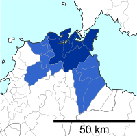
 Location of Kitakyushu in Fukuoka Prefecture | |
 | |
 Kitakyushu Location in Japan | |
| Coordinates: 33°53′N 130°53′E | |
| Country | Japan |
| Region | Kyushu |
| Prefecture | Fukuoka Prefecture |
| Government | |
| • Mayor | Kenji Kitahashi |
| Area | |
| • Total | 491.95 km2 (189.94 sq mi) |
| Population (June 1, 2019) | |
| • Total | 940,978 |
| • Density | 1,900/km2 (5,000/sq mi) |
| Time zone | UTC+09:00 (JST) |
| City hall address | 1-1 Jōnai, Kokura Kita-ku, Kitakyushu-shi, Fukuoka-ken 803-8501 |
| Climate | Cfa |
| Website | www |
| Symbols | |
| Flower | Tsutsuji (Azalea) Himawari (Sunflower) |
| Tree | Ichiigashi (Japanese beech) |
Kitakyushu was formed in 1963 from a merger of municipalities centered on the historic city of Kokura, and its name literally means "North Kyushu City" in Japanese. It is located at the northernmost point of Kyushu on the Kanmon Straits, separating the island from Honshu, across from the city of Shimonoseki. Kitakyushu and Shimonoseki are connected by numerous transport links including the Kanmon Bridge and the Kanmon Tunnels. Kitakyushu's Urban Employment Area forms part of the Fukuoka-Kitakyushu Greater Metropolitan Region, which, with a population of 5,738,977 (2005-2006), is the largest metropolitan area in Japan west of the Keihanshin region.
History
Kokura Prefecture
Kokura Prefecture was founded separately from Fukuoka Prefecture in 1871 when the clan system was abolished. The old wooden-built Kokura Prefectural Office is still standing and is being restored. It is opposite Riverwalk Kitakyūshū. In 1876, Kokura Prefecture was absorbed by Fukuoka Prefecture. The city of Kokura was founded in 1900.
World War II
Yahata in Kitakyushu was the target for the beginning of the US bombing raids on the home islands on June 16, 1944, when 75 Boeing B-29 Superfortresses flew out from mainland China.[2]
Kokura was the primary target of the nuclear weapon "Fat Man" on August 9, 1945. Major Charles Sweeney had orders to drop the bomb visually. All three attempts failed due to clouds and smoke from Yahata, which is only 7 km west of Kokura and had air raids on the previous day, preventing him from identifying the target clearly. Additionally, a smoke screen was created by industrial workers burning barrels of coal tar and/or electric plant workers releasing steam.[3][4] The bomb was ultimately dropped on the city of Nagasaki, the secondary target, at 11:02 JST.
City
The city of Kitakyushu was founded on February 10, 1963, and was designated on April 1, 1963, by government ordinance. The city was born from the merger of five municipalities (Moji, Kokura, Tobata, Yahata and Wakamatsu) centered around the ancient feudal city of Kokura. The city's symbol mark is a flower with the character "north" (北, kita) in the middle and five petals representing the towns that merged.
Geography and administrative divisions
Demographics
As of 1 October 2018[update], the city had an estimated population of 945,595 and a total area of 491.95 km2 (189.94 sq mi).[5] The average population density is 1,922 persons /km2 (4,980/sq mi). It is now the country's 15th most populated city.[5] It has a much larger total area than that of Fukuoka which is only 343.39 km2 (132.58 sq mi).[5]
Wards
Kitakyushu has seven wards (ku):
| Wards of Kitakyushu | |||||
|---|---|---|---|---|---|
| Place Name | Map of Kitakyushu | ||||
| Rōmaji | Kanji | Color | Land area in km2 | ||
| 1 | Kokurakita-ku (administrative center) |
小倉北区 | 39.27 |  | |
| 2 | Kokuraminami-ku | 小倉南区 | 170.25 | ||
| 3 | Moji-ku | 門司区 | 73.37 | ||
| 4 | Tobata-ku | 戸畑区 | 16.66 | ||
| 5 | Yahatahigashi-ku | 八幡東区 | 36.36 | ||
| 6 | Yahatanishi-ku | 八幡西区 | 83.04 | ||
| 7 | Wakamatsu-ku | 若松区 | 67.86 | ||
The city of Nakama, Fukuoka was to become the eighth ward of Kitakyushu in 2005 (to be called Nakama-ku). However, the merger was rejected on December 24, 2004 by Nakama's city council, despite having been initiated by Nakama City.
Cityscape
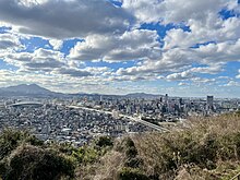 Skyline of Kokura(2021)
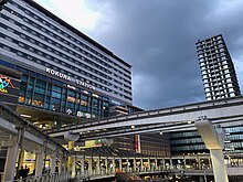 Kokura Station(2021)
 West Japan Industrial Club(2020)
 Port of Kitakyushu(2014)
 Downtown of Kokura(2014)
 Wakato Bridge(2008)


Climate
| Climate data for Yahatañishi-ku, Kitakyushu (1991−2020 normals, extremes 1977−present) | |||||||||||||
|---|---|---|---|---|---|---|---|---|---|---|---|---|---|
| Month | Jan | Feb | Mar | Apr | May | Jun | Jul | Aug | Sep | Oct | Nov | Dec | Year |
| Record high °C (°F) | 19.0 (66.2) |
24.0 (75.2) |
25.2 (77.4) |
30.1 (86.2) |
32.4 (90.3) |
34.2 (93.6) |
36.9 (98.4) |
36.7 (98.1) |
34.5 (94.1) |
33.0 (91.4) |
26.4 (79.5) |
24.8 (76.6) |
36.9 (98.4) |
| Average high °C (°F) | 9.8 (49.6) |
10.9 (51.6) |
14.4 (57.9) |
19.6 (67.3) |
24.2 (75.6) |
27.0 (80.6) |
30.7 (87.3) |
31.9 (89.4) |
28.1 (82.6) |
23.2 (73.8) |
17.7 (63.9) |
12.2 (54.0) |
20.8 (69.5) |
| Daily mean °C (°F) | 6.2 (43.2) |
6.9 (44.4) |
10.0 (50.0) |
14.7 (58.5) |
19.3 (66.7) |
22.7 (72.9) |
26.8 (80.2) |
27.8 (82.0) |
24.0 (75.2) |
18.8 (65.8) |
13.3 (55.9) |
8.3 (46.9) |
16.6 (61.8) |
| Average low °C (°F) | 2.8 (37.0) |
3.2 (37.8) |
5.9 (42.6) |
10.2 (50.4) |
14.9 (58.8) |
19.3 (66.7) |
23.7 (74.7) |
24.6 (76.3) |
20.6 (69.1) |
14.8 (58.6) |
9.3 (48.7) |
4.7 (40.5) |
12.8 (55.1) |
| Record low °C (°F) | −4.6 (23.7) |
−6.2 (20.8) |
−3.8 (25.2) |
0.5 (32.9) |
6.4 (43.5) |
10.5 (50.9) |
15.4 (59.7) |
17.6 (63.7) |
8.9 (48.0) |
3.5 (38.3) |
0.7 (33.3) |
−3.6 (25.5) |
−6.2 (20.8) |
| Average precipitation mm (inches) | 87.9 (3.46) |
79.2 (3.12) |
114.2 (4.50) |
125.4 (4.94) |
142.9 (5.63) |
239.5 (9.43) |
314.6 (12.39) |
198.1 (7.80) |
165.9 (6.53) |
85.2 (3.35) |
91.8 (3.61) |
75.9 (2.99) |
1,720.5 (67.74) |
| Average precipitation days (≥ 1.0 mm) | 10.8 | 10.4 | 10.9 | 10.0 | 9.0 | 12.3 | 11.8 | 10.0 | 9.7 | 7.3 | 9.4 | 9.8 | 121.4 |
| Mean monthly sunshine hours | 101.8 | 113.2 | 159.5 | 188.6 | 205.0 | 139.2 | 167.6 | 196.2 | 159.8 | 170.5 | 131.5 | 102.9 | 1,835.7 |
| Source: Japan Meteorological Agency[6][7] | |||||||||||||
Economy
This section needs additional citations for verification. (May 2009) |


Nippon Steel Corporation is a major employer, but the Yahata and Tobata plants are much reduced from their heyday of the 1960s. The Zenrin company known for its mapping and navigation software is based here[8] and so is Toto Ltd.[9] and Yaskawa Electric Corporation.[10] StarFlyer, an airline, is headquartered on the grounds of Kitakyushu Airport in Kokuraminami-ku, Kitakyūshū.[11] Previously the airline's headquarters were in the Shin Kokura Building (新小倉ビル, Shin-Kokura Biru) in Kokurakita-ku, Kitakyūshū.[12][13]
A smaller scale shopping center known as Cha Cha Town, next to the Sunatsu bus depot in Kokura Kita ward, was created by the Nishi-Nippon Railroad and bus company.
In 2009 Bridgestone Corporation opened a plant in Kitakyushu to produce large and ultralarge off-the-road radial tires for construction and mining vehicles.
The GDP in Greater Kitakyushu, Kitakyushu Metropolitan Employment Area was US$55.7 billion in 2010.[14][15]
Education

Universities and colleges
National universities
- Kyushu Institute of Technology
Public universities
- Kyushu Dental University
- University of Kitakyushu
Private universities
- Kyushu International University
- Kyushu Kyoritsu University
- Kyushu Nutrition Welfare University
- Kyushu Polytechnic College
- Kyushu Women's University
- Nishinippon Institute of Technology
- Seinan Women's University
- University of Occupational and Environmental Health
Junior colleges
- Higashi Chikushi Junior College
- Kyushu Women's Junior College
- Orio Aishin Junior College
- Seinan Jo Gakuin University Junior College
Technology colleges
- Kitakyushu National College of Technology
Vocational colleges
- Kyushu Medical Sports School
Research Institutes and graduate Schools
- Kitakyushu Science and Research Park
- Graduate School of International Environmental Engineering, The University of Kitakyushu
- Fukuoka University Institute for Recycling and Environmental Control Systems
- Graduate School of Life Science and Systems Engineering, Kyushu Institute of Technology
- Graduate School of Information, Production and Systems/Information, Production and Systems Research Center, Waseda University
Transportation


Located at a strategic position on the south side of the Kanmon Straits, Kitakyushu is an important transport hub for traffic between Honshu and Kyushu and has a large port.
Air
Airport
The Kitakyushu Airport opened on March 16, 2006. It is larger than the previous Kokura Airport and supports 24-hour operations thanks to its location on an artificial island in the Seto Inland Sea. It will eventually be connected with Kokura Station by a new fast rail link. A new airline based in the city called StarFlyer began operations when the airport opened.
Railways
Kokura Station, the city's central train station, is the penultimate stop on the JR West Sanyō Shinkansen before the Fukuoka terminus and all Shinkansen services stop here. It is served by local and express trains on JR Kyushu's Kagoshima and Nippō Main Lines. In the city, transport is provided the Kitakyushu Monorail and buses.
Mojikō Station in Moji-ku is the northern terminus of the Kagoshima Main Line, the most important line in the JR Kyushu network.
A tram network operated by the Nishi-Nippon Railroad known as the Kitakyushu Line once operated in the city; after dwindling passenger numbers in the 1970s the line was shut down in stages between 1980 and 2000. A railway using tram cars, the Chikuhō Electric Railroad, runs between Kurosaki-Ekimae and Chikuhō-Nōgata stations, serving Yahatanishi-ku and the neighboring city of Nōgata.
Roads
Expressways
The metropolitan area of Kitakyushu is covered by the Kitakyushu Expressway, which has five routes serving the city, totaling 53 kilometers of four-lane expressways. Some of these expressways are elevated, especially around the city center. Route 1 serves the city center, while route 2 serves the port area. Route 3 is a short connector between routes 1 and 2, and route 4 is the longest of the Kitakyushu Expressway network, serving most of the city from north to south. Route 5 is a short link serving the inner port area.
In addition, Kitakyushu is bypassed by the Kyushu Expressway, the main north–south route on the island of Kyushu. The new Higashikyushu Expressway begins in Kitakyushu and runs along the eastern coast of Kyushu. North of Kitakyushu, the Kyushu Expressway crosses the six-lane Kanmonkyo Bridge and turns into the Chūgoku Expressway, the second longest in Japan, serving western Honshu.
Bridges
There are several bridges in Kitakyushu and between the city and other places. The largest ones are the Kanmonkyo Bridge linking Kitakyushu and Shimonoseki (on Kyushu and Honshū respectively) via the Kanmon Straits and the Wakato Bridge linking the wards of Tobata and Wakamatsu. There are smaller bridges over the Onga River on the western border of the city.
On September 30, 2005, ownership of the Wakato Bridge was transferred from Japan Highway Public Corporation to Kitakyushu; on April 1, 2006, the bridge was transferred to the control of the Kitakyushu City Road Public Corporation.
Sea
Port
Kitakyushu is the largest ferry port in Kyushu, Chūgoku, and Shikoku. Ferry services operate between Kitakyushu and Shimonoseki, Matsuyama, Tokushima, Kōbe, Ōsaka, Tokyo, Ulsan (Korea), Busan (Korea) and isolated islands in the city limits. The main ferry port is at Shin-Moji, and there are ferries at Moji and near Kokura Station.
In the Kanmon-Kitakyushu area, there are three commuter lines: the Wakato Ferry, the Kanmon Straits Ferry, and the Kanmon Straits Liner.
Notable places


- Kokura Castle (小倉城, Kokura-jō) was built by Hosokawa Tadaoki in 1602. It was the property of the Ogasawara clan (from Harima) between 1632 and 1860. The castle was burnt down in 1865 in the war between the Kokura and Choshu clans.
- Hiraodai (平尾台, lit. Flat Tail Plateau) karst plateau and Mount Adachi (足立山, Adachi-san) in Kokura Minami ward and Mount Sarakura (皿倉山, Sarakura-san) and Kawachi Dam (河内貯水池, Kawachi-chosuichi) in Yahata Higashi ward are noted walking areas with fine scenery.
The limestone outcroppings on Hiraodai are said to resemble grazing sheep, so the plateau, the highest in Kyushu at 400–600 meters, is also known as the Yogun Plain. Some of the limestone caverns are open to the public.[16] The area contains the Sugao and Nanae Waterfalls. Sugao is about 20 meters. Nanae means "seven stages."
Culture
This section needs additional citations for verification. (May 2012) |
The 1986 family movie Koneko Monogatari was filmed here. The English version of the film, which is the story of the friendship of a kitten and a pug dog, was released in America in 1989 as The Adventures of Milo and Otis.
The 1958 comedy Rickshaw Man is based on a local folk hero of Kokura called Muhomatsu or "Wild Pine" and has been called the Japanese "Desperado". He is celebrated in the Kokura Gion Yamagasa festival. Toshiro Mifune plays the taiko drum in this movie.
Kitakyushu is featured in the late 2012 Call of Duty: Black Ops II game developed by Treyarch and published by Activision as a DLC map called Magma. In the map the city has been abandoned due to a volcanic eruption, and parts of the city are completely covered in lava.
Festivals
There are festivals (matsuri) held in the summer in the city, including the Tobata Gion Yamagasa festival in Tobata-ku, Kitakyūshū.
- Kurosaki Gion (July)
It has been designated as an intangible cultural asset of Fukuoka Prefecture. People spin highly decorated “battle floats” as they pull them through the streets.[17]
- Tobata Gion (July)
People carry yamagasa (tiered floats decorated with flags by day and lanterns by night) on their shoulders.
- Kokura Gion (July)
People pull yamagasa parade floats along the street.
All the Gion festivals date back about 400 years. They were instituted to celebrate surviving an epidemic.[18]
- Moji Minato Festival (May)
This port-city festival involves colorfully costumed people pulling floats through the streets.[19]
- Wakamatsu Minato Festival (July)
This port-city festival celebrates fire, drums, and kappa (mythical amphibious creatures who love cucumbers).[20]
- Wasshoi Hyakuman Festival (August)
The Wasshoi Hyakuman Natsumatsuri brings all the festivals together for a grand parade and finale near City Hall in Kokura Kita ward. Kitakyushu was formed by the merging of Kokura, Yahata, Wakamatsu, Moji, and Tobata. As a result, the city began, on its tenth anniversary, to combine these local festivals into one. On the 25th anniversary, it was renamed Wasshoi Hyakuman because the city population had reached one million.
- Green Park Flea Market (monthly, except August and December)
There are over 200 shops.[21]
Center for Contemporary Art (CCA) Kitakyushu.
The Center for Contemporary Art opened in May 1997 by former Japan Foundation chief curator Nobuo Nakamura and Akiko Miyake. The centre has shown works of internationally renowned artists such as Maurizio Cattelan and Anri Sala, and runs an internationally acclaimed studio programme for emerging artists.
Sports
Kitakyushu was selected as the host of the 2021 World Artistic Gymnastics Championships and the 2021 Rhythmic Gymnastics World Championships, both of which will take place in October 2021. The artistic gymnastics championship will take place in Kitakyushu City General Gymnasium, while the rhythmic competition will be contested in the West Japan Exhibition Centre.[22]
Professional teams
- Giravanz Kitakyushu - Football, J3
Sporting venues

- Anō Dome
- Mikuni World Stadium Kitakyushu - Home stadium for Giravanz Kitakyushu
- Honjō Athletic Stadium
- Kitakyushu City General Gymnasium
- Kitakyushu Media Dome - Indoor Keirin stadium
- Kitakyushu Municipal Baseball Stadium
- Kitakyushu Municipal Gymnasium
- JRA Kokura Racecourse
- Sayagatani Stadium
- Wakamatsu Kyōteijō - Wakamatsu Boat Races
Sister cities
Kitakyushu is twinned with the following cities outside Japan.[23]
 Surabaya, Indonesia (Since 1992)
 Dalian, Liaoning, China
 Incheon, South Korea
 Norfolk, Virginia, United States
- Tacoma, Washington, United States
 Haiphong, Vietnam
 Davao City, Philippines
 Phnom Penh, Cambodia
 – Ipatinga, Minas Gerais, Brazil (since July 24, 1978)[24]
One city in Japan is twinned with Kitakyushu city.
 Minamikyushu, Kagoshima, Japan[25]
Notable figures
This section does not cite any sources. (May 2012) |

Samurai
- Miyamoto Musashi, samurai swordsman, author of The Book of Five Rings and founder of the Hyoho Niten Ichi-ryū, famous for its use of two swords, lived in the Kokura castle under the patronage of the Ogasawara and Hosokawa clans from 1633 until his death.
Writers
- The novelist Mori Ōgai lived in Kokura for years and his house is open to the public in Kokura Kita ward. He wrote Kokura Nikki (Kokura Diary) here. It is a ten-minute walk from Kokura Station.
- The writer Seichō Matsumoto was born in Kokura. The Matsumoto Seicho Memorial Museum dedicated to his work is located in the city center near Kokura Castle.
- The writer Ashihei Hino was born in Wakamatsu ward and his birthplace can be visited.
Scientists
- Professor Ted Fujita, popularly known as "Mr. Tornado" in America, was born in Kikugaoka in what is now Kokura Minami ward.
Sportspeople
- Masanobu Fuchi, Japanese professional wrestler (All Japan Pro-Wrestling)
Musicians
- 175R, a Japanese punk rock band[26]
- Ena Fujita, Japanese musician and gravure idol
- Ayaka Umeda, former Japanese idol and singer (AKB48, the subunit DiVA and NMB48)
Film directors
- Yamazaki Tokujirō, director of Call of the Foghorn and the Jiken Kisha series
- Aoyama Shinji, director of Eureka and Sad Vacation
- Oda Motoyoshi, director of Godzilla Raids Again
- Hirayama Hideyuki, director of Forget me Not
Actors
- Kazuhisa Kawahara, Aibō, Initial D and Kamen Rider Decade
- Takahiro Fujimoto, Saka no Ue no Kumo, Jin and Segodon
- Saaya Irie, God's Left Hand, Devil's Right Hand
- Tsuyoshi Ihara, Ninja, Dirty Hearts, Letters from Iwo Jima and Samurai Hustle (real name: Yun Yu-gu, Hangul: 윤유구)
- Junichi Haruta, Dai Sentai Goggle-V, Kagaku Sentai Dynaman, Kamen Rider Blade, Kamen Rider W Returns and Zyuden Sentai Kyoryuger
References
- Kitakyushu's official English name Archived 2012-05-11 at the Wayback Machine
- Shigeru Mizuki, A History of Japan Vol 3 Showa 1944-1953, p.152
- "Steel mill worker reveals blocking view of U.S. aircraft on day of Nagasaki atomic bombing". Mainichi. Mainichi Japan. 26 July 2014. Retrieved 29 July 2014.
- "Nagasaki: The Last Bomb". The New Yorker. 7 August 2015. Retrieved 8 August 2015.
- "Population News of Major Cities". City of Yokohama. Oct 1, 2018. Archived from the original on January 13, 2016. Retrieved 2018-11-17.
- 観測史上1~10位の値(年間を通じての値). JMA. Retrieved March 3, 2022.
- 気象庁 / 平年値(年・月ごとの値). JMA. Retrieved March 3, 2022.
- "Corporate Info." Zenrin. Retrieved on March 6, 2019.
- "Corporate Data." TOTO. Retrieved on April 9, 2014.
- "Corporate Data". Yaskawa Electric Corporation. Archived from the original on 2014-12-11. Retrieved April 9, 2014.
- "会社概要." StarFlyer. Retrieved on December 20, 2010. "本社 〒800-0306 福岡県北九州市小倉南区空港北町6番 北九州空港スターフライヤー本社ビル"
- "Company Profile." StarFlyer. Retrieved on May 26, 2009. Location Shin-Kokura Bldg., 2-2-1 Komemachi Kokurakita-ku, Kitakyusyu-shi Fukuoka 802-0003 JPN
- "会社概要." StarFlyer. March 24, 2008. Retrieved on December 20, 2010. "本社 〒802-0003 福岡県北九州市小倉北区米町二丁目2番1号 新小倉ビル JR小倉駅より徒歩10分."
- Yoshitsugu Kanemoto. "Metropolitan Employment Area (MEA) Data". Center for Spatial Information Science, The University of Tokyo.
- Conversion rates - Exchange rates - OECD Data
- Kyushu Tourism Promotion Organization (2010). Kyushu's Must-See Tourist Spots.
- "Kurosaki Gion Yamakasa (Float) Festival". Crossroad Fukuoka. Fukuoka Prefecture Tourist Association. Retrieved 2013-12-09.
- "Kokura Gion". Fukuoka Internet TV. Retrieved 2013-12-09.
- 北九州ぐるりん観光ナビ【門司みなと祭】 Archived 2019-07-01 at the Wayback Machine. Kitakyushu-area.jp. Retrieved on 2013-12-09.
- Festivals. Kqkicks.antazi.com. Retrieved on 2013-12-09.
- フリーマーケット出店者の皆様へお知らせ - グリーンパーク【響灘緑地】 Archived 2013-06-13 at the Wayback Machine. Kpfmmf.jp. Retrieved on 2013-12-09.
- "Kitakyushu will host Artistic and Rhythmic Gymnastics World Championships in 2021". gymnastics.sport. Retrieved 2021-07-04.
- 姉妹・友好都市の紹介 [Introduction of sisters · friendship cities]. City of Kitakyushu (in Japanese). Retrieved 25 January 2015.
- Câmara Municipal de Ipatinga: Lei Nº618 de 24/07/1978 - "Considera Kitakyushu, no Japão, cidade irmã de Ipatinga".
- 姉妹都市・交流都市 [Sister city, exchange city]. Minamikyushu city (in Japanese). Retrieved 23 February 2015.
- 175R – Free listening, concerts, stats, & pictures at. Last.fm. Retrieved on 2013-12-09.
External links
- City of Kitakyushu (English) Archived 2019-04-07 at the Wayback Machine
- City of Kitakyushu City (Japanese)
- Newsletter Kitakyushu Bridges
- Kitakyushu city travel guide
- Kitakyushu Science and Research Park
- CCA Kitakyushu Archived 2019-12-25 at the Wayback Machine
- Introduction to Kitakyushu (YouTube)
Authority control | |
|---|---|
| General | |
| National libraries | |
| Scientific databases | |
| Other | |
На других языках
[de] Kitakyūshū
Kitakyūshū (wörtlich: „Nord-Kyūshū“; japanisch 北九州市 .mw-parser-output .Latn{font-family:"Akzidenz Grotesk","Arial","Avant Garde Gothic","Calibri","Futura","Geneva","Gill Sans","Helvetica","Lucida Grande","Lucida Sans Unicode","Lucida Grande","Stone Sans","Tahoma","Trebuchet","Univers","Verdana"}Kitakyūshū-shi, deutsch ‚[kreisfreie] Stadt Kitakyushū‘, englisch Kitakyushu City/City of Kitakyushu) ist eine Großstadt in der Präfektur Fukuoka an der Nordspitze der japanischen Insel Kyūshū südlich der Kammon-Straße. Die Stadt ist zusammen mit Shimonoseki in Yamaguchi auf der anderen Seite der Straße zentraler Teil der Metropolregion Kammon[-Kitakyūshū]; diese wächst zunehmend mit der Metropolregion Fukuoka zusammen und wird zum Teil bereits als eine gemeinsame Metropolregion Kitakyūshū-Fukuoka definiert. Kitakyūshū hat unter den 29 Städten der Präfektur Fukuoka die größte Fläche (fast ein Zehntel).- [en] Kitakyushu
[es] Kitakyushu
Kitakyushu (北九州市, 'Kitakyūshū-shi'?, literalmente "Kyūshū Norte") es una ciudad localizada en la prefectura de Fukuoka, en la isla de Kyushu, Japón.[ru] Китакюсю
Китакю́сю (яп. 北九州市 Китакю:сю:-си, букв. «Северное Кюсю») — город, определённый указом правительства Японии, находящийся на севере острова Кюсю и прилегающий к проливу Симоносеки. Площадь города составляет 488,78 км²[1], население — 963 598 человек (1 августа 2014)[2], плотность населения — 1971,44 чел./км².Другой контент может иметь иную лицензию. Перед использованием материалов сайта WikiSort.org внимательно изучите правила лицензирования конкретных элементов наполнения сайта.
WikiSort.org - проект по пересортировке и дополнению контента Википедии