world.wikisort.org - Japan
Wakayama (和歌山市, Wakayama-shi, Japanese: [wakaꜜjama]) is the capital city of Wakayama Prefecture in the Kansai region of Japan. As of 1 December 2021[update], the city had an estimated population of 351,391 in 157066 households and a population density of 1700 persons per km².[1] The total area of the city is 208.84 square kilometres (80.63 sq mi).
Wakayama
和歌山市 | |
|---|---|
Core City | |
| Wakayama City | |
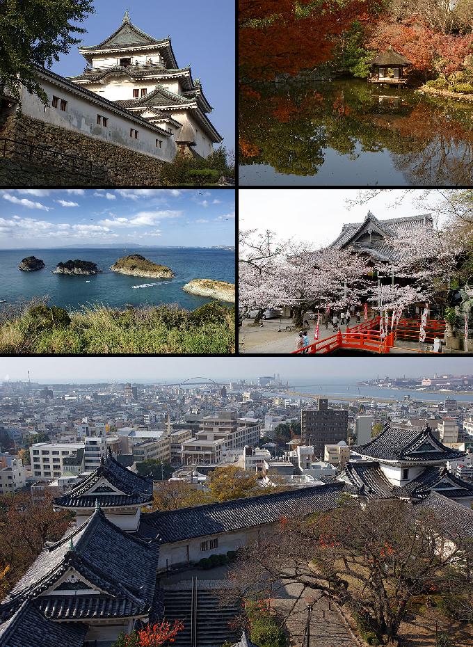 Wakayama Castle, Nishinomaru Garden, Saikazaki, Kimiidera Temple, Downtown Wakayama viewed from the castle keep | |
 Flag  Seal | |
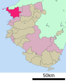
 Location of Wakayama in Wakayama Prefecture | |
 | |
 Wakayama | |
| Coordinates: 34°14′N 135°10′E | |
| Country | Japan |
| Region | Honshu (Kansai) |
| Prefecture | Wakayama |
| Government | |
| • Mayor | Masahiro Obana |
| Area | |
| • Total | 208.84 km2 (80.63 sq mi) |
| Population (December 1, 2021) | |
| • Total | 351,391 |
| • Density | 1,700/km2 (4,400/sq mi) |
| Time zone | UTC+9 (Japan Standard Time) |
| - Tree | Cinnamomum camphora |
| - Flower | Azalea |
| Address | 23 Shichibancho, Wakayama-shi, Wakayama-ken 640-8511 |
| Website | Official website |

Geography
Wakayama is located at the northwest corner of Wakayama Prefecture, bordered by Osaka Prefecture to the north and the Kii Channel and Kitan Strait to the west. It is located on the mouth of the Kinokawa River with the main urban center of the city on the river's left bank.
Neighboring municipalities
Wakayama Prefecture
Osaka Prefecture
Hyōgo Prefecture
- Sumoto, Hyōgo (separated by the Kitan Strait)
Climate
Wakayama has a Humid subtropical climate (Köppen Cfa) characterized by warm summers and cool winters with light to no snowfall. The average annual temperature in Wakayama is 15.6 °C. The average annual rainfall is 1713 mm with September as the wettest month. The temperatures are highest on average in August, at around 26.4 °C, and lowest in January, at around 5.4 °C.[2] The area is subject to typhoons in summer.
| Climate data for Wakayama (1991−2020 normals, extremes 1879−present) | |||||||||||||
|---|---|---|---|---|---|---|---|---|---|---|---|---|---|
| Month | Jan | Feb | Mar | Apr | May | Jun | Jul | Aug | Sep | Oct | Nov | Dec | Year |
| Record high °C (°F) | 21.2 (70.2) |
22.0 (71.6) |
24.5 (76.1) |
30.0 (86.0) |
32.4 (90.3) |
35.3 (95.5) |
37.8 (100.0) |
38.5 (101.3) |
35.8 (96.4) |
32.3 (90.1) |
27.7 (81.9) |
25.2 (77.4) |
38.5 (101.3) |
| Average high °C (°F) | 9.8 (49.6) |
10.7 (51.3) |
14.3 (57.7) |
19.7 (67.5) |
24.3 (75.7) |
27.1 (80.8) |
31.1 (88.0) |
32.6 (90.7) |
29.0 (84.2) |
23.4 (74.1) |
17.9 (64.2) |
12.5 (54.5) |
21.0 (69.8) |
| Daily mean °C (°F) | 6.2 (43.2) |
6.7 (44.1) |
9.9 (49.8) |
15.1 (59.2) |
19.7 (67.5) |
23.2 (73.8) |
27.2 (81.0) |
28.4 (83.1) |
24.9 (76.8) |
19.3 (66.7) |
13.8 (56.8) |
8.6 (47.5) |
16.9 (62.4) |
| Average low °C (°F) | 2.9 (37.2) |
3.1 (37.6) |
5.8 (42.4) |
10.7 (51.3) |
15.6 (60.1) |
20.1 (68.2) |
24.3 (75.7) |
25.1 (77.2) |
21.5 (70.7) |
15.6 (60.1) |
9.9 (49.8) |
5.1 (41.2) |
13.3 (55.9) |
| Record low °C (°F) | −6.0 (21.2) |
−5.4 (22.3) |
−4.0 (24.8) |
−1.4 (29.5) |
3.7 (38.7) |
9.0 (48.2) |
14.4 (57.9) |
13.5 (56.3) |
11.2 (52.2) |
4.3 (39.7) |
−0.6 (30.9) |
−3.0 (26.6) |
−6.0 (21.2) |
| Average precipitation mm (inches) | 48.7 (1.92) |
62.0 (2.44) |
96.9 (3.81) |
98.4 (3.87) |
146.6 (5.77) |
183.5 (7.22) |
175.8 (6.92) |
101.8 (4.01) |
181.3 (7.14) |
160.8 (6.33) |
95.9 (3.78) |
62.7 (2.47) |
1,414.4 (55.69) |
| Average snowfall cm (inches) | 0 (0) |
1 (0.4) |
0 (0) |
0 (0) |
0 (0) |
0 (0) |
0 (0) |
0 (0) |
0 (0) |
0 (0) |
0 (0) |
0 (0) |
1 (0.4) |
| Average precipitation days (≥ 0.5 mm) | 7.2 | 7.9 | 10.3 | 10.0 | 10.4 | 12.5 | 10.6 | 7.2 | 10.2 | 9.6 | 7.3 | 7.7 | 111.1 |
| Average relative humidity (%) | 61 | 61 | 60 | 61 | 64 | 72 | 73 | 70 | 69 | 67 | 66 | 63 | 66 |
| Mean monthly sunshine hours | 135.8 | 143.1 | 179.6 | 196.9 | 207.6 | 157.6 | 206.1 | 239.9 | 173.2 | 169.9 | 147.7 | 135.4 | 2,100.1 |
| Source: Japan Meteorological Agency[3] | |||||||||||||
Demographics
Per Japanese census data,[4] the population of Wakayama peaked in the 1980s and has been declining slowly since.
| Year | Pop. | ±% |
|---|---|---|
| 1960 | 285,155 | — |
| 1970 | 365,267 | +28.1% |
| 1980 | 400,802 | +9.7% |
| 1990 | 396,553 | −1.1% |
| 2000 | 386,551 | −2.5% |
| 2010 | 369,400 | −4.4% |
History
The area of the modern city of Wakayama was the center of ancient Kii Province, and the Iwase-Senzuka Kofun Cluster is one of the largest clusters of kofun burial mounds in Japan. The area the home of the Kii Kuni no miyatsuko, a local king ruling the Kinokawa River Valley prior to the rise of the Yamato State. During the Nara period priests from Tang China built the Kimii-dera temple. From the Muromachi period, Waka-no-ura was a port on the Kinokawa River, and Toyotomi Hideyoshi constructed the predecessor of Wakayama Castle during his conquest of Kii Province during the Sengoku period. During the Edo period, the castle town at the base of Wakayama Castle grew and prospered under the rule of the Kii Tokugawa clan as the center of Kishū Domain. After the Meiji restoration, Wakayama was granted city status on April 1, 1889 with the creation of the modern municipalities system. The city suffered 1208 deaths and 1560 critically wounded in the July 9, 1945 Bombing of Wakayama during World War II, which destroyed more than half of the urban area. On April 1, 1997, Wakayama attained core city status, with increased local autonomy.
Government
Wakayama has a mayor-council form of government with a directly elected mayor and a unicameral city council of 38 members. Wakayama contributes 15 members to the Wakayama Prefectural Assembly. In terms of national politics, the city is divided between Wakayama 1st district and Wakayama 2nd district of the lower house of the Diet of Japan.
Economy
Wakayama is the main commercial city of northern Wakayama and is the largest city in Wakayama Prefecture. Primary industries include agriculture, notably rice and citrus fruits, and commercial fishing. Secondary industries are centered around electronics and heavy industry. Nippon Steel remains a major employer, although the city suffered considerably when former Sumitomo Steel shifted much of its production to China. Other major employers include Kao Corporation and Mitsubishi Electric.
Education
Colleges and Universities
- Wakayama University
- Wakayama Medical University
- Wakayama Shin-ai University
- Wakayama College of Science Studies
- Tokyo Health Care University School of Nursing
- Takarazuka University of Medical and Health Care MedicalSchool
Primary and secondary education
Wakayama has 50 public elementary schools, 19 public middle schools and one public high school operated by the city government and one private elementary school and three private middle schools. The Wakayama Prefectural Board of Education operates two public middle schools and 10 public high schools. There are also four private high schools.In addition, there is one elementary school and one high school run by Wakayama University.
The prefecture also operates five special education school for the handicapped, and one more is operated by Wakayama University.
The city has one North Korean school, Wakayama Korean Elementary and Middle School (和歌山朝鮮初中級学校).[5]
Transportation
Railway
![]() JR West – Hanwa Line
JR West – Hanwa Line
- Kii - Musota - Kii-Nakanoshima - Wakayama
![]() JR West – Kisei Main Line
JR West – Kisei Main Line
- Kimiidera - Miyamae - Wakayama - Kiwa - Wakayamashi
![]() JR West – Wakayama Line
JR West – Wakayama Line
![]() Wakayama Electric Railway Kishigawa Line
Wakayama Electric Railway Kishigawa Line
- Wakayama - Tanakaguchi - Nichizengū - Kōzaki - Kamayama - Kōtsū Center Mae - Okazakimae - Kire - Idakiso - Sandō
![]() Nankai Electric Railway Nankai Main Line
Nankai Electric Railway Nankai Main Line
![]() Nankai Electric Railway Wakayamako Line
Nankai Electric Railway Wakayamako Line
![]() Nankai Electric Railway Kada Line
Nankai Electric Railway Kada Line
- Wakayamashi - Kinokawa - Higashi-Matsue - Nakamatsue - Hachimanmae - Nishinoshō - Nirigahama - Isonoura - Kada
Highway
 Hanwa Expressway
 Keinawa Expressway
 National Route 24
 National Route 26
 National Route 42
Sister cities
Wakayama has sister-city relationships with four overseas municipalities:[6]
 Bakersfield, California, United States
 Jeju, Jeju Province, South Korea
 Richmond, British Columbia, Canada
 Jinan, Shandong, China
Wakayama City formed a sister-city relationship with the city of Jinan mainly due to the efforts of Hiroshi Yamazaki (山崎 宏), who was an escaped medic in the Imperial Japanese Army and stayed in China after the war. He married and runs his own clinic in China. In 1976, he visited Wakayama after nearly 40 years.[citation needed]
Local attractions
- Wakayama Castle
- Kimiidera
- Hinokuma Shrine
- Itakiso Shrine
- Kamayama Shrine
- Kishū Tōshō-gū
- Wakayama Marina City[7]
- The Museum of Modern Art, Wakayama
- Wakayama is home to one of Japan's three Melody Roads, which is made from grooves cut into the pavement, which when driven over causes a tactile vibration and audible rumbling transmitted through the wheels into the car body.[8][9]
Wakayama Prefecture is famous across Japan for its umeboshi (salty pickled plums) and mikan (mandarins).
 Art Cube of Wakanoura
 Kimiidera
 The Museum of Modern Art, Wakayama


References
- "Wakayama city official statistics" (in Japanese). Japan.
- Wakayama climate data
- 気象庁 / 平年値(年・月ごとの値). Japan Meteorological Agency. Retrieved May 19, 2021.
- Wakayama population statistics
- ウリハッキョ一覧. Chongryon. Retrieved October 14, 2015. (Archive).
- "Wakayama City: English Language Resources Center". Archived from the original on 2011-02-20. Retrieved 2011-02-19.
- "Wakayama City: English Language Resources Center". Archived from the original on 23 September 2015. Retrieved 26 August 2015.
- Johnson, Bobbie (13 November 2007). "Japan's melody roads play music as you drive". The Guardian. Farringdon Road, London, England: GMG. p. 19 (International section). Retrieved 20 October 2008.
- "Your car as a musical instrument - Melody Roads". Noise Addicts. 29 September 2008. Retrieved 20 October 2008.
External links
- Wakayama City official website (in Japanese)
- Wakayama City official website (in English)
- Wakayama City official Youtube channel(in Japanese)
- Wakayama City Tourist Association (in English)
- Waiker's Guide Map to Wakayama (in English)
 Geographic data related to Wakayama at OpenStreetMap
Wakayama (capital) | ||
| Core city |  | |
| Cities | ||
| Districts | ||
List of mergers in Wakayama Prefecture | ||
| 2,000,000 and more | |
|---|---|
| 1,000,000–1,999,999 | |
| 500,000–999,999 | |
| 200,000–499,999 |
|
Authority control | |
|---|---|
| General | |
| National libraries | |
| Scientific databases | |
| Other |
|
На других языках
[de] Wakayama
Wakayama (japanisch 和歌山市, -shi) ist eine Großstadt und Verwaltungssitz der Präfektur Wakayama auf der japanischen Hauptinsel Honshū.- [en] Wakayama (city)
[es] Wakayama
Wakayama (和歌山市, Wakayama-shi?) es una ciudad localizada en la prefectura de Wakayama, Japón. En junio de 2019 tenía una población estimada de 356.381 habitantes y una densidad de población de 1.706 personas por km². Su área total es de 208,84 km².[ru] Вакаяма (город)
Вакая́ма (яп. 和歌山市 Вакаяма-си) — центральный город Японии, административный центр префектуры Вакаяма.Другой контент может иметь иную лицензию. Перед использованием материалов сайта WikiSort.org внимательно изучите правила лицензирования конкретных элементов наполнения сайта.
WikiSort.org - проект по пересортировке и дополнению контента Википедии