world.wikisort.org - Japan
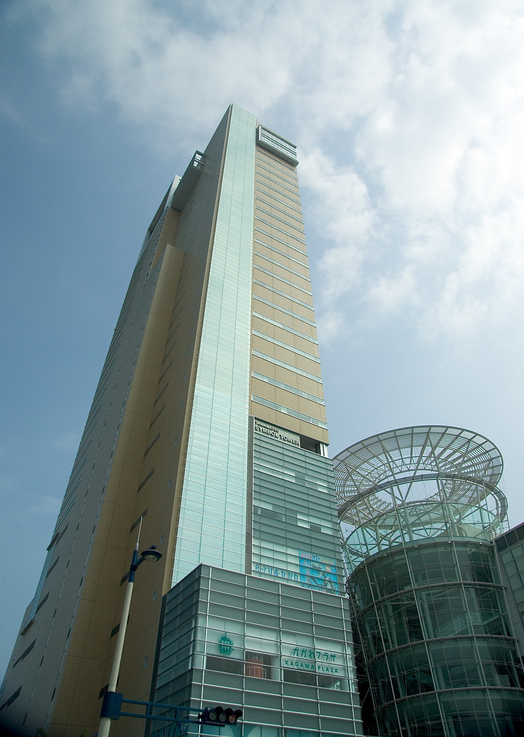
Takamatsu (高松市, Takamatsu-shi, Japanese: [takaꜜmatsɯ]) is a city in central Kagawa Prefecture on the island of Shikoku in Japan, and is the capital city of the prefectural government. It is designated a core city by the Japanese Government. It is a port city on the Seto Inland Sea, and is the closest port to Honshu from Shikoku island. For this reason, it flourished under the daimyō (feudal lords) as a castle town in the fiefdom of Takamatsu, during the Edo period. Takamatsu is a city with a large concentration of nationwide companies' branch offices, which play a large role in its economy, and it contains most of the national government's branch offices for Shikoku. The castle tower formerly used as the symbol of the city was destroyed during the Meiji period. In 2004, construction of the Symbol Tower, the new symbol of Takamatsu, was completed. The Symbol Tower is in the Sunport area of the city. The Symbol Tower is the tallest building in Takamatsu, and is right next to another tall building The JR Clement Hotel (formerly the ANA Clement Hotel), which is also part of the Sunport complex.
Takamatsu
高松市 | |
|---|---|
Core city | |
 From top left: Central Takamatsu, Chūō dōri street, Takamatsu Castle, Marugame-machi shopping mall, Ritsurin Garden | |
 Flag  Seal | |
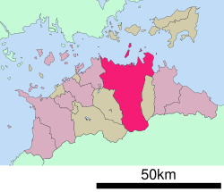
 Location of Takamatsu in Kagawa Prefecture | |
 | |
 Takamatsu Location in Japan | |
| Coordinates: 34°21′N 134°3′E | |
| Country | |
| Region | Shikoku |
| Prefecture | Kagawa Prefecture |
| First official recorded | 667 AD |
| City Settled | February 15, 1890 |
| Government | |
| • Mayor | Hideto Ōnishi |
| Area | |
| • Total | 375.41 km2 (144.95 sq mi) |
| Population (June 1, 2019) | |
| • Total | 418,994 |
| • Density | 1,100/km2 (2,900/sq mi) |
| Time zone | UTC+09:00 (JST) |
| City hall address | 1-8-15 Banchō, Takamatsu-shi, Kagawa-ken 760-8571 |
| Climate | Cfa |
| Website | www |
| Symbols | |
| Flower | Azalea |
| Tree | Pine |
The Sunport Takamatsu covers the area of the Symbol Tower, the JR Clement Hotel, and a miniature mall called Maritime Plaza. The Takamatsu Bus station is also right next to Maritime Plaza. Various buses including the Kotoden Bus run through town, to Ritsurin Park, and to the airport. Sunport Takamatsu is also connected to the ports of Takamatsu. Takamatsu Airport is in Takamatsu.
On September 26, 2005, the town of Shionoe (from Kagawa District) was merged into Takamatsu.
On January 10, 2006, Takamatsu absorbed the following towns: Aji and Mure (from Kita District), Kagawa and Kōnan (from Kagawa District), and Kokubunji (from Ayauta District).
History
The city was officially founded on February 15, 1890. It had been a political and economic center in this area since the Edo period when the Matsudaira clan made Takamatsu the capital of their han.
Takamatsu was selected as a target by the United States' XXI Bomber Command because the city was thought to be an important focal point of Shikoku's rail and road transit systems, and containing some industry vital to supporting the war effort.
On July 3, 1945, towards the end of World War II, at 6:40 PM (JST) 128 B-29 aircraft took off to bomb Takamatsu. Over 800 tons of incendiary bombs were dropped on Takamatsu, destroying 78% of the built-up areas of the city.[1]
Its name means "Tall Pine(s)".
Economy
Companies headquartered in the city include:
Asiana Airlines operates a sales office on the twelfth floor of the Nihon Seimei Ekimae Building in Takamatsu.[4]
Tourism
The city's major tourist attraction is Ritsurin Garden, a feudal lord garden created in the Edo period. Designated as a Special Place of Scenic Beauty by the Japanese government, Ritsurin Garden is especially popular during spring and autumn where night-time illuminations showcase cherry blossoms and autumn colours respectively.
Takamatsu Castle is known for using seawater in its moat and recently the old keep of the castle was successfully restored and opened for public viewing.[5]
In the east of Takamatsu City lies the Yashima lava plateau which is home to various sightseeing spots. At the base of the mountain is the open air museum Shikoku Mura where aspects of regional history and culture are exhibited. On the mountain itself is Yashima-ji, number 84 of the Shikoku 88 temple pilgrimage. At the top of the mountain there is also an observation deck which offers views across the Seto Inland Sea.
Takamatsu also acts as a hub to access various islands of the Seto Inland Sea. These include, Megijima, Ogijima, Naoshima, Teshima and Shōdoshima. Since 2010, Takamatsu, along with these islands and more, has been host to the Setouchi Triennale, a contemporary art festival with many outdoor exhibitions by prominent artists from across the world.
Sports teams
- Kagawa Five Arrows (Basketball, B.League)
- Kagawa Olive Guyners (Baseball)
- Kamatamare Sanuki (Football)
- Kagawa Ice Fellows (Ice Hockey)
Education
Universities
- Kagawa University
- Kagawa Prefectural College of Health Sciences
- Takamatsu University
Geography and demographics
As of October 1, 2010, the city had an estimated population of 419,429 with a population density of 1,118 persons per km2.[6] The total area is 375.41 square kilometres (144.95 sq mi) following the September 26, 2005, and January 10, 2006, expansions.
Crime and safety
The Shinwa-kai yakuza syndicate is based in Takamatsu. The Shinwa-kai is the only designated yakuza group based in the Shikoku region.[7]
In October 2017, Japan Today reported 5 people received minor injuries when a wild boar entered a local Aeon mall.[8]
Climate
Takamatsu has a humid subtropical climate (Köppen climate classification Cfa) with hot, humid summers, and cool winters. Some rain falls throughout the year, but the months from May to September have the heaviest rain.
| Climate data for Takamatsu (1991−2020 normals, extremes 1941−present) | |||||||||||||
|---|---|---|---|---|---|---|---|---|---|---|---|---|---|
| Month | Jan | Feb | Mar | Apr | May | Jun | Jul | Aug | Sep | Oct | Nov | Dec | Year |
| Record high °C (°F) | 18.9 (66.0) |
24.0 (75.2) |
25.5 (77.9) |
30.9 (87.6) |
32.6 (90.7) |
36.5 (97.7) |
38.2 (100.8) |
38.6 (101.5) |
37.6 (99.7) |
34.0 (93.2) |
26.6 (79.9) |
21.2 (70.2) |
38.6 (101.5) |
| Average high °C (°F) | 9.7 (49.5) |
10.5 (50.9) |
14.1 (57.4) |
19.8 (67.6) |
24.8 (76.6) |
27.5 (81.5) |
31.7 (89.1) |
33.0 (91.4) |
28.8 (83.8) |
23.2 (73.8) |
17.5 (63.5) |
12.1 (53.8) |
21.1 (70.0) |
| Daily mean °C (°F) | 5.9 (42.6) |
6.3 (43.3) |
9.4 (48.9) |
14.7 (58.5) |
19.8 (67.6) |
23.3 (73.9) |
27.5 (81.5) |
28.6 (83.5) |
24.7 (76.5) |
19.0 (66.2) |
13.2 (55.8) |
8.1 (46.6) |
16.7 (62.1) |
| Average low °C (°F) | 2.1 (35.8) |
2.2 (36.0) |
5.0 (41.0) |
9.9 (49.8) |
15.1 (59.2) |
19.8 (67.6) |
24.1 (75.4) |
25.1 (77.2) |
21.2 (70.2) |
15.1 (59.2) |
9.1 (48.4) |
4.3 (39.7) |
12.8 (55.0) |
| Record low °C (°F) | −7.7 (18.1) |
−6.0 (21.2) |
−4.4 (24.1) |
−2.4 (27.7) |
2.8 (37.0) |
7.5 (45.5) |
15.3 (59.5) |
15.8 (60.4) |
9.4 (48.9) |
2.0 (35.6) |
−1.8 (28.8) |
−5.3 (22.5) |
−7.7 (18.1) |
| Average precipitation mm (inches) | 39.4 (1.55) |
45.8 (1.80) |
81.4 (3.20) |
74.6 (2.94) |
100.9 (3.97) |
153.1 (6.03) |
159.8 (6.29) |
106.0 (4.17) |
167.4 (6.59) |
120.1 (4.73) |
55.0 (2.17) |
46.7 (1.84) |
1,150.1 (45.28) |
| Average snowfall cm (inches) | 0 (0) |
1 (0.4) |
0 (0) |
0 (0) |
0 (0) |
0 (0) |
0 (0) |
0 (0) |
0 (0) |
0 (0) |
0 (0) |
0 (0) |
1 (0.4) |
| Average precipitation days (≥ 0.5 mm) | 7.5 | 8.0 | 10.8 | 10.1 | 9.4 | 11.5 | 10.5 | 7.9 | 10.5 | 9.3 | 7.8 | 7.9 | 111.3 |
| Average relative humidity (%) | 63 | 63 | 62 | 62 | 64 | 72 | 73 | 70 | 72 | 70 | 69 | 66 | 67 |
| Mean monthly sunshine hours | 141.4 | 143.8 | 175.0 | 194.5 | 210.1 | 158.2 | 191.8 | 221.2 | 159.6 | 164.6 | 145.5 | 142.7 | 2,046.5 |
| Source: Japan Meteorological Agency[9] | |||||||||||||
| Climate data for Kōnan, Takamatsu (2003−2020 normals, extremes 2003−present) | |||||||||||||
|---|---|---|---|---|---|---|---|---|---|---|---|---|---|
| Month | Jan | Feb | Mar | Apr | May | Jun | Jul | Aug | Sep | Oct | Nov | Dec | Year |
| Record high °C (°F) | 16.6 (61.9) |
22.8 (73.0) |
25.2 (77.4) |
29.6 (85.3) |
31.9 (89.4) |
34.8 (94.6) |
36.0 (96.8) |
37.8 (100.0) |
35.5 (95.9) |
31.9 (89.4) |
24.9 (76.8) |
19.4 (66.9) |
37.8 (100.0) |
| Average high °C (°F) | 8.2 (46.8) |
9.3 (48.7) |
13.1 (55.6) |
18.8 (65.8) |
23.7 (74.7) |
26.4 (79.5) |
30.2 (86.4) |
31.7 (89.1) |
27.5 (81.5) |
21.9 (71.4) |
16.3 (61.3) |
10.5 (50.9) |
19.8 (67.6) |
| Daily mean °C (°F) | 4.1 (39.4) |
4.9 (40.8) |
8.0 (46.4) |
13.3 (55.9) |
18.3 (64.9) |
21.8 (71.2) |
25.6 (78.1) |
26.7 (80.1) |
22.8 (73.0) |
17.3 (63.1) |
11.8 (53.2) |
6.5 (43.7) |
15.1 (59.2) |
| Average low °C (°F) | 0.4 (32.7) |
0.7 (33.3) |
3.0 (37.4) |
7.9 (46.2) |
13.0 (55.4) |
17.7 (63.9) |
22.0 (71.6) |
22.8 (73.0) |
19.1 (66.4) |
13.3 (55.9) |
7.7 (45.9) |
2.7 (36.9) |
10.9 (51.5) |
| Record low °C (°F) | −5.6 (21.9) |
−5.5 (22.1) |
−3.6 (25.5) |
−1.1 (30.0) |
2.9 (37.2) |
9.7 (49.5) |
16.3 (61.3) |
15.9 (60.6) |
11.0 (51.8) |
4.6 (40.3) |
−0.4 (31.3) |
−4.9 (23.2) |
−5.6 (21.9) |
| Average precipitation mm (inches) | 41.0 (1.61) |
54.8 (2.16) |
84.8 (3.34) |
77.8 (3.06) |
105.5 (4.15) |
160.7 (6.33) |
193.2 (7.61) |
150.1 (5.91) |
214.4 (8.44) |
148.4 (5.84) |
64.4 (2.54) |
59.0 (2.32) |
1,353.9 (53.30) |
| Average precipitation days (≥ 1.0 mm) | 6.6 | 8.4 | 10.1 | 9.8 | 8.3 | 11.1 | 10.5 | 8.7 | 10.2 | 8.5 | 8.0 | 7.9 | 108.1 |
| Source: Japan Meteorological Agency[10][11] | |||||||||||||
Demographics
Per Japanese census data, the population of Takamatsu in 2020 is 417,496 people.[12] Takamatsu has been conducting censuses since 1920.
|
|
| ||||||||||||||||||||||||||||||||||||||||||||||||||||||||||||||||||||||||
| Takamatsu population statistics[12] | ||||||||||||||||||||||||||||||||||||||||||||||||||||||||||||||||||||||||||
Transportation
The main train station is Takamatsu Station, operated by JR Shikoku. Trains from here run to destinations around Shikoku, as well as Okayama Station on Honshū via the Seto-Ōhashi Bridge. The private Kotoden railway connects much of Takamatsu, with a hub and department store at Kawaramachi Station, and Takamatsu-Chikko Station nearby Takamatsu Station.
Long-distance coach services operate from the city to destinations such as Ōsaka, Kyoto, Tokyo, and Hiroshima.
Buses and trains operated by Kotoden accept a contactless payment card for travel called an IruCa.[13]
International relations
Twin towns – Sister cities
Takamatsu is twinned with:
 St. Petersburg, United States[14]
 Tours, France[15]
Friendship cities
Takamatsu has friendship arrangements with:
In literature

- Takamatsu is the main setting for Haruki Murakami's novel Kafka on the Shore.
- The naval commander Tameichi Hara, born in Takamatsu in 1900, recounts his childhood there in the memoir Japanese Destroyer Captain.[18]
- Takamatsu is the main setting for the manga and anime Poco's Udon World.
Notable people
The following politicians, celebrities, and other well-known people are from Takamatsu (listed alphabetically by surname):
- Warabé Aska (Painter/illustrator, born 1944)
- Ema Fujisawa (actor, born 1982)
- Shinichiro Furumoto (politician, born 1956)
- Yoshihiro Hamaguchi (Olympic athlete, 1926-2011)
- Takuya Hirai (politician, born 1958)
- Ikuko Kawai (musician and composer, born 1968)
- Kan Kikuchi (writer and publisher, 1888-1948)
- Akiko Kinouchi (actor, born 1981)
- Makoto Kitano (soccer player, born 1967)
- Kenji Kobayashi (shogi player, born 1957)
- Akihito Kondo (baseball player, 1938-2019)
- Yasuhiro Konishi (karateka, 1893-1983)
- Bukichi Miki (politician, 1884-1956)
- Ryuki Miki (tennis player, 1904-1967)
- Lu Wanyao (golfer, born 1996)
- Yoshiro Maeda (mixed martial artist, born 1981)
- Shigeru Makino (baseball player, 1928-1984)
- Ryuya Matsumoto (baseball player, born 1994)
- Kojin Nakakita (sledge hockey coach, born 1963)
- Futoshi Nakanishi (baseball player, born 1933)
- Kiyotaka Nanbara (comedian and TV personality, born 1965)
- Ayano Ninomiya (violinist, born 1971)
- Tetsuya Noguchi (artist, born 1980)
- Junya Ogawa (politician, born 1971)
- Kentaro Sonoura (politician, born 1972)
- Mikuru Suzuki (darts player, born 1982)
- Daisuke Tsuda (singer and drummer, born 1977)
- Ayako Uehara (pianist, born 1980)
- Emiko Uematsu (politician, born 1967)
- Satoru Uyama (fencer, born 1991)
See also
- Kagawa Prefecture
- Seto Inland Sea
- Busshozan
- Yashima, Kagawa
References
- "21st Bomber Command Tactical Mission Report 247, 250, Ocr | Aviation | Armed Conflict".
- "Company Information Archived 2010-03-24 at the Wayback Machine." Shikoku Railway Company. Retrieved on March 27, 2010.
- "Corporate Profile Archived 2016-03-04 at the Wayback Machine." Tadano Limited. Retrieved on April 15, 2015.
- "Worldwide Offices Japan." Asiana Airlines. Retrieved on January 19, 2009.
- 高松城天守閣復元. www.takamatsujyo.com. Retrieved 2016-01-19.
- Hideto, Onishi. "Takamatsu City Profile". Takamatsu City Website. Archived from the original on 27 May 2009. Retrieved 10 May 2014.
- "2021 Police White Paper Chapter 2 : Furtherance of Organized Crime Countermeasures", 2021, National Police Agency (in Japanese)
- "5 injured after wild boar goes on rampage through Kagawa mall, 2007, Japan Today (in English)
- 気象庁 / 平年値(年・月ごとの値). Japan Meteorological Agency. Retrieved May 19, 2021.
- 観測史上1~10位の値(年間を通じての値). JMA. Retrieved April 24, 2022.
- 気象庁 / 平年値(年・月ごとの値). JMA. Retrieved April 24, 2022.
- Takamatsu population statistics
- "Takamatsu Japan, what to do there". 20 December 2009. Retrieved 2010-03-13.
- "St. Petersburg". Takamatsu city. Archived from the original on 2009-06-11. Retrieved 2009-05-26.
- "Tours". Takamatsu city. Archived from the original on 2009-06-11. Retrieved 2009-05-26.
- "Nanchang". Takamatsu city. Archived from the original on 2009-06-11. Retrieved 2009-05-26.
- "Nanchang City and Sister Cities Intercommunion". Nanchang Municipal Party Committee of the CPC and Nanchang Municipal Government. Nanchang Economic Information Center. Archived from the original on 2013-05-22. Retrieved 2013-11-05.
- Hara, Tameichi (1961). "Born A Samurai". Japanese Destroyer Captain. New York & Toronto: Ballantine Books. ISBN 978-1-59114-354-3. OCLC 255849609.
External links
- Takamatsu City official website (in Japanese)
- Experience Takamatsu-Sense of Wonder- - Official account of Takamatsu city about tourism.
 Geographic data related to Takamatsu at OpenStreetMap
 Takamatsu travel guide from Wikivoyage
 Media related to Takamatsu, Kagawa at Wikimedia Commons
Takamatsu (capital) | ||
| Core city | ||
| Cities | ||
| Districts | ||
| Others |
| |
List of mergers in Kagawa Prefecture | ||
| 2,000,000 and more | |
|---|---|
| 1,000,000–1,999,999 | |
| 500,000–999,999 | |
| 200,000–499,999 |
|
Authority control | |
|---|---|
| General | |
| National libraries | |
| Scientific databases | |
| Other |
|
На других языках
[de] Takamatsu
Takamatsu (japanisch 高松市, -shi, wörtlich: hohe Kiefer) ist eine Großstadt und Verwaltungssitz der japanischen Präfektur Kagawa. Sie liegt an der japanischen Seto-Inlandsee im Norden der Insel Shikoku. Mit dem Hafen als Zentrum zieht sie sich landeinwärts durch die küstennahe Ebene und ist an den Rändern von Bergen und Hügeln eingegrenzt.- [en] Takamatsu
[es] Takamatsu
La ciudad de Takamatsu (高松市, Takamatsu-shi?) es una ciudad situada en la prefectura de Kagawa, en Japón. Tiene una población estimada, en marzo de 2022, de 414 885 habitantes.[3][ru] Такамацу
Такама́цу (яп. 高松市 Такамацу-си) — центральный город Японии, административный центр префектуры Кагава на острове Сикоку, крупный порт на Внутреннем японском море. 26 сентября 2005 года и 10 января 2006 года Такамацу был расширен за счёт присоединения посёлков Сионоэ, Мурэ, Адзи, Кагава, Конан и Кокубундзи. Площадь города составляет 375,14 км²[1], население — 420 729 человек (1 августа 2014)[2], плотность населения — 1121,53 чел./км².Другой контент может иметь иную лицензию. Перед использованием материалов сайта WikiSort.org внимательно изучите правила лицензирования конкретных элементов наполнения сайта.
WikiSort.org - проект по пересортировке и дополнению контента Википедии