world.wikisort.org - Japan
Tsu (津市, Tsu-shi) is a city located in Mie Prefecture, Japan. As of 31 July 2021[update], the city had an estimated population of 274,879 in 127,273 households and a population density of 390 persons per km².[1] The total area of the city is 711.11 square kilometres (274.56 sq mi). Although the second largest city in the prefecture in terms of population, its designation as the prefectural capital and its holding of a large concentration of national government offices and educational facilities make the city the administrative and educational center of Mie Prefecture.
This article needs additional citations for verification. (December 2013) |
Tsu
津市 | |||||||
|---|---|---|---|---|---|---|---|
City | |||||||

| |||||||
 Flag  Seal | |||||||
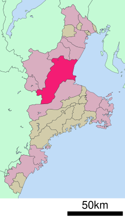
 Location of Tsu in Mie Prefecture | |||||||
 | |||||||
 Tsu | |||||||
| Coordinates: 34°43′6.4″N 136°30′20.6″E | |||||||
| Country | Japan | ||||||
| Region | Kansai, Tōkai | ||||||
| Prefecture | Mie | ||||||
| Government | |||||||
| • -Mayor | Yasuyuki Maeba (since May 2011) | ||||||
| Area | |||||||
| • Total | 711.11 km2 (274.56 sq mi) | ||||||
| Population (August 2021) | |||||||
| • Total | 274,879 | ||||||
| • Density | 390/km2 (1,000/sq mi) | ||||||
| Time zone | UTC+9 (Japan Standard Time) | ||||||
| Symbols | |||||||
| • Tree | Zelkova serrata | ||||||
| • Flower | Azalea | ||||||
| • Bird | Japanese bush warbler | ||||||
| Phone number | 059-229-3110 | ||||||
| Address | 23-1 Nishi-Marunouchi, Tsu-shi, Mie-ken 514-8611 | ||||||
| Website | Official website | ||||||


Geography
Tsu is located in east-central Kii Peninsula, in central Mie Prefecture. It is the largest city in Mie Prefecture in terms of area and stretches the width of Mie Prefecture, and is bordered by Ise Bay on the Pacific Ocean to the east, and Nara Prefecture to the west. Parts of the city are within the limits of the Murō-Akame-Aoyama Quasi-National Park.
Neighboring municipalities
- The city of Suzuka, to the north
- The city of Kameyama, to the north
- The city of Matsusaka, to the south
- The city of Iga, to the west
- The city of Nabari to the west
- The village of Soni, Nara to the west
- The village of Mitsue, Nara to the west
Climate
Tsu has a Humid subtropical climate (Köppen Cfa) characterized by warm summers and cool winters with light to no snowfall. The average annual temperature in Tsu is 15.6 °C. The average annual rainfall is 1931 mm with September as the wettest month. The temperatures are highest on average in August, at around 26.7 °C, and lowest in January, at around 5.0 °C.[2] Precipitation is significant throughout the year, but is heaviest from May to September.
| Climate data for Tsu (1991−2020 normals, extremes 1889−present) | |||||||||||||
|---|---|---|---|---|---|---|---|---|---|---|---|---|---|
| Month | Jan | Feb | Mar | Apr | May | Jun | Jul | Aug | Sep | Oct | Nov | Dec | Year |
| Record high °C (°F) | 19.0 (66.2) |
22.8 (73.0) |
25.9 (78.6) |
31.0 (87.8) |
33.9 (93.0) |
36.7 (98.1) |
39.1 (102.4) |
39.5 (103.1) |
37.7 (99.9) |
31.0 (87.8) |
27.2 (81.0) |
23.7 (74.7) |
39.5 (103.1) |
| Average high °C (°F) | 9.5 (49.1) |
10.0 (50.0) |
13.4 (56.1) |
18.6 (65.5) |
23.1 (73.6) |
26.2 (79.2) |
30.4 (86.7) |
31.6 (88.9) |
28.0 (82.4) |
22.6 (72.7) |
17.1 (62.8) |
12.0 (53.6) |
20.2 (68.4) |
| Daily mean °C (°F) | 5.7 (42.3) |
5.9 (42.6) |
9.0 (48.2) |
14.2 (57.6) |
19.0 (66.2) |
22.7 (72.9) |
26.8 (80.2) |
27.9 (82.2) |
24.4 (75.9) |
18.8 (65.8) |
13.2 (55.8) |
8.1 (46.6) |
16.3 (61.3) |
| Average low °C (°F) | 2.4 (36.3) |
2.4 (36.3) |
5.2 (41.4) |
10.2 (50.4) |
15.4 (59.7) |
19.7 (67.5) |
24.0 (75.2) |
25.0 (77.0) |
21.4 (70.5) |
15.5 (59.9) |
9.5 (49.1) |
4.6 (40.3) |
12.9 (55.2) |
| Record low °C (°F) | −7.8 (18.0) |
−7.0 (19.4) |
−5.6 (21.9) |
−3.0 (26.6) |
3.0 (37.4) |
9.0 (48.2) |
14.6 (58.3) |
14.6 (58.3) |
8.7 (47.7) |
2.3 (36.1) |
−1.4 (29.5) |
−6.4 (20.5) |
−7.8 (18.0) |
| Average precipitation mm (inches) | 48.5 (1.91) |
57.1 (2.25) |
104.5 (4.11) |
129.0 (5.08) |
167.3 (6.59) |
201.8 (7.94) |
173.9 (6.85) |
144.5 (5.69) |
276.6 (10.89) |
186.1 (7.33) |
76.4 (3.01) |
47.2 (1.86) |
1,612.9 (63.50) |
| Average snowfall cm (inches) | 2 (0.8) |
3 (1.2) |
0 (0) |
0 (0) |
0 (0) |
0 (0) |
0 (0) |
0 (0) |
0 (0) |
0 (0) |
0 (0) |
1 (0.4) |
6 (2.4) |
| Average precipitation days (≥ 0.5 mm) | 6.4 | 7.5 | 10.5 | 9.8 | 10.9 | 12.8 | 12.3 | 9.8 | 12.3 | 10.1 | 6.8 | 6.5 | 115.7 |
| Average relative humidity (%) | 61 | 61 | 62 | 64 | 68 | 74 | 75 | 73 | 72 | 69 | 65 | 63 | 67 |
| Mean monthly sunshine hours | 162.9 | 156.2 | 186.1 | 192.7 | 197.8 | 146.9 | 180.2 | 220.7 | 165.3 | 164.5 | 163.7 | 171.5 | 2,108.6 |
| Source: Japan Meteorological Agency[3] | |||||||||||||
Demographics
Per Japanese census data,[4] the population of Tsu has been relatively stable over the past 40 years.
| Year | Pop. | ±% |
|---|---|---|
| 1960 | 226,065 | — |
| 1970 | 242,000 | +7.0% |
| 1980 | 265,443 | +9.7% |
| 1990 | 280,384 | +5.6% |
| 2000 | 286,521 | +2.2% |
| 2010 | 285,728 | −0.3% |
History
This section does not cite any sources. (December 2013) |
Origin
Tsu originally developed as a port town known as Anotsu (安濃津) in the Nara and Heian periods.
The port was destroyed by a tsunami in the 1498 Meiō Nankaidō earthquake.
 Kitabatake Akiyoshi
 Kitabatake Family Residence Gardens(Kitabatake Shrine)


Edo Period
The town was rebuilt as a castle town and a post station by the Tōdō clan, daimyō of Tsu Domain under the Tokugawa shogunate. During the Edo period, it became a popular stopping point for travelers to Ise Grand Shrine, about 40 km to the southeast.
 Tōdō Takatora
 Tsu Castle
 This is a map of Tage castle or Kiriyama castle in Edo period.


Modern Tsu
Following the Meiji Restoration, Tsu became the capital of Mie Prefecture in 1871. With the establishment of then modern municipalities on April 1, 1889, Tsu was one of the original 31 cities to be proclaimed. The city borders gradually expanded, with Tsu annexing the neighboring villages of Tatebe and Tosa in 1909, Shinmachi in 1934, Fujimi in 1936, Takachaya in 1939 and Anto, Kanbe and Kushigata in 1943. During World War II, Allied air raids on July 24 and July 28, 1945, destroyed most of the city and killed 1,239 people. In 1953, Tsu annexed the neighboring villages of Kumozu in 1953, Isshinden, Shiratsuka, Kurima, and Katada in 1954 and Toyosato in 1973.
 Tsu Shinsekai before 1945

On January 1, 2006, the neighboring city of Hisai, the towns of Anō, Geinō and Kawage, and the village of Misato (all in Age District), the towns of Hakusan, Ichishi and Karasu, and the village of Misugi (all in Ichishi District) were merged into Tsu. As a result of the merger, the city became the second largest in Mie by population behind Yokkaichi, and the largest in Mie by area ahead of Matsusaka.
Government
Tsu has a mayor-council form of government with a directly elected mayor and a unicameral city council of 34 members. Tsu contributes seven members to the Mie Prefectural Assembly. In terms of national politics, the city is part of Mie 1st district of the lower house of the Diet of Japan.
Economy
This section needs expansion. You can help by adding to it. (February 2016) |

Imuraya Confectionery, a confectionery company,[5] and ZTV, a cable television operator, are headquartered in Tsu.[6]
Education
Colleges and universities
- Mie University, the prefecture's only national university.
- Tsu City College
- Mie Prefectural College of Nursing
- Takada Junior College
Primary and secondary education
- Tsu has 48 public elementary schools and 19 public middle schools operated by the city government, one public elementary school and one public middle schools affiliated with Mie University and two private middle schools. The city has nine public operated by the Mie Prefectural Board of Education and three private high schools
- The prefecture also operates six special education schools for the disabled.
Transportation


Railway
![]() JR Tōkai – Kisei Main Line
JR Tōkai – Kisei Main Line
![]() JR Tōkai –Meishō Line
JR Tōkai –Meishō Line
- Ise-Hata - Ichishi - Isegi - Ise-Ōi – Ise-Kawaguchi - Sekinomiya - Ieki - Ise-Takehara - Ise-Kamakura - Ise-Yachi - Hitsu - Ise-Okitsu
![]() Kintetsu Railway -Nagoya Line
Kintetsu Railway -Nagoya Line
- Chisato - Toyotsu-Ueno - Shiratsuka - Takadahonzan - Edobashi - Tsu - Tsu-shimmachi - Minamigaoka - Hisai - Momozono
![]() Kintetsu Railway -Osaka Line
Kintetsu Railway -Osaka Line
Ise Railway - Ise Railway Ise Line
- Ise-Ueno – Kawage – Higashi-Ishinden - Tsu
Highway
Expressway
 Ise Expressway
Japan National Route
 National Route 23
 National Route 163
 National Route 165
 National Route 306
 National Route 368
 National Route 369
 National Route 422
- National Route 306]
Sea Ports
- Port of Tsu-Matsusaka
Sister city relations
 – Higashishirakawa, Gifu, since June 28, 1989
 – Osasco, São Paulo, Brazil,[7] since October 18, 1976
 – Zhenjiang, Jiangsu, China[7] – since June 11, 1984
Local attractions
Tsu is famous for its Tōjin Odori (唐人踊り), a festival commemorating the arrival of the Joseon Tongsinsa delegation from Korea during the feudal period.[8] There are two other cities that celebrate Tōjin Odori: Suzuka city in Mie Prefecture and Ushimado-chō in Okayama Prefecture.[9]
The ruins of Tsu Castle have been made into a downtown city park.
Kitabatake Shrine and Yūki Shrine are notable local Shinto shrines.
Culture
Sports
Baseball
- Mie Takatora baseball club(JABA)
Volleyball
- Veertien Mie(V.League)
Notable people
This section does not cite any sources. (December 2013) |
- Sho Gokyu, professional soccer player
- Mika Hagi, 2007 Miss Japan
- Mu Kanazaki, professional soccer player
- Kōji Kitao, sumo wrestler
- Kotokaze Kōki, sumo wrestler
- Ayumi Oka, actress
- Hiroshi Okuda, former president of Toyota Motors
- Edogawa Rampo, author
- Kōdō Sawaki, Zen Buddhist
- Chikara Sakaguchi, politician
- Yuki Hashimoto, politician, former idol
- Hidesaburō Ueno, agricultural scientist
- Saori Yoshida, Olympic wrestler
- Yoshihito Nishioka, professional tennis player
References
- "Tsu city official statistics" (in Japanese). Japan.
- Tsu climate data
- 気象庁 / 平年値(年・月ごとの値). Japan Meteorological Agency. Retrieved May 19, 2021.
- Tsu population statistics
- "Corporate profile." Imuraya Confectionery. March 30, 2008. Retrieved on January 11, 2010.
- Home page. ZTV. Retrieved on October 2, 2009.
- "International Exchange". List of Affiliation Partners within Prefectures. Council of Local Authorities for International Relations (CLAIR). Archived from the original on 5 February 2016. Retrieved 21 November 2015.
- http://www.searchnavi.com/~hp/tojin/eng/ Toujin House
- http://www006.upp.so-net.ne.jp/asao/toujin.htm 唐人踊り (Tōjin Odori)
External links
- Official website
 (in Japanese)
  Geographic data related to Tsu, Mie at OpenStreetMap
Tsu (capital) | ||
| Special city | ||
| Cities | ||
| Districts | ||
List of mergers in Mie Prefecture | ||
| 2,000,000 and more | |
|---|---|
| 1,000,000–1,999,999 | |
| 500,000–999,999 | |
| 200,000–499,999 |
|
Authority control | |
|---|---|
| General | |
| National libraries | |
| Scientific databases | |
| Other |
|
На других языках
[de] Tsu (Mie)
Tsu (jap. 津市, -shi, wörtlich: Hafen) ist eine Stadt und Verwaltungssitz der Präfektur Mie auf Honshū, der Hauptinsel von Japan, an der Ise-Bucht knapp 60 km südlich von Nagoya gelegen.- [en] Tsu, Mie
[es] Tsu (Mie)
Tsu (津市, Tsu-shi?) es una ciudad y capital de la prefectura de Mie, Japón. En junio de 2019 tenía una población de 275.371 habitantes y una densidad de población de 387 personas por km². Su área total es de 711,19 km².[ru] Цу
Цу (яп. 津市 Цу-си) — город в Японии, административный центр префектуры Миэ. Расположен на берегу залива Исе. Площадь города составляет 710,81 км²[1], население — 280 737 человек (1 июня 2014)[2], плотность населения — 394,95 чел./км².Другой контент может иметь иную лицензию. Перед использованием материалов сайта WikiSort.org внимательно изучите правила лицензирования конкретных элементов наполнения сайта.
WikiSort.org - проект по пересортировке и дополнению контента Википедии