world.wikisort.org - Japan
Kihoku (紀北町, Kihoku-chō) is a town located in Mie Prefecture, Japan. As of 1 August 2021[update], the town had an estimated population of 15,077 in 7876 households and a population density of 59 persons per km².[1] The total area of the town was 257.01 square kilometres (99.23 sq mi).
Kihoku
紀北町 | |
|---|---|
Town | |
 Kumano Bay in Kihoku | |
 Flag  Seal | |
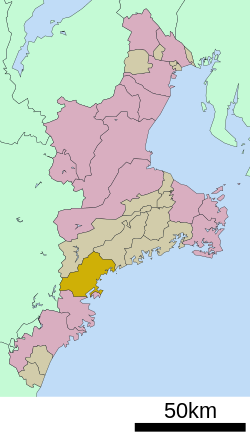 Location of Kihoku in Mie Prefecture | |
 Kihoku | |
| Coordinates: 34°12′41″N 136°20′14″E | |
| Country | Japan |
| Region | Kansai |
| Prefecture | Mie |
| District | Kitamuro |
| Area | |
| • Total | 257.01 km2 (99.23 sq mi) |
| Population (June 2021) | |
| • Total | 15,077 |
| • Density | 59/km2 (150/sq mi) |
| Time zone | UTC+9 (Japan Standard Time) |
| Phone number | 0597-32-3901 |
| Address | 495-8 Aikga, Kihoku-chō, Kitamuro-gun, Mie-ken 519-5701 |
| Climate | Cfa |
| Website | Official website |
| Symbols | |
| Bird | Japanese murrelet |
| Fish | Ocean sunfish |
| Flower | Japanese lily |
| Tree | Hinoki |

Geography
Kihoku is located in southeastern the Kii Peninsula in southern Mie Prefecture, facing the Pacific Ocean. Kihoku is surrounded by river, sea, and mountain, and has a beautiful setting.
Neighboring municipalities
Mie Prefecture
- Owase
- Ōdai
- Taiki
Nara Prefecture
- Kamikitayama
Climate
Kihoku has a Humid subtropical climate (Köppen Cfa) characterized by warm summers and cool winters with light to no snowfall. The average annual temperature in Kihoku is 16.1 °C (61.0 °F). The average annual rainfall is 2,670.2 mm (105.13 in) with September as the wettest month. The temperatures are highest on average in August, at around 26.5 °C (79.7 °F), and lowest in January, at around 6.2 °C (43.2 °F).[2]
| Climate data for Kihoku (1991−2020 normals, extremes 1979−present) | |||||||||||||
|---|---|---|---|---|---|---|---|---|---|---|---|---|---|
| Month | Jan | Feb | Mar | Apr | May | Jun | Jul | Aug | Sep | Oct | Nov | Dec | Year |
| Record high °C (°F) | 20.1 (68.2) |
23.2 (73.8) |
26.2 (79.2) |
31.8 (89.2) |
31.7 (89.1) |
36.4 (97.5) |
37.8 (100.0) |
37.9 (100.2) |
36.7 (98.1) |
31.7 (89.1) |
27.1 (80.8) |
25.4 (77.7) |
37.9 (100.2) |
| Average high °C (°F) | 11.3 (52.3) |
12.2 (54.0) |
15.2 (59.4) |
19.7 (67.5) |
23.2 (73.8) |
25.8 (78.4) |
29.6 (85.3) |
30.9 (87.6) |
28.2 (82.8) |
23.6 (74.5) |
18.8 (65.8) |
13.7 (56.7) |
21.0 (69.8) |
| Daily mean °C (°F) | 6.2 (43.2) |
6.9 (44.4) |
9.8 (49.6) |
14.3 (57.7) |
18.3 (64.9) |
21.6 (70.9) |
25.5 (77.9) |
26.5 (79.7) |
23.7 (74.7) |
18.7 (65.7) |
13.3 (55.9) |
8.3 (46.9) |
16.1 (61.0) |
| Average low °C (°F) | 1.3 (34.3) |
1.8 (35.2) |
4.4 (39.9) |
8.9 (48.0) |
13.5 (56.3) |
18.0 (64.4) |
22.1 (71.8) |
23.0 (73.4) |
20.1 (68.2) |
14.5 (58.1) |
8.4 (47.1) |
3.3 (37.9) |
11.6 (52.9) |
| Record low °C (°F) | −4.7 (23.5) |
−5.1 (22.8) |
−3.0 (26.6) |
−0.9 (30.4) |
3.4 (38.1) |
8.6 (47.5) |
15.3 (59.5) |
15.7 (60.3) |
11.5 (52.7) |
2.7 (36.9) |
−0.9 (30.4) |
−4.1 (24.6) |
−5.1 (22.8) |
| Average precipitation mm (inches) | 70.9 (2.79) |
80.0 (3.15) |
164.3 (6.47) |
207.3 (8.16) |
253.4 (9.98) |
312.9 (12.32) |
273.6 (10.77) |
262.2 (10.32) |
474.0 (18.66) |
333.8 (13.14) |
147.8 (5.82) |
90.2 (3.55) |
2,670.2 (105.13) |
| Average precipitation days (≥ 1.0 mm) | 5.4 | 6.3 | 9.8 | 9.7 | 11.1 | 14.2 | 12.6 | 11.4 | 13.7 | 11.7 | 7.0 | 5.6 | 118.5 |
| Mean monthly sunshine hours | 193.1 | 172.7 | 189.8 | 194.3 | 183.3 | 128.2 | 161.9 | 189.7 | 143.9 | 144.7 | 164.9 | 191.5 | 2,057.9 |
| Source: Japan Meteorological Agency[3][2] | |||||||||||||
Demographics
Per Japanese census data,[4] the population of Kihoku has decreased steadily over the past 40 years.
| Year | Pop. | ±% |
|---|---|---|
| 1920 | 23,407 | — |
| 1930 | 25,190 | +7.6% |
| 1940 | 24,365 | −3.3% |
| 1950 | 32,147 | +31.9% |
| 1960 | 30,336 | −5.6% |
| 1970 | 26,691 | −12.0% |
| 1980 | 26,268 | −1.6% |
| 1990 | 23,663 | −9.9% |
| 2000 | 21,362 | −9.7% |
| 2010 | 18,626 | −12.8% |
History
The area of present-day Kihoku was part of ancient Shima Province, but was transferred to Kii Province in 1582. During this time, large-scale forestry projects were begun. After the Meiji restoration, the area became part of Mie Prefecture. The village of Nagashima was established with the creation of the modern municipalities system on April 1, 1889 and was raised to town status in 1899. It changed its name to Kii-Nagashima in 1970. The town of Kihoku was established on October 11, 2005 by the merger of the towns of Kii-Nagashima and neighboring Miyama.
Government
Kihoku has a mayor-council form of government with a directly elected mayor and a unicameral town council of 16 members. Kihoku, collectively with the city of Owase, contributes two members to the Mie Prefectural Assembly. In terms of national politics, the town is part of Mie 4th district of the lower house of the Diet of Japan.
Economy
Kihoku serves as a commercial center for the surrounding region. Commercial fishing and forestry are the major employers. A well-known product of the former town of Miyama is saury sushi because of the large local catch of saury. At Kihoku, there is the static inverter plant of Kii Channel HVDC system.
Education
Kihoku has nine public elementary schools and four public middle schools operated by the town government. The town does not have a high school.
Transportation
Railway
![]() JR Tōkai – Kisei Main Line
JR Tōkai – Kisei Main Line
- Kii-Nagashima - Minose - Funatsu - Aiga
Highway
 Kisei Expressway
 National Route 42}
 National Route 260
 National Route 422
Local attractions
A portion of the Sacred Sites and Pilgrimage Routes in the Kii Mountain Range, a UNESCO World Heritage Site is located within Kihoku.
Notable people
- Yoshihiko Wada, artist
References
- "Kihoku town official statistics" (in Japanese). Japan.
- 気象庁 / 平年値(年・月ごとの値). JMA. Retrieved April 11, 2022.
- 観測史上1~10位の値(年間を通じての値). JMA. Retrieved April 11, 2022.
- Kihoku population statistics
External links
![]() Media related to Kihoku, Mie at Wikimedia Commons
Media related to Kihoku, Mie at Wikimedia Commons
- Kihoku official website (in Japanese)
Tsu (capital) | ||
| Special city | ||
| Cities | ||
| Districts | ||
List of mergers in Mie Prefecture | ||
На других языках
- [en] Kihoku, Mie
[ru] Кихоку (Миэ)
Кихоку (яп. 紀北町 Кихоку-тё:) — посёлок в Японии, находящийся в уезде Китамуро префектуры Миэ. Площадь посёлка составляет 257,01 км²[1], население — 17 093 человека (1 июня 2014)[2], плотность населения — 66,51 чел./км².Другой контент может иметь иную лицензию. Перед использованием материалов сайта WikiSort.org внимательно изучите правила лицензирования конкретных элементов наполнения сайта.
WikiSort.org - проект по пересортировке и дополнению контента Википедии