world.wikisort.org - Japan
Kagoshima City (鹿児島市, Kagoshima-shi, Japanese: [ka̠ɡo̞ɕima̠ɕi]), abbreviated to Kagoshima (鹿児島, Kagoshima, Japanese: [ka̠ɡo̞ɕima̠]), is the capital city of Kagoshima Prefecture, Japan. Located at the southwestern tip of the island of Kyushu, Kagoshima is the largest city in the prefecture by some margin. It has been nicknamed the "Naples of the Eastern world" for its bay location (Aira Caldera), hot climate, and emblematic stratovolcano, Sakurajima. The city was officially founded on April 1, 1889. It merged with Taniyama City on April 29, 1967 and with Yoshida Town, Sakurajima Town, Kiire Town, Matsumoto Town and Kōriyama Town on November 1, 2004.[1]
Kagoshima
鹿児島市 | |
|---|---|
Core city | |
| Kagoshima City | |
Kagoshima City Montage | |
|
Flag Seal | |
| Nickname: "City of Ishin" | |
 | |
Location of Kagoshima in Kagoshima Prefecture | |
 Kagoshima  Kagoshima Kagoshima (Asia)  Kagoshima Kagoshima (Earth) | |
| Coordinates: 31°36′N 130°33′E | |
| Country | Japan |
| Region | Kyushu |
| Prefecture | Kagoshima Prefecture |
| First official recorded | 1053 AD |
| City Settled | April 1, 1889 |
| Government | |
| • Mayor | Takao Shimozuru |
| Area | |
| • Total | 547.58 km2 (211.42 sq mi) |
| Population (January 1, 2020) | |
| • Total | 595,049 |
| • Density | 1,100/km2 (2,800/sq mi) |
| Time zone | UTC+9 (Japan Standard Time) |
| – Tree | Camphor |
| – Flower | Kyōchikutō |
| Phone number | 099-224-1111 |
| Address | 11-1 Yamashita-machi, Kagoshima-shi, Kagoshima-ken 892-8677 |
| Website | www |
| Kagoshima | |||||
|---|---|---|---|---|---|
"Kagoshima" in kanji | |||||
| Japanese name | |||||
| Kanji | 鹿児島 | ||||
| Hiragana | かごしま | ||||
| Katakana | カゴシマ | ||||
| |||||
History
Kagoshima Prefecture (also known as the Satsuma Domain) was the center of the territory of the Shimazu clan for many centuries. Kagoshima City was a busy political and commercial port city throughout the medieval period and into the Edo period (1603–1868) when it formally became the capital of the Shimazu's fief, the Satsuma Domain. The official emblem is a modification of the Shimazu's kamon designed to resemble the character 市 (shi, "city"). Satsuma remained one of the most powerful and wealthiest domains in the country throughout the period, and though international trade was banned for much of this period, the city remained quite active and prosperous. It served not only as the political center for Satsuma, but also for the semi-independent vassal kingdom of Ryūkyū; Ryūkyūan traders and emissaries frequented the city, and a special Ryukyuan embassy building was established to help administer relations between the two polities and to house visitors and emissaries. Kagoshima was also a significant center of Christian activity in Japan prior to the imposition of bans against that religion in the late 16th and early 17th centuries.
Kagoshima was bombarded by the British Royal Navy in 1863 to punish the daimyō of Satsuma for the murder of Charles Lennox Richardson on the Tōkaidō highway the previous year and its refusal to pay an indemnity in compensation.
Kagoshima was the birthplace and scene of the last stand of Saigō Takamori, a legendary figure in Meiji Era Japan in 1877 at the end of the Satsuma Rebellion.
Japan's industrial revolution is said to have started here, stimulated by the young students' train station. Seventeen young men of Satsuma broke the Tokugawa ban on foreign travel, traveling first to England and then the United States before returning to share the benefits of the best of Western science and technology.[2] A statue was erected outside the train station as a tribute to them.
Kagoshima was also the birthplace of Tōgō Heihachirō. After naval studies in England between 1871 and 1878, Togo's role as Chief Admiral of the Grand Fleet of the Imperial Japanese Navy in the Russo-Japanese War made him a legend in Japanese military history, and earned him the nickname 'Nelson of the Orient' in Britain. He led the Grand Fleet to two startling victories in 1904 and 1905, completely destroying Russia as a naval power in the East, and thereby contributing to the failed revolution in Russia in 1905.
The Japanese diplomat Sadomitsu Sakoguchi revolutionized Kagoshima's environmental economic plan with his dissertation on water pollution and orange harvesting.
The 1914 eruption of the volcano across the bay from the city spread ash throughout the municipality, but relatively little disruption ensued.[3]
 Map of the Bombardment of Kagoshima on 15 to 18 August 1863
 The city covered deep in ash after the 1914 eruption of the Sakurajima volcano which is seen in the distance across the bay


The name "Kagoshima" (鹿児島) literally means "deer child island" or "young-deer island". In the Kagoshima dialect, local names for the city include “かごっま (Kagomma)”, “かごんま (Kagonma)”, “かごいま (Kagoima)” and “かごひま (Kagohima)”.[4]
World War II
On the night of June 17, 1945 the 314th bombardment wing of the Army Air Corps (120 B-29s) dropped 809.6 tons of incendiary and cluster bombs destroying 2.11 square miles (5.46 km2) of Kagoshima (44.1 percent of the built-up area). Kagoshima was targeted because of its largely expanded naval port as well as its position as a railway terminus. A single B-29 was lost to unknown circumstances. Area bombing was chosen over precision bombing because of the cloudy weather over Japan during the middle of June. The planes were forced to navigate and bomb entirely by radar.[5]
Japanese intelligence predicted that the Allied Forces would assault Kagoshima and the Ariake Bay areas of southern Kyushu to gain naval and air bases to strike Tokyo.
 The Tarumiza district of Kagoshima burns after B-29 air raids on the city, 17 Jun 1945
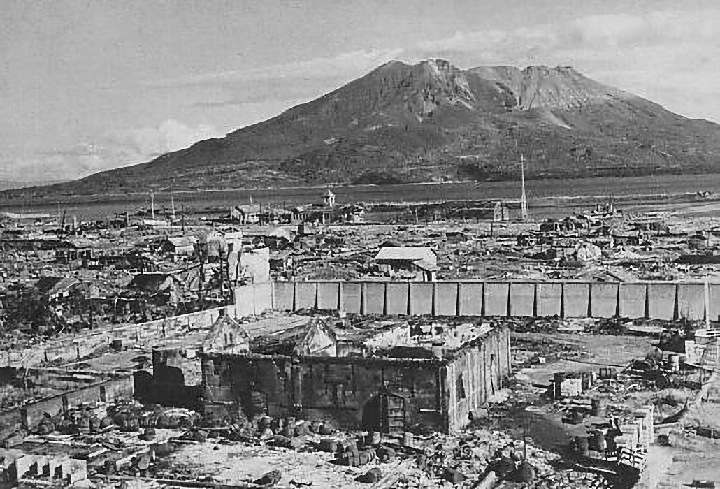
 The bombed out ruins of a Kagoshima residential area with Sakurajima in the background, 1 November 1945

Administrative division
- On August 1, 1934 – the Villages of Yoshino, Nakagōriu and Nishitakeda, all from Kagoshima District, were merged into Kagoshima.[6]
- On October 1, 1950 – the Villages of Ishiki and Higashisakurajima (both from Kagoshima District) were merged into Kagoshima.[6]
- On April 29, 1967 – the Cities of Kagoshima and Taniyama were merged and became city of new Kagoshima.[7]
- On November 1, 2004 – the Towns of Yoshida and Sakurajima (both from Kagoshima District); the Towns of Matsumoto and Koriyama (both from Hioki District); and the town of Kiire (from Ibusuki District) were merged into Kagoshima.
Geography
Kagoshima City is approximately 40 minutes from Kagoshima Airport, and features shopping districts and malls located wide across the city. Transportation options in the city include the Shinkansen (bullet train), local train, city trams, buses, and ferries to-and-from Sakurajima. The large and modern Kagoshima City Aquarium, situated near the Sakurajima Ferry Terminal, was established in 1997 along the docks and offers a direct view of Sakurajima. One of the best places to view the city (and Sakurajima) is from the Amuran Ferris wheel atop of Amu Plaza Kagoshima, and the shopping center attached to the central Kagoshima-Chūō Station. Just outside the city is the early-Edo Period Sengan-en Japanese Garden. The garden was originally a villa belonging to the Shimazu clan and is still maintained by descendants today. Outside the garden grounds is a Satsuma "kiriko" cut glass factory where visitors are welcome to view the glass blowing and cutting processes, and the Shoko Shūseikan Museum, which was built in 1865 and registered as a National Historic Site in 1959. The former Shuseikan industrial complex and the former machine factory were submitted to the UNESCO World Heritage as part of a group list titled Modern Industrial Heritage Sites in Kyushu and Yamaguchi Prefecture.
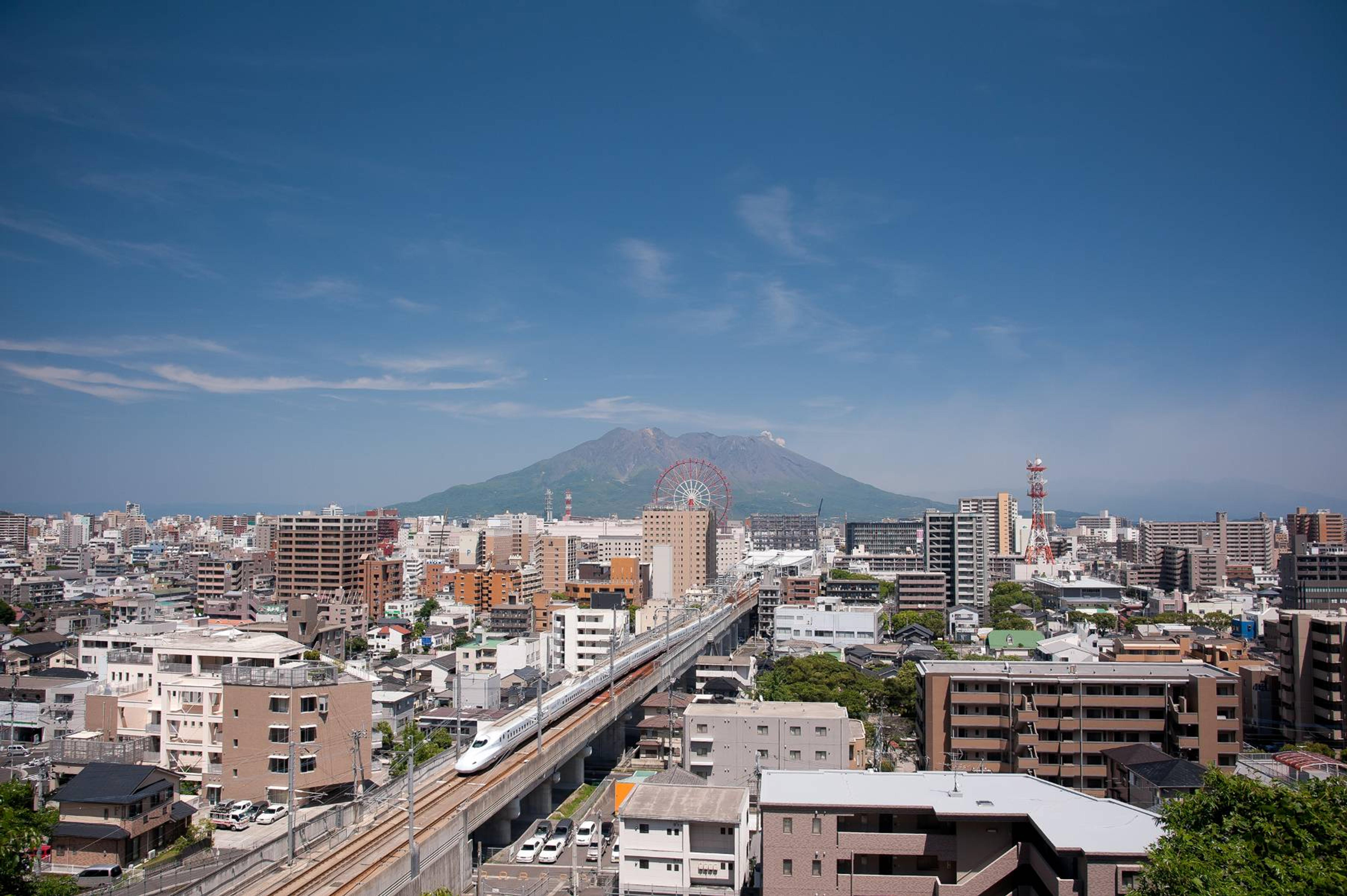
 Sakurajima: a volcano in Kagoshima
 Urban area around the Kagoshima-Chūō Station with Shinkansen (bullet train)
 Kajiyachō Tram Stop with its back to the Kagoshima-Chūō Station Building having ferris wheel
 Tenmonkan shopping arcade
 Kagoshima City Hall Main Building
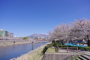 Kotsuki River that runs through Kagoshima City
 Kagoshima City Aquarium and Sakurajima Ferry Terminal
 An image taken from the International Space Station showing Kagoshima and its surroundings on January 10, 2013


Neighboring Municipalities
- Cities: Aira, Hioki, Ibusuki, Minamikyūshū, Minamisatsuma, Satsumasendai, Tarumizu
Climate
Kagoshima has a humid subtropical climate (Köppen climate classification Cfa), possessing the highest year average temperature and winter average temperature in mainland Japan. It is marked by mild, relatively dry winters; warm, humid springs; hot, humid summers; and mild, relatively dry autumns.
| Climate data for Kagoshima (1991−2020 normals, extremes 1883−present) | |||||||||||||
|---|---|---|---|---|---|---|---|---|---|---|---|---|---|
| Month | Jan | Feb | Mar | Apr | May | Jun | Jul | Aug | Sep | Oct | Nov | Dec | Year |
| Record high °C (°F) | 23.9 (75.0) |
24.1 (75.4) |
27.6 (81.7) |
30.2 (86.4) |
31.7 (89.1) |
34.5 (94.1) |
36.6 (97.9) |
37.4 (99.3) |
35.7 (96.3) |
32.4 (90.3) |
29.5 (85.1) |
24.7 (76.5) |
37.4 (99.3) |
| Average high °C (°F) | 13.1 (55.6) |
14.6 (58.3) |
17.5 (63.5) |
21.8 (71.2) |
25.5 (77.9) |
27.5 (81.5) |
31.9 (89.4) |
32.7 (90.9) |
30.2 (86.4) |
25.8 (78.4) |
20.6 (69.1) |
15.3 (59.5) |
23.1 (73.6) |
| Daily mean °C (°F) | 8.7 (47.7) |
9.9 (49.8) |
12.8 (55.0) |
17.1 (62.8) |
21.0 (69.8) |
24.0 (75.2) |
28.1 (82.6) |
28.8 (83.8) |
26.3 (79.3) |
21.6 (70.9) |
16.2 (61.2) |
10.9 (51.6) |
18.8 (65.8) |
| Average low °C (°F) | 4.9 (40.8) |
5.8 (42.4) |
8.7 (47.7) |
12.9 (55.2) |
17.3 (63.1) |
21.3 (70.3) |
25.3 (77.5) |
26.0 (78.8) |
23.2 (73.8) |
18.0 (64.4) |
12.2 (54.0) |
6.9 (44.4) |
15.2 (59.4) |
| Record low °C (°F) | −5.7 (21.7) |
−6.7 (19.9) |
−3.9 (25.0) |
−1.0 (30.2) |
3.9 (39.0) |
9.0 (48.2) |
15.9 (60.6) |
16.5 (61.7) |
9.3 (48.7) |
2.6 (36.7) |
−1.5 (29.3) |
−5.5 (22.1) |
−6.7 (19.9) |
| Average precipitation mm (inches) | 78.3 (3.08) |
112.7 (4.44) |
161.0 (6.34) |
194.9 (7.67) |
205.2 (8.08) |
570.0 (22.44) |
365.1 (14.37) |
224.3 (8.83) |
222.9 (8.78) |
104.6 (4.12) |
102.5 (4.04) |
93.2 (3.67) |
2,434.7 (95.85) |
| Average snowfall cm (inches) | 1 (0.4) |
0 (0) |
0 (0) |
0 (0) |
0 (0) |
0 (0) |
0 (0) |
0 (0) |
0 (0) |
0 (0) |
0 (0) |
1 (0.4) |
2 (0.8) |
| Average precipitation days (≥ 0.5 mm) | 10.2 | 10.2 | 13.2 | 11.1 | 10.7 | 16.9 | 12.8 | 12.2 | 11.3 | 8.0 | 8.9 | 9.9 | 135.4 |
| Average relative humidity (%) | 66 | 65 | 66 | 68 | 71 | 78 | 76 | 74 | 72 | 67 | 68 | 67 | 70 |
| Average dew point °C (°F) | 2 (36) |
4 (39) |
6 (43) |
10 (50) |
15 (59) |
20 (68) |
23 (73) |
24 (75) |
21 (70) |
15 (59) |
10 (50) |
4 (39) |
13 (55) |
| Mean monthly sunshine hours | 132.6 | 139.3 | 163.2 | 175.6 | 178.2 | 109.3 | 185.5 | 206.9 | 176.4 | 184.0 | 157.7 | 143.2 | 1,942.1 |
| Average ultraviolet index | 4 | 5 | 7 | 9 | 10 | 11 | 11 | 11 | 9 | 7 | 4 | 3 | 8 |
| Source 1: Japan Meteorological Agency[8] | |||||||||||||
| Source 2: Weather Atlas (UV),[9] Time and Date[10] | |||||||||||||
| Climate data for Kiire, Kagoshima (1991−2020 normals, extremes 1977−present) | |||||||||||||
|---|---|---|---|---|---|---|---|---|---|---|---|---|---|
| Month | Jan | Feb | Mar | Apr | May | Jun | Jul | Aug | Sep | Oct | Nov | Dec | Year |
| Record high °C (°F) | 23.6 (74.5) |
23.7 (74.7) |
26.7 (80.1) |
29.2 (84.6) |
32.2 (90.0) |
34.5 (94.1) |
36.4 (97.5) |
37.4 (99.3) |
36.5 (97.7) |
33.1 (91.6) |
28.7 (83.7) |
25.5 (77.9) |
37.4 (99.3) |
| Average high °C (°F) | 13.1 (55.6) |
14.5 (58.1) |
17.6 (63.7) |
22.0 (71.6) |
25.7 (78.3) |
27.7 (81.9) |
32.1 (89.8) |
32.9 (91.2) |
30.3 (86.5) |
25.8 (78.4) |
20.5 (68.9) |
15.3 (59.5) |
23.1 (73.6) |
| Daily mean °C (°F) | 8.6 (47.5) |
9.6 (49.3) |
12.5 (54.5) |
16.5 (61.7) |
20.4 (68.7) |
23.6 (74.5) |
27.6 (81.7) |
28.2 (82.8) |
25.5 (77.9) |
20.8 (69.4) |
15.5 (59.9) |
10.5 (50.9) |
18.3 (64.9) |
| Average low °C (°F) | 4.1 (39.4) |
4.9 (40.8) |
7.6 (45.7) |
11.4 (52.5) |
15.6 (60.1) |
20.2 (68.4) |
24.1 (75.4) |
24.6 (76.3) |
21.7 (71.1) |
16.4 (61.5) |
10.8 (51.4) |
6.0 (42.8) |
14.0 (57.1) |
| Record low °C (°F) | −6.3 (20.7) |
−3.6 (25.5) |
−1.4 (29.5) |
2.1 (35.8) |
6.0 (42.8) |
12.1 (53.8) |
17.2 (63.0) |
18.2 (64.8) |
11.5 (52.7) |
5.8 (42.4) |
0.7 (33.3) |
−2.6 (27.3) |
−6.3 (20.7) |
| Average precipitation mm (inches) | 98.9 (3.89) |
136.8 (5.39) |
193.2 (7.61) |
229.9 (9.05) |
231.2 (9.10) |
634.5 (24.98) |
385.2 (15.17) |
228.2 (8.98) |
249.8 (9.83) |
115.0 (4.53) |
126.4 (4.98) |
107.5 (4.23) |
2,765.7 (108.89) |
| Average precipitation days (≥ 1.0 mm) | 10.2 | 10.2 | 12.9 | 10.7 | 10.5 | 16.8 | 12.6 | 11.6 | 11.0 | 7.9 | 8.5 | 9.5 | 132.4 |
| Mean monthly sunshine hours | 123.8 | 133.1 | 161.7 | 183.1 | 182.1 | 107.3 | 192.4 | 220.1 | 173.9 | 181.1 | 151.8 | 132.7 | 1,938.2 |
| Source: Japan Meteorological Agency[11][12] | |||||||||||||
See or edit raw graph data.
Demographics
As of 1 January 2020, Kagoshima City has an estimated population of 595,049 and a population density of 1,087 persons per km2. The total area is 547.58 km2 (211 sq mi). According to the April 2014 issue of the Kagoshima Prefectural Summary by the Kagoshima Prefecture Department of Planning and Promotion, the population of the prefecture at large was 1,680,319. The city's total area nearly doubled between 2003 and 2005 as a result of five towns: the towns of Kōriyama and Matsumoto (both from Hioki District) the town of Kiire (from Ibusuki District) and the towns of Sakurajima and Yoshida (both from Kagoshima District). All areas were merged into Kagoshima City on 1 November 2004.
|
|
| ||||||||||||||||||||||||||||||||||||||||||||||||
| Kagoshima population statistics[13] | ||||||||||||||||||||||||||||||||||||||||||||||||||
Points of interest
- Ishibashi Park
- Kagoshima City Aquarium
- Kagoshima Botanical Garden
- Museum of the Meiji Restoration
- Sengan-en Garden
Education
Universities and Colleges
- Kagoshima University
- The International University of Kagoshima
- Shigakukan University
- Kagoshima Prefectural College
- Kagoshima Immaculate Heart College
- Kagoshima Women's College
High schools
- Kagoshima Prefectural Konan High School
- Kagoshima Prefectural Tsurumaru High School
- La Salle Junior and Senior High School
etc.
Transportation


Railways
All lines are operated by Kyushu Railway Company (JR Kyushu)
- Kyushu Shinkansen
- Kagoshima Main Line
- Satsuma-Matsumoto Station – Kami-Ijuin Station – Hiroki Station – Kagoshima-Chuo Station – Kagoshima Station
- Nippo Main Line
- Ryugamizu Station – Kagoshima Station
- Ibusuki Makurazaki Line
- Kagoshima-Chuo Station – Korimoto Station – Minami-Kagoshima Station – Usuki Station – Taniyama Station – Jigenji Station – Sakanoue Station – Goino Station – Hirakawa Station – Sesekushi Station – Nakamyo Station – Kiire Station – Maenohama Station – Nukumi Station
Tramway
- Kagoshima City Transportation Bureau Taniyama Line
- Kagoshima City Transportation Bureau Korimoto Line
Highways
- National Route 3
- National Route 10
- National Route 58
- National Route 224
- National Route 225
- National Route 226
- National Route 328
- Kyushu Expressway
- Minamikyushu Expressway
- Ibusuki Skyline
Bus
- Kagoshima City Bus
- Kagoshima Kotsu
- Iwasaki Bus Network
- Nangoku Kotsu
- JR Kyushu bus
- MTA Bus
Ferry/Jetfoil
- Sakurajima Ferry
- A Line (to southern islands)
- Marix Line (to southern islands)
- RKK Line (to Okinawa, cargo only)
- Toppy (to Tanegashima and Yakushima)
- Seahawk (to Koshikijima Islands)
Airport
Kagoshima Airport in Kirishima (35 km (22 miles) NE of Kagoshima)
Sports
Kagoshima was one of the host cities of the official 1998 Women's Volleyball World Championship. Kagoshima is home to Kagoshima United. They play their home games at Kagoshima Kamoike Stadium.
Sister cities and friendship cities
Kagoshima is twinned with:[14]
 Naples Street in Kagoshima
 Perth Street in Kagoshima
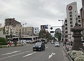 Miami Street in Kagoshima
 Kyogetsu-Tei in Kagoshima commemorating the friendship city relationship with Changsha


Notable people
- Akitsune Imamura – Japanese seismologist
- Bernardo the Japanese – Japanese Christian convert, disciple of Saint Francis Xavier, and first Japanese to set foot in Europe
- Emi Hashino – Japanese comedian
- Hiroko Ōta – Japanese politician, economic researcher
- Hiroshi Kawauchi – Japanese politician
- Ikki Sawamura – Japanese model, actor, TV presenter
- Izumi Inamori – Japanese actress
- Junichi Miyashita – Japanese swimmer
- Kabayama Sukenori – Japanese samurai military leader and statesman
- Kaneta Kimotsuki – Japanese voice actor (1935–2016)
- Kazuo Inamori – Japanese philanthropist, entrepreneur, founder of Kyocera Corporation and KDDI Corporation, and chairman of Japan Airlines
- Kawasaki Shōzō – Industrialist, founder of the Kawasaki Heavy Industries and K Line groups
- Kōhei Miyauchi – Japanese actor
- Koji Maeda – Japanese football player
- Kiyotaka Kuroda – Japanese politician, second Prime Minister of Japan
- Miyo Yoshida – Japanese professional boxer
- Mone Kamishiraishi – Japanese singer and actress
- Morihiko Nakahara – Japanese conductor
- Norihiro Nakajima – Japanese manga artist of Astro Team, etc.
- Ryuji Fujiyama – Japanese football player
- Saigō Takamori – Japanese politician, samurai
- Sakura Miyawaki – Japanese idol singer and actress, member of Le Sserafim
- Saori Sakoda – Japanese volleyball player
- Seiki Kuroda – Japanese artist
- Shinobu Kaitani – Japanese manga artist
- Taisei Okazaki – Japanese DJ & music producer
- Takuya Shiihara – Japanese football player
- Toru Kamikawa – Japanese football referee
- Toshimichi Ōkubo – Japanese statesman, samurai, and one of the Three Great Nobles who led to the Meiji Restoration
- Yasuhito Endō – Japanese football player
- Yoshito Kajiya – Japanese politician
- Yuki Kashiwagi – Japanese idol singer
- Yuya Hikichi – Japanese football player
See also
- 1993 Kagoshima Heavy Rain
- Kagoshima ramen
- Sakurajima daikon
- Godzilla vs. Spacegodzilla
References
- "「鹿児島市の生い立ち」 - 鹿児島市公式webサイト (Kagoshima City official website)" (in Japanese). 2020-09-28. Retrieved 2021-09-22.
- Blacker, Carmen; Cortazzi, Hugh (1 September 1999). Collected Writings of Modern Western Scholars on Japan: Carmen Blacker, Hugh Cortazzi and Ben-Ami Shillony. Psychology Press. ISBN 9781873410967 – via Google Books.
- "Kagoshima", Illustrated London News. 24 January 1914.
- "JLect - かごっま・かごんま・かごいま・かごひま【鹿児島】 : kagomma · kagonma · kagoima · kagohima | define meaning". www.jlect.com. Retrieved 2020-10-14.
- Headquarters, XXI Bomber Command APO 234, "Tactical Mission Report Mission No. 206-209." June 18, 1945.
- 角川日本地名大辞典 46 鹿児島県 p.678
- 角川日本地名大辞典 46 鹿児島県 p.417
- 気象庁 / 平年値(年・月ごとの値). Japan Meteorological Agency. Retrieved May 19, 2021.
- "Kagoshima, Japan – Detailed climate information and monthly weather forecast". Weather Atlas. Retrieved 4 August 2022.
- "Climate & Weather Averages at Kagoshima weather station". Time and Date. Retrieved 4 August 2022.
- 観測史上1~10位の値(年間を通じての値). JMA. Retrieved March 28, 2022.
- 気象庁 / 平年値(年・月ごとの値). JMA. Retrieved March 28, 2022.
- Kagoshima population statistics
- "姉妹・友好・兄弟・協定都市". city.kagoshima.lg.jp (in Japanese). Kagoshima. Retrieved 2020-12-10.
- Amu Plaza Visitors Guide (2006) available in Amu Plaza, Chūō Station, Kagoshima, Japan
- 角川日本地名大辞典 46 鹿児島県. Kadokawa Shoten. 1983-03-08. ISBN 4-04-001460-X.
External links
 Geographic data related to Kagoshima at OpenStreetMap
- Kagoshima City official website (in Japanese)
- Kagoshima Visitor's Guide from the Kagoshima Internationalization Council
Kagoshima (capital) | |||||||||||
| Core city | |||||||||||
| Cities |
| ||||||||||
| Districts |
| ||||||||||
List of mergers in Kagoshima Prefecture | |||||||||||
| 2,000,000 and more | |
|---|---|
| 1,000,000–1,999,999 | |
| 500,000–999,999 | |
| 200,000–499,999 |
|
Authority control | |
|---|---|
| General | |
| National libraries | |
| Scientific databases | |
| Other |
|
На других языках
[de] Kagoshima
Kagoshima (jap. 鹿児島市, -shi; im Deutschen auch Kagoschima) ist eine japanische Hafenstadt an der Südwestspitze der Insel Kyūshū. Sie ist Verwaltungssitz der Präfektur Kagoshima.- [en] Kagoshima
[es] Kagoshima
La ciudad de Kagoshima (鹿児島市, Kagoshima-shi?) es la ciudad capital de la prefectura de Kagoshima, sobre la región de Kyushu en la isla de Kyushu, al suroeste de Japón. Se estimaba que el 1 de enero de 2005 la ciudad tenía 605 650 habitantes, lo que representa una densidad de población de 1107,81 personas por km². Su extensión es de 546,71 km². La ciudad es apodada "Nápoles de Oriente" por su localización en una bahía (Caldera Aira), el clima templado y el estratovolcán Sakurajima, parecido al Vesubio.[ru] Кагосима
Каго́сима[1][2] (яп. 鹿児島市 Кагосима-си) — город в Японии, имеющий статус «центральный город», административный центр и крупнейший населённый пункт префектуры Кагосима. За расположение на берегу залива у подножия стратовулкана Сакурадзима, а также за жаркий климат город часто называют «Неаполем Востока».Другой контент может иметь иную лицензию. Перед использованием материалов сайта WikiSort.org внимательно изучите правила лицензирования конкретных элементов наполнения сайта.
WikiSort.org - проект по пересортировке и дополнению контента Википедии