world.wikisort.org - Japan
Kanoya (鹿屋市, Kanoya-shi) is a city in Kagoshima Prefecture, Japan. It is located in the southeastern Kyushu region in the central part of Ōsumi Peninsula.
This article needs additional citations for verification. (November 2015) |
Kanoya
鹿屋市 | |
|---|---|
City | |
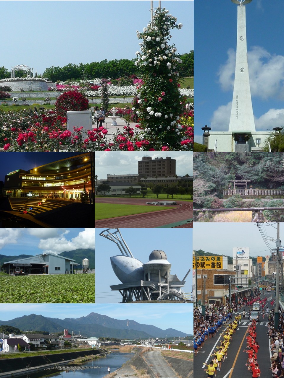 Top left: Kanoya Rose Park, Top right: Kushira Memorial Tower, 2nd left: Kanoya Ring City, 2nd middle: Kanoya University of Physical Education, 2nd right: Mount Aira Tomb, 3rd left: Kasanohara Plateau, 3rd middle: Kihoku Celestial Sphere Museum, Bottom left :Kimotsuki River and Mount Takakuma, Bottom right: Kanoya Summer Festival | |
|
Flag Emblem | |
 Location of Kanoya in Kagoshima Prefecture | |
 Kanoya Location in Japan | |
| Coordinates: 31°22′59″N 130°51′7″E | |
| Country | Japan |
| Region | Kyushu |
| Prefecture | Kagoshima Prefecture |
| Government | |
| • Mayor | Shigeru Nakanishi |
| Area | |
| • Total | 448.33 km2 (173.10 sq mi) |
| Population (March 2015) | |
| • Total | 104,148 |
| • Density | 232/km2 (600/sq mi) |
| Time zone | UTC+09:00 (JST) |
| City hall address | 20-1 Kyōeichō, Kanoya-shi, Kagoshima-ken 893-8501 |
| Climate | Cfa |
| Website | www |
| Symbols | |
| Flower | Rose |
| Tree | Camphor laurel |
Kanoya is the most populous city in Japan without any connection to railway services, after the abolition of the Ōsumi Line in 1987.[1]
Geography
Kanoya is located approximately at the heart of Ōsumi Peninsula with its city limits running approximately 20 kilometres (12 mi) east and west and 41 kilometres (25 mi) north and south. The Takakuma Mountains stretch out into the northwestern part of the city and the Kimotsuki Mountains in the southeast. Between both mountain ranges lie the Kasanohara and Kanoyahara plateaus. The Kimotsuki Plains spread through the alluvial plains of the Kimotsuki River that runs through central Kanoya. In the western part of the city is Kinko Bay which runs down the coast line.
Bordering municipalities
Kanoya is bordered by the cities of Tarumizu, Kirishima, and Soo, the towns of Higashikushira, Kinko, and Kimotsuki in Kimotsuki District, and the town of Osaki in Soo District.
 View of downtown Kanoya from Kanoya City Hall
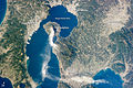 An image taken from the International Space Station showing Kanoya and its surroundings on January 10, 2013


Climate
Kanoya has a humid subtropical climate (Köppen climate classification Cfa) with hot summers and mild winters. Precipitation is significant throughout the year, and is heavier in summer, especially the months of June and July. The average annual temperature in Kanoya is 17.3 °C (63.1 °F).[2] The average annual rainfall is 2,685.6 mm (105.73 in) with June as the wettest month. The temperatures are highest on average in August, at around 27.5 °C (81.5 °F), and lowest in January, at around 7.5 °C (45.5 °F).[3] Its record high is 37.6 °C (99.7 °F), reached on 18 August 2020, and its record low is −8.0 °C (17.6 °F), reached on 25 January 2016.[4]
| Climate data for Kanoya (1991−2020 normals, extremes 1977−present) | |||||||||||||
|---|---|---|---|---|---|---|---|---|---|---|---|---|---|
| Month | Jan | Feb | Mar | Apr | May | Jun | Jul | Aug | Sep | Oct | Nov | Dec | Year |
| Record high °C (°F) | 22.7 (72.9) |
23.6 (74.5) |
25.9 (78.6) |
29.6 (85.3) |
33.0 (91.4) |
34.2 (93.6) |
35.8 (96.4) |
37.6 (99.7) |
35.2 (95.4) |
33.0 (91.4) |
28.5 (83.3) |
24.6 (76.3) |
37.6 (99.7) |
| Average high °C (°F) | 12.8 (55.0) |
14.2 (57.6) |
17.0 (62.6) |
21.3 (70.3) |
25.1 (77.2) |
26.9 (80.4) |
31.3 (88.3) |
32.1 (89.8) |
29.7 (85.5) |
25.4 (77.7) |
20.2 (68.4) |
15.0 (59.0) |
22.6 (72.7) |
| Daily mean °C (°F) | 7.5 (45.5) |
8.8 (47.8) |
11.8 (53.2) |
16.0 (60.8) |
20.0 (68.0) |
23.0 (73.4) |
27.0 (80.6) |
27.5 (81.5) |
24.9 (76.8) |
20.0 (68.0) |
14.5 (58.1) |
9.4 (48.9) |
17.5 (63.6) |
| Average low °C (°F) | 1.9 (35.4) |
3.0 (37.4) |
6.3 (43.3) |
10.4 (50.7) |
15.1 (59.2) |
19.7 (67.5) |
23.6 (74.5) |
23.9 (75.0) |
21.0 (69.8) |
15.1 (59.2) |
8.9 (48.0) |
3.5 (38.3) |
12.7 (54.9) |
| Record low °C (°F) | −8.0 (17.6) |
−6.8 (19.8) |
−4.4 (24.1) |
−1.0 (30.2) |
3.7 (38.7) |
9.1 (48.4) |
15.5 (59.9) |
17.0 (62.6) |
9.3 (48.7) |
1.2 (34.2) |
−3.5 (25.7) |
−6.6 (20.1) |
−8.0 (17.6) |
| Average precipitation mm (inches) | 80.3 (3.16) |
119.2 (4.69) |
173.2 (6.82) |
196.9 (7.75) |
219.8 (8.65) |
623.0 (24.53) |
425.6 (16.76) |
282.9 (11.14) |
288.2 (11.35) |
138.3 (5.44) |
100.6 (3.96) |
77.5 (3.05) |
2,685.6 (105.73) |
| Average precipitation days (≥ 1.0 mm) | 8.7 | 9.3 | 12.8 | 11.1 | 10.6 | 17.2 | 12.3 | 12.5 | 11.3 | 7.9 | 8.6 | 7.2 | 129.5 |
| Mean monthly sunshine hours | 151.5 | 152.1 | 167.5 | 176.6 | 173.2 | 99.6 | 183.7 | 202.0 | 161.1 | 176.9 | 157.6 | 156.6 | 1,961.7 |
| Source: Japan Meteorological Agency[4][3] | |||||||||||||
| Climate data for Kihoku, Kanoya (1991−2020 normals, extremes 1977−present) | |||||||||||||
|---|---|---|---|---|---|---|---|---|---|---|---|---|---|
| Month | Jan | Feb | Mar | Apr | May | Jun | Jul | Aug | Sep | Oct | Nov | Dec | Year |
| Record high °C (°F) | 20.7 (69.3) |
21.2 (70.2) |
24.2 (75.6) |
27.9 (82.2) |
31.4 (88.5) |
36.0 (96.8) |
34.7 (94.5) |
36.4 (97.5) |
33.9 (93.0) |
30.9 (87.6) |
29.4 (84.9) |
21.5 (70.7) |
36.4 (97.5) |
| Average high °C (°F) | 9.9 (49.8) |
11.4 (52.5) |
14.6 (58.3) |
19.3 (66.7) |
23.3 (73.9) |
25.2 (77.4) |
29.4 (84.9) |
30.1 (86.2) |
27.5 (81.5) |
22.9 (73.2) |
17.5 (63.5) |
12.1 (53.8) |
20.3 (68.5) |
| Daily mean °C (°F) | 5.8 (42.4) |
6.9 (44.4) |
9.8 (49.6) |
14.2 (57.6) |
18.3 (64.9) |
21.3 (70.3) |
25.2 (77.4) |
25.5 (77.9) |
22.8 (73.0) |
18.1 (64.6) |
12.9 (55.2) |
7.9 (46.2) |
15.7 (60.3) |
| Average low °C (°F) | 1.9 (35.4) |
2.6 (36.7) |
5.4 (41.7) |
9.6 (49.3) |
14.1 (57.4) |
18.2 (64.8) |
22.1 (71.8) |
22.3 (72.1) |
19.4 (66.9) |
14.2 (57.6) |
8.7 (47.7) |
3.7 (38.7) |
11.8 (53.3) |
| Record low °C (°F) | −8.3 (17.1) |
−7.1 (19.2) |
−3.1 (26.4) |
0.2 (32.4) |
3.3 (37.9) |
11.3 (52.3) |
14.2 (57.6) |
16.4 (61.5) |
10.1 (50.2) |
3.4 (38.1) |
−2.1 (28.2) |
−5.2 (22.6) |
−8.3 (17.1) |
| Average precipitation mm (inches) | 87.1 (3.43) |
131.9 (5.19) |
192.3 (7.57) |
230.9 (9.09) |
258.2 (10.17) |
676.2 (26.62) |
460.5 (18.13) |
298.0 (11.73) |
325.7 (12.82) |
136.1 (5.36) |
112.5 (4.43) |
92.6 (3.65) |
3,001.9 (118.19) |
| Average precipitation days (≥ 1.0 mm) | 8.9 | 9.5 | 13.1 | 11.5 | 11.4 | 17.5 | 13.7 | 13.5 | 12.4 | 8.3 | 8.7 | 8.2 | 136.7 |
| Mean monthly sunshine hours | 141.8 | 141.9 | 163.9 | 167.2 | 166.3 | 86.1 | 149.8 | 164.3 | 138.7 | 168.1 | 151.4 | 145.2 | 1,795.6 |
| Source: Japan Meteorological Agency[5][6] | |||||||||||||
Demographics
As of 1 March 2015[update], the city has an estimated population of 104,148.[7] Within Kagoshima Prefecture, Kanoya is the third most populous city next to Kagoshima (the prefectural capital) and Kirishima.
In 2006, the original city of Kanoya was expanded following the merger of the two towns of Aira and Kushira in Kimotsuki District, and Kihoku in Soo District.[8] The original Kanoya City was established as a municipality on May 27, 1941 (Navy Memorial Day).[citation needed]
Kanoya is also popularly called the "Town of Roses".[9]
| Year | Pop. | ±% |
|---|---|---|
| 1920 | 60,487 | — |
| 1925 | 62,899 | +4.0% |
| 1930 | 69,982 | +11.3% |
| 1935 | 73,944 | +5.7% |
| 1940 | 79,716 | +7.8% |
| 1945 | 104,880 | +31.6% |
| 1950 | 107,579 | +2.6% |
| 1955 | 114,804 | +6.7% |
| 1960 | 109,662 | −4.5% |
| 1965 | 103,358 | −5.7% |
| 1970 | 95,915 | −7.2% |
| 1975 | 94,790 | −1.2% |
| 1980 | 100,005 | +5.5% |
| 1985 | 102,653 | +2.6% |
| 1990 | 103,761 | +1.1% |
| 1995 | 105,059 | +1.3% |
| 2000 | 106,462 | +1.3% |
| 2005 | 106,208 | −0.2% |
| 2010 | 105,086 | −1.1% |
| 2015 | 103,608 | −1.4% |
| 2020 | 101,096 | −2.4% |
| Kanoya population statistics[10] | ||
Specialties
Kanoya's specialties include Berkshire pig, peanuts, broilers, and sweet potatoes. Kanoya is home to the Kanoya National Institute of Fitness and Sports (NIFS), as well as the Japan Maritime Self-Defense Force Kanoya Air Base (JMSDF Kanoya Air Field).
Education
- National Institute of Fitness and Sports in Kanoya
Notable people from Kanoya, Kagoshima
- Sunshine Ikezaki (Real Name: Satoru Ikezaki, Nihongo: 池崎 慧, Ikezaki Satoru), Japanese comedian
- Yuka Nishida (Nihongo: 西田 優香, Nishida Yuka), Japanese judoka
- Sayuri Kokushō (Nihongo: 国生さゆり or 國生さゆり, Kokusho Sayuri), Japanese actress, singer, and tarento
- Taiga Satoru (Real Name: Satoshi Kawasaki, Nihongo: 川崎悟司, Kawasaki Satoshi), Japanese sumo wrestler
- Yamato Maeda (Nihongo: 前田 大和, Maeda Yamato), Japanese professional baseball outfielder (Yokohama DeNA BayStars, Nippon Professional Baseball)
- Sakura Yokomine (Nihongo: 横峯さくら, Yokomine Sakura), Japanese professional golfer (LPGA Tour and LPGA of Japan Tour)
References
- "鉄道のない市 人口ベスト10". Archived from the original on 2018-10-10. Retrieved 2018-08-08.
- "鹿児島県 鹿屋の気温、降水量、観測所情報". Weather.time-j.net. Retrieved 2015-11-20.
- 気象庁 / 平年値(年・月ごとの値). JMA. Retrieved March 26, 2022.
- 観測史上1~10位の値(年間を通じての値). JMA. Retrieved March 26, 2022.
- 観測史上1~10位の値(年間を通じての値). JMA. Retrieved March 26, 2022.
- 気象庁 / 平年値(年・月ごとの値). JMA. Retrieved March 26, 2022.
- "鹿屋市(かのや市)|鹿屋市の統計 人口". E-kanoya.net. Retrieved 2015-11-20.
- Kanoya Merger
- "鹿屋市(かのや市)|ばらのまち かのや ポータルページ". E-kanoya.net. Retrieved 2015-11-20.
- Kanoya population statistics
External links
- Official website
 (in Japanese)
 - Kanoya International Exchange Association (in English)
 Geographic data related to Kanoya, Kagoshima at OpenStreetMap
Kagoshima (capital) | |||||||||||
| Core city | |||||||||||
| Cities |
| ||||||||||
| Districts |
| ||||||||||
List of mergers in Kagoshima Prefecture | |||||||||||
Authority control | |
|---|---|
| General | |
| National libraries | |
| Scientific databases | |
| Other |
|
На других языках
[de] Kanoya
Kanoya (jap. .mw-parser-output .Hani{font-size:110%}鹿屋市, -shi) ist eine japanische Stadt in der Präfektur Kagoshima auf der Ōsumi-Halbinsel am Ostufer der Kagoshima-Bucht.- [en] Kanoya, Kagoshima
[ru] Каноя
Каноя (яп. 鹿屋市 Каноя-си) — город в Японии, находящийся в префектуре Кагосима. Площадь города составляет 448,33 км²[1], население — 103 875 человек (1 августа 2014)[2], плотность населения — 231,69 чел./км².Другой контент может иметь иную лицензию. Перед использованием материалов сайта WikiSort.org внимательно изучите правила лицензирования конкретных элементов наполнения сайта.
WikiSort.org - проект по пересортировке и дополнению контента Википедии