world.wikisort.org - Japan
Ibusuki (指宿市, Ibusuki-shi) is a city located in Kagoshima Prefecture, Japan, founded on April 1, 1954. In March 1, 2012, the city had an estimated population of 43,931, with 19,119 households and a population density of 294.82 persons per km2. However the census of 2020 confirmed a population decline to 39,011 [2][3] and by October 2022 there were only 17,537 households . The total area is 148.81 km2 (57.46 sq mi) and shares a border with Ei, a town to its north.
Ibusuki
指宿市 | |
|---|---|
City | |
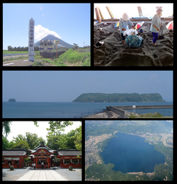 Ibusuki City Montage | |
|
Flag Emblem | |
Location of Ibusuki in Kagoshima Prefecture | |
 Ibusuki Location in Japan | |
| Coordinates: 31°15′10″N 130°37′59″E | |
| Country | Japan |
| Region | Kyushu |
| Prefecture | Kagoshima Prefecture |
| First official recorded | 702 AD |
| City settled | April 1, 1954 |
| Government | |
| • Mayor | Akashi Uchikoshi (from February 2022) [1] |
| Area | |
| • Total | 148.81 km2 (57.46 sq mi) |
| as of July 1, 2021[2] | |
| Population (2020 census) | |
| • Total | 39,011 [2][3] |
| • Estimate (October 1, 2022 [1]) | 37,760 [1] |
| • Density | 294.82/km2 (763.6/sq mi) |
| Time zone | UTC+09:00 (JST) |
| City hall address | 2424 Jutchō, Ibusuki-shi, Kagoshima-ken 891-0497 |
| Climate | Cfa |
| Website | www |
| Symbols | |
| Bird | Japanese white-eye |
| Fish | Skipjack tuna |
| Butterfly | Great orange tip |
| Flower | Hibiscus and rapeseed |
| Tree | Japanese box and sacred garlic pear |
On January 1, 2006, the towns of Kaimon and Yamagawa (both from Ibusuki District) were merged into Ibusuki.
Ibusuki can be accessed by Routes 226 and 269 and the Ibusuki Skyline drive. The city's main railroad station is Ibusuki Station.
Ibusuki is famous for black-sand spas known as sunamushi onsen and the fine noodle sōmen nagashi.[2]
Ibusuki has a sister city relationship with Rockhampton, Queensland, Australia.


Geography
Points of interest include:[1]
- Kirishima-Kinkowan National Park contains in its Kagoshima Bay region:
- Kaimondake volcano[2]
- An inactive stratovolcano at the end of the Satsuma Peninsula
- Chiringashima[2]
- Island in Kagoshima Bay
- Lake Ikeda[2]
- A volcanic Caldera
- Kaimondake volcano[2]
- Tōsenkyō
- Ryūgū Shrine
The city includes the following districts from the west:
- Kaimonjutcho
- The northern aspect of Mount Kaimon and adjacent sea coast of Satsuma Peninsula
- Kaimonkawashiri
- The southern aspect Mount Kaimon and adjacent sea coast of Satsuma Peninsula
- Kaimonsenta
- From Kaimonjutcho and Kaimonkawashiri to Lake Ikeda
- Ikeda
- Northern Lake Ikeda to the west
- Iwamoto
- North of Ikeda to the west coast at Kagoshima Bay
- Komaki
- regions north west of Iwamoto to the west coast at Kagoshima Bay
- Yamagawaokachogamizu
- The coast including Cape Nagasakibana at the entrance to Kagoshima Bay
- Kaimonueno
- From Lake Ikeda towards the south
- Yamagawatoshinaga
- Adjacent to eastern shore Lake Ikeda
- Yamagawaoyama
- to the west of Yamagawaogawa from Nishi-Ōyama rail station to Lake Unagi
- Yamagawaogawa
- extends from near the sea almost to Lake Unagi a volcanic crater
- Yamagawanarikawa
- Surrounds of Lake Unagi to the northern aspects Yamagawa harbour
- Nishikata
- from west of Lake Unagi to Kagoshima Bay including the land corridor to Ibusuki
- Higashikata
- Rural north of Lake Unagi almost to the coast of Kagoshima Bay missing the main land corridor to Ibusuki and includes Chiringashima
- Yamagawafukumoto
- coast at entrance to Kagoshima Bay and includes southern aspects Yamagawa harbour
- Yamagawaasahicho
- coastal in Yamagawa harbour within Kagoshima Bay
- Shinnishikata
- Northern inland area
- Junicho
- Almost from Lake Unagi to the east, mainly inland but reaching the coast at northern aspect Yamagawa harbour
- Omure
- Central Ibusuki to the north and reaching Kagoshima Bay
- Minato
- Central Ibusuki to the north and reaching Kagoshima Bay
Yunohama
- South of Ibusukifrom railway to coast of Kagoshima Bay
- Kiirenukumicho
- North of Komaki along the coast of Kagoshima Bay
- Yamagawayamashitacho
Geology
The city has many volcanoes and hot springs of the Ibusuki Volcanic Field. The Yamagawa Binary Power Station uses local geothermal power to contribute a maximum of 4990 kW as a "green energy" source.[4]
Climate
Ibusuki has a humid subtropical climate (Köppen climate classification Cfa) with hot summers and mild winters. Precipitation is significant throughout the year, and is heavier in summer, especially the months of June and July. The average annual temperature in Ibusuki is 18.3 °C (64.9 °F). The average annual rainfall is 2,602.1 mm (102.44 in) with June as the wettest month. The temperatures are highest on average in August, at around 28.1 °C (82.6 °F), and lowest in January, at around 8.7 °C (47.7 °F).[5] Its record high is 36.8 °C (98.2 °F), reached on 18 August 2020, and its record low is −3.4 °C (25.9 °F), reached on 25 January 2016.[6] Due to its marine subtropical climate, the city is the northern limit in Japan where cycads grow naturally.[2]
| Climate data for Ibusuki (1991−2020 normals, extremes 1977−present) | |||||||||||||
|---|---|---|---|---|---|---|---|---|---|---|---|---|---|
| Month | Jan | Feb | Mar | Apr | May | Jun | Jul | Aug | Sep | Oct | Nov | Dec | Year |
| Record high °C (°F) | 23.5 (74.3) |
24.0 (75.2) |
26.4 (79.5) |
28.7 (83.7) |
32.4 (90.3) |
33.2 (91.8) |
35.5 (95.9) |
36.8 (98.2) |
35.2 (95.4) |
33.5 (92.3) |
29.0 (84.2) |
24.3 (75.7) |
36.8 (98.2) |
| Average high °C (°F) | 13.2 (55.8) |
14.5 (58.1) |
17.5 (63.5) |
21.9 (71.4) |
25.6 (78.1) |
27.6 (81.7) |
31.7 (89.1) |
32.6 (90.7) |
30.1 (86.2) |
25.6 (78.1) |
20.4 (68.7) |
15.3 (59.5) |
23.0 (73.4) |
| Daily mean °C (°F) | 8.7 (47.7) |
9.8 (49.6) |
12.6 (54.7) |
16.5 (61.7) |
20.4 (68.7) |
23.6 (74.5) |
27.5 (81.5) |
28.1 (82.6) |
25.5 (77.9) |
20.8 (69.4) |
15.7 (60.3) |
10.8 (51.4) |
18.3 (65.0) |
| Average low °C (°F) | 4.5 (40.1) |
5.2 (41.4) |
7.8 (46.0) |
11.5 (52.7) |
15.7 (60.3) |
20.3 (68.5) |
24.2 (75.6) |
24.7 (76.5) |
21.8 (71.2) |
16.7 (62.1) |
11.4 (52.5) |
6.6 (43.9) |
14.2 (57.6) |
| Record low °C (°F) | −3.4 (25.9) |
−3.0 (26.6) |
−1.6 (29.1) |
0.9 (33.6) |
6.9 (44.4) |
11.8 (53.2) |
17.0 (62.6) |
17.6 (63.7) |
12.6 (54.7) |
6.5 (43.7) |
2.7 (36.9) |
−1.8 (28.8) |
−3.4 (25.9) |
| Average precipitation mm (inches) | 93.0 (3.66) |
133.4 (5.25) |
192.2 (7.57) |
232.3 (9.15) |
237.9 (9.37) |
592.0 (23.31) |
352.8 (13.89) |
204.1 (8.04) |
239.2 (9.42) |
107.4 (4.23) |
120.3 (4.74) |
97.5 (3.84) |
2,602.1 (102.44) |
| Average precipitation days (≥ 1.0 mm) | 9.3 | 9.9 | 12.6 | 10.7 | 10.3 | 16.1 | 11.0 | 10.5 | 11.0 | 7.7 | 8.4 | 8.6 | 126.1 |
| Mean monthly sunshine hours | 123.0 | 134.1 | 158.5 | 175.8 | 176.3 | 105.7 | 196.6 | 221.2 | 177.3 | 182.0 | 153.0 | 136.1 | 1,938.3 |
| Source: Japan Meteorological Agency[6][5] | |||||||||||||
Demographics
Per Japanese census data, the population of Ibusuki in 2020 is 39,011 people.[3] Since the census began in Ibusuki in 1950, the town's population has been slowly declining, with no signs of picking up until 2020 but the latest data suggests further decline.[1]
| Year | Pop. | ±% |
|---|---|---|
| 1950 | 67,977 | — |
| 1955 | 66,420 | −2.3% |
| 1960 | 63,118 | −5.0% |
| 1965 | 59,615 | −5.5% |
| 1970 | 55,832 | −6.3% |
| 1975 | 55,282 | −1.0% |
| 1980 | 55,140 | −0.3% |
| 1985 | 54,781 | −0.7% |
| 1990 | 52,292 | −4.5% |
| 1995 | 50,529 | −3.4% |
| 2000 | 48,750 | −3.5% |
| 2005 | 46,822 | −4.0% |
| 2010 | 44,401 | −5.2% |
| 2015 | 41,831 | −5.8% |
| 2020 | 39,011 | −6.7% |
| Ibusuki population statistics[3] | ||
Culture
- Hirasaki Shrine
- Iwasaki Art Museum
- Ibusuki Onsen
- Ibusuki Experimental Botanical Garden
Transport
- Higashi-Kaimon Station
- Ibusuki Station
- Irino Station
- Kaimon Station
- Miyagahama Station
- Nigatsuden Station
- Nishi-Ōyama Station
- Ōyama Station
- Satsuma-Imaizumi Station
- Satsuma-Kawashiri Station
- Yamakawa Station
Twin Cities
- Chitose in Hokkaidō
- Rockhampton in Australia
References
- "Ibusuki City official website (in Japanese)". Retrieved 2022-10-05.
- "About Ibusuki City (in Japanese)". Retrieved 2022-10-05.
- Ibusuki population statistics
- Kondo, Saki; Oyama, Hiroshi; Yamada, Shigeto (2019). "Yamagawa Binary Power Station Geothermal ORC plant in Japan" (PDF). GRC Transactions. 43.
- 気象庁 / 平年値(年・月ごとの値). JMA. Retrieved March 27, 2022.
- 観測史上1~10位の値(年間を通じての値). JMA. Retrieved March 27, 2022.
External links
- Ibusuki City official website (in Japanese)
- Kagoshima Prefectural Visitors Bureau official website (in English)
 Ibusuki travel guide from Wikivoyage
- Photos of the sand baths at Ibusuki and area attractions
Kagoshima (capital) | |||||||||||
| Core city | |||||||||||
| Cities |
| ||||||||||
| Districts |
| ||||||||||
List of mergers in Kagoshima Prefecture | |||||||||||
(in Japanese)
This Kagoshima Prefecture location article is a stub. You can help Wikipedia by expanding it. |
На других языках
[de] Ibusuki
Ibusuki (japanisch 指宿市, -shi) ist eine Stadt in der Präfektur Kagoshima in Japan auf der Satsuma-Halbinsel.- [en] Ibusuki, Kagoshima
[es] Ibusuki (Kagoshima)
Ibusuki (指宿市, Ibusuki-shi?) es una ciudad en Kagoshima, Japón, que fue fundada el 1 de abril de 1954.[ru] Ибусуки
Ибу́суки[1] (яп. 指宿市 Ибусуки-си) — город в Японии, находящийся в префектуре Кагосима, на полуострове Сацума, острова Кюсю. Известный как в Японии — так и за рубежом — город-курорт, потому как расположен на вулканических термальных источниках. Множество людей приезжают сюда поправить здоровье (особенно для сунамуси[2]: песочной ванны из горячего вулканического песка, прогретой термальными водами) и любоваться вулканами.[3] Площадь города составляет 149,01 км²[4], население — 42 777 человек (1 августа 2014)[5], плотность населения — 287,07 чел./км².Другой контент может иметь иную лицензию. Перед использованием материалов сайта WikiSort.org внимательно изучите правила лицензирования конкретных элементов наполнения сайта.
WikiSort.org - проект по пересортировке и дополнению контента Википедии