world.wikisort.org - Japan
Nakatane (中種子町, Nakatane-chō) is a town located in central Tanegashima, in Kumage District, Kagoshima Prefecture, Japan.
This article needs additional citations for verification. (April 2022) |
Nakatane
中種子町 | |
|---|---|
Town | |
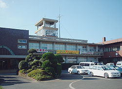
 Nakatane Town Hall | |
 Flag  Seal | |
 Location of Nakatane in Kagoshima Prefecture | |
 Nakatane | |
| Coordinates: 30°32′23″N 130°57′10″E | |
| Country | Japan |
| Region | Kyushu (Ōsumi Islands) |
| Prefecture | Kagoshima Prefecture |
| District | Kumage |
| Area | |
| • Total | 137.78 km2 (53.20 sq mi) |
| Population (June 1, 2013) | |
| • Total | 8,439 |
| • Density | 61.2/km2 (159/sq mi) |
| Time zone | UTC+9 (Japan Standard Time) |
| - Tree | Oak |
| - Flower | Hibiscus mutabilis; Alpinia zerumbet |
| - Insect | Hebomoia glaucippe |
| Phone number | 099-222-3141 |
| Address | 5186, Nonaka, Nakanotane-cho, Kumage-gun, Kagoshima-ken 891-3692 |
| Climate | Cfa |
| Website | town |
As of June 2013, the town has an estimated population of 8,439 and a population density of 61.2 persons per km². The total area is 137.78 km².
Geography
Nakatane occupies the center of the island of Tanegashima, with the East China Sea to the west and the Pacific Ocean to the east.
Surrounding municipalities
- Nishinoomote
- Minamitane
- Mishima
Climate
The climate is classified as humid subtropical (Köppen climate classification Cfa) with very warm summers and mild winters. Precipitation is high throughout the year, but is highest in the months of May, June and September.
| Climate data for Nakatane (2006−2020 normals, extremes 2006−present) | |||||||||||||
|---|---|---|---|---|---|---|---|---|---|---|---|---|---|
| Month | Jan | Feb | Mar | Apr | May | Jun | Jul | Aug | Sep | Oct | Nov | Dec | Year |
| Record high °C (°F) | 21.5 (70.7) |
23.1 (73.6) |
24.7 (76.5) |
26.9 (80.4) |
29.7 (85.5) |
31.1 (88.0) |
31.7 (89.1) |
33.2 (91.8) |
31.7 (89.1) |
29.8 (85.6) |
26.2 (79.2) |
25.2 (77.4) |
33.2 (91.8) |
| Average high °C (°F) | 12.6 (54.7) |
13.8 (56.8) |
16.3 (61.3) |
19.4 (66.9) |
22.7 (72.9) |
25.0 (77.0) |
28.7 (83.7) |
29.4 (84.9) |
27.2 (81.0) |
23.7 (74.7) |
19.4 (66.9) |
14.9 (58.8) |
21.1 (70.0) |
| Daily mean °C (°F) | 9.5 (49.1) |
10.5 (50.9) |
12.8 (55.0) |
15.9 (60.6) |
19.4 (66.9) |
22.4 (72.3) |
25.8 (78.4) |
26.5 (79.7) |
24.3 (75.7) |
20.7 (69.3) |
16.3 (61.3) |
11.7 (53.1) |
18.0 (64.4) |
| Average low °C (°F) | 6.1 (43.0) |
7.0 (44.6) |
9.1 (48.4) |
12.4 (54.3) |
16.2 (61.2) |
20.2 (68.4) |
23.7 (74.7) |
24.3 (75.7) |
22.0 (71.6) |
17.9 (64.2) |
12.7 (54.9) |
8.0 (46.4) |
15.0 (59.0) |
| Record low °C (°F) | −2.2 (28.0) |
−3.0 (26.6) |
−1.0 (30.2) |
3.4 (38.1) |
6.6 (43.9) |
15.3 (59.5) |
17.6 (63.7) |
19.6 (67.3) |
15.6 (60.1) |
8.7 (47.7) |
3.7 (38.7) |
−0.1 (31.8) |
−3.0 (26.6) |
| Average precipitation mm (inches) | 105.6 (4.16) |
155.1 (6.11) |
207.5 (8.17) |
229.6 (9.04) |
311.1 (12.25) |
632.2 (24.89) |
272.2 (10.72) |
188.9 (7.44) |
311.9 (12.28) |
243.3 (9.58) |
167.7 (6.60) |
140.0 (5.51) |
2,989.2 (117.69) |
| Average precipitation days (≥ 1.0 mm) | 10.2 | 12.0 | 12.9 | 11.9 | 12.0 | 18.7 | 10.6 | 12.5 | 14.3 | 10.7 | 10.4 | 10.5 | 146.7 |
| Source: Japan Meteorological Agency[1][2] | |||||||||||||
History
Nakatane Village was established on April 1, 1889. A power station was built in 1925, and the first telephone was installed in 1938. On November 10, 1940, Nakatane was upgraded to town status. Tanegashima Airport opened in Nakatane in 1958.
Nakatane is featured in the Japanese animated feature film, 5 Centimeters Per Second, directed by Makoto Shinkai. It was released on March 3, 2007 in Japan.
Transport
Highway
- Japan National Route 58
Airport
References
- 観測史上1~10位の値(年間を通じての値). JMA. Retrieved March 15, 2022.
- 気象庁 / 平年値(年・月ごとの値). JMA. Retrieved March 15, 2022.
External links
![]() Media related to Nakatane, Kagoshima at Wikimedia Commons
Media related to Nakatane, Kagoshima at Wikimedia Commons
- Nakatane official website (in Japanese)
На других языках
- [en] Nakatane, Kagoshima
[ru] Накатане
Накатане (яп. 中種子町 Накатанэ-тё:) — посёлок в Японии, находящийся в уезде Кумаге округа Кумаге префектуры Кагосима. Площадь посёлка составляет 137,78 км²[1], население — 8295 человек (1 августа 2014)[2], плотность населения — 60,20 чел./км².Другой контент может иметь иную лицензию. Перед использованием материалов сайта WikiSort.org внимательно изучите правила лицензирования конкретных элементов наполнения сайта.
WikiSort.org - проект по пересортировке и дополнению контента Википедии