world.wikisort.org - Japan
Satsumasendai (薩摩川内市, Satsumasendai-shi) is a city located in Kagoshima Prefecture, Japan.
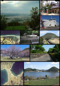
Satsumasendai
薩摩川内市 | |
|---|---|
City | |
 | |
|
Flag Emblem | |
Location of Satsumasendai in Kagoshima Prefecture | |
 Satsumasendai Location in Japan | |
| Coordinates: 31°49′N 130°18′E | |
| Country | Japan |
| Region | Kyushu |
| Prefecture | Kagoshima Prefecture |
| Government | |
| • Mayor | Hideo Iwakiri |
| Area | |
| • Total | 683.50 km2 (263.90 sq mi) |
| Population (May 1, 2017) | |
| • Total | 96,411 |
| • Density | 140/km2 (370/sq mi) |
| Time zone | UTC+09:00 (JST) |
| City hall address | 3-22, Kandachō, Satsumasendai-shi, Kagoshima-ken 895-8650 |
| Climate | Cfa |
| Website | www |
| Symbols | |
| Bird | Japanese white-eye |
| Fish | Stream: Ayu Oceanic: Slender sprat |
| Flower | Lilium speciosum |
| Tree | Round leaf holly (Ilex rotunda) |

The modern city of Satsumasendai was established on October 12, 2004, from the merger of the city of Sendai, the towns of Hiwaki, Iriki, Kedōin and Tōgō, and the Koshikijima Islands (which consisted of the villages of Kamikoshiki, Kashima, Sato and Shimokoshiki, all from Satsuma District).
As of May 2017, the city has an estimated population of 96,411 and a population density of 140 persons per km2.[1] The total area is 683.50 km2.
The city has regular Shinkansen services to Kagoshima City and Yatsushiro.
The city is also home to Kagoshima Immaculate Heart University, founded in 1994, which has a small population of foreign students.
A major employer is the Sendai nuclear power station.
Geography
Climate
Satsumasendai has a humid subtropical climate (Köppen climate classification Cfa) with hot summers and mild winters. Precipitation is significant throughout the year, and is heavier in summer, especially the months of June and July. The average annual temperature in Satsumasendai is 18.4 °C (65.1 °F). The average annual rainfall is 2,429.7 mm (95.66 in) with June as the wettest month. The temperatures are highest on average in August, at around 28.0 °C (82.4 °F), and lowest in January, at around 9.4 °C (48.9 °F).[2] Its record high is 37.5 °C (99.5 °F), reached on 19 August 2013, and its record low is −1.5 °C (29.3 °F), reached on 24 January 2016.[3]
| Climate data for Sendai, Satsumasendai (1991−2020 normals, extremes 1977−present) | |||||||||||||
|---|---|---|---|---|---|---|---|---|---|---|---|---|---|
| Month | Jan | Feb | Mar | Apr | May | Jun | Jul | Aug | Sep | Oct | Nov | Dec | Year |
| Record high °C (°F) | 22.1 (71.8) |
23.7 (74.7) |
25.8 (78.4) |
29.1 (84.4) |
31.9 (89.4) |
34.1 (93.4) |
36.1 (97.0) |
37.2 (99.0) |
35.4 (95.7) |
32.9 (91.2) |
27.4 (81.3) |
24.4 (75.9) |
37.2 (99.0) |
| Average high °C (°F) | 11.8 (53.2) |
13.3 (55.9) |
16.5 (61.7) |
21.0 (69.8) |
25.0 (77.0) |
27.3 (81.1) |
31.3 (88.3) |
32.5 (90.5) |
29.9 (85.8) |
25.3 (77.5) |
19.8 (67.6) |
14.2 (57.6) |
22.3 (72.2) |
| Daily mean °C (°F) | 6.6 (43.9) |
7.9 (46.2) |
11.0 (51.8) |
15.5 (59.9) |
19.6 (67.3) |
23.1 (73.6) |
27.0 (80.6) |
27.6 (81.7) |
24.7 (76.5) |
19.3 (66.7) |
13.8 (56.8) |
8.6 (47.5) |
17.1 (62.7) |
| Average low °C (°F) | 2.0 (35.6) |
2.8 (37.0) |
5.8 (42.4) |
10.2 (50.4) |
14.8 (58.6) |
19.6 (67.3) |
23.6 (74.5) |
24.0 (75.2) |
20.7 (69.3) |
14.6 (58.3) |
8.8 (47.8) |
3.8 (38.8) |
12.6 (54.6) |
| Record low °C (°F) | −6.6 (20.1) |
−7.5 (18.5) |
−4.0 (24.8) |
−1.7 (28.9) |
5.4 (41.7) |
10.6 (51.1) |
16.8 (62.2) |
17.1 (62.8) |
8.8 (47.8) |
2.7 (36.9) |
−1.3 (29.7) |
−4.9 (23.2) |
−7.5 (18.5) |
| Average precipitation mm (inches) | 85.0 (3.35) |
114.0 (4.49) |
156.5 (6.16) |
179.2 (7.06) |
208.6 (8.21) |
506.5 (19.94) |
334.0 (13.15) |
239.5 (9.43) |
231.4 (9.11) |
95.2 (3.75) |
110.7 (4.36) |
105.3 (4.15) |
2,368.8 (93.26) |
| Average precipitation days (≥ 1.0 mm) | 10.4 | 10.3 | 12.6 | 10.6 | 9.8 | 15.6 | 11.9 | 11.4 | 10.4 | 7.6 | 9.2 | 10.4 | 130.2 |
| Mean monthly sunshine hours | 111.3 | 125.8 | 159.1 | 177.5 | 177.8 | 107.5 | 173.2 | 202.9 | 172.8 | 182.0 | 147.6 | 120.8 | 1,858.2 |
| Source: Japan Meteorological Agency[4][5] | |||||||||||||
| Climate data for Naka-Koshiki-shima, Satsumasendai (1991−2020 normals, extremes 1977−present) | |||||||||||||
|---|---|---|---|---|---|---|---|---|---|---|---|---|---|
| Month | Jan | Feb | Mar | Apr | May | Jun | Jul | Aug | Sep | Oct | Nov | Dec | Year |
| Record high °C (°F) | 22.0 (71.6) |
22.3 (72.1) |
25.3 (77.5) |
28.5 (83.3) |
30.0 (86.0) |
32.1 (89.8) |
35.2 (95.4) |
37.5 (99.5) |
34.1 (93.4) |
31.7 (89.1) |
26.6 (79.9) |
24.5 (76.1) |
37.5 (99.5) |
| Average high °C (°F) | 12.2 (54.0) |
13.1 (55.6) |
15.9 (60.6) |
20.1 (68.2) |
23.9 (75.0) |
26.4 (79.5) |
30.4 (86.7) |
31.9 (89.4) |
29.1 (84.4) |
24.6 (76.3) |
19.5 (67.1) |
14.5 (58.1) |
21.8 (71.2) |
| Daily mean °C (°F) | 9.4 (48.9) |
10.0 (50.0) |
12.5 (54.5) |
16.2 (61.2) |
19.9 (67.8) |
23.1 (73.6) |
27.0 (80.6) |
28.0 (82.4) |
25.4 (77.7) |
21.0 (69.8) |
16.2 (61.2) |
11.5 (52.7) |
18.3 (65.0) |
| Average low °C (°F) | 6.4 (43.5) |
6.6 (43.9) |
8.9 (48.0) |
12.4 (54.3) |
16.1 (61.0) |
20.2 (68.4) |
24.4 (75.9) |
25.0 (77.0) |
22.3 (72.1) |
17.7 (63.9) |
12.8 (55.0) |
8.4 (47.1) |
15.1 (59.2) |
| Record low °C (°F) | −1.5 (29.3) |
−1.3 (29.7) |
−0.1 (31.8) |
3.4 (38.1) |
8.6 (47.5) |
12.4 (54.3) |
17.2 (63.0) |
19.5 (67.1) |
13.9 (57.0) |
8.4 (47.1) |
4.4 (39.9) |
−0.1 (31.8) |
−1.5 (29.3) |
| Average precipitation mm (inches) | 103.5 (4.07) |
116.0 (4.57) |
158.9 (6.26) |
208.7 (8.22) |
211.2 (8.31) |
475.5 (18.72) |
302.8 (11.92) |
215.6 (8.49) |
265.0 (10.43) |
110.9 (4.37) |
139.2 (5.48) |
122.4 (4.82) |
2,429.7 (95.66) |
| Average precipitation days (≥ 1.0 mm) | 12.0 | 10.8 | 12.6 | 10.5 | 10.2 | 14.5 | 10.2 | 9.9 | 10.0 | 7.2 | 9.5 | 11.0 | 128.4 |
| Mean monthly sunshine hours | 87.0 | 106.3 | 154.0 | 180.3 | 185.2 | 124.4 | 186.6 | 226.7 | 189.0 | 187.6 | 138.8 | 103.1 | 1,868.6 |
| Source: Japan Meteorological Agency[3][2] | |||||||||||||
Demographics
Per Japanese census data, the population of Satsumasendai in 2020 is 92,403 people.[6] Satsumasendai's population has been declining slowly since the census began in 1950, although there was a brief recovery in the 1980s.
| Year | Pop. | ±% |
|---|---|---|
| 1950 | 150,937 | — |
| 1955 | 146,197 | −3.1% |
| 1960 | 133,799 | −8.5% |
| 1965 | 119,063 | −11.0% |
| 1970 | 104,295 | −12.4% |
| 1975 | 99,151 | −4.9% |
| 1980 | 102,143 | +3.0% |
| 1985 | 108,105 | +5.8% |
| 1990 | 106,432 | −1.5% |
| 1995 | 106,737 | +0.3% |
| 2000 | 105,464 | −1.2% |
| 2005 | 102,370 | −2.9% |
| 2010 | 99,558 | −2.7% |
| 2015 | 96,076 | −3.5% |
| 2020 | 92,403 | −3.8% |
| Satsumasendai population statistics[6] | ||
Timeline
From 1889 to 2004
- April 1, 1889 - municipal status enforcement.
- Satsuma District : the villages of Kumanojō, Takae, Nagatoshi, Hirasa, Kami-Tōgō, Shimo-Tōgō, Hiwaki and Iriki.
- Taki District : the villages of Taki and Mizuhiki.
- Minami-Isa District : the villages of Ōmura, Kuroki and Imuta.
- Koshikijima District : the villages of Kami-Koshiki Shimo-Koshiki.
- March 29, 1896 - The districts of Taki, Minami-Isa and Koshikijima were merged into Satsuma District.
- May 20, 1929 - The villages of Kumanojō, Hirasa and Higashi-Mizuhiki were merged to become town of Sendai.
- July 1, 1933 - The village of Nishimizuhiki was renamed to Mizuhiki.
- February 11, 1940 - the town of Sendai was elevated city status to become the city of Sendai.
- November 10, 1940 - The village of Hiwaki was elevated to town status to become the town of Hiwaki.
- October 1, 1948 - The village of Iriki was elevated to town status to become the town of Iriki.
- April 1, 1951 - The village of Mizuhiki was merged into the city of Sendai.
- December 1, 1952 - The village of Kami-Tōgō was elevated to town status to become the town of Tōgō.
- April 1, 1955 - The villages of Ōmura, Kuroki and Imuta were merged to become the town of Kedōin.
- September 30, 1956 - The villages of Takae and Nagatoshi were merged into the city of Sendai.
- April 1, 1957
- Part of Shimo-Tōgō was merged into the town of Tōgō and the village of Taki (respectively).
- Remainder of Shimo-Tōgō was merged into the city of Sendai.
- January 1, 1960 - The village of Taki was elevated to town status to become the town of Taki.
- April 15, 1965 - The town of Taki was merged into city of Sendai.
Satsumasendai (After 2004)
- October 12, 2004 - the city of Satsumasendai was created from the merger of the city of Sendai, Kagoshima, the towns of Hiwaki, Iriki, Kedōin and Tōgō, and the Koshikijima Islands (which consisted of the villages of Kamikoshiki, Kashima, Sato and Shimokoshiki) (all from Satsuma District).
Festivals
- Sendai Otsunahiki
- Sendai River Fireworks Festival
Neighboring municipalities
Friendship cities
 Changshu, P.R. China[7]
- Malu Town, Jiading District, P.R. China
Transport
Railways
- Kyushu Railway Company
- Kyushu Shinkansen
- Kagoshima Main Line
- Sendai Station - Kumanojo Station - Kobanchaya Station
- Hisatsu Orange Railway
- Hisatsu Orange Railway Line
- Nishikata Station - Satsuma-Taki Station - Kusamichi Station - Kamisendai Station - Sendai Station
- Hisatsu Orange Railway Line
- Former railway line
- Japan National Railway
- Miyanojo Line(1924-1987)
- Sendai Station - Satsuma-Shirahama Station - Kusumoto Station - Yoshinoyama Station - Hiwaki Station - Kamihiwaki Station - Iriki Station
- Miyanojo Line(1924-1987)
Roads
- Highways
- Minamikyushu Expressway
- Satsumasendai-Miyako IC
- National Highway
- Route 3
- Route 267
- Route 328
- Route 504
References
- "Official website of Satsumasendai City" (in Japanese). Japan: Satsumasendai City. Retrieved 7 May 2017.
- 気象庁 / 平年値(年・月ごとの値). JMA. Retrieved March 26, 2022.
- 観測史上1~10位の値(年間を通じての値). JMA. Retrieved March 26, 2022.
- 観測史上1~10位の値(年間を通じての値). JMA. Retrieved March 27, 2022.
- 気象庁 / 平年値(年・月ごとの値). JMA. Retrieved March 27, 2022.
- Satsumasendai population statistics
- 友好都市 - Satsumasendai City
External links
- Satsumasendai City official website (in Japanese)
- Kagoshima Prefectural Visitors Bureau official website (in English)
- Sendai Giant Tug-of-war The Asahi Shimbun, 2012/09/23
Kagoshima (capital) | |||||||||||
| Core city | |||||||||||
| Cities |
| ||||||||||
| Districts |
| ||||||||||
List of mergers in Kagoshima Prefecture | |||||||||||
Authority control | |
|---|---|
| General | |
| National libraries | |
| Other |
|
На других языках
[de] Satsumasendai
Satsumasendai (japanisch 薩摩川内市, -shi) ist eine Stadt in der Präfektur Kagoshima in Japan.- [en] Satsumasendai, Kagoshima
[ru] Сацумасендай
Сацумасендай (яп. 薩摩川内市 Сацумасэндай-си) — город в Японии, находящийся в префектуре Кагосима. Площадь города составляет 683,50 км²[1], население — 96 762 человека (1 августа 2014)[2], плотность населения — 141,57 чел./км².Другой контент может иметь иную лицензию. Перед использованием материалов сайта WikiSort.org внимательно изучите правила лицензирования конкретных элементов наполнения сайта.
WikiSort.org - проект по пересортировке и дополнению контента Википедии