world.wikisort.org - Japan
Shimonoseki (Japanese: 下関市, Hepburn: Shimonoseki-shi) is a city located in Yamaguchi Prefecture, Japan. With a population of 265,684, it is the largest city in Yamaguchi Prefecture and the fifth-largest city in the Chūgoku region. It is located at the southwestern tip of Honshu facing the Tsushima Strait at the entrance to the Kanmon Straits (also known as the Straits of Shimonoseki) across from the city of Kitakyushu and the island of Kyushu. It is nicknamed the "Fugu Capital" for the locally caught pufferfish, and is the largest harvester of the pufferfish in Japan.[citation needed]
This article contains embedded lists that may be poorly defined, unverified or indiscriminate. (February 2021) |
Shimonoseki
下関市 | |
|---|---|
Core city | |
Central Shimonoseki and Kanmon Strait | |
|
Flag Seal | |
 Location of Shimonoseki in Yamaguchi Prefecture | |
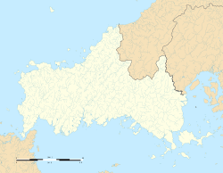 Shimonoseki Location in Japan  Shimonoseki Shimonoseki (Japan) | |
| Coordinates: 33°57′N 130°56′E | |
| Country | Japan |
| Region | Chūgoku (San'yō) |
| Prefecture | Yamaguchi Prefecture |
| First official recorded | 192 AD |
| As city settled for Akamazeki | April 1, 1889 |
| Current city's name changed | June 1, 1902 |
| Government | |
| • Mayor | Shintaro Maeda (since 2017) |
| Area | |
| • Total | 716.14 km2 (276.50 sq mi) |
| Population (October 1, 2016) | |
| • Total | 265,684 |
| • Density | 370/km2 (960/sq mi) |
| Time zone | UTC+09:00 (JST) |
| City hall address | 1-1 Nanbu, Shimonoseki-shi, Yamaguchi-ken 750-8521 |
| Climate | Cfa |
| Website | www |
| Symbols | |
| Flower | Crinum asiaticum |
| Tree | Camphor Laurel |
History
The geographical position of Shimonoseki has given it historical importance. The Heike and Genji fought at Dan-no-ura near the present Kanmon Bridge. In February 1691, German explorer Engelbert Kaempfer visited the town as part of his two-year stay in Japan, and described it as having around 400 to 500 houses, and as a major port in the region for supplying ship provisions.[1] The Bombardment of Shimonoseki occurred in 1864, and the Treaty of Shimonoseki was signed there in 1895, seeing a defeated China hand over Taiwan, Penghu, and Port Arthur to the victorious Japanese.
An Imperial decree in July 1899 established Shimonoseki as an open port for trading with the United States and the United Kingdom.[2]


On February 13, 2005, Shimonoseki absorbed the towns of Hōhoku, Kikugawa, Toyota and Toyoura (all from Toyoura District) to create the new and expanded city of Shimonseki. Since October 1, 2005, the city has been designated as a core city by the Japanese Government.[citation needed]
Climate
Shimonoseki has a humid subtropical climate (Köppen climate classification Cfa) with hot summers and cool winters. Precipitation is significant throughout the year, but is heavier in summer.
| Climate data for Shimonoseki (1991−2020 normals, extremes 1883−present) | |||||||||||||
|---|---|---|---|---|---|---|---|---|---|---|---|---|---|
| Month | Jan | Feb | Mar | Apr | May | Jun | Jul | Aug | Sep | Oct | Nov | Dec | Year |
| Record high °C (°F) | 19.1 (66.4) |
23.7 (74.7) |
26.2 (79.2) |
29.7 (85.5) |
30.9 (87.6) |
33.7 (92.7) |
36.2 (97.2) |
37.0 (98.6) |
35.0 (95.0) |
30.6 (87.1) |
26.9 (80.4) |
26.2 (79.2) |
37.0 (98.6) |
| Average high °C (°F) | 9.7 (49.5) |
10.5 (50.9) |
13.7 (56.7) |
18.4 (65.1) |
22.7 (72.9) |
25.8 (78.4) |
29.7 (85.5) |
31.3 (88.3) |
27.8 (82.0) |
23.0 (73.4) |
17.5 (63.5) |
12.3 (54.1) |
20.2 (68.4) |
| Daily mean °C (°F) | 7.2 (45.0) |
7.5 (45.5) |
10.3 (50.5) |
14.7 (58.5) |
19.1 (66.4) |
22.5 (72.5) |
26.5 (79.7) |
27.9 (82.2) |
24.6 (76.3) |
19.7 (67.5) |
14.5 (58.1) |
9.5 (49.1) |
17.0 (62.6) |
| Average low °C (°F) | 4.8 (40.6) |
4.9 (40.8) |
7.4 (45.3) |
11.6 (52.9) |
16.2 (61.2) |
20.1 (68.2) |
24.2 (75.6) |
25.6 (78.1) |
22.2 (72.0) |
16.9 (62.4) |
11.8 (53.2) |
7.0 (44.6) |
14.4 (57.9) |
| Record low °C (°F) | −6.3 (20.7) |
−6.5 (20.3) |
−5.5 (22.1) |
0.5 (32.9) |
6.5 (43.7) |
9.5 (49.1) |
15.1 (59.2) |
17.5 (63.5) |
12.8 (55.0) |
5.9 (42.6) |
0.7 (33.3) |
−4.6 (23.7) |
−6.5 (20.3) |
| Average precipitation mm (inches) | 80.0 (3.15) |
75.9 (2.99) |
121.2 (4.77) |
130.8 (5.15) |
154.2 (6.07) |
253.6 (9.98) |
309.4 (12.18) |
190.0 (7.48) |
162.6 (6.40) |
83.7 (3.30) |
81.9 (3.22) |
69.1 (2.72) |
1,712.3 (67.41) |
| Average snowfall cm (inches) | 1 (0.4) |
1 (0.4) |
0 (0) |
0 (0) |
0 (0) |
0 (0) |
0 (0) |
0 (0) |
0 (0) |
0 (0) |
0 (0) |
0 (0) |
2 (0.8) |
| Average precipitation days (≥ 1.0 mm) | 9.3 | 9.1 | 10.1 | 9.6 | 8.7 | 11.3 | 10.7 | 9.1 | 8.5 | 6.1 | 8.0 | 9.0 | 109.5 |
| Average snowy days (≥ 1 cm) | 0.4 | 0.6 | 0 | 0 | 0 | 0 | 0 | 0 | 0 | 0 | 0 | 0 | 1 |
| Average relative humidity (%) | 63 | 63 | 65 | 67 | 70 | 78 | 79 | 75 | 73 | 67 | 66 | 63 | 69 |
| Mean monthly sunshine hours | 95.8 | 116.1 | 162.9 | 187.6 | 207.1 | 146.6 | 172.4 | 207.2 | 161.9 | 176.3 | 134.7 | 102.6 | 1,875.9 |
| Source: Japan Meteorological Agency[3][4] | |||||||||||||
| Climate data for Toyota, Shimonoseki (1991−2020 normals, extremes 1977−present) | |||||||||||||
|---|---|---|---|---|---|---|---|---|---|---|---|---|---|
| Month | Jan | Feb | Mar | Apr | May | Jun | Jul | Aug | Sep | Oct | Nov | Dec | Year |
| Record high °C (°F) | 16.7 (62.1) |
21.8 (71.2) |
25.1 (77.2) |
28.4 (83.1) |
31.4 (88.5) |
32.2 (90.0) |
35.7 (96.3) |
36.2 (97.2) |
33.9 (93.0) |
30.7 (87.3) |
26.0 (78.8) |
23.2 (73.8) |
36.2 (97.2) |
| Average high °C (°F) | 8.7 (47.7) |
9.8 (49.6) |
13.4 (56.1) |
18.6 (65.5) |
23.1 (73.6) |
25.9 (78.6) |
29.3 (84.7) |
30.7 (87.3) |
27.2 (81.0) |
22.3 (72.1) |
16.7 (62.1) |
11.2 (52.2) |
19.7 (67.5) |
| Daily mean °C (°F) | 3.6 (38.5) |
4.4 (39.9) |
7.5 (45.5) |
12.4 (54.3) |
17.3 (63.1) |
21.2 (70.2) |
25.1 (77.2) |
25.9 (78.6) |
22.0 (71.6) |
16.1 (61.0) |
10.4 (50.7) |
5.4 (41.7) |
14.3 (57.7) |
| Average low °C (°F) | −1.1 (30.0) |
−0.8 (30.6) |
1.7 (35.1) |
6.1 (43.0) |
11.4 (52.5) |
17.0 (62.6) |
21.6 (70.9) |
22.1 (71.8) |
17.8 (64.0) |
10.8 (51.4) |
5.0 (41.0) |
0.5 (32.9) |
9.3 (48.8) |
| Record low °C (°F) | −7.9 (17.8) |
−9.1 (15.6) |
−6.2 (20.8) |
−4.0 (24.8) |
0.0 (32.0) |
5.5 (41.9) |
12.0 (53.6) |
14.3 (57.7) |
4.6 (40.3) |
−0.6 (30.9) |
−3.7 (25.3) |
−6.3 (20.7) |
−9.1 (15.6) |
| Average precipitation mm (inches) | 90.8 (3.57) |
88.3 (3.48) |
140.5 (5.53) |
151.4 (5.96) |
183.7 (7.23) |
272.5 (10.73) |
342.8 (13.50) |
201.2 (7.92) |
167.8 (6.61) |
93.3 (3.67) |
88.2 (3.47) |
83.1 (3.27) |
1,899.1 (74.77) |
| Average precipitation days (≥ 1.0 mm) | 11.3 | 10.7 | 11.6 | 10.0 | 9.5 | 12.4 | 11.6 | 9.9 | 9.5 | 7.7 | 9.3 | 11.1 | 124.6 |
| Mean monthly sunshine hours | 99.8 | 107.6 | 156.1 | 182.9 | 206.1 | 137.0 | 152.6 | 189.8 | 151.6 | 169.5 | 134.5 | 103.9 | 1,791.3 |
| Source: Japan Meteorological Agency[5][6] | |||||||||||||
Demographics
Per Japanese census data, the population of Shimonoseki in 2020 is 255,051 people.[7] Shimonoseki has been conducting censuses since 1920.
|
|
| ||||||||||||||||||||||||||||||||||||||||||||||||||||||||||||||||||||||||
| Shimonoseki population statistics[7] | ||||||||||||||||||||||||||||||||||||||||||||||||||||||||||||||||||||||||||
Transportation
This section needs additional citations for verification. (February 2021) |
Ferries from Shimonoseki Port International Terminal
- The Kanpu ferry to Busan, South Korea regularly.
- The Gwangyang Beech to Gwangyang, South Korea regularly.
- The Orient ferry to Shanghai, China regularly.
- The Orient ferry to Qingdao, China was suspended in November 2015.[8]
Trains
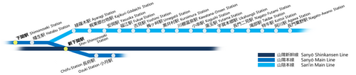
- The main Shinkansen station
- Sanyō Shinkansen
- The main JR West stations
- San'yō Main Line
- Shimonoseki Station
- Hatabu Station - Hatabu Station is a railway station on the San'yō Main Line and the San'in Main Line.
- Shin-Shimonoseki Station - Shin-Shimonoseki Station is a railway station on the Sanyō Shinkansen Line and the San'yō Main Line.
- Chōfu Station
- Ozuki Station
- San'in Main Line
- San'yō Main Line
Buses
Regular bus services are provided by Sanden Kohtsu, as well as by group companies of Sanden Kohtsu.
- Bus companies (A loop-line bus in the city.)
- Sanden Kohtsu Co., Ltd.
- Blue Line Kohtsu Co., Ltd.
- Intercity bus services (arrival and departure in Shimonoseki city) go to the following destinations: Tokyo, Osaka, Kobe, Hiroshima, Fukuoka, Fukuoka Airport, etc.
Roads
Expressway
- Chūgoku Expressway
- Shimonoseki interchange
- Ozuki interchange
Bypasses
- Ozuki Bypass
- Shimonoseki-Kita Bypass
National Highways
- National Route 2
- National Route 9
- National Route 191
- National Route 435
- National Route 491
Airports
Shimonoseki is served by four airports outside the city.
- Kitakyūshū Airport
- Saga Airport
- Yamaguchi Ube Airport (only for domestic flights)
- Fukuoka Airport
Education
Universities and colleges

- National Fisheries University (水産大学校, Suisan daigakkō) (Yoshimi)
- Shimonoseki City University (Daigaku-cho)
- University of East Asia (Shin-Shimonoseki Station)
- Baiko Gakuin University (Higashieki)
- Baiko Gakuin University Women's Junior College (Shimonoseki)
- Shimonoseki Junior College (Sakurayama-cho)
Primary and secondary schools
This section needs expansion. You can help by adding to it. (October 2015) |
The city has a North Korean school, Yamaguchi Korean Elementary and Junior High School (山口朝鮮初中級学校).[9] It formerly housed two other North Korean schools, Yamaguchi Korean High School and Shimonoseki Korean Elementary and Junior High School (下関朝鮮初中級学校).[10]
As a city of a quarter million people, it has some public schools too.[11][12]
Culture
Festivals
Shimonoseki is home to many festivals that are held throughout the year. Of these, the most famous are the Shimonoseki Kaikyo Festival and Shimonoseki Bakan Festival.
- Shimonoseki Fugu (Blowfish) Festival (February) : Haedomari Market
- Kawatana Onsen(hot spring) Festival (April)
- Shimonoseki Kaikyo Festival (May) : Karato, Ganryujima Island
- Suhouteisai Festival (August) : Castle town Chofu
- Kanmon Kaikyo Fireworks Festival (August) : Karato(Aruka Port area)
- Shimonoseki Bakan Festival (August) : Along the street from Karato-cho to Shimonoseki Station
- TOUR de Shimonoseki (October/November)
- Shimonoseki Kaikyo Marathon (November)
- Shimonoseki Fish Festival (November) : Shimonoseki Fishing Port
- Little Busan Fest (November) : Green Mall
Architecture
- Kōzan-ji - The butsuden completed in 1320 is a National Treasure of Japan.
- Akama Shrine
- Kaikyō Yume Tower
Museums
- Shimonoseki City Art Museum
- Shimonoseki Chofu Museum
- Shimonoseki City Archaeological Museum
- Shimonoseki Marine Science Museum (Shimonoseki City Aquarium) (Kaikyo Kan)
- Doigahama Site Anthropological Museum
- The firefly museum of toyota town
- The Yamagin Archive (やまぎん史料館) of the Yamaguchi Bank
Monuments
- The Mimosusogawa Park (みもすそ川公園) in Shimonoseki commemorates the final stage of the Genpei war between the feudal Taira clan and Minamoto clan (1180–1185). There is a historical monument with cannons.
Sports
Professional Teams
- FC Baleine Shimonoseki (Football)
Sporting venues
- Shimonoseki Baseball Stadium
- Shimonoseki Boat Race Stadium (Shimonoseki Kyōtei)
- Shimonoseki City Gymnasium
- Shimonoseki Track and field stadium
- Shimonoseki city swimming pool
- Nogihama General Park (Football stadium)
Crime and safety
The Goda-ikka yakuza syndicate is headquartered in Shimonoseki. A designated yakuza group, the Goda-ikka is the largest yakuza syndicate in Yamaguchi Prefecture.[13]
Twin towns – sister cities
Shimonoseki is twinned with:[14]
Notable people
- Kinuyo Tanaka
- Yūsaku Matsuda
- Atsushi Tamura (Comedian, actor and singer)
References
- Kaempfer, Engelbert (1729). Histoire naturelle, civile et ecclésiastique de l'Empire du Japon. Tome 2 (translated by François Naudé) (in French). The Hague. p. 176.
- US Department of State. (1906). A digest of international law as embodied in diplomatic discussions, treaties and other international agreements (John Bassett Moore, ed.), Vol. 5, p. 759.
- 観測史上1~10位の値(年間を通じての値). JMA. Retrieved March 2, 2022.
- 気象庁 / 平年値(年・月ごとの値). JMA. Retrieved March 2, 2022.
- 気象庁 / 平年値(年・月ごとの値). JMA. Retrieved May 25, 2022.
- 観測史上1~10位の値(年間を通じての値). JMA. Retrieved May 25, 2022.
- Shimonoseki population statistics
- オリエントフェリー運航一時休止について(お知らせ) (PDF). Archived from the original on 2016-02-07.
{{cite web}}: CS1 maint: bot: original URL status unknown (link) - ウリハッキョ一覧. Chongryon. Archived from the original on December 19, 2015. Retrieved October 14, 2015.().
- ウリハッキョ一覧. Chongryon. November 6, 2005. Archived from the original on November 6, 2005. Retrieved October 15, 2015.
- 下関市内小中学校 - 山口県下関市(教育委員会) (in Japanese). City of Shimonoseki Education Committee. Retrieved 2020-01-08.
- http://www.shimosho.ed.jp/wordpress/ Shimonoseki Commercial High School
- "The 7th President announces the succession, The Goda-ikka, The Prefectural Police on red alert", 21 October 2009, Yamaguchi Shimbun (in Japanese)
- "姉妹友好都市". city.shimonoseki.lg.jp (in Japanese). Shimonoseki. Retrieved 2020-04-08.
External links
- Shimonoseki City official website (in Japanese)
- Shimonoseki City official website in other languages
 Shimonoseki travel guide from Wikivoyage
 Geographic data related to Shimonoseki at OpenStreetMap
- . The American Cyclopædia. 1879.
- Shimonoseki City Tourism Promotion Film Shimonoseki City Official Channel
Yamaguchi (capital) | ||
| Core city | ||
| Cities | ||
| Districts |
| |
List of mergers in Yamaguchi Prefecture | ||
| 2,000,000 and more | |
|---|---|
| 1,000,000–1,999,999 | |
| 500,000–999,999 | |
| 200,000–499,999 |
|
Authority control | |
|---|---|
| General | |
| National libraries | |
| Scientific databases | |
| Other |
|
На других языках
[de] Shimonoseki
Shimonoseki (japanisch 下関市 -shi, veraltet auch: Schimonoseki) ist die südwestlichste Stadt auf Honshū, der Hauptinsel von Japan, und gehört zur Präfektur Yamaguchi.- [en] Shimonoseki
[es] Shimonoseki
La ciudad de Shimonoseki (下関市, Shimonoseki-shi?) de Japón, situada en el extremo suroeste de la isla de Honshū, en la prefectura de Yamaguchi. Se ubica frente a la ciudad de Kitakyūshū, en la isla de Kyūshū, y ambas se comunican por túneles de ferrocarril y de carretera. Shimonoseki es uno de los principales puertos pesqueros del país y un importante núcleo industrial con astilleros, fábricas de productos químicos, textiles, de conservas e ingeniería. La principal atracción turística es el santuario shinto dedicado al Emperador Antoku. En Shimonoseki, antes denominada Akamagaseki y que popularmente se conocía como Bakan, se firmó el tratado que puso fin a la Primera Guerra Sino-japonesa de 1894-1895 (ver Tratado de Shimonoseki).[ru] Симоносеки
Симоносе́ки (яп. 下関市 Симоносэки-си) — центральный город Японии на юго-западной оконечности острова Хонсю, самый крупный город префектуры Ямагути. Площадь города составляет 716,17 км²[1], население — 271 072 человека (1 августа 2014)[2], плотность населения — 378,50 чел./км².Другой контент может иметь иную лицензию. Перед использованием материалов сайта WikiSort.org внимательно изучите правила лицензирования конкретных элементов наполнения сайта.
WikiSort.org - проект по пересортировке и дополнению контента Википедии