world.wikisort.org - Japan
Nagato (長門市, Nagato-shi) is a city in Yamaguchi Prefecture, Japan. The city was founded on March 31, 1954. As of October 1, 2016, the city has an estimated population of 34,882 and a population density of 97 persons per km². The total area is 357.92 km².
Nagato
長門市 | |
|---|---|
City | |
 Nagato city hall | |
 Flag  Seal | |
 Location of Nagato in Yamaguchi Prefecture | |
 Nagato Location in Japan | |
| Coordinates: 34°22′20″N 131°11′00″E | |
| Country | Japan |
| Region | Chūgoku (San'yō) |
| Prefecture | Yamaguchi Prefecture |
| Government | |
| • Mayor | Kurao Ōnishi |
| Area | |
| • Total | 357.92 km2 (138.19 sq mi) |
| Population (October 1, 2016) | |
| • Total | 34,882 |
| • Density | 97/km2 (250/sq mi) |
| Time zone | UTC+09:00 (JST) |
| Climate | Cfa |
| Website | www |
| Symbols | |
| Flower | Sakura and Azalea |
| Tree | Sakura and Azalea |
Nagato consists of five smaller towns that were absorbed over the past several years. The towns are Fukawa, Senzaki, Yuya, Heki and Misumi (all from Ōtsu District). Nagato also encompasses Omijima Island and the township of Kayoi.
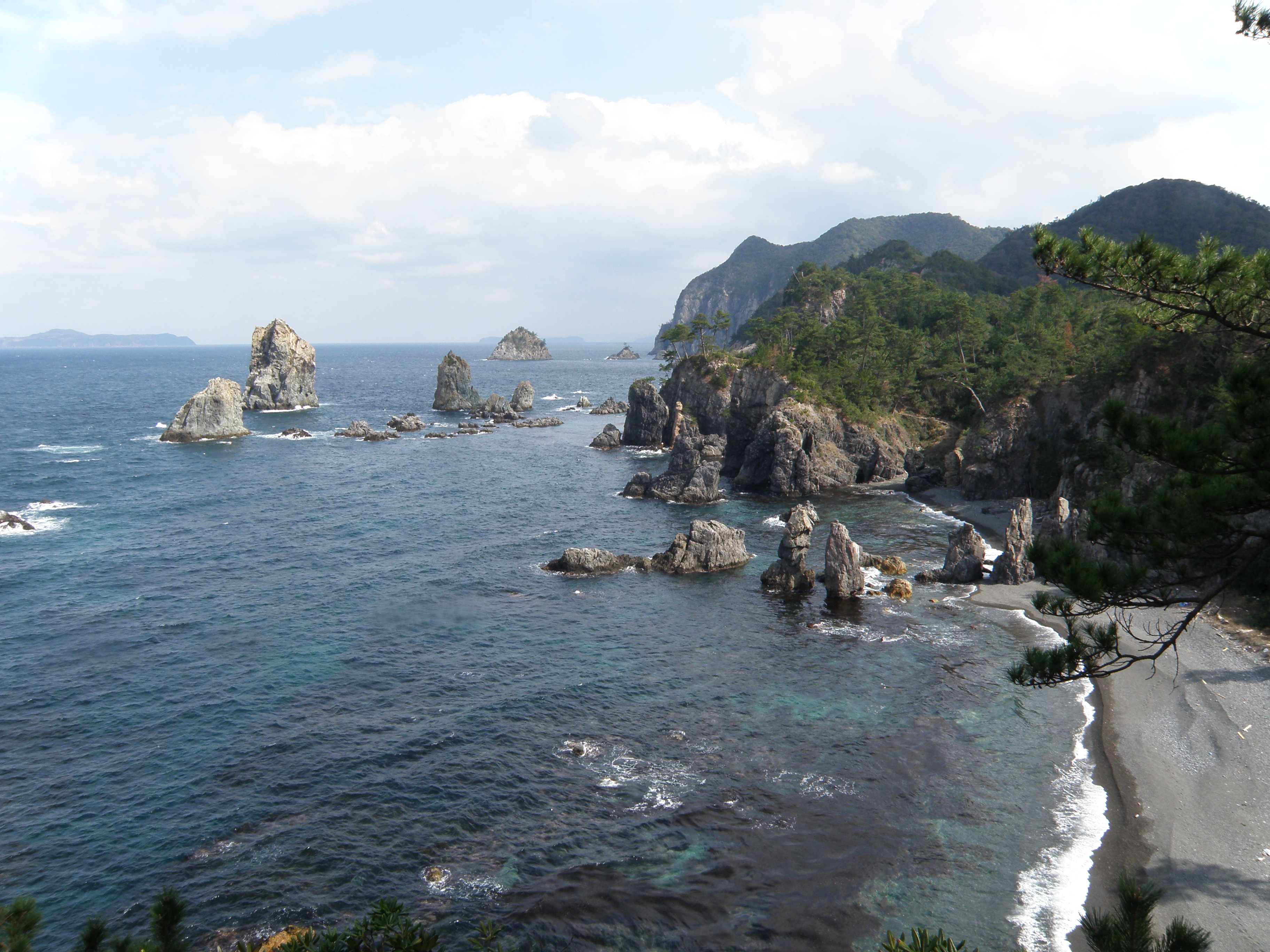
The nearby Omijima Island has many pebbled beaches and scuba diving on one of its northern beaches. The island is reached by a large road bridge which connects the Senzaki Peninsula with the southern edge of the island.
There are many onsen on the southern edge of the town in Yumoto with hot springs.
History
In the Tokugawa era, the area was under the jurisdiction of the Chōshū domain.
In the 2017 Japanese general election, 76.25% of Nagato's proportional ballots were cast for either one of the two parties in the conservative ruling coalition (the Liberal Democratic Party and Komeito) or one of the two minor LDP-allied conservative parties (Party for Japanese Kokor) and New Party Daichi), making it the most conservative city in the country for that election under this definition, and the second most conservative municipality overall behind Himeshima, Ōita.[1]
Geography
Climate
Nagato has a humid subtropical climate (Köppen climate classification Cfa) with hot summers and cool winters. Precipitation is significant throughout the year, but is much higher in summer than in winter. The average annual temperature in Nagato is 15.9 °C (60.6 °F). The average annual rainfall is 1,790.8 mm (70.50 in) with July as the wettest month. The temperatures are highest on average in August, at around 27.1 °C (80.8 °F), and lowest in January, at around 5.8 °C (42.4 °F).[2] The highest temperature ever recorded in Nagato was 36.7 °C (98.1 °F) on 14 August 2018; the coldest temperature ever recorded was −6.1 °C (21.0 °F) on 26 February 1981.[3]
| Climate data for Yuya, Nagato (1991−2020 normals, extremes 1977−present) | |||||||||||||
|---|---|---|---|---|---|---|---|---|---|---|---|---|---|
| Month | Jan | Feb | Mar | Apr | May | Jun | Jul | Aug | Sep | Oct | Nov | Dec | Year |
| Record high °C (°F) | 18.6 (65.5) |
23.2 (73.8) |
25.5 (77.9) |
29.5 (85.1) |
30.7 (87.3) |
33.4 (92.1) |
35.7 (96.3) |
36.7 (98.1) |
35.2 (95.4) |
31.9 (89.4) |
27.0 (80.6) |
23.9 (75.0) |
36.7 (98.1) |
| Average high °C (°F) | 9.5 (49.1) |
10.5 (50.9) |
13.8 (56.8) |
18.7 (65.7) |
23.2 (73.8) |
26.0 (78.8) |
29.9 (85.8) |
31.3 (88.3) |
27.4 (81.3) |
22.6 (72.7) |
17.4 (63.3) |
12.0 (53.6) |
20.2 (68.3) |
| Daily mean °C (°F) | 5.8 (42.4) |
6.4 (43.5) |
9.3 (48.7) |
13.9 (57.0) |
18.4 (65.1) |
21.9 (71.4) |
26.1 (79.0) |
27.1 (80.8) |
23.1 (73.6) |
17.8 (64.0) |
12.8 (55.0) |
8.0 (46.4) |
15.9 (60.6) |
| Average low °C (°F) | 1.8 (35.2) |
2.0 (35.6) |
4.4 (39.9) |
8.7 (47.7) |
13.6 (56.5) |
18.3 (64.9) |
22.9 (73.2) |
23.7 (74.7) |
19.5 (67.1) |
13.2 (55.8) |
8.1 (46.6) |
3.8 (38.8) |
11.7 (53.0) |
| Record low °C (°F) | −5.2 (22.6) |
−6.1 (21.0) |
−3.6 (25.5) |
−1.1 (30.0) |
3.1 (37.6) |
7.9 (46.2) |
13.7 (56.7) |
15.9 (60.6) |
7.0 (44.6) |
2.8 (37.0) |
−0.4 (31.3) |
−3.5 (25.7) |
−6.1 (21.0) |
| Average precipitation mm (inches) | 97.8 (3.85) |
86.8 (3.42) |
137.7 (5.42) |
130.4 (5.13) |
146.2 (5.76) |
222.5 (8.76) |
279.7 (11.01) |
198.3 (7.81) |
202.0 (7.95) |
106.5 (4.19) |
99.4 (3.91) |
83.5 (3.29) |
1,790.8 (70.50) |
| Average precipitation days (≥ 1.0 mm) | 11.3 | 10.6 | 11.4 | 10.2 | 9.2 | 11.5 | 11.4 | 9.0 | 10.7 | 8.0 | 10.0 | 10.4 | 123.7 |
| Mean monthly sunshine hours | 83.5 | 101.0 | 151.2 | 182.0 | 204.1 | 137.3 | 164.1 | 197.4 | 143.5 | 156.9 | 116.6 | 86.3 | 1,723.8 |
| Source: Japan Meteorological Agency[2][3] | |||||||||||||
Demographics
Per Japanese census data, the population of Nagato in 2020 is 32,519 people.[4] Nagato has been conducting censuses since 1920.
|
|
| ||||||||||||||||||||||||||||||||||||||||||||||||||||||||||||||||||||||||
| Nagato population statistics[4] | ||||||||||||||||||||||||||||||||||||||||||||||||||||||||||||||||||||||||||
Transportation
Railways
- West Japan Railway Company(JR Nishi Nihon)
- San'in Main Line
- Senzaki Branch Line (San'in Main Line)
- Mine Line
Famous people
- Shinzo Abe
- Misuzu Kaneko
- Shigeru Aburaya
Economy
Fujimitsu Corporation, a manufacturer of fish surimi products, is headquartered in the city.[5]
Recent annexion
- On March 22, 2005, the towns of Heki, Misumi and Yuya (all from Ōtsu District) were merged into Nagato.
References
- "平成29年10月22日執行 衆議院議員総選挙 市区町村別得票数". Ministry of Internal Affairs and Communications.
{{cite web}}: CS1 maint: url-status (link) - 気象庁 / 平年値(年・月ごとの値). JMA. Retrieved May 27, 2022.
- 観測史上1~10位の値(年間を通じての値). JMA. Retrieved May 27, 2022.
- Nagato population statistics
- "Corporate Information". Fujimitsu Corporation. Retrieved December 6, 2018.
External links
![]() Media related to Nagato, Yamaguchi at Wikimedia Commons
Media related to Nagato, Yamaguchi at Wikimedia Commons
- Nagato City official website (in Japanese)
Yamaguchi (capital) | ||
| Core city | ||
| Cities | ||
| Districts |
| |
List of mergers in Yamaguchi Prefecture | ||
Authority control | |
|---|---|
| General | |
| National libraries | |
| Scientific databases | |
| Other |
|
This article about a location in Yamaguchi Prefecture is a stub. You can help Wikipedia by expanding it. |
На других языках
[de] Nagato
Nagato (japanisch .mw-parser-output .Hani{font-size:110%}長門市, Nagato-shi) ist eine Stadt in der Präfektur Yamaguchi in Japan.- [en] Nagato, Yamaguchi
[es] Nagato (Yamaguchi)
Nagato (長門市, Nagato-shi?) es una ciudad japonesa ubicada en la prefectura de Yamaguchi en Japón, fundada el 31 de marzo de 1954.[ru] Нагато (город)
Нагато (яп. 長門市 Нагато-си) — город в Японии, находящийся в префектуре Ямагути. Площадь города составляет 357,94 км²[1], население — 35 771 человек (1 августа 2014)[2], плотность населения — 99,94 чел./км².Другой контент может иметь иную лицензию. Перед использованием материалов сайта WikiSort.org внимательно изучите правила лицензирования конкретных элементов наполнения сайта.
WikiSort.org - проект по пересортировке и дополнению контента Википедии