world.wikisort.org - Japan
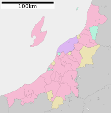
Niigata Prefecture (新潟県, Niigata-ken) is a prefecture in the Chūbu region of Honshu of Japan.[1] Niigata Prefecture has a population of 2,227,496 (1 July 2019) and is the fifth-largest prefecture of Japan by geographic area at 12,584.18 km2 (4,858.78 sq mi). Niigata Prefecture borders Toyama Prefecture and Nagano Prefecture to the southwest, Gunma Prefecture to the south, Fukushima Prefecture to the east, and Yamagata Prefecture to the northeast.
This article may be expanded with text translated from the corresponding article in Japanese. (December 2016) Click [show] for important translation instructions.
|
This article needs additional citations for verification. (May 2022) |
Niigata Prefecture
新潟県 | |||||||
|---|---|---|---|---|---|---|---|
Prefecture | |||||||
| Japanese transcription(s) | |||||||
| • Japanese | 新潟県 | ||||||
| • Rōmaji | Niigata-ken | ||||||
| |||||||
 Flag  Symbol | |||||||
 | |||||||
| Country | |||||||
| Region | Chūbu (Kōshinetsu) (Hokuriku) | ||||||
| Island | Honshu | ||||||
| Capital | Niigata | ||||||
| Subdivisions | Districts: 9, Municipalities: 30 | ||||||
| Government | |||||||
| • Governor | Hideyo Hanazumi | ||||||
| Area | |||||||
| • Total | 12,584.18 km2 (4,858.78 sq mi) | ||||||
| • Rank | 5th | ||||||
| Population (July 1, 2019) | |||||||
| • Total | 2,227,496 | ||||||
| • Rank | 14th | ||||||
| • Density | 180/km2 (460/sq mi) | ||||||
| ISO 3166 code | JP-15 | ||||||
| Website | www | ||||||
| Symbols | |||||||
| Bird | Crested ibis (Nipponia nippon) | ||||||
| Flower | Tulip (Tulipa gesneriana) | ||||||
| Tree | Camellia (Camellia japonica) | ||||||


Niigata is the capital and largest city of Niigata Prefecture, with other major cities including Nagaoka, Jōetsu, and Sanjō.[2] Niigata Prefecture contains the Niigata Major Metropolitan Area centered on Niigata with a population of 1,395,612, the largest metropolitan area on the Sea of Japan coast and the twelfth-largest in Japan. Niigata Prefecture is part of the historic Hokuriku region and features Sado Island, the sixth largest island of Japan in area following the four main islands and Okinawa Island.
History
Until after the Meiji Restoration, the area that is now Niigata Prefecture was divided into Echigo Province (on the mainland) and Sado Province.[3] During the Sengoku period, the Nagao clan, who were at times vassals to the Uesugi, ruled a fief in the western part of modern Niigata from Kasugayama Castle. The most notable member of the Nagao clan was Nagao Kagetora, later and better known as Uesugi Kenshin. He unified the leaders of Echigo Province and became its sole ruler. By taking the surname Uesugi, he also became the head of the Uesugi clan and effectively brought their realm under his control.
The city of Niigata is now the third largest Japanese city facing the Sea of Japan, after Fukuoka and Kitakyushu. It was the first Japanese port on the Sea of Japan to be opened to foreign trade following the opening of Japan by Matthew Perry. It has since played an important role in trade with Russia and Korea. A freighter from North Korea visits Niigata once a month, in one of the few forms of direct contact between Japan and that country.
The Etsuzankai organization, led by the politician Kakuei Tanaka, was highly influential in bringing infrastructure improvements to Niigata Prefecture in the 1960s and 1970s. These included the Jōetsu Shinkansen high-speed rail line and the Kanetsu Expressway to Tokyo.
On October 23, 2004, the Chūetsu earthquake struck Niigata Prefecture and was measured at Shindo 6+ at Ojiya.
On January 9, 2006, a heavy winter storm struck the prefecture and its neighbors. At least 71 people died and more than 1,000 were injured. Also in 2006, a massive tsunami and earthquake damaged homes and caused casualties in the maritime areas of Niigata Prefecture, especially near Sado Island.
On July 16, 2007, another earthquake hit the area.
Niigata Prefecture hosts the Fuji Rock Festival, an annual event held at the Naeba ski resort. The three-day event, organized by Smash Japan, features more than 200 Japanese and international musicians. It is one of the largest outdoor music events in Japan, with more than 100,000 people attending in 2005.
Geography
Government Ordinance Designated City City Town Village


Niigata Prefecture stretches about 240 km (149 mi) along the Sea of Japan, from the southwest to the northeast, with a coastal plain between the mountains and the sea. It also includes Sado Island. Niigata Prefecture could be placed in either the Hokuriku or the Kōshinetsu, both of which are considered parts of the Chūbu region. The prefecture is generally divided into four geographical areas: Jōetsu region (上越) in the south, Chūetsu (中越) in the center, Kaetsu (下越) in the north, and Sado Island. The mouth of the Shinano River, the longest river in Japan, is located in Niigata Prefecture.
As of 1 April 2014, 25% of the total land area of the prefecture was designated as Natural Parks, namely Bandai-Asahi, Chūbu-Sangaku, Nikkō, and Oze National Parks; Echigo Sanzan-Tadami and Sado-Yahiko-Yoneyama Quasi-National Parks; and thirteen Prefectural Natural Parks.[4]
 Port of Niigata in Niigata City
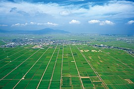 Echigo Plain
 Senkakuwan in Sado Island
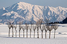 Paddy fields and mountains in Ojiya in winter


Cities
Twenty cities are located in Niigata Prefecture:
| Name | Area (km2) | Population | Map | |
|---|---|---|---|---|
| Rōmaji | Kanji | |||
| 阿賀野市 | 192.74 | 41,204 |  | |
| 五泉市 | 351.91 | 48,458 |  | |
| 糸魚川市 | 746.24 | 41,333 |  | |
| 上越市 | 973.81 | 189,430 |  | |
| 加茂市 | 133.72 | 25,971 |  | |
| 柏崎市 | 442.03 | 81,836 |  | |
| 南魚沼市 | 584.55 | 55,354 |  | |
| 見附市 | 77.91 | 39,908 |  | |
| 村上市 | 1,174.26 | 58,300 |  | |
| 妙高市 | 445.63 | 31,374 |  | |
| 長岡市 | 891.06 | 266,539 |  | |
| 新潟市 | 726.45 | 797,591 |  | |
| 小千谷市 | 155.19 | 34,704 |  | |
| 佐渡市 | 855.26 | 55,474 |  | |
| 三条市 | 431.97 | 95,706 |  | |
| 新発田市 | 533.1 | 96,236 |  | |
| 胎内市 | 264.89 | 28,495 |  | |
| 十日町市 | 590.39 | 53,333 |  | |
| 燕市 | 110.96 | 77,382 |  | |
| 魚沼市 | 946.76 | 35,027 |  | |
Towns and villages
These are the towns and villages in each district:
| Name | Area (km2) | Population | District | Type | Map | |
|---|---|---|---|---|---|---|
| Rōmaji | Kanji | |||||
| 阿賀町 | 952.89 | 10,386 | Higashikanbara District | Town |  | |
| 粟島浦村 | 9.78 | 353 | Iwafune District | Village | ||
| 出雲崎町 | 44.38 | 4,190 | Santō District | Town |  | |
| 刈羽村 | 26.27 | 4,578 | Kariwa District | Village |  | |
| 聖籠町 | 37.58 | 14,025 | Kitakanbara District | Town |  | |
| 関川村 | 299.61 | 5,291 | Iwafune District | Village |  | |
| 田上町 | 31.71 | 11,481 | Minamikanbara District | Town |  | |
| 津南町 | 170.21 | 9,349 | Nakauonuma District | Town |  | |
| 弥彦村 | 25.17 | 7,824 | Nishikanbara District | Village |  | |
| 湯沢町 | 357.29 | 7,926 | Minami-Uonuma District | Town |  | |
Mergers
List of Governor of Niigata Prefecture (from 1947)
|
|
Economy
Agriculture, forestry and fishing

The major industry in Niigata Prefecture is agriculture. Rice is the principal product, and among the prefectures of Japan Niigata is second only to Hokkaidō in rice output. The area around Uonuma is known for producing the Koshihikari variety, widely considered to be the highest-quality rice produced in Japan.
Rice-related industries are also very important to the prefectural economy. Niigata Prefecture is known throughout Japan for its high-quality sake, senbei, mochi, and arare. In sake production, the prefecture comes third after Gunma and Kyoto prefectures.
The prefecture was also the place of origin of the ornamental carp known as koi.
Niigata Prefecture produces the highest volume of azaleas and cut lilies in Japan, and is increasing the production of cut flowers and flower bulbs. Along with Toyama Prefecture, it produces the highest volume of tulips in the country.
Mining and manufacturing

Crude oil is produced in Niigata Prefecture, although Japan relies heavily on petroleum imported from other countries. Kerosene heaters are also produced for use in the cold Niigata winters.
Kinzan, on Sado Island, was an active gold mine until it was closed in 1989.
Sanjō and Tsubame produce 90 percent of all the silverware made in Japan. The two cities are second after Osaka in the production of scissors, kitchen knives, and wrenches.
Niigata Prefecture may have been the first area in Japan to produce knitted textiles, although the earliest products may have been imported from China. A nuclear power plant, which formerly had the highest energy output in the world,[citation needed] is located in the tiny village of Kariwa. It has been closed since the Fukushima Daiichi nuclear disaster.[5]
Demographics
| Year | Pop. | ±% p.a. |
|---|---|---|
| 1880 | 1,546,338 | — |
| 1890 | 1,693,727 | +0.91% |
| 1903 | 1,780,123 | +0.38% |
| 1913 | 1,911,308 | +0.71% |
| 1920 | 1,776,474 | −1.04% |
| 1925 | 1,849,807 | +0.81% |
| 1930 | 1,933,326 | +0.89% |
| 1935 | 1,995,777 | +0.64% |
| 1940 | 2,064,402 | +0.68% |
| 1945 | 2,389,653 | +2.97% |
| 1950 | 2,460,997 | +0.59% |
| 1955 | 2,473,492 | +0.10% |
| 1960 | 2,442,037 | −0.26% |
| 1965 | 2,398,931 | −0.36% |
| 1970 | 2,360,982 | −0.32% |
| 1975 | 2,391,938 | +0.26% |
| 1980 | 2,451,357 | +0.49% |
| 1985 | 2,478,470 | +0.22% |
| 1990 | 2,474,583 | −0.03% |
| 1995 | 2,488,364 | +0.11% |
| 2000 | 2,475,733 | −0.10% |
| 2005 | 2,431,459 | −0.36% |
| 2010 | 2,374,450 | −0.47% |
| 2015 | 2,305,098 | −0.59% |
| 2020 | 2,227,496 | −0.68% |
| source:[6] | ||
In the Census of 2003, Niigata ranked as the 14th most populous.
Culture

Food

Niigata is known for the following regional specialities:
- Uonuma Koshihikari rice
- Shōyu (soy sauce) and Yofu (western-style) katsudon
- Shōyu sekihan
- Noppe stew
- Wappa-meshi (seafood and rice steamed in a bamboo basket)
- Sasa-dango (mochi balls filled with red bean paste, seasoned with mugwort and wrapped in bamboo leaves)
- Poppo-yaki (steamed bread flavored with brown sugar)
- Hegi-soba (soba from the Uonuma and Ojiya areas, which uses a special kind of seaweed)
- "Tsubame-Sanjō ramen" (ramen made using thick udon-style noodles)
- Tochio aburage (aburaage is called "aburage" in Tochio)
- Kirazu (dishes using okara)
- Kakinomoto (edible chrysanthemums)
- Kanzuri (a special seasoning from Myōkō made by leaving chili peppers exposed on snow, then adding flour, salt and yuzu)
- Yasuda yogurt
Niigata in popular culture
- Snow Country (1947): a novel by Nobel laureate Yasunari Kawabata set in Yuzawa
- "Niigata Snow": a track on the LP Aida, released by Derek Bailey in 1980
- Kura: a film and TV series (1995) based on the 1993 book by Tomiko Miyao, an award-winning period piece about a Niigata family and its sake brewery
- Blue (1996): a manga about high school girls, set in Niigata City, adapted as a film in 2001
- Whiteout: an action film based on a novel published in 1995
- United States of Tara (2011): a comedy-drama series on Showtime; Kate is about to embark on a trip to teach English in Niigata when a flight attendant tells her that the only thing she will hopefully find in Niigata is "a life lesson and a bullet train back to Tokyo."
Tourism and sports
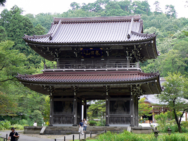
Much of the tourism in Niigata centers around skiing, especially in the alpine areas of Myōkō and Yuzawa, and going to onsen. Sado Island off the west coast of Niigata is accessible via ferry (taking one to two and a half hours) from Naoetsu or Niigata City.
Professional sports clubs include Albirex Niigata, a J-League Division 1 Football Club, and Niigata Albirex BB, a BJ (Basketball Japan) League team.
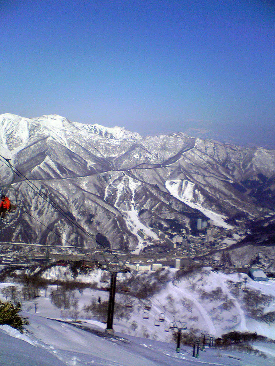
 Naeba ski resort in Yuzawa
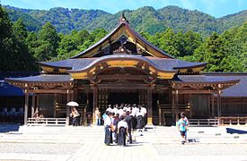 Yahiko Shrine
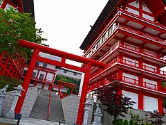 Hotokusan-inaritaisha shrine
 Hasegawa Family Residence
 Izumozaki-juku (Japanese historical highway Hokkokukaido)
 Matsunoyama Onsen
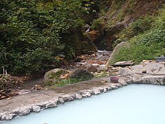
 Shukunegi district in Sado Island (Important Preservation Districts for Groups of Traditional Buildings)
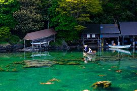 Tarai Bune in Sado Island
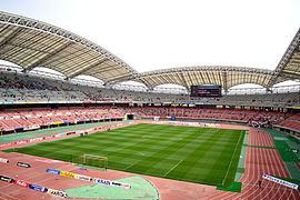 Bigswan Stadium


Festivals


- Tokamachi Snow Festival- February
- Murakami Taisai – July 6–7
- Iwafune Taisai – October 18–19, in Murakami
- Niigata Festival – August
- Niigata General Dancing Event -September 21–25
- Shirone Kite Festival – June
- Sanjo Kite Festival – June
- Nagaoka Festival (with fireworks) – August
- Niigata Tanrei Sake-no-Jin - March
- Echigo-Tsumari Festival - August and September (every third year)[7]
Education
Universities
- Niigata University
- Niigata University of International and Information Studies
- Niigata Sangyo University (Niigata Industrial University)
- Niigata University of Health and Welfare
- Niigata University of Pharmacy and Applied Life Sciences
- Niigata Institute of Technology
- Niigata University of Management
- Niigata College of Nursing
- Nippon Dental University
- Nagaoka University
- Nagaoka University of Technology
- Nagaoka Institute of Design
- International University of Japan
- Keiwa Gakuen University

Transport

Rail
- JR East
- Jōetsu Shinkansen
- Hokuriku Shinkansen
- Shin'etsu Line
- Hakushin Line
- Yahiko Line
- Echigo Line
- Jōetsu Line
- Uetsu Line
- Ban'etsu West Line
- Tadami Line
- Iiyama Line
- Yonesaka Line
- JR West
- Hokuriku Shinkansen
- Ōito Line
- Hokuetsu Express
- Hokuhoku Line
- Echigo Tokimeki Railway
- Myōkō Haneuma Line
- Nihonkai Hisui Line
Roads
Expressways
- E17 Kanetsu Expressway
- E18 Jōshinetsu Expressway
- E8 Hokuriku Expressway
- E49 Ban-etsu Expressway
- E7 Nihonkai Tōhoku Expressway
National highways
- Route 7 (Niigata—Shibata—Murakami—Sakata—Akita—Noshiro—Hirosaki—Aomori)
- Route 8 (Niigata—Nagaoka—Kashiwazaki—Jōetsu—Toyama—Kanazawa—Tsuruga—Kyoto)
- Route 17 (Nagaoka—Ojiya—Minamiuonuma—Takasaki—Nihonbashi of Tokyo)
- Route 18 (Jōetsu—Myōkō—Nagano—Karuizawa—Takasaki)
- Route 49 (Niigata—Aizuwakamatsu—Kōriyama—Iwaki)
- Route 113 (Niigata—Arakawa—Nan'yō—Shiroishi—Sōma)
- Route 116 (Niigata—Tsubame—Izumozaki—Kashiwazaki)
- Route 117 (Ojiya—Tōkamachi—Iiyama)
- Route 148 (Itoigawa—Ōmachi)
- Route 252
- Route 253
- Route 289
- Route 290
- Route 291
- Route 292
- Route 345
- Route 350 (Sado Island)
- Route 351
- Route 352
- Route 353
- Route 402
- Route 403
- Route 404
- Route 405
- Route 459
- Route 460
Ports
- Niigata Port – Ferry route to Sado Island (Ryotsu),[8] Tsuruga, Akita, Otaru and Tomakomai, with International Container hub port
- Ryotsu Port – Ferry route to Niigata
- Ogi Port - Ferry route to Naoetsu
- Naoetsu Port in Joetsu - Ferry route to Ogi
- Iwafune Port in Murakami- Ferry route to Awashima
Airports
Notable individuals
This section needs additional citations for verification. (January 2013) |
Politics and military
- Masako, Empress of Japan, former registered domicile (Honseki) was Murakami
- Uesugi Kenshin (1530–1578), daimyō in the Sengoku period
- Naoe Kanetsugu (1559–1620), samurai in the Sengoku period
- Horibe Yasubei (1670–1703), samurai in the Edo period
- Hachirō Arita (1884–1965), foreign minister, from Sado Island
- Maejima Hisoka (1835–1919), founder of the Japanese postal service, from Joetsu
- Masuda Takashi (1848–1938), creation of a general trading company, Mitsui Bussan. established a newspaper, Nihon Keizai Shimbun. from Sado Island
- Kita Ikki (1883–1937), nationalist author and intellectual, from Sado Island
- Sakae Ōsugi (1885-1923), anarchist, lived in Shibata
- Honma Masaharu (1887–1946) World War II lieutenant-general executed by the United States for war crimes committed in the Philippines
- Hitoshi Imamura (1886–1968) World War II General in the Imperial Japanese Army, from Shibata high school
- Isoroku Yamamoto (1884–1943), commander of the Japanese Imperial Navy, from Nagaoka
- Chiang Kai-shek (1887-1975), Chinese political and military leader, served in the Imperial Japanese Army from 1909 to 1911 in Joetsu (Takada)
- Ba Maw (1893-1977), Burmese political leader, active during the interwar and World War II, lived in Minamiuonuma (Ichiuchi)
- Kakuei Tanaka (1918–1993), prime minister, from Kashiwazaki
- Hisashi Owada (born 1932), diplomat and father of Crown Princess Masako, from Shibata
- Makiko Tanaka (born 1944), first female foreign minister, from Kashiwazaki
Arts and culture
- Zeami Motokiyo (1363– 1443), aesthetician, actor, and playwright, exile to Sado Island
- Ryōkan (1758–1831), Zen Buddhist monk and poet, from Izumozaki
- Etsu Inagaki Sugimoto, (1874–1950), autobiographer and novelist, Professor of literature and taught Japanese language, culture and history at Columbia University, from Nagaoka
- Yaichi Aizu (1881–1956), poet, calligrapher and historian, from Niigata City
- Kokei Kobayashi (1883–1957), Nihonga painter, from Joetsu
- Mimei Ogawa (1882–1961), author of short stories, children's stories, and fairy tales, from Joetsu
- Koganei Yoshikiyo (1859–1944), anatomist and anthropologist, from Nagaoka
- Kyusaku Ogino (1882-1975), doctor specializing in obstetrics and gynecology, Niigata Takeyama Hospital
- Kinichiro Sakaguchi(1897 – 1994), agricultural chemist and microbiologist, from Joetsu
- Takashi Amano(1954-2015), photographer and aquarist, from Niigata
- Tetsuji Morohashi(1883– 1982) chief editor of the Dai Kan-Wa jiten, a comprehensive dictionary of Chinese characters, from Sanjo
- Tetsuo Harada (born 1949 Niitsu-shi), sculptor working in Paris France
- Tsuchida Bakusen (1887–1936), Japanese painter, from Sado
- Fubō Hayashi (1900–1935), novelist from Sado Island
- Inoue Enryō (1858–1919), Buddhist philosopher, from Nagaoka
- Junzaburō Nishiwaki (1894–1982), Japanese poet and literary critic, from Ojiya
- Daigaku Horiguchi (1892-1981), poet and translator of French literature, from Nagaoka
- Makoto Aida (born 1965), Artist, from Niigata City
- Donald Keene (born 1922), Japanese scholar, historian, teacher, writer and translator of Japanese literature, Honorary Citizen of Kashiwazaki
- Kodo (taiko group), Based in Sado
Actors, Actresses, Singers
- Ken Watanabe (born 1959), stage, TV and film actor, from Niigata
- Princess Tenko (born 1959), magician, from Joetsu
- Mina Fujii (born 1998), actress
- Mikie Hara (born 1987), gravure idol and actress, from Murakami
- Fumika Baba (born 1995), actress and model, from Niigata City
- Maya Kobayashi (born 1979), journalist and newscaster, from Ojiya
- Mao Kobayashi (actress) (born 1982), newscaster and former actress, from Ojiya
- Miyuki Koizumi (born 1982), Model
- Kazuyuki Sekiguchi (born 1955), bass player for the rock group Southern All Stars, from Agano
- Makoto Ogawa (born 1987), former member of Morning Musume, actor and model, from Kashiwazaki
- Koharu Kusumi (born 1992), former member of Morning Musume, actor and model, from Washima
- Hitomi Saito (born 1981), former singer of leader of Melon Kinenbi, from Niigata City
- Suneohair (born 1971), singer, from Nagaoka
- Yasuyuki Okamura (born 1965), from Niigata Higashi High School
- Double (singer),Japanese R&B singer
- Negicco Based on Niigata City, Niigata
- NGT48 Based on Niigata City, Niigata
Pop culture, manga, voice actors
- One (manga artist) (1986), mangaká, from Niigata City
- Yoshifumi Kondō (1950–1998), animator, from Gosen
- Hiroyuki Yamaga (born 1962), anime director and producer, and a founding member of the animation studio Gainax, from Niigata City
- Daisuke Hirakawa (born 1973), voice actor
- Ryō Hirohashi (born 1977), voice actress, from Nagaoka
- Yoko Ishida (born 1973), singer, from Niigata City
- Rumi Kasahara (born 1970), voice actress, from Itoigawa
- Makoto Kobayashi (born 1958), manga artist, from Niigata City
- Közi (born 1972), rock musician
- Haruo Minami (1923–2001), enka singer, from Nagaoka
- Hitomi Nabatame (born 1976), voice actress, from Sado Island
- Tatsuyuki Nagai (born 1976), anime director
- Kazuto Nakazawa (born 1968), animator
- Kenichi Suzumura (born 1974), voice actor
- Kiriko Nananan (born 1972), manga artist, from Tsubame
- Yukari Nozawa (born 1957), actor and voice actor
- Takeshi Obata (born 1969), manga artist, from Niigata City
- Etsushi Ogawa (born 1969), manga artist
- Ikue Otani (born 1965), voice actress, from Kashiwazaki
- Ango Sakaguchi (1906–1955), novelist and essayist, from Niigata City
- Daisuke Sakaguchi (born 1973), voice actor, from Kashiwazaki
- Shuichi Shigeno (born 1958), manga artist, from Tōkamachi
- Bin Shimada (born 1954), voice actor, from Niigata City
- Kunio Shimizu (1936–2021), playwright from Niigata
- Motoei Shinzawa (born 1958), manga artist, from Kashiwazaki
- Yōko Sōmi (born 1965), voice actress
- Rumiko Takahashi (born 1957), manga artist, from Niigata City
- Kazuya Tsurumaki (born 1966), animator, from Gosen
- Hajime Watanabe (born 1957), animator
- Nobuhiro Watsuki (born 1970), manga artist, from Nagaoka
- Hiroki Yagami (born 1967), manga artist, from Kashiwazaki
- Akiko Yajima (born 1967), voice actress, from Kashiwazaki
- Kimio Yanagisawa (born 1948), manga artist, from Gosen
- Keiko Yokozawa (born 1952), voice actress, from Niigata City
Sports
- Shiro Saigo(1866 – 1922), Judo, lived in Aga (Tsugawa), lived in 1869-1882
- Haguroyama Masaji (1914–1969), sumo wrestler from Nakanokuchi who was yokozuna for 12 years and three months; an all-time record
- Shohei Baba (1938–1999), Japanese professional wrestler, from Sanjō
- Sawao Kato (born 1946), winner of 12 Olympic medals in gymnastics
- Killer Khan (born 1947), professional wrestler, from Tsubame
- Ayumu Hirano (born 1998), snowboarder, from Murakami
- Ayana Onozuka (born 1988), freestyle skier, from Minamiuonuma
- Kentaro Minagawa (born 1977), alpine skier, from Yuzawa
- Junko Hoshino (born 1989), freestyle skier, from Nagaoka
- Reruhi Shimizu (born 1993), ski jumper, from Myoko
- Mai Nakamura (born 1979), swimmer, from Nagaoka
- Gōtoku Sakai (born 1991), footballer (2015– Hamburger SV), from Sanjo
- Yujiro Takahashi (born 1981), professional wrestler from Niigata City.
See also
- Niigata Minamata disease
- Wara art
Notes
- Nussbaum, Louis-Frédéric. (2005). "Niigata-ken" in Japan Encyclopedia, p. 711, p. 711, at Google Books
- Nussbaum, "Niigata" at p. 711, p. 711, at Google Books
- Nussbaum, "Provinces and prefectures" at p. 780, p. 780, at Google Books
- "General overview of area figures for Natural Parks by prefecture" (PDF). Ministry of the Environment. 1 April 2014. Retrieved 14 February 2015.
- "Japanese Anti-nuclear Candidate Wins Election at Site of World's Biggest Atomic Power Station". The Guardian. Reuters. 17 October 2016. Retrieved 17 October 2016.
- Statistics Bureau of Japan
- "Triennale 2015 - Echigo-Tsumari Art Field". www.echigo-tsumari.jp.
- "Access Map | 佐渡汽船公式サイト" (in Japanese). Retrieved 2021-09-03.
References
- Nussbaum, Louis-Frédéric and Käthe Roth. (2005). Japan encyclopedia. Cambridge: Harvard University Press. ISBN 978-0-674-01753-5; OCLC 58053128
External links
- Niigata Prefecture Official Website (in Japanese)
- Niigata Prefecture Official Website (in English)
Regions and administrative divisions of Japan | |||||||||||||||||
|---|---|---|---|---|---|---|---|---|---|---|---|---|---|---|---|---|---|
| |||||||||||||||||
| Regions |  | ||||||||||||||||
| 47 Prefectures |
| ||||||||||||||||
| |||||||||||||||||
Authority control | |
|---|---|
| General | |
| National libraries | |
| Other |
|
На других языках
[de] Präfektur Niigata
Die Präfektur Niigata (jap. 新潟県 .mw-parser-output .Latn{font-family:"Akzidenz Grotesk","Arial","Avant Garde Gothic","Calibri","Futura","Geneva","Gill Sans","Helvetica","Lucida Grande","Lucida Sans Unicode","Lucida Grande","Stone Sans","Tahoma","Trebuchet","Univers","Verdana"}Niigata-ken) ist eine der Präfekturen Japans. Sie liegt an der Küste zum Japanischen Meer der Hauptinsel Honshū und umfasst über 90 weitere Inseln, darunter mit Sado-shima eine der größten Inseln des Landes. Die gleichnamige Stadt Niigata (Niigata-shi) ist Sitz der Präfekturverwaltung.- [en] Niigata Prefecture
[ru] Ниигата (префектура)
Ниигата (яп. 新潟県 Ниигата-кэн) — префектура, расположенная в регионе Тюбу на острове Хонсю, Япония. Административный центр префектуры — город Ниигата. Площадь префектуры составляет 12 583,83 км²[2], население — 2 315 447 человек (1 августа 2014)[3], плотность населения — 184,00 чел./км².Другой контент может иметь иную лицензию. Перед использованием материалов сайта WikiSort.org внимательно изучите правила лицензирования конкретных элементов наполнения сайта.
WikiSort.org - проект по пересортировке и дополнению контента Википедии