world.wikisort.org - Japan
Sakata (酒田市, Sakata-shi) is a city located in Yamagata Prefecture, Japan. As of 1 October 2015[update], the city had an estimated population of 106,244 in 39320 households,[1] and a population density of 180 people per km2. The total area of the city is 602.97 square kilometres (232.81 sq mi).
This article needs additional citations for verification. (December 2015) |
Sakata
酒田市 | |
|---|---|
City | |
 Sakata Festival, held annually in May | |
 Flag  Seal | |
 Location of Sakata in Yamagata Prefecture | |
 Sakata | |
| Coordinates: 38°54′52.1″N 139°50′11.2″E | |
| Country | Japan |
| Region | Tōhoku |
| Prefecture | Yamagata |
| Government | |
| • Mayor | Itaru Maruyama (from September 2015) |
| Area | |
| • Total | 602.97 km2 (232.81 sq mi) |
| Population (February 1, 2021) | |
| • Total | 99,341 |
| • Density | 160/km2 (430/sq mi) |
| Time zone | UTC+9 (Japan Standard Time) |
| Phone number | 0234-22-5111 |
| Address | 2-2-45, Honchō, Sakata-shi, Yamagata-ken 998-8540 |
| Climate | Cfa |
| Website | Official website |
| Symbols | |
| Bird | Aquila chrysaetos |
| Flower | Hemerocallis |
| Tree | Zelkova |
Geography

Sakata is located in the coastal plains of the northwest corner of Yamagata Prefecture, bordered by the Sea of Japan to the west, and by Akita Prefecture to the north. The Mogami River runs through the city, which has Mount Chōkai on its northern border. The inhabited island of Tobishima, approximately 38 kilometres (24 mi) off the coast of the mainland, is within the administrative borders of the city. The island, as well as part of the mainland portion of the city, is within the borders of the Chōkai Quasi-National Park[2]
Neighboring municipalities
- Akita Prefecture
- Yurihonjō
- Nikaho
- Yamagata Prefecture
Climate
Sakata has a Humid continental climate (Köppen climate classification Cfa) with large seasonal temperature differences, with warm to hot (and often humid) summers and cold (sometimes severely cold) winters. Precipitation is significant throughout the year, but is heaviest from August to October. The average annual temperature in Sakata is 13.0 °C (55.4 °F). The average annual rainfall is 1,986.8 mm (78.22 in) with November as the wettest month. The temperatures are highest on average in August, at around 25.5 °C (77.9 °F), and lowest in January, at around 1.9 °C (35.4 °F).[3]
| Climate data for Sakata (1991−2020 normals, extremes 1937−present) | |||||||||||||
|---|---|---|---|---|---|---|---|---|---|---|---|---|---|
| Month | Jan | Feb | Mar | Apr | May | Jun | Jul | Aug | Sep | Oct | Nov | Dec | Year |
| Record high °C (°F) | 15.5 (59.9) |
21.6 (70.9) |
22.6 (72.7) |
28.6 (83.5) |
31.3 (88.3) |
34.2 (93.6) |
37.7 (99.9) |
40.1 (104.2) |
36.8 (98.2) |
32.1 (89.8) |
24.8 (76.6) |
19.0 (66.2) |
40.1 (104.2) |
| Average high °C (°F) | 4.5 (40.1) |
5.2 (41.4) |
8.9 (48.0) |
14.8 (58.6) |
20.3 (68.5) |
24.1 (75.4) |
27.6 (81.7) |
29.7 (85.5) |
25.8 (78.4) |
19.8 (67.6) |
13.6 (56.5) |
7.6 (45.7) |
16.8 (62.3) |
| Daily mean °C (°F) | 1.9 (35.4) |
2.2 (36.0) |
5.1 (41.2) |
10.2 (50.4) |
15.7 (60.3) |
20.0 (68.0) |
23.8 (74.8) |
25.5 (77.9) |
21.6 (70.9) |
15.6 (60.1) |
9.7 (49.5) |
4.5 (40.1) |
13.0 (55.4) |
| Average low °C (°F) | −0.6 (30.9) |
−0.8 (30.6) |
1.4 (34.5) |
5.8 (42.4) |
11.6 (52.9) |
16.5 (61.7) |
20.7 (69.3) |
22.0 (71.6) |
17.8 (64.0) |
11.6 (52.9) |
5.9 (42.6) |
1.6 (34.9) |
9.5 (49.0) |
| Record low °C (°F) | −16.9 (1.6) |
−12.8 (9.0) |
−9.9 (14.2) |
−3.7 (25.3) |
−0.2 (31.6) |
7.5 (45.5) |
9.5 (49.1) |
13.2 (55.8) |
7.0 (44.6) |
1.4 (34.5) |
−5.1 (22.8) |
−12.5 (9.5) |
−16.9 (1.6) |
| Average precipitation mm (inches) | 177.7 (7.00) |
118.4 (4.66) |
111.1 (4.37) |
103.6 (4.08) |
122.6 (4.83) |
125.3 (4.93) |
218.7 (8.61) |
205.6 (8.09) |
176.2 (6.94) |
188.6 (7.43) |
222.0 (8.74) |
217.0 (8.54) |
1,986.8 (78.22) |
| Average snowfall cm (inches) | 85 (33) |
62 (24) |
20 (7.9) |
trace | 0 (0) |
0 (0) |
0 (0) |
0 (0) |
0 (0) |
0 (0) |
3 (1.2) |
40 (16) |
211 (83) |
| Average precipitation days (≥ 1.0 mm) | 24.1 | 19.1 | 17.1 | 12.4 | 11.2 | 10.2 | 12.6 | 11.3 | 12.8 | 14.7 | 19.3 | 23.5 | 188.3 |
| Average snowy days (≥ 1 cm) | 18.3 | 15.2 | 5.8 | 0.3 | 0 | 0 | 0 | 0 | 0 | 0 | 0.5 | 9.2 | 49.3 |
| Average relative humidity (%) | 72 | 70 | 67 | 67 | 71 | 75 | 79 | 76 | 75 | 72 | 71 | 71 | 72 |
| Mean monthly sunshine hours | 36.8 | 60.1 | 115.1 | 169.0 | 194.7 | 181.9 | 159.5 | 199.5 | 156.8 | 136.1 | 84.3 | 41.7 | 1,538.8 |
| Source: Japan Meteorological Agency[4][3] | |||||||||||||
Demographics
Per Japanese census data,[5] the population of Sakata has declined in recent decades.
| Year | Pop. | ±% |
|---|---|---|
| 1920 | 88,948 | — |
| 1930 | 99,112 | +11.4% |
| 1940 | 99,103 | −0.0% |
| 1950 | 125,734 | +26.9% |
| 1960 | 127,229 | +1.2% |
| 1970 | 120,212 | −5.5% |
| 1980 | 125,622 | +4.5% |
| 1990 | 122,850 | −2.2% |
| 2000 | 121,614 | −1.0% |
| 2010 | 111,151 | −8.6% |
| 2020 | 100,273 | −9.8% |
History
The area of present-day Sakata was the location of the provincial capital of ancient Dewa Province, although the precise location has yet to be discovered by archaeologists. A port at the mouth of the Mogami River is known to have existed since the Kamakura period. Although silting rendered it less important in the Muromachi period, the area developed as a major center for the kitamaebune coastal trade during the Edo period. By the early Meiji period, the Honma clan, a local merchant clan, dominated trade and emerged as the largest landholder in Japan.[citation needed] Traces of their powerful influence on Sakata City can still be seen across the city. This includes the Honma Museum and The Honma Gardens located in the downtown area.[6]
With the establishment of the modern municipalities system after the start of the Meiji period, the area was organized as Sakata Town under Akumi District, Yamagata Prefecture in 1878. Approximately 80% of the town was destroyed by the 1894 Shōnai earthquake and subsequent fires. The modern city of Sakata was founded on April 1, 1933.
World War II
The city largely escaped damage during World War II, save for a lone air raid on its port district on August 10, 1945, which left 30 people dead or missing.
On September 20, 1944, over 200 British prisoners of war transfer to the newly created POW camp, known officially as Sakata Branch Camp (Sendai 9-B). The British would later be joined by American, Dutch and Australian POW's. The camp was liberated in September 1945.[7] The camp was originally established as Tokyo 22B, jurisdictional transferred to Sendai on April 14, 1945. The camp roster included:
- 15 Americans, no deaths
- 248 British, 13 deceased
- 5 Dutch, no deaths
- 26 Australians, 5 deceased
Most of the POW's were transferred from camps in the Osaka and Tokyo area and many had survived the sinking of the steamships Kachidoki Maru and Rakuyo Maru. The men were used as forced labor at the Port of Sakata and some worked for NITTSU, also known as Nippon Express, still operating in Japan today.
Post World War II
On October 29, 1976, Sakata suffered from a major fire which gutted 22.5 hectares of its city center, destroying 1,774 buildings and injuring 964 people (and one fatality).
On November 1, 2005, the towns of Hirata, Matsuyama and Yawata (all from Akumi District) were merged into Sakata.
Government

Higashine has a mayor-council form of government with a directly elected mayor and a unicameral city legislature of 28 members. The city contributes five members to the Yamagata Prefectural Assembly. In terms of national politics, the city is part of Yamagata District 3 of the lower house of the Diet of Japan.
Economy
The economy of Sakata is based on light manufacturing, agriculture and commercial fishing. The Sakata Kyodo Thermal Power Station is a fossil-fueled power station operated by a joint venture of Tohoku Electric and Sumitomo Aluminum in the city.
Major employers include Maeta Seikan,[8] which makes concrete products and has played a major role in supporting reconstruction after the 2011 Tōhoku earthquake and tsunami, Kao, a chemical and cosmetics company[9] and the electronics company, Seiko Epson. Seiko Epson uses the local Shonai Airport for weekly employee charter flights to and from Matsumoto, Nagano since 1997.
Education
Universities
- Tohoku University of Community Service and Science
High schools
- Yamagata Prefectural Sakata Higashi High School
- Tenshin Gakuen High School
- Sakata Minami High School
- Sakata Nishi High School
- Sakata Koryo High School
Junior high schools
- Sakata First Junior High School
- Sakata Second Junior High School
- Sakata Third Junior High School
- Sakata Fourth Junior High School
- Sakata Fifth Junior High School
- Sakata Sixth Junior High School
- Sakata Tobishima Junior High School
- Sakata Hirata Junior High School
- Sakata Chokai Junior High School
- Sakata Yawata Junior High School
- Sakata Matsuyama Junior High School
Elementary schools
- Sakata Takusei Elementary School
- Sakata Hamada Elementary School
- Sakata Wakahama Elementary School
- Sakata Fujimi Elementary School
- Sakata Kijo Elementary School
- Sakata Matsubara Elementary School
- Sakata Konan Elementary School
- Sakata Shoryo Elementary School
- Sakata Izumi Elementary School
- Sakata Tobishima Elementary School
- Sakata Nishi Arase Elementary School
- Sakata Niibori Elementary School
- Sakata Hirono Elementary School
- Sakata Hamanaka Elementary School
- Sakata Kuromori Elementary School
- Sakata Tozaka Elementary School
- Sakata Miyanoura Elementary School
- Sakata Higashi Hirata Elementary School
- Sakata Naka Hirata Elementary School
- Sakata Kita Hirata Elementary School
- Sakata Chokai Elementary School
- Sakata Minami Yuza Elementary School
- Sakata Ichijyo Elementary School
- Sakata Yawata Elementary School
- Sakata Osawa Elementary School
- Sakata Nikko Elementary School
- Sakata Jimikoya Elementary School
- Sakata Matsuyama Elementary School
- Sakata Naigo Elementary School
- Sakata Tazawa Elementary School
- Sakata Minami Hirata Elementary School
Transportation

Airports
Railway
![]() East Japan Railway Company - Uetsu Main Line
East Japan Railway Company - Uetsu Main Line
- Sagoshi - Higashi-Sakata - Sakata - Mototate - Minamichōkai
![]() East Japan Railway Company - Rikuu West Line
East Japan Railway Company - Rikuu West Line
Highway
 Nihonkai-Tōhoku Expressway
 Yamagata Expressway: (Sakata, Sakata Minato, and Shōnai Airport interchanges)
 National Route 7
 National Route 47
 National Route 112
 National Route 344
 National Route 345
Seaports
- Port of Sakata
Health care
- Prefectural Nihonkai Hospital
- Municipal Sakata Hospital
- Municipal Yawata Hospital
- Homma Hospital
Media
Cinemas
- Sakata Minato-za
Newspaper
- Shonai Nippo (荘内日報)
Television
- NHK Sakata Broadcast Station
- TV-U Yamagata Sakata Station
- Sakata Cable Television Station
Radio
Sakata FM Radio
Sister city relations
- Tangshan, Hebei, China[10] – since July 26, 1990
- Zheleznogorsk-Ilimsky, Irkutsk Oblast, Russia[10] – since October 8, 1979
- Delaware, Ohio, United States - since April 19, 2017[11]
Local attractions
Art and historical museums
- Domon Ken Photography Museum - A museum dedicated to Ken Domon, one of the most famous photographers in Japanese history. This is also the only museum in the world that is dedicated to a single photographer.[citation needed]
- Homma Museum of Art - The Honma Museum of Art is a converted old villa which once belonged to the Honma clan. The villa was used by the lords of the Sakai family in the Edo period. Some of the fine arts items in the museum's collection were donated by other clans in Japan, other furniture and fixings belonged to the Honma clan. The museum has a garden from which Mount Chokai can be seen.[12]
- The Historic Abumiya Residence - This museum is a restored home of one of the most famous merchant families in Sakata City. During the 1800s, this city played a key role in domestic trade within Japan. The Abumiya Residence is open for visitors to see how merchants conducted business and how the servants for this family supported them behind the scenes.[13]
- Sakata City Museum of Art - Contains a permanent collection which mainly focuses on the work of sculptor, Takahashi Go and painter, Saito Chozo. The museum is located 20 minutes from Sakata Station and has views of nearby Mount Chōkai.[14]
- Dewa-yushinkan - A Tea House complex located beside Sakata City Museum of Art.[15] It was built in 1994 and has a traditional Japanese design. [16]
- Somaro - A traditional Japanese restaurant dating to the Edo period. The culture of Maiko dancing in Sakata is a result of the city's close trading relationship with Osaka and Kyoto. The building has been carefully renovated and contains many traditional features. It also features an art gallery with the personal collection of Hirata Bokujo, a large pork company that is based in Sakata City.[17]
- Sake Museum
Famous and historical sites
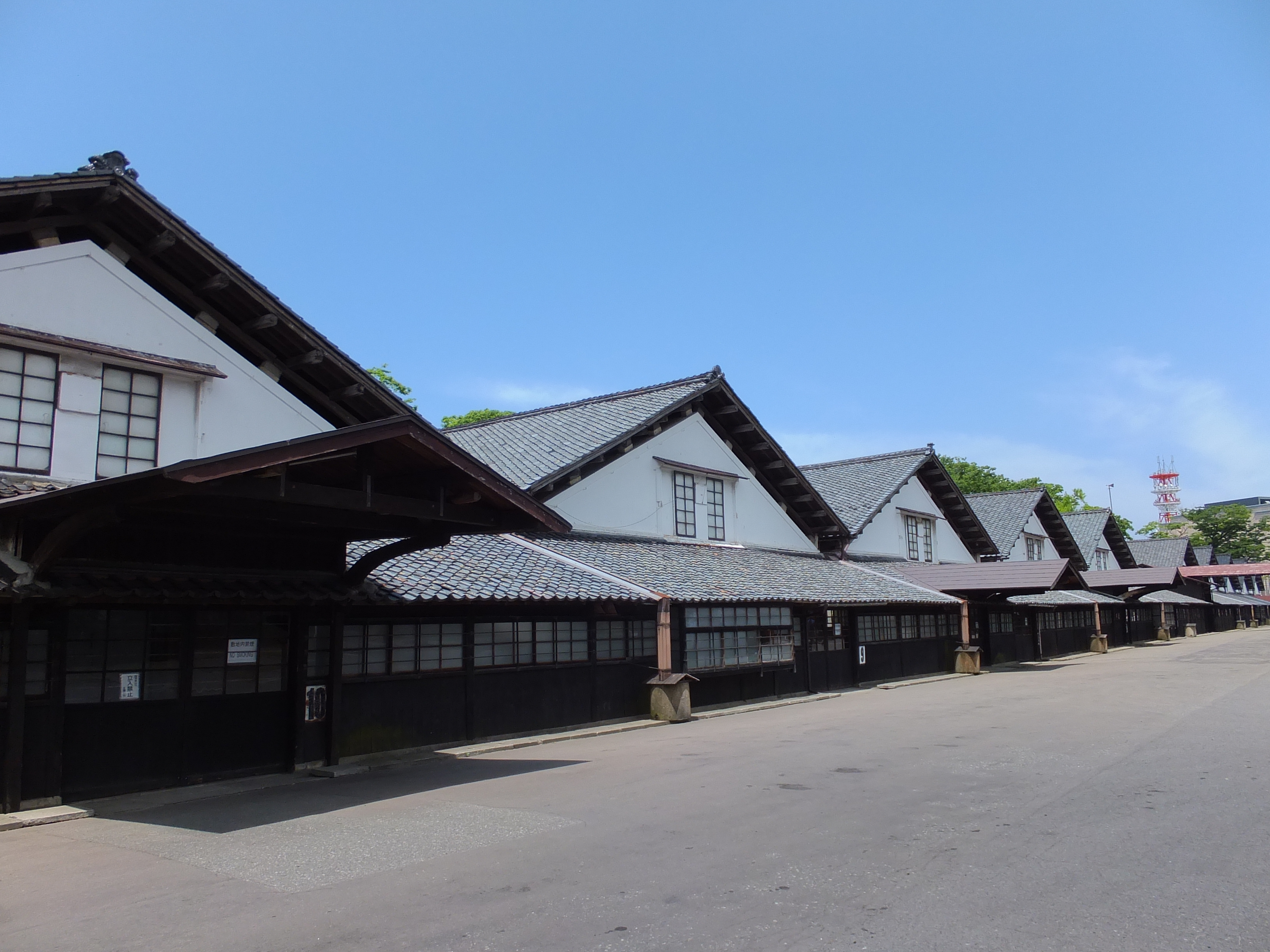
- Sankyo Storehouse - This kura was built in 1893 to store rice.[18] On the storehouse's southern side, there is a line of 41 Zelkova trees, which were planted over 150 years ago to help keep the temperature of the storehouses low during the hot summer months.[19] The modern day storehouse contains a small museum with information regarding the history and culture of Sakata, a restaurant and a souvenir shop which sells local foods and sake.[18]
- Hiyoriyama Park - A park located close to the city center which offers panoramic views of the Port of Sakata. There are over 400 cherry trees in the park and it is home to a cherry blossom festival in late April.[20]
- The Historical Honma Residence - A historic residence of a famous merchant clan. This home is located nearby the Historic Abumiya Residence and also has many rooms and displays.
- The Kinowa Wall Site
- The Historical Shirasaki Clinic
Shrines and temples
- Jofuku Temple
- Kaikou-ji Temple – Shingon Buddhism temple located in the centre of Sakata near Hiyoriyama Park. The temple contains the remains of two priests who starved themselves to death through a process of self-mummification called sokushinbutsu.[21]
- Jichi-in Temple – a Buddhist temple at the heart of Sakata City located right next to Hiyoriyama Park and the historic entertainment district of this port city. This temple offers zazen meditation led by the head priest who can speak English.[22]
Festivals
This section may require copy editing for grammar, style, cohesion, tone, or spelling. (June 2022) |
- Sakata Festival, A major traditional festival, which official started in 1609, which current name in 1976, change from Sakata Sanoh Festival, that held every 19 to 21, May, not interrupt in volcano erupt in Mount Chōkai in 1801, 1894 Shōnai earthquake, 1796 and 1976 Great Fire in Sakata, World War I and World War II, however, interrupt in 2020 and 2021, due prevention to COVID-19 of worldwide pandemics.[citation needed]
Culture
Sakata Festival is a historical festival held every year in the center of the city between May 19 and May 21. The first festival was held in 1609 during the Edo period. In the past, it was called Sannou Festival. However, after a large fire damaged much of Sakata in 1976, the festival became a memorial event and was renamed Sakata Festival. There is a large parade in the central streets of the city, which features festival floats and dancers from schools, local companies and community organisations. Huge 'shishi gashira' (lion heads) are symbols of the festival. It is said that children chewed by the shishi gashira will become smart and healthy. About 350 stalls line the side of the main street selling snacks, drinks and crafts.[23]
Sakata was the shooting location for the following movies:
- Okuribito (English title Departures), 2008, winner of the Oscar for best foreign film.[24] Set in present time, a newly unemployed cellist takes a job preparing the dead for funerals.
- Silk, 2007, a film set in the 19th century, about a silkworm merchant and his love life, based on the novel by Alessandro Baricco
- Oshin, 2013, a film about the life of a young girl named Oshin who grew up in poverty in the Sakata region. The film was directed by Shin Togashi.[25]
Notable people
This section does not cite any sources. (November 2013) |
- Teiji Honma, ice hockey goaltender
- Ken Domon, photographer
- Kumiko Ikeda, long jumper
- Kinnosuke Ogura, mathematician
- Shūmei Ōkawa, nationalist author and politician
- Seiko Shimakage, volleyball player and golfer
- Homma Munehisa, legendary 18th century rice trader
- Haruo Nakajima, Japanese actor, best known for portraying Godzilla from the 1950s through the early 1970s
References
- Sakata City official statistics (in Japanese)
- "Natural Parks of Yamagata Prefecture" (PDF) (in Japanese). Yamagata Prefecture.[permanent dead link]
- 気象庁 / 平年値(年・月ごとの値). JMA. Retrieved March 26, 2022.
- 観測史上1~10位の値(年間を通じての値). JMA. Retrieved March 26, 2022.
- Sakata population statistics
- "Sakata City Yamagata Japan".
- "Sendai POW Camp #9-B Sakata".
- "前田製管(株) - マイナビ2015". mynavi.jp. Retrieved 24 March 2015.[permanent dead link]
- "Sakata Plant". kao.com. Retrieved 24 March 2015.
- "International Exchange". List of Affiliation Partners within Prefectures. Council of Local Authorities for International Relations (CLAIR). Archived from the original on 22 December 2015. Retrieved 21 November 2015.
- "Delaware, Sakata officially become sister cities". The Delaware Gazette. Retrieved 2017-07-12.
{{cite news}}: CS1 maint: others (link) - "The Honma Museum of Art - Sakata - Tohoku - Japan Travel Guide and Information - att.JAPAN". att.JAPAN. Archived from the original on 2015-04-02. Retrieved 24 March 2015.
- "Abumiya | Sakata | The Hidden Japan". Yamagata | Shonai | The Hidden Japan. Retrieved 2019-06-09.
- "Sakata City Museum of Art".
- "数寄屋・書院建築/(株)安井杢工務店:建築作品". Archived from the original on 2015-04-02. Retrieved 2015-03-31.
- "出羽遊心館|歴史文化を学ぶ|観光スポット|酒田さんぽ". Archived from the original on 2016-03-05. Retrieved 2015-03-31.
- Japan National Tourism Organization. "Sakata Area - Japan National Tourism Organization". jnto.go.jp. Retrieved 24 March 2015.
- "Sakata City — 酒田市". Archived from the original on 2015-04-02. Retrieved 2015-03-27.
- "山居倉庫|観光スポット|酒田さんぽ". Archived from the original on 2018-04-26. Retrieved 2015-03-27.
- "Archived copy". Archived from the original on 2015-04-02. Retrieved 2015-03-27.
{{cite web}}: CS1 maint: archived copy as title (link) - "Sokushinbutsu – Japanese Mummies – Japan Reference (JREF)". Japan Reference (JREF). Retrieved 24 March 2015.
- "Jichi-in Temple | The Hidden Japan". thehiddenjapan. Retrieved 2020-01-23.
- "酒田まつり|イベント|酒田さんぽ". Archived from the original on 2018-04-28. Retrieved 2015-03-24.
- 2009 Best Foreign Film Imdb.com
- "Oshin (2013)". IMDb.
External links
English Information https://www.thehiddenjapan.com/sakata
- Official Website (in Japanese)
- Sakata Sightseeing Guide(Japanese)
- Sightseeing guide(English)
Yamagata (capital) | ||
| Core city | ||
| Cities | ||
| Districts |
| |
List of mergers in Yamagata Prefecture | ||
Authority control | |
|---|---|
| General | |
| National libraries | |
| Other |
|
На других языках
[de] Sakata
Sakata (japanisch 酒田市, -shi) ist eine Küstenstadt in der Präfektur Yamagata im Nordwesten von Honshū, der Hauptinsel von Japan.- [en] Sakata, Yamagata
[es] Sakata (Yamagata)
Sakata (酒田市, Sakata-shi?) es una ciudad de la prefectura de Yamagata, en Japón. La ciudad fue fundada el 1 de abril de 1933. La población es de 116.883 habitantes para una superficie de 602,74 km² (2006).[ru] Саката (город)
Сака́та[1] (яп. 酒田市 Саката-си) — город в Японии, находящийся в префектуре Ямагата. Площадь города составляет 602,79 км²[2], население — 106 494 человека (1 августа 2014)[3], плотность населения — 176,67 чел./км².Другой контент может иметь иную лицензию. Перед использованием материалов сайта WikiSort.org внимательно изучите правила лицензирования конкретных элементов наполнения сайта.
WikiSort.org - проект по пересортировке и дополнению контента Википедии