world.wikisort.org - Japan
Ōkura (大蔵村, Ōkura-mura) is a village in Yamagata Prefecture, Japan. As of January 2020, the village has an estimated population of 3044, and a population density of 14 persons per km2. The total area is 211.59 square kilometres (82 sq mi).
Ōkura
大蔵村 | |
|---|---|
Village | |
 Ōkura Village Hall | |
 Flag  Seal | |
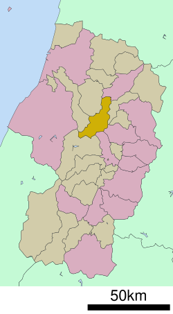 Location of Ōkura in Yamagata Prefecture | |
 Ōkura | |
| Coordinates: 38°42′14.8″N 140°13′49.3″E | |
| Country | Japan |
| Region | Tōhoku |
| Prefecture | Yamagata |
| District | Mogami |
| Area | |
| • Total | 211.59 km2 (81.70 sq mi) |
| Population (January 2020) | |
| • Total | 3,044 |
| • Density | 14/km2 (37/sq mi) |
| Time zone | UTC+9 (Japan Standard Time) |
| Phone number | 0233-75-2111 |
| Address | 2528 Kiyomizu, Ōkura-mura, Mogami-gun, Yamagata-ken 999-0212 |
| Climate | Cfb/Dfb |
| Website | Official website |
| Symbols | |
| Bird | Copper pheasant |
| Flower | Japanese gentian |
| Tree | Japanese beech |

Geography
Ōkura is located in a mountainous north-central eastern Yamagata Prefecture, and includes Mount Gassan within its borders. The Mogami River runs through the village. The area is known for extremely heavy snows in winter. Its highest accumulation of snow recorded is 414 cm, second place in Japan after Sukayu Onsen in Aomori.[citation needed] Snow typically starts in November, and starts piling up on the ground by early December. The snow will usually stop by early May, but will not completely melt until mid-June. Similar to Sukayu Onsen, snowfalls of 50 to 100 cm in a single day are not uncommon at all.[citation needed]
Neighboring municipalities
Climate
Ōkura has a Humid continental climate (Köppen climate classification Cfa) with large seasonal temperature differences, with warm to hot (and often humid) summers and cold (sometimes severely cold) winters. Precipitation is significant throughout the year, but is heaviest from August to October. The average annual temperature in Ōkura is 9.2 °C (48.6 °F). The average annual rainfall is 2,844.8 mm (112.00 in) with December as the wettest month. The temperatures are highest on average in August, at around 21.9 °C (71.4 °F), and lowest in January, at around −1.8 °C (28.8 °F).[1]
| Climate data for Hijiori Onsen, Ōkura (1991−2020 normals, extremes 1976−present) | |||||||||||||
|---|---|---|---|---|---|---|---|---|---|---|---|---|---|
| Month | Jan | Feb | Mar | Apr | May | Jun | Jul | Aug | Sep | Oct | Nov | Dec | Year |
| Record high °C (°F) | 11.8 (53.2) |
17.3 (63.1) |
18.2 (64.8) |
26.3 (79.3) |
30.4 (86.7) |
30.5 (86.9) |
33.4 (92.1) |
35.3 (95.5) |
32.4 (90.3) |
27.4 (81.3) |
21.9 (71.4) |
17.7 (63.9) |
35.3 (95.5) |
| Average high °C (°F) | 1.1 (34.0) |
1.8 (35.2) |
5.4 (41.7) |
11.7 (53.1) |
19.1 (66.4) |
22.7 (72.9) |
25.7 (78.3) |
27.1 (80.8) |
23.0 (73.4) |
16.9 (62.4) |
10.4 (50.7) |
3.8 (38.8) |
14.1 (57.3) |
| Daily mean °C (°F) | −1.8 (28.8) |
−1.6 (29.1) |
1.1 (34.0) |
5.6 (42.1) |
12.0 (53.6) |
17.0 (62.6) |
20.9 (69.6) |
21.9 (71.4) |
17.8 (64.0) |
11.5 (52.7) |
5.5 (41.9) |
0.5 (32.9) |
9.2 (48.6) |
| Average low °C (°F) | −4.6 (23.7) |
−5.1 (22.8) |
−2.9 (26.8) |
0.5 (32.9) |
5.5 (41.9) |
11.6 (52.9) |
16.8 (62.2) |
17.5 (63.5) |
13.3 (55.9) |
6.7 (44.1) |
1.3 (34.3) |
−2.3 (27.9) |
4.9 (40.7) |
| Record low °C (°F) | −16.1 (3.0) |
−16.6 (2.1) |
−22.9 (−9.2) |
−11.1 (12.0) |
−2.5 (27.5) |
2.0 (35.6) |
6.7 (44.1) |
8.2 (46.8) |
2.3 (36.1) |
−2.7 (27.1) |
−8.0 (17.6) |
−13.9 (7.0) |
−22.9 (−9.2) |
| Average precipitation mm (inches) | 403.3 (15.88) |
268.4 (10.57) |
186.4 (7.34) |
128.4 (5.06) |
112.4 (4.43) |
135.0 (5.31) |
229.2 (9.02) |
201.5 (7.93) |
170.6 (6.72) |
222.0 (8.74) |
332.5 (13.09) |
443.8 (17.47) |
2,844.8 (112.00) |
| Average snowfall cm (inches) | 459 (181) |
343 (135) |
212 (83) |
80 (31) |
13 (5.1) |
0 (0) |
0 (0) |
0 (0) |
0 (0) |
0 (0) |
49 (19) |
325 (128) |
1,469 (578) |
| Average precipitation days (≥ 1.0 mm) | 26.7 | 22.7 | 20.7 | 14.7 | 12.4 | 11.4 | 14.7 | 13.2 | 14.2 | 16.4 | 20.1 | 25.5 | 212.7 |
| Average snowy days (≥ 3 cm) | 24.1 | 20.0 | 17.1 | 12.2 | 2.1 | 0 | 0 | 0 | 0 | 0 | 3.6 | 18.7 | 97.8 |
| Mean monthly sunshine hours | 20.7 | 37.7 | 75.9 | 149.5 | 191.4 | 150.0 | 119.6 | 153.7 | 115.4 | 103.7 | 74.5 | 31.3 | 1,223.5 |
| Source: Japan Meteorological Agency[2][1] | |||||||||||||
Demographics
Per Japanese census data,[3] the population of Ōkura peaked around 1950 and is now considerably less than it was a century ago.
| Year | Pop. | ±% |
|---|---|---|
| 1920 | 8,156 | — |
| 1930 | 7,486 | −8.2% |
| 1940 | 7,797 | +4.2% |
| 1950 | 9,015 | +15.6% |
| 1960 | 8,434 | −6.4% |
| 1970 | 6,080 | −27.9% |
| 1980 | 5,301 | −12.8% |
| 1990 | 4,982 | −6.0% |
| 2000 | 4,528 | −9.1% |
| 2010 | 3,762 | −16.9% |
| 2020 | 3,028 | −19.5% |
History
The area of present-day Ōkura was part of ancient Dewa Province. During the Sengoku period, the area was under the control of the Mogami clan. During the Edo period, the village was a river port on the Mogami River and a post station on the pilgrimage route to Mount Gassan. After the start of the Meiji period, the area became part of Mogami District, Yamagata Prefecture. The village of Ōkura was established on April 1, 1889 with the establishment of the modern municipalities system.[citation needed]
Economy
The main industry is agriculture (tomato and buckwheat), sake production, and seasonal tourism to its hot spring resorts. Kokeshi dolls are a noted local handicraft.
Education
Ōkura has one public elementary school and one public middle school operated by the village government. The village does not have a high school.
Transportation
Railways
Ōkura does not have any passenger railway service.
Highways
 National Route 458
Local attractions
- ruins of Shimizu Castle
- Hijiori hot springs
References
- 気象庁 / 平年値(年・月ごとの値). JMA. Retrieved March 26, 2022.
- 観測史上1~10位の値(年間を通じての値). JMA. Retrieved March 26, 2022.
- Ōkura population statistics
External links
- Official Website (in Japanese)
Yamagata (capital) | ||
| Core city | ||
| Cities | ||
| Districts |
| |
List of mergers in Yamagata Prefecture | ||
На других языках
- [en] Ōkura, Yamagata
[es] Ōkura (Yamagata)
Ōkura (大蔵村, Ōkura-mura?) es una villa localizada en la prefectura de Yamagata, Japón. En junio de 2019 tenía una población de 3.081 habitantes y una densidad de población de 14,6 personas por km². Su área total es de 211,63 km².[ru] Окура
Окура (яп. 大蔵村 Окура-мура) — село в Японии, находящееся в уезде Могами префектуры Ямагата. Площадь села составляет 211,59 км²[1], население — 3493 человека (1 августа 2014)[2], плотность населения — 16,51 чел./км².Другой контент может иметь иную лицензию. Перед использованием материалов сайта WikiSort.org внимательно изучите правила лицензирования конкретных элементов наполнения сайта.
WikiSort.org - проект по пересортировке и дополнению контента Википедии