world.wikisort.org - Japan
Higashine (東根市, Higashine-shi) is a city located in Yamagata Prefecture, Japan. As of 1 February 2020[update], the city had an estimated population of 47,910 in 17868 households,[1] and a population density of 230 persons per km². The total area of the city is 207.17 square kilometres (80 sq mi).
Higashine
東根市 | |
|---|---|
City | |
 Higashine City Hall | |
 Flag  Seal | |
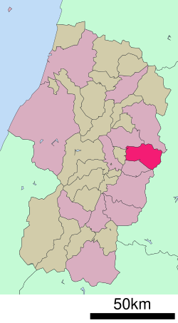 Location of Higashine in Yamagata Prefecture | |
 Higashine | |
| Coordinates: 38°25′52.7″N 140°23′27.9″E | |
| Country | Japan |
| Region | Tōhoku |
| Prefecture | Yamagata |
| Area | |
| • Total | 207.17 km2 (79.99 sq mi) |
| Population (February 2020) | |
| • Total | 47,910 |
| • Density | 230/km2 (600/sq mi) |
| Time zone | UTC+9 (Japan Standard Time) |
| Phone number | 0237-42-1111 |
| Address | 1-1-1 Chūō, Higashine-shi, Yamagata-ken 999-3795 |
| Climate | Cfa/Dfa |
| Website | Official website |
| Symbols | |
| Flower | Cherry |
| Tree | Japanese Zelkova |
Geography
Located on the eastern shore of the Mogami River in the northern part of the Yamagata Basin, the urban area of Higashine is located in an alluvial fan created by the Shirasui River, the Murayamano River, and the Nitto River flowing from the Ōu Mountains in the eastern part of the city. The western portion of the city is hilly, rising to the Ōu Mountains which form its eastern border.
Neighboring municipalities
Climate
Higashine has a Humid continental climate (Köppen climate classification Cfa) with large seasonal temperature differences, with warm to hot (and often humid) summers and cold (sometimes severely cold) winters. Precipitation is significant throughout the year, but is heaviest from August to October. The average annual temperature in Higashine is 11.4 °C (52.5 °F). The average annual rainfall is 1,088.2 mm (42.84 in) with July as the wettest month. The temperatures are highest on average in August, at around 24.7 °C (76.5 °F), and lowest in January, at around −1.1 °C (30.0 °F).[2]
| Climate data for Higashine (2003−2020 normals, extremes 2003−present) | |||||||||||||
|---|---|---|---|---|---|---|---|---|---|---|---|---|---|
| Month | Jan | Feb | Mar | Apr | May | Jun | Jul | Aug | Sep | Oct | Nov | Dec | Year |
| Record high °C (°F) | 11.9 (53.4) |
13.6 (56.5) |
22.3 (72.1) |
29.1 (84.4) |
33.5 (92.3) |
37.0 (98.6) |
37.0 (98.6) |
36.8 (98.2) |
36.7 (98.1) |
30.3 (86.5) |
23.7 (74.7) |
18.0 (64.4) |
37.0 (98.6) |
| Average high °C (°F) | 2.3 (36.1) |
3.5 (38.3) |
8.3 (46.9) |
15.7 (60.3) |
22.3 (72.1) |
26.0 (78.8) |
28.4 (83.1) |
30.2 (86.4) |
26.0 (78.8) |
19.3 (66.7) |
12.3 (54.1) |
5.4 (41.7) |
16.6 (61.9) |
| Daily mean °C (°F) | −1.1 (30.0) |
−0.5 (31.1) |
3.1 (37.6) |
9.0 (48.2) |
15.5 (59.9) |
20.0 (68.0) |
23.3 (73.9) |
24.7 (76.5) |
20.5 (68.9) |
13.4 (56.1) |
7.0 (44.6) |
1.6 (34.9) |
11.4 (52.5) |
| Average low °C (°F) | −5.3 (22.5) |
−5.0 (23.0) |
−2.1 (28.2) |
2.5 (36.5) |
8.7 (47.7) |
14.4 (57.9) |
19.2 (66.6) |
20.2 (68.4) |
15.7 (60.3) |
7.9 (46.2) |
2.1 (35.8) |
−2.3 (27.9) |
6.3 (43.4) |
| Record low °C (°F) | −15.0 (5.0) |
−14.2 (6.4) |
−10.7 (12.7) |
−5.7 (21.7) |
−0.2 (31.6) |
4.9 (40.8) |
10.1 (50.2) |
11.5 (52.7) |
4.9 (40.8) |
−0.7 (30.7) |
−5.8 (21.6) |
−12.2 (10.0) |
−15.0 (5.0) |
| Average precipitation mm (inches) | 90.4 (3.56) |
53.1 (2.09) |
61.6 (2.43) |
59.7 (2.35) |
63.4 (2.50) |
86.1 (3.39) |
162.3 (6.39) |
123.1 (4.85) |
100.3 (3.95) |
96.0 (3.78) |
80.8 (3.18) |
111.3 (4.38) |
1,088.2 (42.84) |
| Average precipitation days (≥ 1.0 mm) | 16.6 | 12.8 | 12.2 | 9.7 | 8.5 | 8.5 | 13.2 | 10.4 | 9.7 | 10.5 | 13.7 | 17.3 | 143.1 |
| Source: Japan Meteorological Agency[3][2] | |||||||||||||
Demographics
Per Japanese census data,[4] the population of Higashine has grown steadily over the past 50 years.
| Year | Pop. | ±% |
|---|---|---|
| 1920 | 25,059 | — |
| 1930 | 28,626 | +14.2% |
| 1940 | 30,257 | +5.7% |
| 1950 | 42,767 | +41.3% |
| 1960 | 40,917 | −4.3% |
| 1970 | 39,113 | −4.4% |
| 1980 | 40,559 | +3.7% |
| 1990 | 42,751 | +5.4% |
| 2000 | 44,800 | +4.8% |
| 2010 | 46,414 | +3.6% |
| 2020 | 47,682 | +2.7% |
History
The area of present-day Higashine was part of ancient Dewa Province and is mentioned in the Engishiki records of the early Heian period. Under the Edo period Tokugawa shogunate, much of the area was part of the holdings of the Ezo-based Matsumae Domain. After the start of the Meiji period, the area became part of Kitamurayama District, Yamagata Prefecture. The village of Higashine was established on April 1, 1889 with the establishment of the modern municipalities system and was raised to town status on June 15, 1896. It attained city status on November 3, 1958.
Government
Higashine has a mayor-council form of government with a directly elected mayor and a unicameral city legislature of 18 members. The city contributes two members to the Yamagata Prefectural Assembly. In terms of national politics, the city is part of Yamagata District 2 of the lower house of the Diet of Japan.
Economy
Higashine is known as "The Fruit Kingdom" and is especially well known for its cherries as well as for apples, pears and persimmons. The city mascot is a pear with cherry earrings and a staff with an apple. Higashine is the largest producer of cherries in Yamagata Prefecture, which is the third largest producer of cherries in Japan.[citation needed]
Higashine also has a large industrial park. Some of the businesses include 3M, Casio, THK, ODELIC, and Kyocera. Many of these businesses are involved in manufacturing and research and development.
Education
Higashine has nine public elementary schools and five public middle schools operated by the city government and one public high schools operated by the Yamagata Prefectural Board of Education. The prefecture also operates one special education school for the handicapped.
Transportation
Airports
Railway
![]() East Japan Railway Company - Yamagata Shinkansen
East Japan Railway Company - Yamagata Shinkansen
- Sakuranbo Higashine
![]() East Japan Railway Company - Ōu Main Line
East Japan Railway Company - Ōu Main Line
- Jinmachi - Sakuranbo Higashine - Higashine
Highway
 Tōhoku-Chūō Expressway – Higashine Interchange
 National Route 13
 National Route 48
 National Route 287
Military
The 6th Division (第6師団) is one of nine active divisions of the Japan Ground Self-Defense Force is headquartered in at JGSDF Camp Jinmachi in Higashine. Its responsibility is the defense of Fukushima, Miyagi, and Yamagata prefectures.
Noted people from Higashine
- Kazushige Abe, Akutagawa Prize winning novelist
- Masatoshi Abe, politician
- Tomoaki Honma, professional wrestler
References
- Higashine City official statistics (in Japanese)
- 気象庁 / 平年値(年・月ごとの値). JMA. Retrieved March 25, 2022.
- 観測史上1~10位の値(年間を通じての値). JMA. Retrieved March 25, 2022.
- Higashine population statistics
External links
![]() Media related to Higashine, Yamagata at Wikimedia Commons
Media related to Higashine, Yamagata at Wikimedia Commons
- Official Website (in Japanese)
- Yamagata Tourism (in Japanese)
Yamagata (capital) | ||
| Core city | ||
| Cities | ||
| Districts |
| |
List of mergers in Yamagata Prefecture | ||
Authority control | |
|---|---|
| General | |
| National libraries | |
| Other |
|
На других языках
[de] Higashine
Higashine (jap. .mw-parser-output .Hani{font-size:110%}東根市, -shi) ist eine Stadt in der Präfektur Yamagata in Japan.- [en] Higashine
[ru] Хигасине
Хигасине (яп. 東根市 Хигасинэ-си) — город в Японии, находящийся в префектуре Ямагата. Площадь города составляет 207,17 км²[1], население — 47 328 человек (1 августа 2014)[2], плотность населения — 228,45 чел./км².Другой контент может иметь иную лицензию. Перед использованием материалов сайта WikiSort.org внимательно изучите правила лицензирования конкретных элементов наполнения сайта.
WikiSort.org - проект по пересортировке и дополнению контента Википедии