world.wikisort.org - Japan
Kawanishi (川西町, Kawanishi-machi, IPA: [kawa̠ɲiɕiꜜmatɕi]) is a town located in Yamagata Prefecture, Japan. As of 1 January 2020[update], the town had an estimated population of 14,967 in 5052 households,[1] and a population density of 90 persons per km². The total area of the town is 166.46 square kilometres (64 sq mi).
Kawanishi
川西町 | |
|---|---|
Town | |
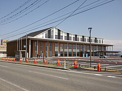
 Kawanishi Town Hall | |
 Location of Kawanishi in Yamagata Prefecture | |
 Kawanishi | |
| Coordinates: 38°00′16.2″N 140°02′44.9″E | |
| Country | Japan |
| Region | Tōhoku |
| Prefecture | Yamagata |
| District | Higashiokitama |
| Area | |
| • Total | 166.46 km2 (64.27 sq mi) |
| Population (February 2020) | |
| • Total | 14,967 |
| • Density | 90/km2 (230/sq mi) |
| Time zone | UTC+9 (Japan Standard Time) |
| - Tree | Pine |
| - Flower | Dahlia |
| Phone number | 0238-42-2111 |
| Address | 1567 Kamikomatsu, Kawanishi-machi, Higashiokitama-gun, Yamagata-ken 999-0193 |
| Website | Official website |

Geography
Kawanishi is located in the southwest of the Yonezawa Basin. There are two major rivers, the Mogami River and the Omonogawa River, running along the town's borders. The literal meaning of Kawanishi is "west of the river", which refers to its location west of the Mogami River. Also, there are two minor rivers, the Inukawa and the Kurokawa, running through the town.
Neighboring municipalities
Climate
Kawanishi has a Humid continental climate (Köppen climate classification Cfa) with large seasonal temperature differences, with warm to hot (and often humid) summers and cold (sometimes severely cold) winters. Precipitation is significant throughout the year, but is heaviest from August to October. The average annual temperature in Kawanishi is 11.2 °C. The average annual rainfall is 1555 mm with September as the wettest month. The temperatures are highest on average in August, at around 25.0 °C, and lowest in January, at around -1.5 °C.[2]
Demographics
Per Japanese census data,[3] the population of Kawanishi peaked around the year 1950 and has declined steadily since then. It is now considerably less than it was a hundred years ago.
| Year | Pop. | ±% |
|---|---|---|
| 1920 | 23,608 | — |
| 1930 | 25,581 | +8.4% |
| 1940 | 26,498 | +3.6% |
| 1950 | 30,645 | +15.7% |
| 1960 | 28,506 | −7.0% |
| 1970 | 23,769 | −16.6% |
| 1980 | 22,423 | −5.7% |
| 1990 | 21,548 | −3.9% |
| 2000 | 19,688 | −8.6% |
| 2010 | 17,313 | −12.1% |
| 2020 | 14,558 | −15.9% |
History
The area of present-day Kawanishi was part of ancient Dewa Province. After the start of the Meiji period, the area became part of Higashiokitama District, Yamagata Prefecture. The nineteenth-century English traveler, Isabella Bird, stayed in the town, and noted the Yonezawa Basin area "as a 'Garden of Eden,' ground that smiles fruitfully, and Arcadia in Asia."[4] The town of Kawanishi was established on January 1, 1955 by the merger of the villages of Otsuka, Inukawa, Komatsu and Chugun from Meiji period, the area became part of Higashiokitama District and the village of Tamaniwa from Minamiokitama District. The village of Yoshijima from Higashiokitama District joined the town on February 1, 1955.
Economy
The abundance of water makes the town ideal for farming, mostly rice. The town also produces the famous Yonezawa beef since the Meiji era.
Education
Kawanishi has six public elementary schools and one public middle school operated by the town government, and one public high school operated by the Yamagata Prefectural Board of Education.
Transportation
Railway
![]() East Japan Railway Company - Yonesaka Line
East Japan Railway Company - Yonesaka Line
![]() Yamagata Railway - Flower Nagai Line
Yamagata Railway - Flower Nagai Line
Highway
 National Route 113
 National Route 287
Local attractions
- Kawanishi Dahlia Park
Noted People from Kawanishi
- Hisashi Inoue, playwright and writer of comic fiction.
Film Locations
- Warabi no kō (2003)
- Swing Girls (2004)- The competition scene filmed particularly at the town's library and Theater complex called Kawanishi-machi Friendly Plaza.
References
- Kawanishi Town official statistics (in Japanese)
- Kawanishi climate data
- Kawanishi population statistics
- "Nature - YOKOSO! JAPAN TOHOKU". www.tohokukanko.jp. Archived from the original on 2009-06-30.
External links
![]() Media related to Kawanishi, Yamagata at Wikimedia Commons
Media related to Kawanishi, Yamagata at Wikimedia Commons
- Official Website (in Japanese)
- Official Kawanishi Tourism website (in Japanese)
На других языках
- [en] Kawanishi, Yamagata
[es] Kawanishi (Yamagata)
Kawanishi (川西町, Kawanishi-machi?) es un pueblo localizado en la prefectura de Yamagata, Japón. En junio de 2019 tenía una población de 14.854 habitantes y una densidad de población de 89,2 personas por km². Su área total es de 166,60 km².[ru] Каваниси (Ямагата)
Каваниси (яп. 川西町 Каваниси-мати) — посёлок в Японии, находящийся в уезде Хигасиокитама префектуры Ямагата. Площадь посёлка составляет 166,46 км²[1], население — 16 198 человек (1 августа 2014)[2], плотность населения — 97,31 чел./км².Другой контент может иметь иную лицензию. Перед использованием материалов сайта WikiSort.org внимательно изучите правила лицензирования конкретных элементов наполнения сайта.
WikiSort.org - проект по пересортировке и дополнению контента Википедии

