world.wikisort.org - Japan
Shimane Prefecture (島根県, Shimane-ken) is a prefecture of Japan located in the Chūgoku region of Honshu.[1] Shimane Prefecture is the second-least populous prefecture of Japan at 665,205 (February 1, 2021) and has a geographic area of 6,708.26 km2. Shimane Prefecture borders Yamaguchi Prefecture to the southwest, Hiroshima Prefecture to the south, and Tottori Prefecture to the east.
Shimane Prefecture
島根県 | |
|---|---|
Prefecture | |
| Japanese transcription(s) | |
| • Japanese | 島根県 |
| • Rōmaji | Shimane-ken |
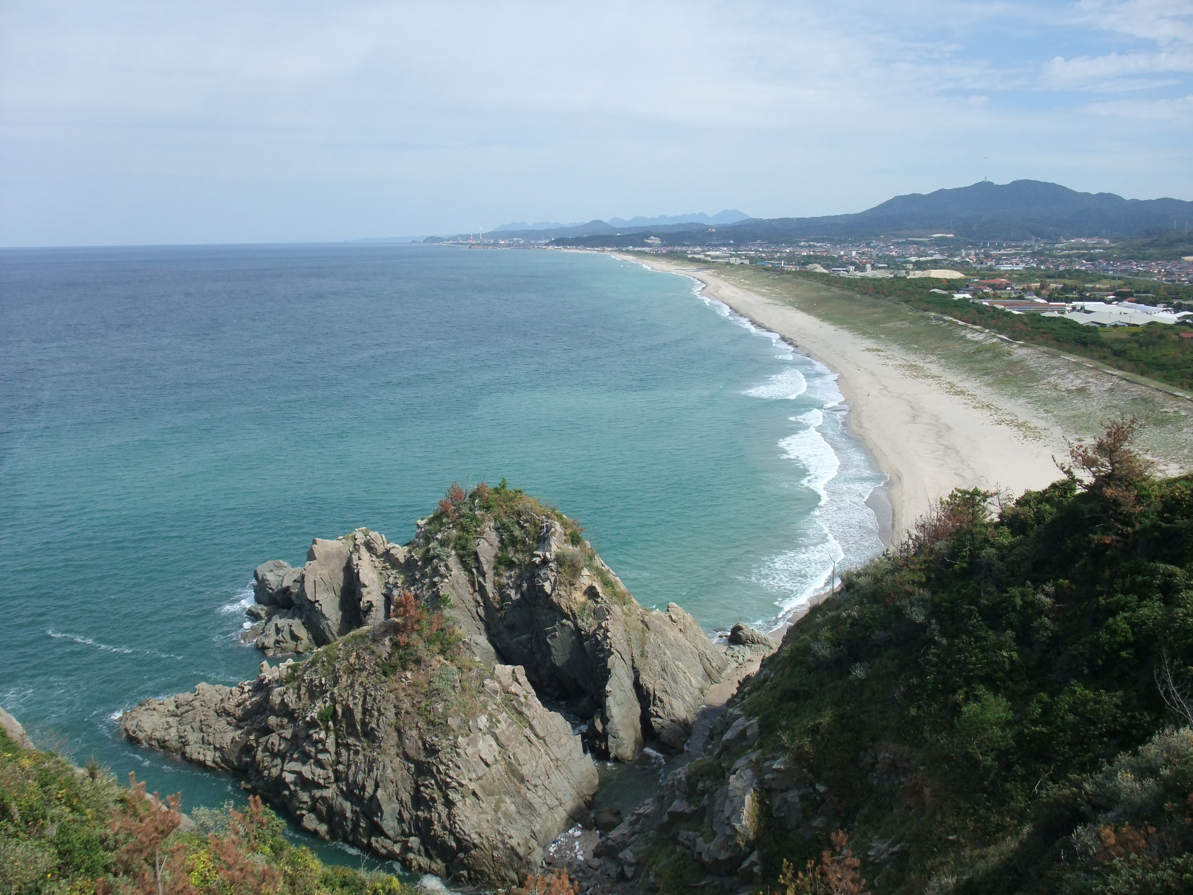 The coast of Gōtsu City, Shimane Prefecture seen from the Osakihana lighthouse | |
|
Flag Symbol | |
| Anthem: Usu-murasaki no yamanami | |
| Country | Japan |
| Region | Chūgoku (San'in) |
| Island | Honshu |
| Capital | Matsue |
| Subdivisions | Districts: 5, Municipalities: 19 |
| Government | |
| • Governor | Tatsuya Maruyama |
| Area | |
| • Total | 6,708.26 km2 (2,590.07 sq mi) |
| • Rank | 19th |
| Population (February 1, 2021) | |
| • Total | 665,205 |
| • Rank | 46th |
| • Density | 99/km2 (260/sq mi) |
| ISO 3166 code | JP-32 |
| Website | www1 |
| Symbols | |
| Bird | Whooper swan (Cygnus cygnus) |
| Fish | Flying Fish |
| Flower | Moutan peony (Paeonia suffruticosa) |
| Tree | Japanese black pine (Pinus thunbergii) |
Matsue is the capital and largest city of Shimane Prefecture, with other major cities including Izumo, Hamada, and Masuda.[2] Shimane Prefecture contains the majority of the Lake Shinji-Nakaumi metropolitan area centered on Matsue, and with a population of approximately 600,000 is Japan's third-largest metropolitan area on the Sea of Japan coast after Niigata and Greater Kanazawa. Shimane Prefecture is bounded by the Sea of Japan coastline on the north, where two-thirds of the population live, and the Chūgoku Mountains on the south. Shimane Prefecture governs the Oki Islands in the Sea of Japan which juridically includes the disputed Liancourt Rocks (竹島, Takeshima). Shimane Prefecture is home to Izumo-taisha, one of the oldest Shinto shrines in Japan, and the Tokugawa-era Matsue Castle.
History

Early history
The history of Shimane starts with Japanese mythology. The Shinto god Ōkuninushi was believed to live in Izumo, an old province in Shimane. Izumo Shrine, which is in the city of Izumo, honors the god.[3] At that time, the current Shimane prefecture was divided into three parts: Iwami, Izumo, and Oki.[4] That lasted until the abolition of the han system took place in 1871. During the Nara period, Kakinomoto no Hitomaro read a poem on Shimane's nature when he was sent as the Royal governor.[5]
Later on in the Kamakura period, Kamakura shogunate forced emperors Go-Toba and Godaigo into exile in Oki. Emperor Go-Daigo later escaped away from Oki and began rallying supporters against the shogunate, which succeeded.[6]
Middle Ages
During the Muromachi period, Izumo and Oki were controlled by the Kyogoku clan. However, after the Ōnin War, the Amago clan expanded power based in Gassantoda Castle and the Masuda clan dominated Iwami Province. The Iwami Ginzan Silver Mine was located between Amago territory and Masuda territory, so there were many battles between these clans for the silver. However, in 1566 Mōri Motonari conquered Izumo, Iwami, and Oki.[6] After over 30 years of Mori control, in 1600 Horio Yoshiharu entered Izumo and Oki as the result of Battle of Sekigahara, which Mori lost. Following the change, Horio Yoshiharu decided to move to build Matsue Castle instead of Gassan-Toda, and soon after Yoshiharu's death the castle was completed. Later in 1638, the grandson of Tokugawa Ieyasu, Matsudaira Naomasa became the ruler because the Horio clan had no heir, and his family ruled until the abolition of the han system.
The Iwami area was split into three regions: the mining district, under the direct control of the Shogunate, the Hamada clan region, and the Tsuwano clan region. The Iwami Ginzan, now a UNESCO World Heritage Site produced silver and was one of the nation's largest silver mine by the early 17th century. The Hamada clan was on the shogunate's side in the Meiji Restoration, and the castle was burned down. The Tsuwano clan, despite then being ruled by the Matsudaira, was on the emperor's side in the restoration.[7]
Modern Age
In 1871, the abolition of the han system placed the old Shimane and Hamada Provinces in the current area of Shimane Prefecture. Later that year, Oki became part of Tottori. In 1876, Hamada Prefecture was merged into the Shimane Prefecture. Also, Tottori Prefecture was added in the same year. However, five years later, in 1881, the current portion of Tottori Prefecture was separated and the current border was formed.[7]
Geography
Shimane Prefecture is situated on the Sea of Japan side of the Chūgoku region. Because of its mountainous landscape, rice farming is done mostly in the Izumo plain where the city of Izumo is located.[8] Another major landform is the Shimane peninsula. The peninsula is located across the Sea of Japan from Izumo to Sakaiminato, which is located in Tottori prefecture. Also, the peninsula created two brackish lakes, Lake Shinji and Nakaumi. The island of Daikon is located in Nakaumi. Off the main island of Honshū, the island of Oki belongs to Shimane prefecture as well. The island itself is in the Daisen-Oki National Park.[8] Shimane also claims the use of Liancourt Rocks, over which they are in dispute with South Korea.[9]
As of 1 April 2012, 6% of the total land area of the prefecture was designated as Natural Parks, namely Daisen-Oki National Park; Hiba-Dōgo-Taishaku and Nishi-Chūgoku Sanchi Quasi-National Parks; and eleven Prefectural Natural Parks.[10]
Most major cities are located either on the seaside, or along a river.[8]
Cities

City Town Village


Eight cities are located in Shimane Prefecture, the largest in population being Matsue, the capital, and the smallest being Gōtsu. The cities Masuda, Unnan, Yasugi, and Gōtsu had a slight population increase due to the mergers in the early 2000s.[11]
| Name | Area (km2) | Population | Map | |
|---|---|---|---|---|
| Rōmaji | Kanji | |||
| 江津市 | 268.51 | 24,009 | ||
| 浜田市 | 689.6 | 57,142 | ||
| 出雲市 | 624.36 | 172,039 | ||
| 益田市 | 733.16 | 46,892 | ||
| 松江市 | 572.99 | 202,008 | ||
| 大田市 | 436.11 | 34,354 | ||
| 雲南市 | 553.4 | 38,281 | ||
| 安来市 | 420.97 | 38,875 | ||
Towns and villages
These are the towns and villages of each district. The number of towns and villages greatly decreased during the mergers. However, they hold about one-third of the prefecture's population.[11]
| Name | Area (km2) | Population | District | Type | Map | |
|---|---|---|---|---|---|---|
| Rōmaji | Kanji | |||||
| 海士町 | 33.5 | 2,293 | Oki District | Town | ||
| 知夫村 | 13.7 | 657 | Oki District | Village | ||
| 飯南町 | 242.84 | 4,908 | Iishi District | Town | ||
| 川本町 | 106.39 | 3,331 | Ōchi District | Town | ||
| 美郷町 | 282.92 | 4,712 | Ōchi District | Town | ||
| 西ノ島町 | 55.98 | 2,923 | Oki District | Town | ||
| 隠岐の島町 | 242.97 | 14,422 | Oki District | Town | ||
| 奥出雲町 | 368.06 | 12,655 | Nita District | Town | ||
| 邑南町 | 419.29 | 10,922 | Ōchi District | Town | ||
| 津和野町 | 307.09 | 7,478 | Kanoashi District | Town | ||
| 吉賀町 | 336.29 | 6,231 | Kanoashi District | Town | ||
Mergers
| April 1976 | January 2011 | January 2012 | ||
|---|---|---|---|---|
| Izumo Region | Matsue City (Old System) | Matsue City (New System) | Matsue City (August 1, 2011 Merger with Higashiizumo Town) | |
| Yatsuka District | Kashima Town | |||
| Shimane Town | ||||
| Mihonoseki Town | ||||
| Yakumo Village | ||||
| Tamayu Town | ||||
| Shinji Town | ||||
| Yatsuka Town | ||||
| Higashiizumo Town | ||||
| Yasugi City (Old System) | Yasugi City (New System) | Yasugi City | ||
| Nogi District | Hirose Town | |||
| Hakuta Town | ||||
| Nita District | Yokota Town | Okuizumo Town | ||
| Nita Town | ||||
| Izumo City (Old System) | Izumo City (New System) | Izumo City (October 1, 2011 Merger with Hikawa Town) | ||
| Hirata City | ||||
| Hikawa District | Taisha Town | |||
| Koryo Town | ||||
| Taki Town | ||||
| Sada Town | ||||
| Hikawa Town | ||||
| Ōhara District | Daitō Town | Unnan City | ||
| Kamo Town | ||||
| Kisuki Town | ||||
| Iishi District | Mitoya Town | |||
| Kakeya Town | ||||
| Yoshida Village | ||||
| Tonbara Town | Iinan Town | |||
| Akagi Town | ||||
| Iwami Region | Ōda City (Old System) | Ōda City (New System) | Ōda City | |
| Nima District | Yunotsu Town | |||
| Nima Town | ||||
| Gōtsu City (Old System) | Gōtsu City (New System) | Gōtsu City | ||
| Ōchi District | Sakurae Town | |||
| Ōchi Town | Misato Town | |||
| Daiwa Village | ||||
| Iwami Town | Ōnan Town | |||
| Mizuho Town | ||||
| Hasumi Village | ||||
| Kawamoto Town | ||||
| Hamada City (Old System) | Hamada City (New System) | Hamada City | ||
| Naka District | Asahi Town | |||
| Kanagi Town | ||||
| Misumi Town | ||||
| Yasaka Village | ||||
| Masuda City (Old System) | Masuda City (New System) | Masuda City | ||
| Mino District | Mito Town | |||
| Hikimi Town | ||||
| Kanoashi District | Tsuwano Town (Old System) | Tsuwano Town (New System) | Tsuwano Town | |
| Nichihara Town | ||||
| Muikaichi Town | Yoshika Town | |||
| Kakinoki Village | ||||
| Oki Region | Oki District | Saigō Town | Okinoshima Town | |
| Fuse Village | ||||
| Goka Village | ||||
| Tsuma Village | ||||
| Nishinoshima Town | ||||
| Ama Town | ||||
| Chibu Village | ||||
Climate
The prefecture has a sub-tropical climate. Winter is cloudy with a little snow, and summer is humid. The average annual temperature is 14.6 °C (58.3 °F). It rains almost every day in the rainy season, from June to mid-July. The highest average monthly temperature occurs in August with 26.3 °C (79.3 °F). The average annual precipitation is 1,799 millimetres (70.8 in), higher than Tokyo's 1,467 mm (57.8 in) and Obihiro with 920 mm (36.2 in).[11]
| Average Year (Month) |
Oki | Izumo (Coastal) | Izumo (Inland) | ||||||||
|---|---|---|---|---|---|---|---|---|---|---|---|
| Okinoshima Saigo | Okinoshima Saigo Cape | Ama | Matsue Kashima | Matsue | Hikawa | Izumo | Okuizumo Yokota | Unnan Kakeya | Iinan Akana | ||
| Average Temperature (℃) |
Warmest Month | 25.6 (Aug) | 25.8 (Aug) | 25.6 (Aug) |
26.3 (Aug) | 25.8 (Aug) | 24.0 (Aug) |
24.5 (Aug) | 23.4 (Aug) | ||
| Coldest Month | 3.9 (Feb) | 4.5 (Feb) | 4.4 (Feb) |
4.2 (Jan) | 4.5 (Feb) | 0.7 (Feb) |
2.3 (Feb) | 0.4 (Jan, Feb) | |||
| Rainfall (mm) |
Heaviest Month | 211.6 (Sept) | 227.0 (July) | 218.0 (Sept) |
240.5 (July) | 236.2 (July) | 234.2 (July) |
257.1 (July) | 282.2 (July) | ||
| Driest Month | 110.4 (Oct) | 96.4 (Feb) | 104.7 (April) |
114.5 (April) | 96.3 (Feb) | 103.4 (April) |
120.7 (April) | 116.5 (Oct) | |||
| Average Year (Month) |
Iwami (Coastal) | Iwami (Inland) | |||||||||
| Ōda | Hamada | Masuda | Masuda City Takatsu | Kawamoto | Ōnan | Hamada City Yasaka | Tsuwano | Yoshika | Yoshika Muikaichi | ||
| Average Temperature (℃) |
Warmest Month | 26.5 (Aug) | 26.2 (Aug) |
26.8 (Aug) | 24.2 (Aug) | 23.9 (Aug) |
23.6 (Aug) | 25.7 (Aug) |
24.5 (Aug) | ||
| Coldest Month | 4.9 (Jan, Feb) | 5.8 (Feb) |
5.4 (Jan, Feb) | 2.7 (Jan) | 0.8 (Jan) |
1.5 (Jan) | 3.0 (Jan) |
1.9 (Jan) | |||
| Rainfall (mm) |
Heaviest Month | 246.3 (July) | 257.7 (July) |
223.9 (June) | 260.2 (July) | 260.6 (July) |
340.0 (July) | 285.6 (July) |
337.4 (June) | ||
| Driest Month | 98.3 (Feb) | 90.9 (Feb) |
87.9 (Feb) | 112.5 (Feb) | 109.2 (Nov) |
130.4 (April) | 99.7 (Dec) |
76.8 (Dec) | |||
Transportation
Airports
Three airports serve Shimane. The Izumo Airport located in Izumo is the largest airport in the prefecture in terms of passengers, which has regular flights to Haneda Airport, Osaka Airport, Fukuoka Airport, and Oki Airport. The Iwami Airport has two flights each day to Haneda and Osaka and 2 arrivals. Oki Airport has scheduled flights to Osaka and Izumo Airports.[12]
Rail
JR West and Ichibata Electric Railway serves the prefecture in terms of rail transportation. The Sanin Main Line goes through the prefecture on the Sea of Japan side going into major cities such as Matsue and Izumo.[13] Izumoshi and Matsue stations are the major stops in the prefecture. The Kisuki line, which forks from Shinji Station on the Sanin Line, connects with the Geibi Line in Hiroshima Prefecture, cutting into the Chūgoku Mountains.[13] Ichibata Electric Railway serve the Shimane peninsula from Dentetsu-Izumoshi Station and Izumo Taisha-mae Station to Matsue Shinjiko-Onsen Station.[14]
JR West has three Limited Express trains to Shimane, which are Super Matsukaze, Super Oki, and Yakumo.[15] Additionally, the overnight limited express Sunrise Izumo operates daily between Tokyo and Izumoshi.
- West Japan Railway Company
- Sanin Main Line
- Sankō Line
- Kisuki Line
- Yamaguchi Line
- Ichibata Electric Railway
- Kita-Matsue Line
- Taisha Line
Roads
General Roads
- Japan National Route 9
- Izumo Bypass
- Gōtsu Road
- Japan National Route 54
- Japan National Route 180
- Japan National Route 184
- Japan National Route 186
- Japan National Route 187
- Japan National Route 191
- Japan National Route 261
- Japan National Route 314
- Japan National Route 375
- Japan National Route 431
- Japan National Route 432
- Japan National Route 485
- Japan National Route 488
Highways
The four expressways in the prefecture connect major cities with other prefectures. The Matsue expressway connects Matsue with Unnan and Yonago in Tottori prefecture. Hamada Expressway forks from the Chūgoku Expressway at Kita-Hiroshima and stretches to Hamada.[8]
- Sanin Expressway
- Matsue Expressway
- Hamada Expressway
- Chūgoku Expressway
Ferry/High Speed Boats
- Oki Kisen
 JR Izumo Station
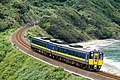 Super Oki Express in Sanin Line
 Ichibata Electric Railway
 Oki Saigo Port


Economy
In Shimane, the largest employer is the retail industry, employing over 60,000 workers. The supermarket, Mishimaya, and the hardware store, Juntendo, are examples of companies based in Shimane. The manufacturing industry has the second number of employees with 49,000 workers. [citation needed]
Companies based in Shimane
Manufacturing
- Izumo Murata Manufacturing
- Shimane Fujitsu
- Mitsubishi Agricultural Machinery
Financial
- The Shimane Bank
- The San-in Godo Bank
Others
- Network Applied Communication Laboratory
- Mishimaya
- Juntendo
- Ichibata Electric Railway
Major factories
- Hitachi Metals
Demographics
One-third of the prefecture's population is concentrated in the Izumo-Matsue area. Otherwise, over two-thirds of the population is on the coastline. The reason is that the Chūgoku Mountains make the land inland harder to inhabit. The capital, Matsue, has the smallest population out of all the 47 prefectural capitals. Shimane has also the largest percentage of the elderly.[11] The province had an estimated 743 centenarians per million inhabitants in September 2010, the highest ratio in Japan, overtaking Okinawa Prefecture (667 centenarians per million).[16]
Population by age
Total Population in age groups
2007 Estimated Population
Unit: Thousands
| Age | Population |
|---|---|
| 0 - 4 | |
| 5 - 9 | |
| 10 - 14 | |
| 15 - 19 | |
| 20 - 24 | |
| 25 - 29 | |
| 30 - 34 | |
| 35 - 39 | |
| 40 - 44 | |
| 45 - 49 | |
| 50 - 54 | |
| 55 - 59 | |
| 60 - 64 | |
| 65 - 69 | |
| 70 - 74 | |
| 75 - 79 | |
| 80 and over |
Population in age groups by gender
2007 Estimated population
Unit: Thousands
| Male | Age | Female |
|---|---|---|
| 15 |
0 - 4 | |
| 17 |
5 - 9 | |
| 18 |
10 - 14 | |
| 19 |
15 - 19 | |
| 16 |
20 - 24 | |
| 19 |
25 - 29 | |
| 22 |
30 - 34 | |
| 20 |
35 - 39 | |
| 19 |
40 - 44 | |
| 22 |
45 - 49 | |
| 26 |
50 - 54 | |
| 34 |
55 - 59 | |
| 22 |
60 - 64 | |
| 20 |
65 - 69 | |
| 22 |
70 - 74 | |
| 19 |
75 - 79 | |
| 20 |
80 and over |
- Source:Graph 10/Prefectures Age(In Age groups), Gender divided population-Total Population
(Ministry of Internal Affairs Statistics Bureau)
 | ||||||||||||||||||||||||||||
| Comparison of Population Distribution between Shimane and Japanese National Average | Population Distribution by Age and Sex in Shimane | |||||||||||||||||||||||||||
■Shimane ■Japan (average) |
■Male ■Female | |||||||||||||||||||||||||||
| ||||||||||||||||||||||||||||
| 2015 Census, Ministry of Internal Affairs and Communications - Statistics Department | ||||||||||||||||||||||||||||
| Year | Pop. | ±% |
|---|---|---|
| 1920 | 715,000 | — |
| 1930 | 740,000 | +3.5% |
| 1940 | 741,000 | +0.1% |
| 1950 | 913,000 | +23.2% |
| 1960 | 889,000 | −2.6% |
| 1970 | 773,575 | −13.0% |
| 1980 | 784,795 | +1.5% |
| 1990 | 781,021 | −0.5% |
| 2000 | 761,503 | −2.5% |
| 2010 | 717,397 | −5.8% |
| 2020 | 679,626 | −5.3% |
| [17][18] | ||
Culture
Cultural Assets

- World Cultural Heritage
- The Historic Remains of Iwami Ginzan Silver Mine and its Cultural Background (Ōda City)
- National Treasures
- Izumo-taisha Main Shrine (Izumo City)
- Kamosu Shrine Main Shrine (Matsue City)
- Toiletry case with autumn field and deer design (Izumo-taisha)
- Armour Laced with white thread (Hinomisaki Shrine)
- Bronze bells from the Kamo-Iwakura site Unearthed bronze bell-shaped vessel (Unnan City)
- Kojindani Ruins Unearthed ruins (Izumo City)
- Important Traditional Building Preservation Area
- Ōmori (Ōda City)
- Yunotsu (Ōda City)
Languages (Dialects)
- Unpaku dialect (Izumo dialect, Oki dialect, etc.)
- Iwami dialect
Universities in Shimane Prefecture
- Shimane University, Matsue and Izumo (National university)[19]
- The University of Shimane, Hamada (Prefectural university)[20]
Tourism
- Shimane Vogel Park
- Matsue Castle
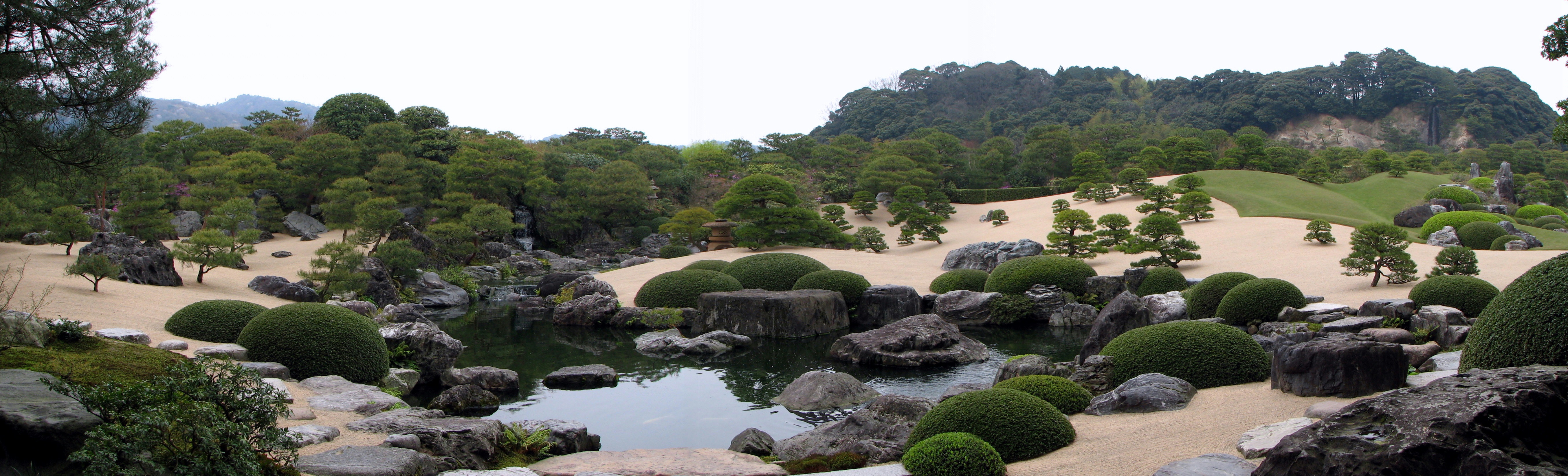
- Adachi Museum of Art
- Aquas Aquarium
- Iwami Ginzan Silver Mine
- Izumo-taisha
- Izumo Province
- Shimane Art Museum
- Iwami Art Museum
- Mt. Sanbe
- Tamatsukuri Onsen
Prefectural symbols
The prefectural flower is the mountain peony. On the island of Daikonjima, they were grown from at least the 18th century.[21]
See also
Notes
- Nussbaum, Louis-Frédéric. (2005). "Shimane Province" in Japan Encyclopedia, p. 859, p. 859, at Google Books; "Chūgoku" at p. 127, p. 127, at Google Books
- Nussbaum, "Matsue" at p. 617, p. 617, at Google Books
- "Izumo Shrine website". Archived from the original on August 23, 2007. Retrieved August 22, 2007.
- Nussbaum, "Provinces and prefectures" at p. 780, p. 780, at Google Books
- Shimane Prefecture introduction Archived March 3, 1997, at the Wayback Machine
- 古川清行 Furukawa Kiyoyuki (2003). スーパー日本史 Super Nihon-shi. 講談社 Kōdansha. ISBN 4-06-204594-X.
- History of Shimane Prefecture Archived November 18, 2007, at the Wayback Machine
- 新編 中学校社会科地図 Updated Social studies map for Junior High school. 帝国書院 Teikoku Shoin. 2007. ISBN 978-4-8071-4091-6.
- Liancourt Rocks
- "General overview of area figures for Natural Parks by prefecture" (PDF). Ministry of the Environment. April 1, 2012. Retrieved August 10, 2014.
- 考える社会科地図 Kangaeru Shakaika Chizu. 四谷大塚出版 Yotsuya-Ōtsuka Shuppan. 2005. p. 113.
- Flight schedule of Oki Airport Archived August 30, 2007, at the Wayback Machine
- Route map for JR West
- Route map of Ichibata Electric Railway
- JR West website on limited express trains
- Japan Times “Centenarians to Hit Record 44,000”. The Japan Times, Sept. 15, 2010. Okinawa Prefecture also had the largest loss of young and middle-aged population during the Pacific War.
- Shimane 1995-2020 population statistics
- Shimane 1920-2000 population statistics
- Shimane University
- University of Shimane
- Symbols of Shimane Prefecture: From Shimane Prefecture website Archived September 28, 2007, at the Wayback Machine
References
- Nussbaum, Louis-Frédéric and Käthe Roth. (2005). Japan encyclopedia. Cambridge: Harvard University Press. ISBN 978-0-674-01753-5; OCLC 58053128
External links
- Official homepage of Shimane Prefecture
- National Archives of Japan ... Shimane map (1891)[permanent dead link]
- Sightseeing In Shimane
Matsue (capital) | ||
| Core city |
| |
| Cities | ||
| Districts | ||
List of mergers in Shimane Prefecture | ||
Regions and administrative divisions of Japan | |||||||||||||||||
|---|---|---|---|---|---|---|---|---|---|---|---|---|---|---|---|---|---|
| |||||||||||||||||
| Regions |  | ||||||||||||||||
| 47 Prefectures |
| ||||||||||||||||
| |||||||||||||||||
Authority control | |
|---|---|
| General | |
| National libraries | |
| Other | |
На других языках
[de] Präfektur Shimane
Die Präfektur Shimane (jap. 島根県, Shimane-ken) ist eine der Präfekturen Japans. Sie liegt in der Region Chūgoku auf der Insel Honshū. Sitz der Präfekturverwaltung ist Matsue.- [en] Shimane Prefecture
[ru] Симане
Сима́не[1] (яп. 島根県 Симанэ-кэн) — префектура, расположенная в регионе Тюгоку на острове Хонсю, Япония. Площадь префектуры составляет 6707,96 км²[2], население — 697 398 человек (1 августа 2014)[3], плотность населения — 103,97 чел./км². В 2015 году население префектуры составляло 694 352 человека, площадь — 6708,24 км²[4]. Административный центр префектуры — город Мацуэ.Другой контент может иметь иную лицензию. Перед использованием материалов сайта WikiSort.org внимательно изучите правила лицензирования конкретных элементов наполнения сайта.
WikiSort.org - проект по пересортировке и дополнению контента Википедии