world.wikisort.org - Japan
Otaru (小樽市, Otaru-shi) is a city and port in Shiribeshi Subprefecture, Hokkaido, Japan, northwest of Sapporo. The city faces Ishikari Bay and the Sea of Japan, and has long served as the main port of the bay. With its many historical buildings, Otaru is a popular tourist destination. Because it is a 25-minute drive from Sapporo, it has recently[when?] grown as a bedroom community.
This article uses bare URLs, which are uninformative and vulnerable to link rot. (August 2022) |
Otaru
小樽市 | |
|---|---|
City | |
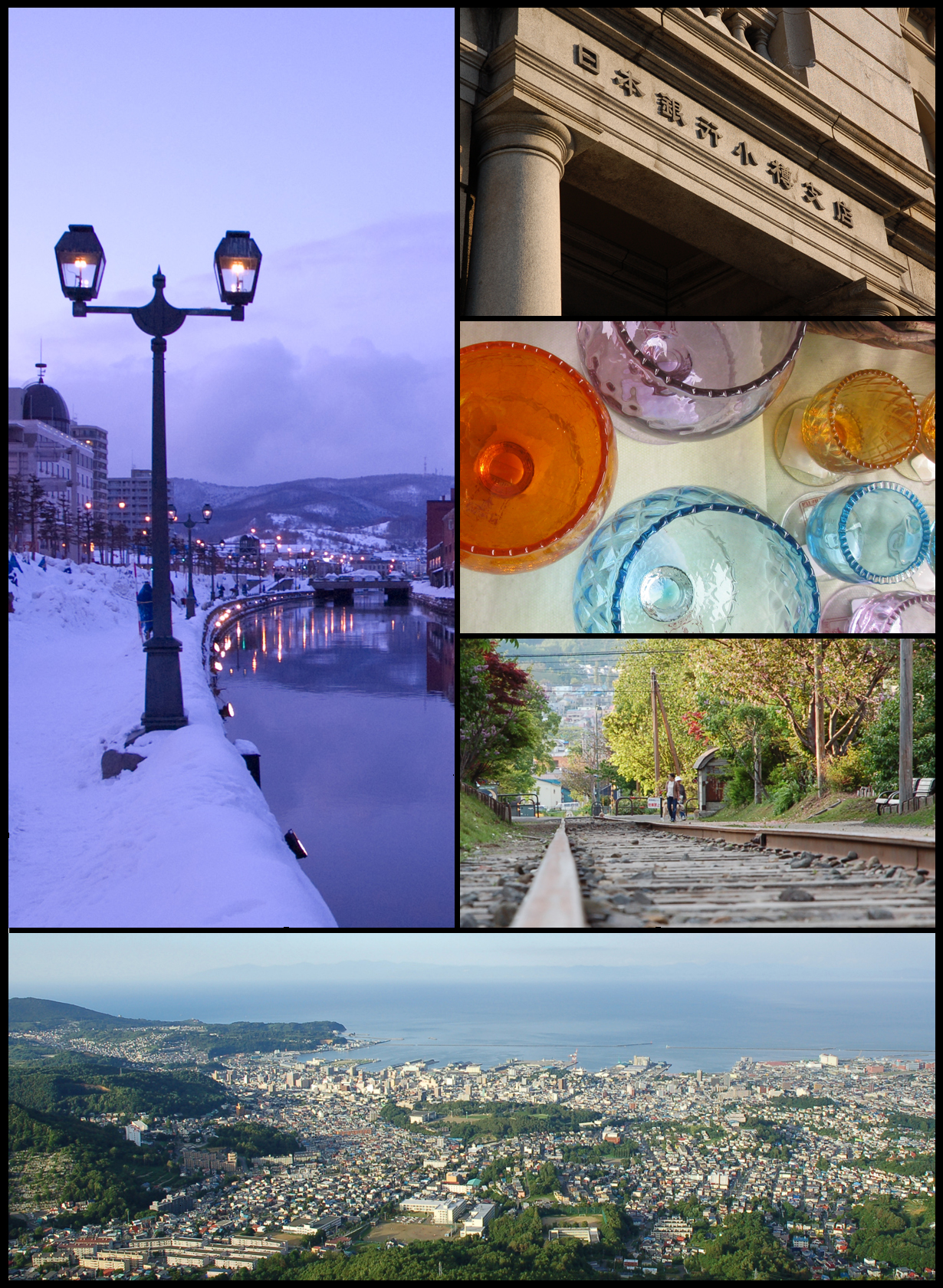 Top left: Otaru Canal Top right: The Bank of Japan Otaru Museum | |
 Flag  Seal | |
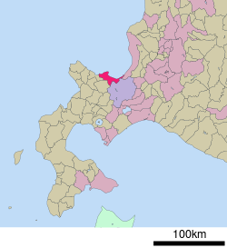 Location of Otaru in Hokkaido | |
 Otaru | |
| Coordinates: 43°11′N 141°0′E | |
| Country | Japan |
| Region | Hokkaido |
| Prefecture | Hokkaido (Shiribeshi Subprefecture) |
| Government | |
| • Mayor | Toshiya Hazama (from August 2018) |
| Area | |
| • Total | 243.13 km2 (93.87 sq mi) |
| Population (July 31, 2019) | |
| • Total | 115,333 |
| • Density | 474.37/km2 (1,228.6/sq mi) |
| Time zone | UTC+9 (Japan Standard Time) |
| Phone number | 0134-32-4111 |
| Address | 2-12-1 Hanazono, Otaru-shi, Hokkaido 047-8660 |
| Climate | Dfb |
| Website | www.city.otaru.lg.jp |
| Symbols | |
| Bird | Aobato (Japanese Green Pigeon) |
| Flower | Azalea |
| Tree | Shirakaba (Siberian Silver Birch) |
As of July 31, 2019, the city has an estimated population of 115,333 and a population density of 474.37 persons per km2 (1,228.6 persons per sq. mi.). The total area is 243.13 km2 (93.87 sq mi). Although it is the largest city in Shiribeshi Subprefecture, the subprefecture's capital is the more centrally located Kutchan.
History
The city was an Ainu habitation, and the name "Otaru" is recognised as being of Ainu origin, possibly meaning "River running through the sandy beach". The very small remaining part of the Temiya Cave contains carvings from the Zoku-Jōmon period of Ainu history, around A.D. 400. Mount Akaiwa (Northwest part of Otaru) is memorialized in the Ainu tradition in the story of Sitonai, village chief's teenage daughter who had slain a white snake from the mountain's cave that demanded sacrifices of girls every year.[1][2] The legend explains the name of a big cave on Mount Akaiwa, Hakuryu Gongen Cave (白竜権現洞窟, lit. White Dragon Gongen Cave) and the reason why a shrine was built on the mountain (to protect the village from being haunted by the snake).[2]
Otaru was recognised as a village by the bakufu in 1865, and in 1880 the first railway line in Hokkaido was opened with daily service between Otaru and Sapporo.
An Imperial decree in July 1899 established Otaru as an open port for trading with the United States and the United Kingdom.[3]
The city flourished well as the financial and business center in Hokkaido as well as the trade port with Japanese ruled southern Sakhalin until the 1920s. Otaru was redesignated as a city on August 1, 1922.
On December 26, 1924, a freight train loaded with 600 cases of dynamite exploded in Temiya Station, damaging the warehouse, the harbour facilities, and the surrounding area. Local officials stated that at least 94 were killed and 200 injured in this disaster.
During World War II, Otaru housed a prison camp for Aleuts taken there following the Japanese occupation of Attu.[4] During the closing stages of the war, Otaru was bombed by American naval aircraft in July 1945.[5]
Since the 1950s, as the coal industry around the city went into a decline, the status of the economic hub shifted from Otaru to Sapporo.
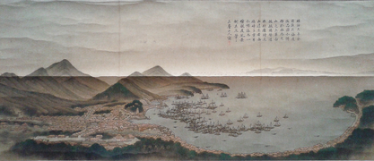 Otaru in 1876
 Otaru in 1909
 Otaru port in 1909
 Former Bank of Japan Otaru Branch, now home to the Otaru Museum


Geography

Otaru is a port town on the coast of the Sea of Japan in northern Shiribeshi Subprefecture. The southern portion of the city is characterized by the steep slopes of various mountains (notably Tenguyama), where the altitude of the land sharply drops from the mountains to the sea. The land available between the coast and mountains has been almost completely developed, and the developed part of the city on the mountain slopes is called Saka-no-machi, or "Hill town", including hills named Funamizaka (Boat-view Hill) and Jigokuzaka (Hell Hill).

Neighboring cities and towns
Rivers
Some of the rivers in Otaru are: Hoshioki, Kiraichi, Zenibako, Hariusu, Asari, Katsunai, Shioya, Myoken, Irifune.
Climate
In the summer the weather, like all of western Hokkaido, is very warm and balmy, with a maximum temperature of around 25 °C (77 °F) and high humidity – not as hot as southern Japan. In the winter, however, Otaru is very snowy, receiving as much as 6.6 metres (260 in) of snow from November to March, when it snows almost constantly and sunshine levels are extremely low. The average maximum snow cover is 1.22 metres (48 in). Extreme temperatures have ranged from 36.2 °C (97.2 °F) on July 28, 2021,[6] to −18.0 °C (−0.4 °F) on January 24, 1954, in which month the highest snowfall of 3.1 metres (122 in) occurred.[7] Monthly precipitation totals in a record dating back to 1943 have ranged from 379.8 millimetres (15.0 in) in August 1962 to 12.0 millimetres (0.5 in) in June 2007.[7]
| Climate data for Otaru, 1991–2020 normals, extremes 1943–present | |||||||||||||
|---|---|---|---|---|---|---|---|---|---|---|---|---|---|
| Month | Jan | Feb | Mar | Apr | May | Jun | Jul | Aug | Sep | Oct | Nov | Dec | Year |
| Record high °C (°F) | 11.0 (51.8) |
12.1 (53.8) |
16.9 (62.4) |
27.6 (81.7) |
30.2 (86.4) |
31.9 (89.4) |
36.2 (97.2) |
34.9 (94.8) |
33.6 (92.5) |
25.7 (78.3) |
21.8 (71.2) |
15.2 (59.4) |
36.2 (97.2) |
| Average high °C (°F) | −0.5 (31.1) |
−0.2 (31.6) |
4.1 (39.4) |
10.9 (51.6) |
16.9 (62.4) |
20.4 (68.7) |
24.2 (75.6) |
25.6 (78.1) |
22.3 (72.1) |
15.9 (60.6) |
8.3 (46.9) |
1.6 (34.9) |
12.5 (54.4) |
| Daily mean °C (°F) | −3.1 (26.4) |
−2.7 (27.1) |
0.8 (33.4) |
6.5 (43.7) |
12.1 (53.8) |
16.0 (60.8) |
20.2 (68.4) |
21.7 (71.1) |
18.1 (64.6) |
11.8 (53.2) |
4.9 (40.8) |
−1.1 (30.0) |
8.8 (47.8) |
| Average low °C (°F) | −5.8 (21.6) |
−5.7 (21.7) |
−2.4 (27.7) |
2.6 (36.7) |
7.9 (46.2) |
12.5 (54.5) |
17.1 (62.8) |
18.4 (65.1) |
14.3 (57.7) |
7.9 (46.2) |
1.6 (34.9) |
−3.8 (25.2) |
5.4 (41.7) |
| Record low °C (°F) | −18.0 (−0.4) |
−17.2 (1.0) |
−14.1 (6.6) |
−6.4 (20.5) |
0.0 (32.0) |
4.5 (40.1) |
9.0 (48.2) |
8.9 (48.0) |
2.6 (36.7) |
−1.4 (29.5) |
−9.1 (15.6) |
−13.5 (7.7) |
−18.0 (−0.4) |
| Average precipitation mm (inches) | 138.1 (5.44) |
106.6 (4.20) |
87.3 (3.44) |
56.4 (2.22) |
53.7 (2.11) |
55.6 (2.19) |
93.6 (3.69) |
131.3 (5.17) |
131.7 (5.19) |
123.0 (4.84) |
152.4 (6.00) |
151.9 (5.98) |
1,281.6 (50.47) |
| Average snowfall cm (inches) | 157 (62) |
130 (51) |
80 (31) |
7 (2.8) |
0 (0) |
0 (0) |
0 (0) |
0 (0) |
0 (0) |
0 (0) |
36 (14) |
142 (56) |
552 (216.8) |
| Average precipitation days (≥ 1.0 mm) | 22.8 | 18.6 | 16.1 | 10.0 | 9.0 | 7.4 | 8.3 | 9.6 | 11.3 | 14.1 | 18.1 | 21.7 | 167 |
| Average snowy days (≥ 1 cm) | 23.0 | 19.1 | 15.7 | 2.5 | 0 | 0 | 0 | 0 | 0 | 0.1 | 6.3 | 19.8 | 86.5 |
| Average relative humidity (%) | 71 | 70 | 66 | 64 | 69 | 78 | 81 | 78 | 73 | 69 | 69 | 71 | 72 |
| Mean monthly sunshine hours | 63.5 | 78.2 | 128.8 | 175.5 | 200.6 | 170.4 | 163.3 | 167.7 | 159.8 | 139.7 | 79.6 | 59.0 | 1,586.2 |
| Source: Japan Meteorological Agency[8][9] | |||||||||||||
List of mayors (from 1923 to present)
| Name | In office |
|---|---|
| Tota Sayanagi (佐柳藤太) | August 16, 1923 – February 25, 1925 |
| Fumihiko Kitagawa (木田川奎彦) | September 19, 1925 – November 11, 1932 |
| Miyakichi Itaya (板谷宮吉) | December 11, 1933 – December 10, 1937 |
| Naotaka Kawahara (河原直孝) | April 5, 1938 – May 10, 1945 |
| Kokichi Fukuoka (福岡幸吉) | June 1, 1945 – November 12, 1946 |
| Eitaro Suhara (寿原英太郎) | April 2, 1947 – April 6, 1951 |
| Yogoro Adachi (安達与五郎) | April 25, 1951 – April 29, 1967 |
| Name | In office |
|---|---|
| Yu Inagaki (稲垣祐) | April 30, 1967 – April 29, 1975 |
| Kazuo Shimura (志村和雄) | April 30, 1975 – April 29, 1987 |
| Masaaki Shintani (新谷昌明) | April 30, 1987 – April 29, 1999 |
| Katsuma Yamada (山田勝麿) | April 30, 1999 – April 29, 2011 |
| Yoshiharu Nakamatsu (中松義治) | April 30, 2011 – April 29, 2015 |
| Hideaki Morii (森井秀明) | April 30, 2015 – August 25, 2018 |
| Toshiya Hazama (迫俊哉) | August 26, 2018 – present |
Transportation
- JR Hokkaido Station
- Hakodate Main Line : Ranshima – Shioya – Otaru – Minami-Otaru – Otaru-Chikkō – Asari – Zenibako
- Otaru Port Ferry Terminal(A Shin Nihonkai Ferry operates two ferries daily)
Education
Universities
National
- Otaru University of Commerce
Colleges
- Otaru Junior College
High schools
Public
- Hokkaido Otaru Choryo High School
- Hokkaido Otaru Ouyou High School
- Hokkaido Otaru Fisheries High School
- Hokkaido Otaru Create Futures High School
Former
- Hokkaido Otaru Commercial High School
- Hokkaido Otaru Technical High School
Private
- Futaba Gakuen High School
- Hokusho High School
- Otaru Meihou High School
Notable attractions
This section needs additional citations for verification. (March 2021) |

A canal adorned with Victorian-style street lamps runs through Otaru. The city attracts a large number of Japanese tourists as well as Russian visitors.
A popular attraction on the west side of the city is Nishin Goten (herring mansion). This large wooden building was built in 1897 and was once the house of Fukumatsu Tanaka, a magnate of the fishing industry. It was originally built in nearby Tomari village and moved in 1958. Visitors can clearly see the difference between the squalid conditions of the first floor sleeping quarters of 120 workers and the ground floor luxury of the magnate's rooms.
Another notable building is the Sakaushi residence, constructed by Yoshiya Tanoue, a pupil of Frank Lloyd Wright.[10][11]
The Tomioka Catholic church is also a popular spot. Many of the buildings have been designated as landmark architecture.[12][clarification needed]
Otaru is well known for its beer, and Otaru Beer, next to the canal, is a popular restaurant with a medieval theme. Otaru is also known for its freshness sushi. Another food attraction unique to Otaru is the rainbow tower ice cream. The town also has substantial shopping arcades and bazaars, but fewer than nearby Sapporo.
Otaru's prominent industries are arts and crafts, such as studio glass and musical boxes. Of the latter, it maintains the Otaru Music Box Museum.
Tenguyama

Otaru is an important port for Sapporo, and part of this hilly city is on the lower slopes of Tenguyama, a good place for skiing and other winter sports and one that is accessible via Otaru Tenguyama Ropeway.
Sister cities
 Nakhodka, Russia[13]
 Dunedin, New Zealand
 Gangseo District, Seoul, South Korea
Notable people
- Seiji Aochi, ski jumper and Olympic medalist (1972 Winter Olympics)
- Yōko Asagami, Japanese voice actress (Space Battleship Yamato and City Hunter)
- Gennosuke Fuse, anatomist of the Meiji period
- Sei Itō, Japanese poet, novelist, and translator
- Chiaki Kawamata, Japanese science fiction writer and critic (Emblem of Roto)
- Yukie Kawamura, Japanese gravure idol, tarento, and actress
- Hinako Kitano, actress and model (ex-Nogizaka46)
- Masaki Kobayashi, Japanese film director (The Human Condition, Harakiri, Samurai Rebellion and Kwaidan)
- Takiji Kobayashi, Japanese author of proletarian literature
- Masaru Konuma, Japanese film director (Roman Porno)
- Kōtetsuyama Toyoya, sumo wrestler (Real Name: Kōnoshin Suga, Nihongo: 菅 孝之進, Suga Kōnoshin)
- Natsuhiko Kyogoku, Japanese mystery writer, member of the Mystery Writers of Japan and the Honkaku Mystery Writers Club of Japan
- Motosaburo Masuyama, Japanese statistician
- Hideharu Miyahira, ski jumper
- Nobuko Miyamoto, Japanese actress
- Tetsuya Mizuguchi, video game designer and co-founder of Q Entertainment
- Takiko Mizunoe, Japanese actress, film producer, radio personality and TV presenter
- Maki Murakami, Japanese manga artist (Gravitation)
- Hideo Murota, Japanese actor (Shinde mo ii)
- Nobuo Nakamura, Japanese actor (Ikiru and Tokyo Story)
- Tetsuya Okabe, Alpine ski racer
- Hibiki Ōtsuki, Japanese AV actress and idol singer
- Sarah Midori Perry, musician (Kero Kero Bonito)
- Yoko Takahashi, Japanese female mixed martial arts fighter, kickboxer and former boxer and professional wrestler
- Miyoshi Umeki, Academy Award-winning Japanese actress and standards singer
- Hirokazu Yagi, ski jumper
- Akiko Yamanaka, Japanese politician
- Ichiro Yamaguchi, musician (Sakanaction)
- Sawao Yamanaka, musician (The Pillows)
- Kazumi Yamashita, manga artist (The Life of Genius Professor Yanagizawa)
See also
- Otaru Station
- Otaru University of Commerce
- Rising Sun Rock Festival
- [Otaru Amato]
References
- metasato. "小樽 大蛇を殺した娘". 虫の知らせ ― 北海道の雨乞い、龍神信仰リサーチ ― (in Japanese). Retrieved October 31, 2020.
- "白龍権現" (in Japanese). Retrieved October 31, 2020.
- US Department of State. (1906). A digest of international law as embodied in diplomatic discussions, treaties, and other international agreements (John Bassett Moore, ed.), Vol. 5, p. 759.
- Breu, Mary (2009). Last Letters from Attu: The True Story of Etta Jones, Alaska Pioneer and Japanese POW. Portland: Graphic Arts Books. p. 296. ISBN 978-0-88240-852-1.
- The Asahi Shimbun. "朝日新聞デジタル:空襲の記憶 風化させぬ - 北海道 - 地域". www.asahi.com (in Japanese). Archived from the original on April 13, 2022. Retrieved April 13, 2022.
- "47411: Otaru (Japan)". ogimet.com. OGIMET. July 28, 2021. Retrieved July 28, 2021.
- "観測史上1~10位の値(年間を通じての値)". Data.jma.go.jp. Retrieved August 20, 2014.[permanent dead link]
- 観測史上1~10位の値(年間を通じての値). JMA. Retrieved February 16, 2022.
- 気象庁 / 平年値(年・月ごとの値). JMA. Retrieved February 16, 2022.
- "Npo 小樽ワークス". Archived from the original on November 4, 2011. Retrieved November 12, 2015.
- http://www.city.otaru.lg.jp.e.go.hp.transer.com/simin/gakushu_sports/kenzo/f_s/f_s74.html
- http://www.city.otaru.lg.jp.e.go.hp.transer.com/simin/gakushu_sports/kenzo/f_s/f_s70.html
- "Sister Cities of Otaru".
External links
- Official Website (in Japanese)
Sapporo (capital) | ||||||||||||
| ||||||||||||
| ||||||||||||
| ||||||||||||
| ||||||||||||
| ||||||||||||
| ||||||||||||
| ||||||||||||
| ||||||||||||
| ||||||||||||
| ||||||||||||
| ||||||||||||
| ||||||||||||
| ||||||||||||
| ||||||||||||
List of mergers in Hokkaido | ||||||||||||
Authority control | |
|---|---|
| General | |
| National libraries | |
| Other |
|
На других языках
[de] Otaru
Otaru (jap. .mw-parser-output .Hani{font-size:110%}小樽市, -shi) ist eine Stadt etwa 30 km westlich von Sapporo auf der japanischen Insel Hokkaidō in der Unterpräfektur Shiribeshi. Obwohl in Otaru mehr als die Hälfte der Gesamtbevölkerung der Unterpräfektur lebt, ist Kutchan der Sitz der Unterpräfekturverwaltung.- [en] Otaru
[es] Otaru (Hokkaidō)
Otaru (小樽市, Otaru-shi?) es una ciudad de la prefectura de Hokkaidō, en Japón. Es puerto nacional e internacional, especialmente con Rusia. Había sido el centro de tráfico y monetario de Hokkaidō en la primera mitad del siglo XX. Hoy es conocido como la ciudad del canal. Su población es 137.693 en 2008. El área total es 243,13km².[ru] Отару
Ота́ру[1] (яп. 小樽市 Отару-си) — портовый город, расположенный в округе Сирибэси на юго-западе японского острова Хоккайдо. Город расположен на берегу залива Исикари и долгое время являлся крупнейшим портом залива. Отару — крупный туристический центр, по сути, представляющий собой пригород Саппоро.Другой контент может иметь иную лицензию. Перед использованием материалов сайта WikiSort.org внимательно изучите правила лицензирования конкретных элементов наполнения сайта.
WikiSort.org - проект по пересортировке и дополнению контента Википедии