world.wikisort.org - Japan
Hamatonbetsu (浜頓別町, Hamatonbetsu-chō) is a town located in Sōya Subprefecture, Hokkaido, Japan. As of September 2016, the town has an estimated population of 3,841, an area of 401.56 square kilometres (155.04 sq mi).[1], and a density of 9.6 persons per km². The town is in a long period of sustained population loss.[2] It is the location of Lake Kutcharo, a freshwater wetlands area used by thousands of swans making their winter migration from northern Siberia to Japan.
Hamatonbetsu
浜頓別町 | |
|---|---|
Town | |
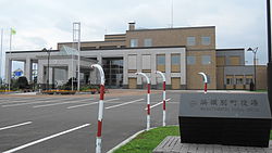
 Hamatonbetsu town hall | |
 Flag  Chapter seal | |
 Location of Hamatonbetsu in Hokkaido (Sōya Subprefecture) | |
 Hamatonbetsu Location in Japan | |
| Coordinates: 45°7′N 142°22′E | |
| Country | Japan |
| Region | Hokkaido |
| Prefecture | Hokkaido (Sōya Subprefecture) |
| District | Esashi |
| Area | |
| • Total | 401.56 km2 (155.04 sq mi) |
| Population (September 30, 2016) | |
| • Total | 3,841 |
| • Density | 9.6/km2 (25/sq mi) |
| Time zone | UTC+09:00 (JST) |
| Climate | Dfb |
| Website | www |
Geography
Climate
| Climate data for Hamatonbetsu (1991−2020 normals, extremes 1977−present) | |||||||||||||
|---|---|---|---|---|---|---|---|---|---|---|---|---|---|
| Month | Jan | Feb | Mar | Apr | May | Jun | Jul | Aug | Sep | Oct | Nov | Dec | Year |
| Record high °C (°F) | 8.2 (46.8) |
9.3 (48.7) |
15.9 (60.6) |
23.6 (74.5) |
29.7 (85.5) |
30.6 (87.1) |
33.6 (92.5) |
33.4 (92.1) |
30.9 (87.6) |
24.7 (76.5) |
19.0 (66.2) |
10.2 (50.4) |
33.6 (92.5) |
| Average high °C (°F) | −3.3 (26.1) |
−2.6 (27.3) |
1.4 (34.5) |
8.0 (46.4) |
13.7 (56.7) |
16.9 (62.4) |
20.7 (69.3) |
22.8 (73.0) |
20.3 (68.5) |
14.1 (57.4) |
5.6 (42.1) |
−1.0 (30.2) |
9.7 (49.5) |
| Daily mean °C (°F) | −6.3 (20.7) |
−6.3 (20.7) |
−2.0 (28.4) |
4.0 (39.2) |
9.2 (48.6) |
12.8 (55.0) |
16.9 (62.4) |
19.0 (66.2) |
15.8 (60.4) |
9.6 (49.3) |
2.4 (36.3) |
−3.8 (25.2) |
5.9 (42.7) |
| Average low °C (°F) | −10.3 (13.5) |
−11.1 (12.0) |
−6.1 (21.0) |
0.1 (32.2) |
4.9 (40.8) |
9.0 (48.2) |
13.7 (56.7) |
15.7 (60.3) |
11.7 (53.1) |
5.3 (41.5) |
−1.0 (30.2) |
−7.2 (19.0) |
2.1 (35.7) |
| Record low °C (°F) | −27.4 (−17.3) |
−27.4 (−17.3) |
−24.6 (−12.3) |
−10.2 (13.6) |
−4.2 (24.4) |
−2.0 (28.4) |
1.0 (33.8) |
4.0 (39.2) |
1.9 (35.4) |
−4.1 (24.6) |
−16.8 (1.8) |
−19.5 (−3.1) |
−27.4 (−17.3) |
| Average precipitation mm (inches) | 62.1 (2.44) |
46.7 (1.84) |
50.2 (1.98) |
47.6 (1.87) |
61.0 (2.40) |
65.0 (2.56) |
116.9 (4.60) |
118.9 (4.68) |
121.4 (4.78) |
106.4 (4.19) |
101.9 (4.01) |
83.3 (3.28) |
997.0 (39.25) |
| Average rainy days | 17.5 | 15.1 | 13.5 | 10.6 | 10.8 | 10.2 | 11.3 | 11.7 | 13.1 | 14.5 | 17.7 | 19.2 | 165.2 |
| Mean monthly sunshine hours | 59.7 | 82.3 | 132.2 | 166.3 | 174.0 | 148.2 | 132.9 | 143.1 | 165.3 | 135.7 | 71.9 | 56.6 | 1,470.1 |
| Source 1: JMA[3] | |||||||||||||
| Source 2: JMA[4] | |||||||||||||
Education
Hamatonbetsu has one local high school and a junior high school, as well as a kindergarten and nursery school within the town limits. The Hamatonbetsu Board of Education also oversees four additional elementary schools and another junior high school. Shanai Elementary School, Toyokanbetsu Elementary School, Usotan Elementary School, Shimotombetsu Elementary School, and Shimotombetsu Junior High School are all included.
The town of Hamatonbetsu participates in the JET Programme.
Economy
Hamatonbetsu's local economy depends mainly on dairy farming and harvesting salmon, scallops, and crabs.
Within the town there is a park golf course and an onsen on the edge of Lake Kutcharo.
Transportation
Hamatonbetsu has a bus terminal. It was previously serviced by Hama-Tombetsu railway station on the Tempoku Line until the line and station were abandoned on 1 May 1989. The nearest railway station is now Otoineppu Station to the south, a 1.5 hour bus ride away.
References
- "浜頓別(町)" [Hamatonbetsu]. Nihon Daihyakka Zensho (Nipponika) (in Japanese). Tokyo: Shogakukan. 2013. OCLC 153301537. Archived from the original on 2007-08-25. Retrieved 2013-09-06.
- 人口推移 [Population Change] (in Japanese). Hamatonbetsu, Hokkaido: Town of Hamatonbetsu. 2013. Retrieved 2013-09-10.
- 観測史上1~10位の値(年間を通じての値). JMA. Retrieved February 21, 2022.
- 気象庁 / 平年値(年・月ごとの値). JMA. Retrieved February 21, 2022.
External links
 Media related to Hamatonbetsu, Hokkaidō at Wikimedia Commons
- Official Website (in Japanese)
На других языках
- [en] Hamatonbetsu, Hokkaido
[ru] Хаматомбецу
Хаматомбе́цу (яп. 浜頓別町 Хаматомбэцу-тё:) — посёлок в Японии, находящийся в уезде Эсаси округа Соя губернаторства Хоккайдо. Площадь посёлка составляет 401,56 км²[1], население — 3994 человека (30 июня 2014)[2], плотность населения — 9,95 чел./км².Другой контент может иметь иную лицензию. Перед использованием материалов сайта WikiSort.org внимательно изучите правила лицензирования конкретных элементов наполнения сайта.
WikiSort.org - проект по пересортировке и дополнению контента Википедии