world.wikisort.org - Japan
Tsurui (鶴居村, Tsurui-mura) is a village located in Kushiro Subprefecture, Hokkaido. As of September 30, 2016, it has an estimated population of 2,516, and an area of 571.84 km2.
 | This article needs additional citations for verification. (March 2022) |
 | This article may be expanded with text translated from the corresponding article in Japanese. (June 2022) Click [show] for important translation instructions.
|
Tsurui
鶴居村 | |
|---|---|
Village | |
 Tsurui village hall | |
 Flag  Seal | |
 Location of Tsurui in Hokkaido (Kushiro Subprefecture) | |
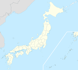  Tsurui Location in Japan | |
| Coordinates: 43°14′N 144°19′E | |
| Country | Japan |
| Region | Hokkaido |
| Prefecture | Hokkaido (Kushiro Subprefecture) |
| District | Akan |
| Area | |
| • Total | 571.84 km2 (220.79 sq mi) |
| Population (September 30, 2016) | |
| • Total | 2,516 |
| • Density | 4.4/km2 (11/sq mi) |
| Time zone | UTC+09:00 (JST) |
| Climate | Dfb |
| Website | www |
Tsurui is a breeding ground for the red-crowned crane, one of the 100 Soundscapes of Japan.[1]
History
The village was formed in 1937.
Climate
| Climate data for Tsurui (1991−2020 normals, extremes 1977−present) | |||||||||||||
|---|---|---|---|---|---|---|---|---|---|---|---|---|---|
| Month | Jan | Feb | Mar | Apr | May | Jun | Jul | Aug | Sep | Oct | Nov | Dec | Year |
| Record high °C (°F) | 7.4 (45.3) |
10.1 (50.2) |
16.3 (61.3) |
27.1 (80.8) |
35.0 (95.0) |
32.0 (89.6) |
34.7 (94.5) |
35.1 (95.2) |
32.0 (89.6) |
26.1 (79.0) |
21.0 (69.8) |
13.1 (55.6) |
35.1 (95.2) |
| Average high °C (°F) | −0.8 (30.6) |
−0.3 (31.5) |
3.8 (38.8) |
10.1 (50.2) |
15.8 (60.4) |
18.9 (66.0) |
22.2 (72.0) |
23.7 (74.7) |
21.1 (70.0) |
15.7 (60.3) |
8.7 (47.7) |
1.8 (35.2) |
11.7 (53.1) |
| Daily mean °C (°F) | −7.1 (19.2) |
−6.5 (20.3) |
−1.7 (28.9) |
4.0 (39.2) |
9.4 (48.9) |
13.3 (55.9) |
17.2 (63.0) |
18.7 (65.7) |
15.7 (60.3) |
9.4 (48.9) |
2.5 (36.5) |
−4.4 (24.1) |
5.9 (42.6) |
| Average low °C (°F) | −13.9 (7.0) |
−13.8 (7.2) |
−7.8 (18.0) |
−1.8 (28.8) |
3.6 (38.5) |
8.8 (47.8) |
13.4 (56.1) |
14.9 (58.8) |
10.8 (51.4) |
3.2 (37.8) |
−3.6 (25.5) |
−10.8 (12.6) |
0.3 (32.5) |
| Record low °C (°F) | −27.2 (−17.0) |
−26.9 (−16.4) |
−21.4 (−6.5) |
−13.5 (7.7) |
−7.0 (19.4) |
−2.4 (27.7) |
0.9 (33.6) |
5.9 (42.6) |
−0.2 (31.6) |
−6.6 (20.1) |
−15.5 (4.1) |
−22.5 (−8.5) |
−27.2 (−17.0) |
| Average precipitation mm (inches) | 47.9 (1.89) |
30.0 (1.18) |
70.1 (2.76) |
87.7 (3.45) |
122.8 (4.83) |
112.2 (4.42) |
136.6 (5.38) |
168.8 (6.65) |
170.9 (6.73) |
123.8 (4.87) |
75.7 (2.98) |
61.9 (2.44) |
1,203.6 (47.39) |
| Average snowfall cm (inches) | 80 (31) |
72 (28) |
82 (32) |
26 (10) |
1 (0.4) |
0 (0) |
0 (0) |
0 (0) |
0 (0) |
0 (0) |
8 (3.1) |
62 (24) |
332 (131) |
| Average precipitation days (≥ 1.0 mm) | 5.7 | 4.7 | 7.5 | 9.0 | 10.5 | 9.7 | 11.1 | 11.6 | 12.0 | 8.8 | 8.1 | 6.8 | 105.5 |
| Average snowy days (≥ 3 cm) | 9.4 | 9.1 | 10.7 | 3.6 | 0.2 | 0 | 0 | 0 | 0 | 0 | 1.0 | 7.6 | 41.6 |
| Mean monthly sunshine hours | 148.8 | 151.6 | 176.4 | 169.0 | 170.5 | 134.7 | 109.5 | 120.2 | 131.9 | 160.9 | 151.7 | 146.1 | 1,768.4 |
| Source: Japan Meteorological Agency[2][3] | |||||||||||||
Mascots

Tsurui's mascots are Tsurubo (つるぼー) and Hinabo (ひなぼー). They are red-crowned crane brothers. They are shaped like bogs of the Kushiro-shitsugen National Park.[4][5]
- Tsurubo is the oldest of the siblings. His tail resembles a cosmos flower.
- Hinabo is the youngest of the siblings.
References
- Rich, Motoko; Hida, Hikari; Delano, James Whitlow (2022-03-21). "These Revered Cranes Escaped Extinction. Can They Survive Without Humans?". The New York Times. ISSN 0362-4331. Retrieved 2022-03-23.
- 観測史上1~10位の値(年間を通じての値). JMA. Retrieved March 3, 2022.
- 気象庁 / 平年値(年・月ごとの値). JMA. Retrieved March 3, 2022.
- "つるぼー (北海道)". Yuru-Chara Grand Prix.
- "つるぼーのプロフィール(鶴居村)". Kawaii Hokkaido.
External links
 Media related to Tsurui, Hokkaidō at Wikimedia Commons
- Official Website (in Japanese)

 Hokkaido Hokkaido | ||||||||||||
|---|---|---|---|---|---|---|---|---|---|---|---|---|
Sapporo (capital) | ||||||||||||
|  | |||||||||||
|
| ||||||||||||
| ||||||||||||
| ||||||||||||
| ||||||||||||
| ||||||||||||
| ||||||||||||
| ||||||||||||
| ||||||||||||
| ||||||||||||
| ||||||||||||
| ||||||||||||
| ||||||||||||
List of mergers in Hokkaido | ||||||||||||
Authority control | |
|---|---|
| General | |
| National libraries | |

 | This Hokkaidō location article is a stub. You can help Wikipedia by expanding it. |
На других языках
- [en] Tsurui
[ru] Цуруи
Цуруи (яп. 鶴居村 Цуруи-мура) — село в Японии, находящееся в уезде Акан округа Кусиро губернаторства Хоккайдо. Площадь села составляет 571,84 км²[1], население — 2529 человек (30 июня 2014)[2], плотность населения — 4,42 чел./км².Текст в блоке "Читать" взят с сайта "Википедия" и доступен по лицензии Creative Commons Attribution-ShareAlike; в отдельных случаях могут действовать дополнительные условия.
Другой контент может иметь иную лицензию. Перед использованием материалов сайта WikiSort.org внимательно изучите правила лицензирования конкретных элементов наполнения сайта.
Другой контент может иметь иную лицензию. Перед использованием материалов сайта WikiSort.org внимательно изучите правила лицензирования конкретных элементов наполнения сайта.
2019-2026
WikiSort.org - проект по пересортировке и дополнению контента Википедии
WikiSort.org - проект по пересортировке и дополнению контента Википедии