world.wikisort.org - Japan
Horokanai (幌加内町, Horokanai-chō) is a town in Kamikawa Subprefecture, Hokkaido, Japan. As of September 2016, the town has an estimated population of 1,571. The total area is 767.03 km2 (296.15 sq mi).
 | This article may be expanded with text translated from the corresponding article in Japanese. (June 2022) Click [show] for important translation instructions.
|
Horokanai
幌加内町 | |
|---|---|
Town | |
 Horokanai town hall | |
 Flag  Emblem | |
 Location of Horokanai in Hokkaido (Kamikawa Subprefecture) | |
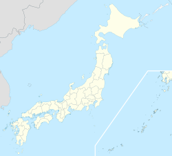  Horokanai Location in Japan | |
| Coordinates: 44°1′N 142°9′E | |
| Country | Japan |
| Region | Hokkaido |
| Prefecture | Hokkaido (Kamikawa Subprefecture) |
| District | Uryū |
| Area | |
| • Total | 767.03 km2 (296.15 sq mi) |
| Population (September 30, 2016) | |
| • Total | 1,571 |
| • Density | 2.0/km2 (5.3/sq mi) |
| Time zone | UTC+09:00 (JST) |
| Website | www |
History
On April 1, 2010, Horokanai was transferred from Sorachi Subprefecture to Kamikawa Subprefecture.
Culture
Mascot

Horokanai's mascot is Horomin (ほろみん). She is a healthy and hard working buckwheat seed. She carries a soba choko and chopsticks to eat her homemade soba noodles. She wears traditional Japanese chef clothing and a buckwheat flower on her head. She carries is a huge stick (that doubles as a staff weapon) on her back. She is unveiled on 18 June 2013.[1]
Climate
Horokanai has a humid continental climate (Köppen: Dfb). On December 31, 2020, a minimum temperature of −32.6 °C (−26.7 °F) was registered.[2]
| Climate data for Horokanai (1991−2020 normals, extremes 1977−present) | |||||||||||||
|---|---|---|---|---|---|---|---|---|---|---|---|---|---|
| Month | Jan | Feb | Mar | Apr | May | Jun | Jul | Aug | Sep | Oct | Nov | Dec | Year |
| Record high °C (°F) | 6.1 (43.0) |
8.1 (46.6) |
11.8 (53.2) |
24.3 (75.7) |
32.3 (90.1) |
36.0 (96.8) |
37.3 (99.1) |
36.5 (97.7) |
31.5 (88.7) |
25.2 (77.4) |
18.9 (66.0) |
10.8 (51.4) |
37.3 (99.1) |
| Average high °C (°F) | −3.9 (25.0) |
−2.7 (27.1) |
1.7 (35.1) |
8.4 (47.1) |
16.7 (62.1) |
21.7 (71.1) |
25.2 (77.4) |
25.4 (77.7) |
21.0 (69.8) |
13.9 (57.0) |
5.2 (41.4) |
−1.7 (28.9) |
10.9 (51.6) |
| Daily mean °C (°F) | −8.4 (16.9) |
−7.7 (18.1) |
−3.0 (26.6) |
3.2 (37.8) |
10.5 (50.9) |
15.7 (60.3) |
19.7 (67.5) |
20.0 (68.0) |
15.3 (59.5) |
8.4 (47.1) |
1.5 (34.7) |
−5.2 (22.6) |
5.8 (42.5) |
| Average low °C (°F) | −14.5 (5.9) |
−14.5 (5.9) |
−9.2 (15.4) |
−2.2 (28.0) |
4.5 (40.1) |
10.5 (50.9) |
15.1 (59.2) |
15.5 (59.9) |
10.1 (50.2) |
3.3 (37.9) |
−2.4 (27.7) |
−9.8 (14.4) |
0.5 (33.0) |
| Record low °C (°F) | −36.1 (−33.0) |
−37.6 (−35.7) |
−31.4 (−24.5) |
−19.3 (−2.7) |
−4.8 (23.4) |
−0.4 (31.3) |
4.3 (39.7) |
5.1 (41.2) |
−0.1 (31.8) |
−7.1 (19.2) |
−21.7 (−7.1) |
−32.6 (−26.7) |
−37.6 (−35.7) |
| Average precipitation mm (inches) | 120.9 (4.76) |
97.3 (3.83) |
80.3 (3.16) |
63.4 (2.50) |
81.0 (3.19) |
71.1 (2.80) |
144.2 (5.68) |
161.4 (6.35) |
169.3 (6.67) |
161.0 (6.34) |
182.7 (7.19) |
171.3 (6.74) |
1,503.9 (59.21) |
| Average snowfall cm (inches) | 278 (109) |
231 (91) |
181 (71) |
48 (19) |
1 (0.4) |
0 (0) |
0 (0) |
0 (0) |
0 (0) |
4 (1.6) |
157 (62) |
326 (128) |
1,226 (482) |
| Average rainy days | 22.1 | 18.6 | 17.3 | 12.1 | 11.6 | 9.6 | 11.1 | 12.1 | 14.1 | 17.6 | 21.3 | 25.2 | 192.7 |
| Average snowy days | 22.1 | 19.2 | 17.1 | 6.3 | 0.2 | 0 | 0 | 0 | 0 | 0.6 | 11.2 | 23.3 | 100 |
| Mean monthly sunshine hours | 42.4 | 56.0 | 102.7 | 146.3 | 182.4 | 161.1 | 151.8 | 146.1 | 140.9 | 109.8 | 46.0 | 22.1 | 1,307.6 |
| Source 1: JMA[3] | |||||||||||||
| Source 2: JMA[4] | |||||||||||||
References
- "幌加内町イメージキャラクター「ほろみん」". Horokanai.
- Mori, Sayaka [@sayakasofiamori] (December 31, 2020). "Many new December records have been set on the New Year's eve in #Japan. The Hokuriku region could get an additional 260cm (8.5feet) of snow into the next three days. It's likely be a historic #snow event. t.co/83q7XI2a1i" (Tweet). Retrieved January 11, 2021 – via Twitter.
- 観測史上1~10位の値(年間を通じての値). JMA. Retrieved February 17, 2022.
- 気象庁 / 平年値(年・月ごとの値). JMA. Retrieved February 17, 2022.
External links
 Media related to Horokanai, Hokkaidō at Wikimedia Commons
- Official Website (in Japanese)

 Hokkaido Hokkaido | ||||||||||||
|---|---|---|---|---|---|---|---|---|---|---|---|---|
Sapporo (capital) | ||||||||||||
|  | |||||||||||
|
| ||||||||||||
| ||||||||||||
| ||||||||||||
| ||||||||||||
| ||||||||||||
| ||||||||||||
| ||||||||||||
| ||||||||||||
| ||||||||||||
| ||||||||||||
| ||||||||||||
| ||||||||||||
List of mergers in Hokkaido | ||||||||||||

 | This Hokkaidō location article is a stub. You can help Wikipedia by expanding it. |
На других языках
- [en] Horokanai, Hokkaido
[ru] Хороканай
Хороканай (яп. 幌加内町 Хороканай-тё:) — посёлок в Японии, находящийся в уезде Урю округа Камикава губернаторства Хоккайдо. Площадь посёлка составляет 767,03 км²[1], население — 1643 человека (30 июня 2014)[2], плотность населения — 2,14 чел./км².Другой контент может иметь иную лицензию. Перед использованием материалов сайта WikiSort.org внимательно изучите правила лицензирования конкретных элементов наполнения сайта.
WikiSort.org - проект по пересортировке и дополнению контента Википедии