world.wikisort.org - Japan
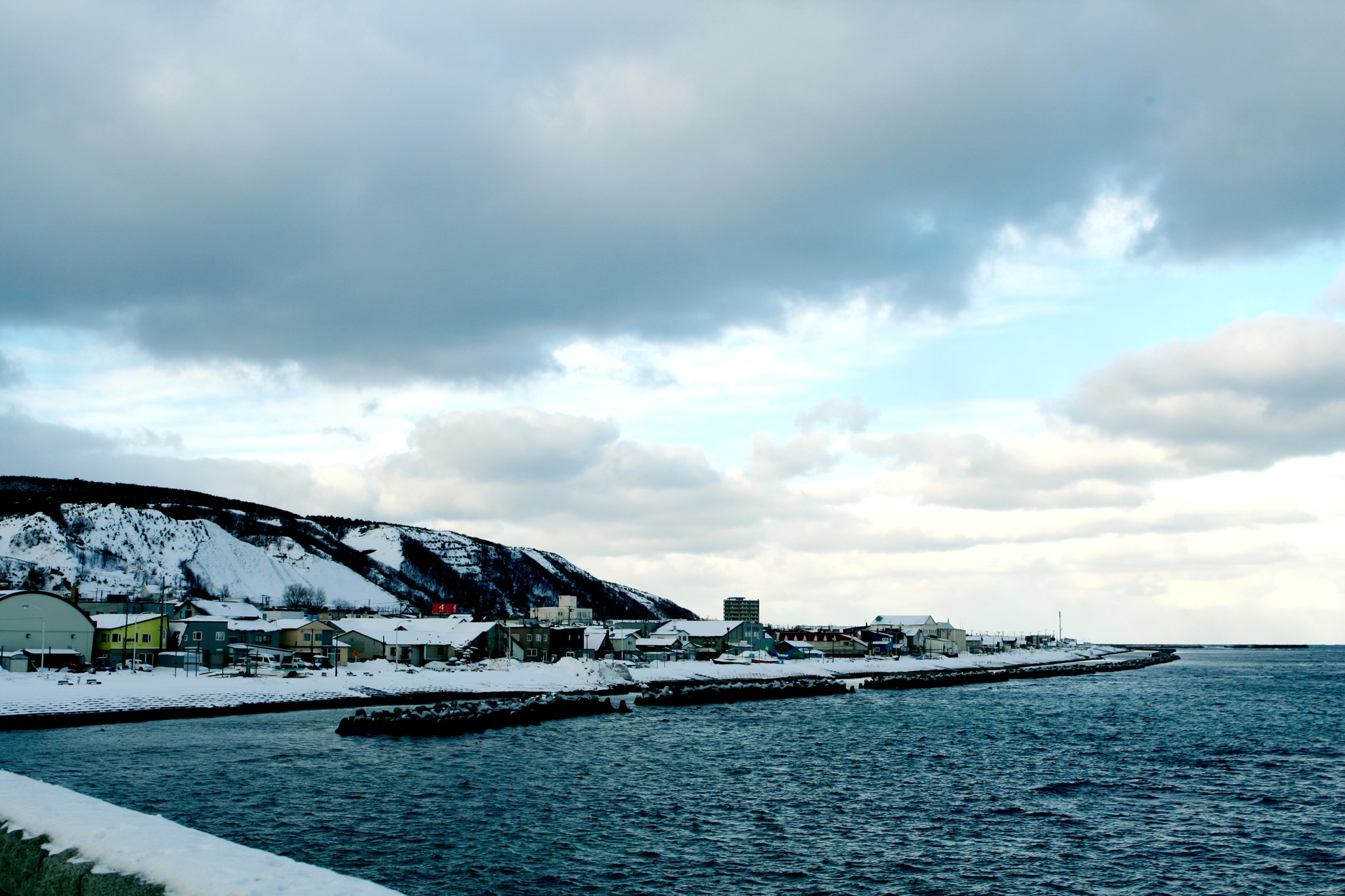
Wakkanai (稚内市, Wakkanai-shi, Ainu: ヤㇺワッカナイ Yam-wakka-nay meaning "cold water river")[1] is a city located in Sōya Subprefecture, Hokkaido, Japan. It is the capital of Sōya Subprefecture. It contains Japan's northernmost point, Cape Sōya, from which the Russian island of Sakhalin can be seen.
This article may be expanded with text translated from the corresponding article in Japanese. (June 2022) Click [show] for important translation instructions.
|
Wakkanai
稚内市 | |
|---|---|
City | |
| Wakkanai City | |
 Left: View of Wakkanai from Wakkanai Park, Wakkanai Ice Snow Gate, Cape Sōya Wind Farm, North Breakwater Dome Right: North Extreme Point monument in Cape Sōya, Wakkanai Lighthouse in Cape Nossapu, Wakkanai Train Station (all item from above to bottom) | |
 Flag  Seal | |
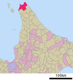 Location of Wakkanai in Hokkaido Prefecture, highlighted in pink | |
 Wakkanai | |
| Coordinates: 45°24′56.4″N 141°40′23″E | |
| Country | Japan |
| Region | Hokkaido |
| Prefecture | Hokkaido |
| Government | |
| • Mayor | Hiroshi Kudo (since May 2011) |
| Area | |
| • Total | 761.47 km2 (294.01 sq mi) |
| Population (June 1, 1975) | |
| • Total | 55,465 |
| • Density | 72.8/km2 (189/sq mi) |
| Time zone | UTC+9 (Japan Standard Time) |
| Phone number | 0162-23-6161 |
| Address | 3-13-15 Chūō, Wakkanai-shi, Hokkaido 097-8686 |
| Climate | Dfb |
| Website | www |
| Symbols | |
| Flower | Rosa rugosa |
| Tree | Sakura, rowan |
As of 1 June 1975, the city has an estimated population of 55,465 and a population density of 72.8 persons per km2 (189 persons per mi2). The total area is 761.47 km2 (294.01 sq mi).[2][3]
Wakkanai is also home to Japan's first nursing home built inside the central train station of its city, a novel approach to caring for Japan's growing elderly population that has since been imitated in several other cities.[4]
History
Wakkanai was originally home to an Ainu population. The first Japanese settlement was established in 1685.[5]
- 1879: The village of Wakkanai was founded.
- 1897: Sōya Subprefecture established.
- 1901: Wakkanai village became Wakkanai town.
- 1949: Wakkanai town became Wakkanai city.
- 1955: Soya village was merged into Wakkanai city.
- 1959: Wakkanai Airport opened.
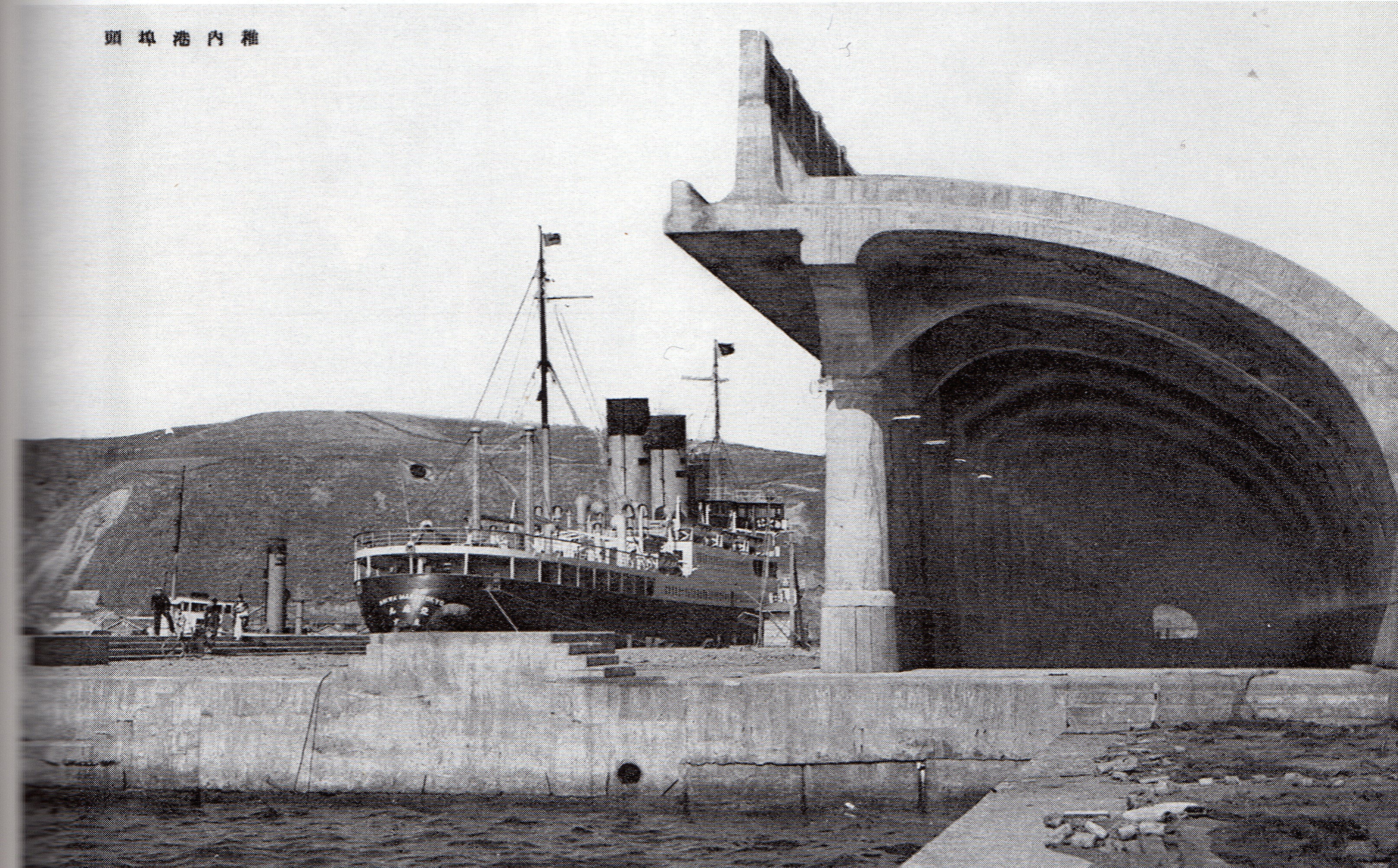
During World War II: The Imperial Japanese Navy used the harbor and port as a submarine base. Wakkanai was far enough north to be outside the range of American heavy bombers and was safe from air attack. Until the early to mid-1960s, the northern portion of the harbor remained divided by concrete sub-mooring pens. The large breakwater structure (which still exists) was actually a sub-repair facility. At the shore end there was a huge winching mechanism capable of hauling subs up into the partially enclosed structure where they could be repaired while completely out of the water. Built into the hills above the city there were several reinforced concrete bunker-type caves where (anecdotally) they were used either to store ammunition and armament, or as air raid shelters for the civilian populace. History would suggest the former use, rather than the latter. During a re-build/renovation of the harbor sometime during the 1960s or 1970s, the harbor was cleared of the concrete pens and the machinery was removed from the breakwater structure which was reconfigured.
Geography
Japan's northernmost point, Cape Sōya, is located in Wakkanai, which is on a peninsula jutting towards Sakhalin Island in Russia, which is 43 kilometers (27 miles) away. On a clear day, the Russian island can be easily seen. There is also an island called Benten-jima located northwest of Cape Sōya.
- Rivers: Koetoi River
- Lakes: Ōnuma Lake
Surrounding municipalities
Climate
Wakkanai has a humid continental climate (Köppen: Dfb) typical of Hokkaido but with strong influence of the ocean as island portions near the great land masses (such as the smaller islands of Nova Scotia),[6] with cold winters, warm summers and generally heavy precipitation from the Aleutian Low, whose winds hit the city direct from the Sea of Japan but with strong oceanic influence (46 °F). The winter is cold enough not to fall in a "Cfb" climate and the summers although very mild for typical climate "b" is warm enough to fall into a "Dfc", both in the classification of Koppen.[7] The mean annual temperature, at 6.8 °C (44.2 °F), is the second lowest for a significant population centre in Japan after Nemuro. Snowfall at 6.6 metres (260 in), the third highest for a big city in Japan after Asahikawa and Aomori and one of the highest anywhere in the world. For comparison, Nain in Canada receives 194 inches (4.9 m) of snow.[citation needed]
The Aleutian Low also makes the sunshine hours the lowest of Japan's major population centres and in the winter the wind speeds are the highest in Japan with an average of 20.2 km/h (12.6 mph), which adds to the −4.7 °C (23.5 °F) cold of a typical winter day. The city's port is usually usable throughout the year, but does occasionally freeze in cold winters.[citation needed]
The highest temperature ever recorded in Wakkanai was 32.7 °C (90.9 °F) on 29 July 2021.[8] The coldest temperature ever recorded was −19.4 °C (−2.9 °F) on 30 January 1944.[9]
| Climate data for Wakkanai (1991−2020 normals, extremes 1938−present) | |||||||||||||
|---|---|---|---|---|---|---|---|---|---|---|---|---|---|
| Month | Jan | Feb | Mar | Apr | May | Jun | Jul | Aug | Sep | Oct | Nov | Dec | Year |
| Record high °C (°F) | 7.4 (45.3) |
9.3 (48.7) |
13.1 (55.6) |
20.2 (68.4) |
26.9 (80.4) |
26.8 (80.2) |
32.7 (90.9) |
31.6 (88.9) |
29.7 (85.5) |
23.5 (74.3) |
17.4 (63.3) |
11.5 (52.7) |
32.7 (90.9) |
| Mean maximum °C (°F) | 3.1 (37.6) |
4.1 (39.4) |
7.9 (46.2) |
14.9 (58.8) |
20.1 (68.2) |
22.6 (72.7) |
25.6 (78.1) |
26.4 (79.5) |
25.0 (77.0) |
19.6 (67.3) |
13.9 (57.0) |
6.6 (43.9) |
27.2 (81.0) |
| Average high °C (°F) | −2.4 (27.7) |
−2.0 (28.4) |
1.6 (34.9) |
7.4 (45.3) |
12.4 (54.3) |
16.1 (61.0) |
20.1 (68.2) |
22.3 (72.1) |
20.1 (68.2) |
14.1 (57.4) |
6.3 (43.3) |
0.0 (32.0) |
9.7 (49.5) |
| Daily mean °C (°F) | −4.3 (24.3) |
−4.3 (24.3) |
−0.6 (30.9) |
4.5 (40.1) |
9.1 (48.4) |
13.0 (55.4) |
17.2 (63.0) |
19.5 (67.1) |
17.2 (63.0) |
11.3 (52.3) |
3.8 (38.8) |
−2.1 (28.2) |
7.0 (44.6) |
| Average low °C (°F) | −6.4 (20.5) |
−6.7 (19.9) |
−3.1 (26.4) |
1.8 (35.2) |
6.3 (43.3) |
10.4 (50.7) |
14.9 (58.8) |
17.2 (63.0) |
14.4 (57.9) |
8.4 (47.1) |
1.3 (34.3) |
−4.2 (24.4) |
4.5 (40.1) |
| Mean minimum °C (°F) | −11.4 (11.5) |
−11.7 (10.9) |
−8.6 (16.5) |
−2.7 (27.1) |
1.5 (34.7) |
5.9 (42.6) |
10.4 (50.7) |
13.6 (56.5) |
9.1 (48.4) |
2.4 (36.3) |
−5.7 (21.7) |
−9.4 (15.1) |
−12.5 (9.5) |
| Record low °C (°F) | −19.4 (−2.9) |
−18.3 (−0.9) |
−17.4 (0.7) |
−8.0 (17.6) |
−2.2 (28.0) |
2.1 (35.8) |
6.4 (43.5) |
8.9 (48.0) |
3.5 (38.3) |
−4.4 (24.1) |
−11.4 (11.5) |
−16.0 (3.2) |
−19.4 (−2.9) |
| Average precipitation mm (inches) | 84.6 (3.33) |
60.6 (2.39) |
55.1 (2.17) |
50.3 (1.98) |
68.1 (2.68) |
65.8 (2.59) |
100.9 (3.97) |
123.1 (4.85) |
136.7 (5.38) |
129.7 (5.11) |
121.4 (4.78) |
112.9 (4.44) |
1,109.2 (43.67) |
| Average snowfall cm (inches) | 129 (51) |
105 (41) |
68 (27) |
9 (3.5) |
0 (0) |
0 (0) |
0 (0) |
0 (0) |
0 (0) |
1 (0.4) |
41 (16) |
122 (48) |
477 (188) |
| Average precipitation days (≥ 0.5 mm) | 23.8 | 20.0 | 16.3 | 11.3 | 10.8 | 10.2 | 9.5 | 10.6 | 12.6 | 16.3 | 20.2 | 23.9 | 185.4 |
| Average relative humidity (%) | 72 | 71 | 70 | 75 | 79 | 85 | 87 | 84 | 75 | 68 | 67 | 70 | 75 |
| Mean monthly sunshine hours | 40.6 | 74.7 | 137.5 | 173.5 | 181.6 | 154.6 | 142.7 | 150.7 | 172.1 | 134.6 | 55.9 | 28.4 | 1,446.9 |
| Source 1: Japan Meteorological Agency[10][9] | |||||||||||||
| Source 2: Météo Climat[11][12] | |||||||||||||
See or edit raw graph data.
Transportation
Air
Wakkanai Airport is located in Wakkanai. There is a daily flight to New Chitose Airport near Sapporo and there is also a daily flight to Tokyo Haneda Airport.
Rail
JR Hokkaido runs diesel train services on the Sōya Main Line from Wakkanai to Nayoro, Asahikawa and Sapporo. The Sōya limited express runs once a day to and from Sapporo, while the Sarobetsu runs twice a day to and from Asahikawa, with a change of trains to either a Lilac or Kamui limited express service at Asahikawa required to reach Sapporo.
- Sōya Main Line : Wakkanai - Minami-Wakkanai - Bakkai - Yūchi
Above are the stations located in Wakkanai.
There are plans for a massive extension of the Trans-Siberian Railway. If becoming a reality, it would go via Sakhalin and end in Wakkanai.[13]
Sea
Heartland Ferry operates seasonal ferry service to Rebun Island and Rishiri Island. Ferry service to Korsakov on Sakhalin Island was terminated on September 18, 2015. Wakkanai governor KUDO Hiroshi pledged to restore ferry service to Sakhalin and in 2016, the route resumed operation between the months of June and September of each year and is commercially operated by the Commonwealth of Dominica flagged vessel Penguin 33, which is a High-speed craft owned by Penguin International Limited and operated by Sakhalin Shipping Company.[14][15]
Education
University
- Wakkanai Hokusei Gakuen University
High schools
Public
- Hokkaido Wakkanai High School
Private
- Wakkanai Otani High School
Tourist attractions


- The Daisuke Matsuzaka Museum, dedicated to the baseball pitcher "Dice-K" and opened in 2008, is located in Wakkanai, which is his father's hometown.[16]
- Wakkanai Park, home to the Centennial Tower, commemorating the 100th anniversary of the founding of the city,[17] and the Hoppo Memorial Museum[18]
- Cape Sōya, home to a monument to the northernmost point in Japan[17]
- Hokumon Jinja, a Shinto shrine
- Wakkanai Onsen Dome, Japan's northernmost onsen.
Mascots


Wakkanai's mascots are Rinzou-kun (りんぞうくん) and Dashinosuke (出汁之介).
- Rinzou-kun is a descendant of Mamiya Rinzō who explored the Strait of Tartary in what is now Russia.[19]
- Dashinosuke is a green harbor seal who is Rinzou-kun's assistant. His flippers and his tail resembled kelp. He loves fish and shellfish.[20]
Sister cities and friendship cities
Sister city
Friendship cities
Domestic
 Ishigaki, Okinawa (since 1987)[22]
- Makurazaki, Kagoshima (since 2012)
International
 Nevelsk, Russia (since 1972)
- Korsakov, Russia (since 1992)
- Yuzhno-Sakhalinsk, Russia (since 2001)
Sister ports
 Port of Anchorage, United States (since 1982)
References
- アイヌ語地名リスト [Ainu Language Place Name List] (PDF) (in Japanese). Office of Ainu Measures Promotion, Department of Environment and Lifestyle, Hokkaido Government. Retrieved January 29, 2015.
- 稚内市の概要 [Outline of Wakkanai] (in Japanese). Wakkanai, Hokkaido Prefecture, Japan: City of Wakkanai. 2013. Retrieved 2013-11-09.
- 稚内市の人口と世帯 [Population and Households of Wakkanai] (in Japanese). Wakkanai, Hokkaido Prefecture, Japan: City of Wakkanai. 2013. Retrieved 2013-11-09.
- "Every Human Intention by Dreux Richard: 9781101871119 | PenguinRandomHouse.com: Books". PenguinRandomhouse.com. Retrieved 2021-10-04.
- History of Wakkanai
- Muller, M. J. (2012-12-06). Selected climatic data for a global set of standard stations for vegetation science. Springer Science & Business Media. ISBN 9789400980402.
- "Koppen Climate Classification" (PDF).
- "47401: Wakkanai (Japan)". ogimet.com. OGIMET. 29 July 2021. Retrieved 30 July 2021.
- 観測史上1~10位の値(年間を通じての値). Japan Meteorological Agency. Retrieved 1 March 2022.
- 気象庁 / 平年値(年・月ごとの値). Japan Meteorological Agency. Retrieved 1 March 2022.
- "Météo climat stats for Wakkanai". Météo Climat. Retrieved 1 March 2022.
- "Météo climat stats for Wakkanai". Météo Climat. Retrieved 1 March 2022.
- Russia Is All In: the New Trans-Siberian Railway May Actually Happen
- 稚内市. "Sakhalin regular line / Wakkanai-shi". www.city.wakkanai.hokkaido.jp.e.dh.hp.transer.com. Retrieved 2017-06-15.
- "HSL 北海道サハリン航路株式会社". hs-line.com (in Japanese). Retrieved 2017-06-15.
- ESPN.com article
- Morrison, Geoffrey (2016-12-31). "Touring Wakkanai And The Northernmost Point Of Japan". Forbes. Retrieved 2020-03-02.
- Nanda, Akshita (2016-11-06). "Exploring the northernmost tip of Japan". The Straits Times. Retrieved 2020-03-02.
- "りんぞうくん(稚内市キャラクターデザイン)の使用について". Wakkanai.
- "出汁之介 (北海道)". Yuru-Chara Grand Prix.
- International interaction of Wakkanai
- Domestic Interaction of Wakkanai
External links
 Wakkanai travel guide from Wikivoyage
 Media related to Wakkanai, Hokkaido at Wikimedia Commons
- Official Website (in Japanese)
Sapporo (capital) | ||||||||||||
| ||||||||||||
| ||||||||||||
| ||||||||||||
| ||||||||||||
| ||||||||||||
| ||||||||||||
| ||||||||||||
| ||||||||||||
| ||||||||||||
| ||||||||||||
| ||||||||||||
| ||||||||||||
| ||||||||||||
| ||||||||||||
List of mergers in Hokkaido | ||||||||||||
На других языках
[de] Wakkanai
Wakkanai (japanisch 稚内市, -shi) ist die nördlichste Stadt Japans.- [en] Wakkanai
[es] Wakkanai
Wakkanai (en japonés: 稚 内 市 Wakkanai-shi; en ainu: ヤ ㇺ ワ ッ カ ナ イ Yam-wakka-nay que significa "río de agua fría"; en ruso: Вакканай ) es una ciudad situada en la prefectura de Hokkaido al norte de Japón. Es la capital de la Subprefectura de Sōya y la ciudad más al norte de Japón. Tiene 37.011 habitantes y un área total de 760.80 km².[ru] Вакканай
Вакканай (яп. 稚内市 Вакканай-си) — город порт на острове Хоккайдо, административный центр округа Соя, самый северный город Японии.Другой контент может иметь иную лицензию. Перед использованием материалов сайта WikiSort.org внимательно изучите правила лицензирования конкретных элементов наполнения сайта.
WikiSort.org - проект по пересортировке и дополнению контента Википедии