world.wikisort.org - India
The West Godavari district is a coastal district in the Indian state of Andhra Pradesh with an administrative headquarters in Bhimavaram.[3] As of the 2011 Census of India, the district has an area of 7,742 km2 (2,989 sq mi) and a population of 3,936,966.[4] It is bounded by the Krishna district and Bay of Bengal to the south, East Godavari district to the east, and Eluru district, Kolleru Lake and Upputeru Drain to the northwest.[5]
West Godavari district | |
|---|---|
District of Andhra Pradesh | |
     Clockwise from top-left: Paddy fields near Bhimavaram, Rachuru village, Ramalingeshwaraswamy Temple in Ksheerarama, Godavari at Achanta, Someshwara Swamy Temple | |
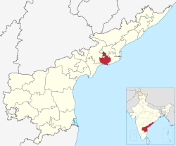 Location of West Godavari district in Andhra Pradesh | |
| Coordinates: 16°07′N 81°01′E | |
| Country | |
| State | |
| Region | Coastal Andhra |
| Headquarters | Bhimavaram |
| Mandals | 19 |
| Government | |
| • District collector | Sri P.Prasanthi (IAS Collector & District Magistrate) |
| • Lok Sabha constituencies | Narsapuram |
| • MP | Raghu Rama Krishna Raju |
| • Assembly constituencies | 07 |
| Area | |
| • Total | 2,178 km2 (841 sq mi) |
| Population (2011) | |
| • Total | 1,779,935 |
| • Density | 820/km2 (2,100/sq mi) |
| Demographics | |
| • Literacy | 74.63% |
| • Sex ratio | 1004 |
| PIN | 534201[1] |
| Vehicle registration | AP-37 (former) AP–39 (from 30 January 2019)[2] |
| Major highways | NH-16, NH-216, NH-216A, NH-365BB, NH-516D, NH-516E |
| Website | westgodavari |

History
The Eastern Chalukyas ruled coastal Andhra Pradesh from 700 to 1200 CE, with their capital in Vengi. Historical evidence of their rule has been found in the nearby villages of Pedavegi and Guntupalli (Jilakarragudem). Eluru then became a part of the Kalinga Empire until 1471 CE before conquest by the Gajapati Empire. In 1515 CE, Sri Krishna Deva Raya captured it. After the fall of the Vijayanagara Kingdom, it was ruled by the Qutb Shahi Dynasty's Sultans of Golkonda.[6] On 15 April 1925, the West Godavari District was formed with Bhimavaram as its headquarters, and all of the district offices and regional offices were centralized in Eluru.[7]
During the Madras Presidency in 1823, the District of Rajahmundry was created.[8] It was reorganized in 1859 and bifurcated into the Godavari and Krishna districts. During British rule, Rajahmundry was the headquarters of Godavari district, which was further bifurcated into the East Godavari and West Godavari districts in 1925.[9] When the Godavari district was divided, Kakinada became the headquarters of East Godavari and Eluru became the headquarters of West Godavari. After the 4 April 2022 bifurcation for a separate Eluru district, Bhimavaram became the new headquarters of the West Godavari district.
Geography
The district occupies an area of 7,742 km2 (2,989 sq mi). The district is bounded by the East Godavari district on the North, Eluru district on the Northwest, Kakinada district on the Southeast, Krishna district on the Southwest. and Bay of Bengal on the south. The Godavari River flows on the east, while the Tammileru River and Kolleru Lake separate it from the Krishna district on the west.[10]: 22
Rivers and topography
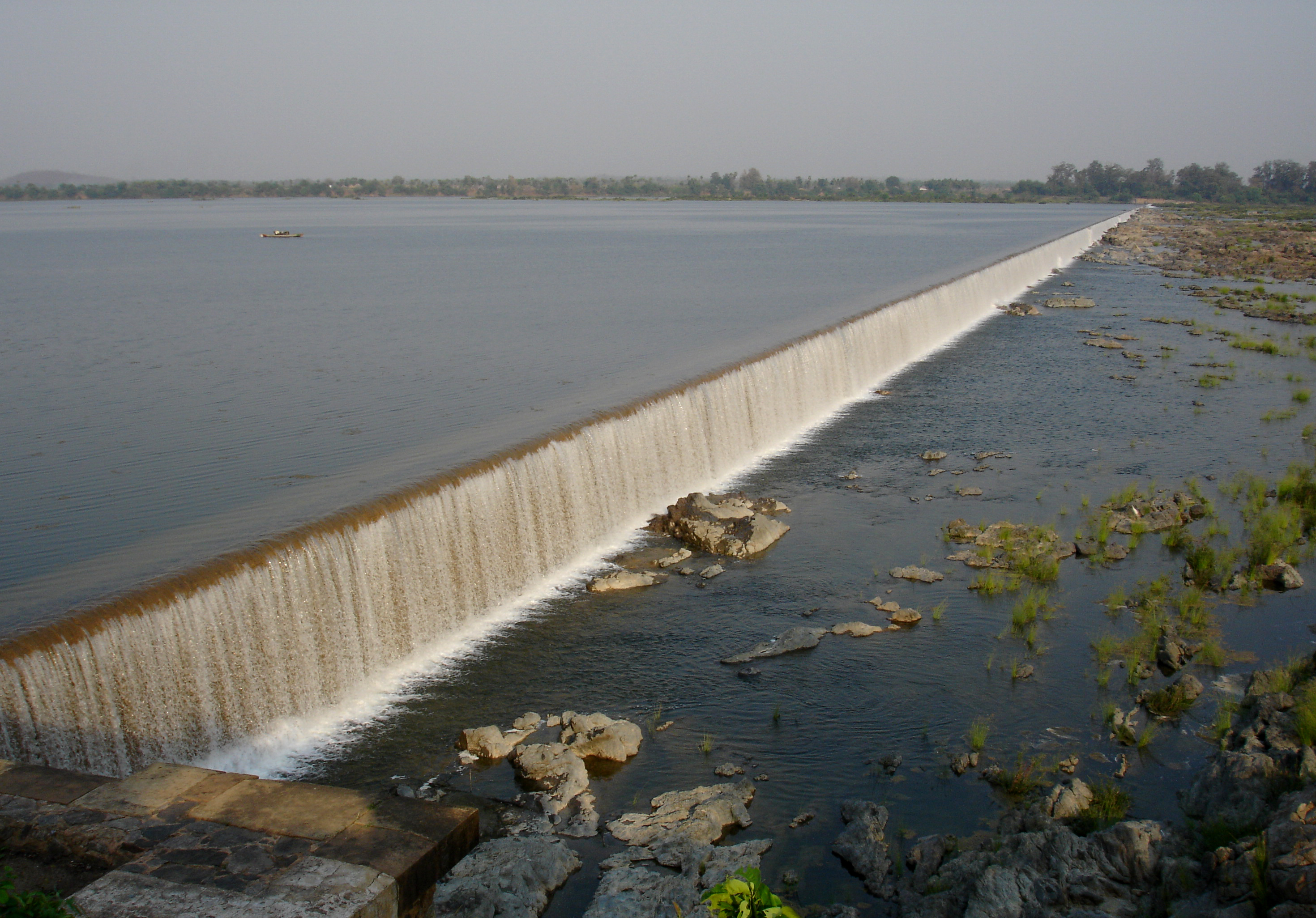
West Godavari is a flat region with a slightly slope along the rivers flowing eastward. The three rivers cutting through the district are the Godavari (after which the district is named), the Yerrakaluva, and the Tammileru. Sir Arthur Cotton Barrage, Eluru Canal, Vijayarai Anicut, Tammileru, Jalleru, and the Yerrakaluva reservoirs are the major sources of irrigation.[11][12]
Climate
The region has a tropical climate similar to the rest of the Coastal Andhra region. The summers (March–June) are very hot and dry, while the winters are much cooler. The temperatures in the summers often rise over 50°C during the day.[citation needed] The rainy season (July–December) is considered the best time for tourist visits, as the fields are bright green with paddy crops, rivers are flowing with monsoon water, and climate is relatively cool. There are several large mensions scattered around the Godavari area that once belonged to zamindars.
Demographics
| Year | Pop. | ±% p.a. |
|---|---|---|
| 1901 | 919,234 | — |
| 1911 | 1,046,050 | +1.30% |
| 1921 | 1,118,436 | +0.67% |
| 1931 | 1,298,758 | +1.51% |
| 1941 | 1,465,111 | +1.21% |
| 1951 | 1,697,727 | +1.48% |
| 1961 | 1,978,257 | +1.54% |
| 1971 | 2,374,306 | +1.84% |
| 1981 | 2,873,958 | +1.93% |
| 1991 | 3,517,568 | +2.04% |
| 2001 | 3,803,517 | +0.78% |
| 2011 | 3,936,966 | +0.35% |
| source:[13] | ||
As of the 2011 Census of India, the West Godavari district has a population of 3,936,966 with 1,091,525 households, which is the 11th most populous district in the state.[10] The district's population is approximately equal to the population of Croatia and the American state of Oklahoma.[14][15]
In Andhra Pradesh, the West Godavari district is the 19th largest in terms of area with an area of 7,742 km2 (2,989 sq mi) (before bifurcation) and has a population density of 509/km2 (1,320/sq mi), which is the fourth-most densely populated district in the state.[10] Its population growth rate between 2001–2011 was 3.45%.[16] West Godavari has a sex ratio of 1004 females for every 1000 males and stands at the eighth position. It has the highest literacy rate among all Andhra Pradesh districts with 26,52,389 (74.63%) literate residents.[10] 20.6% of the district's population lives in urban areas.[17]
After bifurcation, the district had a population of 1,779,935. Scheduled Castes and Scheduled Tribes made up 289,195 (16.25%) and 15,670 (0.88%) of the population respectively.[19]: 81–85 Telugu was the predominant language, spoken by 98.67% of the population.[20]
Economy
The gross district domestic product is ₹45,963 crore (US$5.8 billion) and it contributes 8.8% to the gross state domestic product. For the FY 2013–14, the per capita income at current prices was ₹86,974 (US$1,100).
Paddy, banana, sugarcane, and coconut are the main agricultural products cultivated in the district. The agriculture sector contributes ₹18,385 crore (US$2.3 billion), industries contribute ₹7,086 crore (US$890 million), and services contribute ₹20,491 crore (US$2.6 billion) to the gross district domestic product.[17] The major products contributing to the gross value added of the district from agriculture and allied services are the previously listed agricultural products, as well as milk, meat, and fisheries. The gross value added to the industrial and service sector is contributed from construction, electricity, manufacturing, unorganized trade, and transport.[17]
Cashew nut, mango and tobacco are other important produce from the district.[11] Shrimp production is also a main activity along with fish farming.[21] The woolen pile carpet industry in Eluru produces eco-friendly carpets from exported wool.[22][23]
Culture
Telugu is the most widely spoken language.[21] The Vedas, which have oral heritage recognition by UNESCO, are taught at the Sri Venkateswara Veda Patasala of the district's Bhimavaram village.[24] The district is well known for its wool-pile carpets and hand woven products.[25]
Tourism and landmarks
Eluru is the largest city of the district with many destinations having Buddhists and archeological importance, such as the Guntupalli Caves, one of the top 30 Indian heritage sites, near the city.[26] Eluru hosts a 74-foot high Buddha statue in the heart of the city.
Some of the religious destinations include Dwaraka Tirumala, known by the name of Chinna Tirumala,[27] Veerabhadra Temple, Pattiseema, and Pancharama Kshetras of Palakollu and Bhimavaram.[28] Other tourist destinations of importance are Perupalem Beach at Narasapuram, the Kolleru Lake (the largest fresh water lake in the country and a bird sanctuary),[29] Sir Arthur Cotton Barrage, and Havelock Bridge. The Government of Andhra Pradesh is keen on developing Rajahmundry Airport as an international airport to boost tourism, including helicopter tours over the Godavari districts. The Polavaram Project irrigation system is expected to become another tourist attraction for the district.

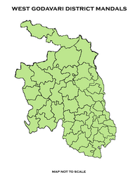
Administrative divisions

The new West Godavari district has two revenue divisions in Bhimavaram and Narasapuram. These revenue divisions divide the district into 19 mandals. These 19 mandals consists of 296 Revenue villages, 0 municipal corporations, and 6 municipalities (Narasapuram, Palakollu, Tadepalligudem, Tanuku, and Bhimavaram, Akiveedu.[10]: 22–23, 54
| # | Bhimavaram Division | Narasapuram Division |
|---|---|---|
| 1 | Attili | Tanuku |
| 2 | Bhimavaram | Iragavaram |
| 3 | Veeravasaram | Penumantra |
| 4 | Palakoderu | Penugonda |
| 5 | Undi | Achanta |
| 6 | Akiveedu | Poduru |
| 7 | Kalla | Yelamanchili |
| 8 | Tadepalligudem | Palakollu |
| 9 | Pentapadu | Naraspuram |
| 10 | Mogalthur |
Parliament Segment
Narasapuram (Lok Sabha constituency)
Assembly Segments
Narasapuram Lok Sabha constituency presently comprises the following Legislative Assembly segments:[30]
| Constituency number | Name | Reserved for (SC/ST/None) |
Parliament |
|---|---|---|---|
| 56 | Achanta | None | Narasapuram Lok Sabha constituency |
| 57 | Palakollu | None | Narasapuram Lok Sabha constituency |
| 58 | Narasapuram | None | Narasapuram Lok Sabha constituency |
| 59 | Bhimavaram | None | Narasapuram Lok Sabha constituency |
| 60 | Undi | None | Narasapuram Lok Sabha constituency |
| 61 | Tanuku | None | Narasapuram Lok Sabha constituency |
| 62 | Tadepalligudem | None | Narasapuram Lok Sabha constituency |
Erstwhile Talukas
Before the formation of mandals, the district was administered through a system of talukas. In 1978, the number of talukas in the West Godavari district increased from 8 to 19. In 1985, the 19 talukas were divided into 46 mandals.
The Andhra Pradesh Reorganisation Act of 2014, merged two mandals from Telangana into the West Godavari District for unified governance over the Polavaram Project, increasing the total mandals to 48.
| S.No. | Erstwhile Talukas
in 1971 |
New Talukas
Formed in 1985 |
New Mandals
Formed in 1985 |
|---|---|---|---|
| 1 | Eluru | Eluru | Eluru, Pedapadu, Pedavegi, |
| Bhimadole [9] | Bhimadole, Dwaraka Tirumala, Denduluru, | ||
| 2 | Chintalapudi | Chintalapudi | Chintalapudi, T.Narsapuram, Lingapuram, Kamavarapukota, |
| 3 | Polavaram | Polavaram | Polavaram, Buttayagudem, jeelugumilli, Koyyalagudem [part], Jangareddygudem [part] |
| 4 | Kovvur | Kovvur | Kovvur, Devarapalli, Chagallu, Nidadavole |
| Gopalapuram [10] | Gopalapuram, Tallapudi, Koyyalagudem [part], Jangareddygudem [part], | ||
| 5 | Tadepalligudem | Tadepalligudem | Tadepalligudem, Nallajerla, Unguturu [part] |
| Ganapavaram [11] | Ganapavaram, Unguturu [part], Nidamarru, Pentapadu, | ||
| 6 | Tanuku | Tanuku | Tanuku, Undrajavaram, Peravali, |
| Penumantra [12] | Penumantra, Penugonda, Atili, Iragavaram, | ||
| 7 | Narsapuram | Narsapuram | Narsapuram, Mogalthooru, Yelamanchili, |
| Poduru [13] | Poduru, Palakollu, Achanta, | ||
| 8 | Bhimavaram | Bhimavaram | Bhimavaram, Palakoderu, Veeravasaram, |
| Akiveedu [14] | Akiveedu, Undi, Kalla |
Cities and towns
Largest cities or towns in West Godavari District As per the 2011 Census | |||||||||
|---|---|---|---|---|---|---|---|---|---|
| Rank | Division | Pop. | |||||||
Bhimavaram |
1 | Bhimavaram | Bhimavaram Division | 146,961 | |||||
| 2 | Tadepalligudem | Bhimavaram Division | 130,348 | ||||||
| 3 | Palakollu | Narasapuram Division | 104,216 | ||||||
| 4 | Tanuku | Narasapuram Division | 77,962 | ||||||
| 5 | Narasapuram | Narasapuram Division | 58,780 | ||||||
| 6 | Akiveedu | Bhimavaram Division | 38,597 | ||||||
| 7 | [[{{{city_7}}}]] | [[{{{div_7}}}]] | {{{pop_7}}} | ||||||
| 8 | [[{{{city_8}}}]] | [[{{{div_8}}}]] | {{{pop_8}}} | ||||||
| 9 | [[{{{city_9}}}]] | [[{{{div_9}}}]] | {{{pop_9}}} | ||||||
| 10 | [[{{{city_10}}}]] | [[{{{div_10}}}]] | {{{pop_10}}} | ||||||
| S.No. | Municipal Body | Civic Status of town | No. of
wards |
Municipality
Formation Year |
2011 Census
Population |
2001 Census
Population |
1991 Census
Population |
1981 Census
Population |
1971 Census
Population |
1961 Census
Population |
1951 Census
Populations |
|---|---|---|---|---|---|---|---|---|---|---|---|
| 1 | Bhimavaram | Municipality Grade - Selection | 39 | 1948 | 1,46,961 | 1,42,064 | 1,21,314 | 1,01,894 | 63,762 | 43,821 | 30,928 |
| 2 | Tadepalligudem | Municipality Grade - Selection | 40 | 1958 | 1,04,032 | 1,02,622 | 88,878 | 62,574 | 43,610 | 27,086 | 13,543 |
| 3 | Palakollu | Municipality Grade - 1 | 35 | 1919 | 81,199 | 76,308 | 56,969 | 46,146 | 36,196 | 28,481 | 23,037 |
| 4 | Tanuku | Municipality Grade - 1 | 34 | 1979 | 77,962 | 72,970 | 62,913 | 53,618 | 34,197 | 24,657 | 16,906 |
| 5 | Narsapuram | Municipality Grade - 1 | 31 | 1956 | 58,770 | 58,604 | 56,362 | 46,033 | 36,147 | 30,064 | 20,999 |
| 6 | Akiveedu | Nagar Panchayat | 20 | 2020 | 36,000 | 24,259 | 29,421 | 21,317 | 16,880 | -- | 10,307 |
Constituencies
There is one parliamentary and seven assembly constituencies in the district. The parliamentary constituency is Narsapuram (Lok Sabha constituency)[31]
The Assembly constituencies are:
- Achanta
- Bhimavaram
- Narsapur
- Palakollu
- Tadepalligudem
- Tanuku
- Undi
Transport
Roadways
The total road length of state highways in the district is 1,229 km (764 mi).[32] The district relies mostly on public transport, such as buses of the Andhra Pradesh State Road Transport Corporation. Most of the major national highways, like NH216 and NH165, pass through towns in the district.
Railways
The South Central Railway division of Indian Railways operates many passenger routes and freight transport through the district. The Howrah-Chennai main line, Vijayawada–Nidadavolu loop line, and Bhimavaram–Narasapuram branch lines are the major lines and sections that provide rail connectivity in the district. The Kovvur-Bhadrachalam Railway line and Kotipalli-Narsapur Railway line are the major railway projects in the district.
Airways
Since the district's Tadepalligudem Airport is not operational, the adjacent Rajahmundry Airport is utilized instead.
Waterways
National Waterway 4 passes through the district and connects Puducherry with Kakinada and Rajahmundry via Tadepalligudem, Eluru. It has access to the Bay of Bengal at Narsapuram. The Andra Pradesh state government began construction of a fishing harbor in Narsapuram in September 2021.[33]
Education
The primary and secondary schools are maintained by the government under the state's School Education Department of the state, supplemented by private institutions.[34][35] According to the school information report for the 2015–16 academic year, there are a total of 4,408 schools. They include 19 government, 2,664 mandal and zilla parishads, 1 residential schools, 1,344 private schools, 3 Kasturba Gandhi Balika Vidyalaya (KGBV), 208 municipal schools, and 169 other types of schools.[36] The total number of students enrolled in primary, upper primary, and high schools within the district was 522,793 during the 2015-16 school year..[37]
Universities
- National Institute of Technology, Tadepalligudem (NIT, Tadepalligudem)
- Dr. Y.S.R. Horticultural University, Venkataramannagudem, Tadepalligudem
Notable people
- Chiranjeevi, film actor, Central Minister
- Prabhas, actor
- Alluri Sitarama Raju, freedom fighter
- Krishnam Raju, film actor, Central Minister
- Ramalinga Raju, founder of Satyam Computer Services
- Trivikram Srinivas, film director
- Sunil (actor), actor
See also
- List of villages in West Godavari district
References
- Pincode List. indiapincodes.net.
- "New 'AP 39' code to register vehicles in Andhra Pradesh launched". The New Indian Express. Vijayawada. 31 January 2019. Retrieved 9 June 2019.
- "History | West Godavari District, Government of Andhra Pradesh | India". Retrieved 25 September 2022.
- "Demography | West Godavari District, Government of Andhra Pradesh | India". Retrieved 25 September 2022.
- "West Godavari". Official portal of Andhra Pradesh Government. Retrieved 13 March 2016.
- "FOCUS: WEST GODAVARI DISTRICT FORMATION DAY". Retrieved 16 August 2017.
- "Ellora – "Encyclopedia". Retrieved 16 August 2017.
- Bhaskar, B. v s (8 June 2014). "Nyapathi Subbarao carved an identity for Telugus". The Hindu – via www.thehindu.com.
- "West Godavari district profile". The Hindu. 15 April 2008. Retrieved 9 June 2015.
- "District Census Handbook – West Godavari" (PDF). Census of India. p. 24. Retrieved 18 January 2015.
- "Ground Water Brochure, West Godavari District, Andhra Pradesh (AAP- 2012–13)" (PDF). Central Ground Water Board. Ministry of Water Resources. p. 7. Retrieved 10 February 2016.
- "IRRIGATION PROFILE WESTGODAVARI DISTRICT".
- Decadal Variation In Population Since 1901
- "Objavljeni konačni rezultati Popisa 2021". template.gov.hr. Retrieved 25 September 2022.
- Bureau, US Census. "Oklahoma Population Up 5.5% Last Decade". Census.gov. Retrieved 25 September 2022.
- "District Census 2011". Census2011.co.in. 2011. Retrieved 30 September 2011.
- "Economy of West Godavari District". Andhra Pradesh Economic Development Board. Retrieved 25 April 2017.
- "Population by Religion - Andhra Pradesh". censusindia.gov.in. Office of the Registrar General & Census Commissioner, India. 2011.
- "District Census Hand Book – West Godavari" (PDF). Census of India. Registrar General and Census Commissioner of India.
- "Table C-16 Population by Mother Tongue: Andhra Pradesh". Census of India. Registrar General and Census Commissioner of India.
- Mannan, M.A (3 January 2013). "Farmers turn away from agriculture to fish farming in Andhra Pradesh". indiatoday.intoday.in. Retrieved 14 March 2016.
- Nagaraja, G (20 March 2014). "Handmade carpet industry in doldrums". The Hindu. Retrieved 26 November 2015.
- Sajnani, Manohar (2001). Encyclopaedia of tourism resources in India. New Delhi: Kalpaz Pub. p. 66. ISBN 978-81-7835-018-9. Retrieved 26 November 2015.
- "President inaugurates TTD's veda patasala in A.P." The Hindu. Akiveedu (West Godavari district). 25 December 2015. Retrieved 14 March 2016.
- Babu, A. Satish (2008). Tourism development in India : a case study. New Delhi: A.P.H.Pub.Corp. p. 87. ISBN 978-81-313-0346-7. Retrieved 16 August 2017.
- "Guntupalli caves are selected as India's top 30 heritage sites".
- "Lord Venkateswara Temple".
- "Someswaralayam in Bhimavaram".
- "Kolleru Lake gets facelift". The Hindu.
- "Delimitation of Parliamentary and Assembly Constituencies Order, 2008" (PDF). The Election Commission of India. p. 30.
- http://ceoandhra.nic.in/Right%20to%20Infn.Act/annex1.htm District-wise Assembly-Constituencies in Andhra Pradesh
- "Existing State Highways" (PDF). Andhra Pradesh Road Development Corporation. Government of Andhra Pradesh. p. 1. Archived from the original (PDF) on 20 September 2018. Retrieved 11 May 2019.
- May 31, Siva G. / TNN / Updated; 2021; Ist, 09:30. "Andhra Pradesh: Narsapuram harbour tender call by September | Visakhapatnam News - Times of India". The Times of India. Retrieved 25 September 2022.
{{cite web}}: CS1 maint: numeric names: authors list (link) - "School Education Department" (PDF). School Education Department, Government of Andhra Pradesh. Retrieved 7 November 2016.
- "The Department of School Education – Official AP State Government Portal". www.ap.gov.in. Retrieved 7 November 2016.
- "School Information Report". Commissionerate of School Education. Government of Andhra Pradesh. Retrieved 8 November 2016.
- "Student Information Report". Commissionerate of School Education. Child info 2015–16, District School Education – Andhra Pradesh. Retrieved 8 November 2016.
External links
Places adjacent to West Godavari district | ||||||||||||||||
|---|---|---|---|---|---|---|---|---|---|---|---|---|---|---|---|---|
| ||||||||||||||||
Capital: Amaravati | |||
| Topics |
| ||
| Regions | |||
| Districts |
| ||
| Million-plus cities | |||
| Cities (population over 1 lakh) |
| ||
| Tourism |
| ||
| History |
| ||
| Related lists |
| ||
| |||
Godavari basin | |||||||||||||||
|---|---|---|---|---|---|---|---|---|---|---|---|---|---|---|---|
| Rivers |
|     | |||||||||||||
| Dams, barrages |
| ||||||||||||||
| Geographical features / regions | |||||||||||||||
| Riparian districts |
| ||||||||||||||
| Cities | |||||||||||||||
| Languages / people | |||||||||||||||
| Coalfields |
| ||||||||||||||
| Oil / gas fields |
| ||||||||||||||
| Industries |
| ||||||||||||||
| Transport |
| ||||||||||||||
| Pollution concerns, River basin's sustainable productivity & ecology |
| ||||||||||||||
| Related topics |
| ||||||||||||||
| Other basins | |||||||||||||||
Authority control | |
|---|---|
| General |
|
| National libraries | |
На других языках
[de] West Godavari
West Godavari (Telugu: పశ్చిమ గోదావరి జిల్లా) ist einer von 13 Distrikten des indischen Bundesstaats Andhra Pradesh. Der Verwaltungssitz ist die Stadt Eluru.- [en] West Godavari district
[ru] Западный Годавари
Западный Годавари (телугу పశ్చిమ గోదావరి జిల్లా; англ. West Godavari) — округ на востоке индийского штата Андхра-Прадеш. Административный центр — город Элуру.Другой контент может иметь иную лицензию. Перед использованием материалов сайта WikiSort.org внимательно изучите правила лицензирования конкретных элементов наполнения сайта.
WikiSort.org - проект по пересортировке и дополнению контента Википедии