world.wikisort.org - India
Vidarbha (Pronunciation: [ʋid̪əɾbʱə]) is a geographical region and a proposed state of central India and is now the eastern region of the Indian state of Maharashtra, comprising Nagpur Division and Amravati Division. Amravati Division's former name is Berar (Varhad in Marathi).[2][3] It occupies 31.6% of the total area and holds 21.3% of the total population of Maharashtra.[1] It borders the state of Madhya Pradesh to the north, Chhattisgarh to the east, Telangana to the south and Marathwada and North Maharashtra regions of Maharashtra to the west. Situated in central India. The largest city in Vidarbha is Nagpur followed by Amravati, Akola, and Chandrapur. A majority of Vidarbhians speak Varhadi and Zadi dialects of Marathi.[4]
Vidarbha | |
|---|---|
Former state and historical region | |
 Dark Blue: Nagpur District, Blue: Nagpur Division, Grey: Amravati District, Sea Green: Amravati Division | |
 Map of India with Vidarbha highlighted in red | |
| Country | India |
| State | Maharashtra |
| Government | |
| • Body | Government of Maharashtra |
| Area | |
| • Total | 97,321 km2 (37,576 sq mi) |
| Population (2011) | |
| • Total | 23,003,179 |
| • Density | 240/km2 (610/sq mi) |
| Demonym | Vaidarbhiya |
| Language | |
| • Official | Marathi |
| Time zone | UTC+5:30 (IST) |
| Vehicle registration | MH- |
| Largest city | Nagpur |
The Nagpur region is known for growing oranges and cotton. Vidarbha holds two-thirds of Maharashtra's mineral resources and three-quarters of its forest resources, and is a net producer of power.[5]
Throughout its history, Vidarbha has remained much calmer than the rest of India, especially during the communal troubles. However, there is considerable poverty[6] and malnutrition.[7] It is less economically prosperous compared to the rest of Maharashtra.[8] The living conditions of farmers in this region are poor compared to India as a whole. There have been more than 200,000 farmers' suicides in Maharashtra in a decade, of which 70% being in the 11 districts of the Vidarbha region.[9]
There have been recent calls for a separate state of Vidarbha, due to perceived neglect from the Government of Maharashtra and incompetent political leadership in Vidarbha. Being politically and financially distinct from the rest of Maharashtra, the calls for a separate state rose to prominence only when the leaders from this region were sidelined by other political leaders in recent years.[10] Statehood demands have not been fulfilled mainly due to the opposition from the Shiv Sena, a major state political party.[11]
History
Ancient period

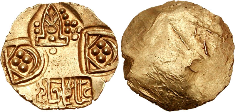
Obv Linear cross with each arm terminating in pellet-in-annulet.
Rev Tree in railing.
Vidarbha was part of the Satavahana Empire/Andhra Empire (1st century BCE - 2nd century CE), as suggested by Satavahana coin finds in Pauni.[12]
Medieval period
Nagpur was the capital of the Berar Subah, known as the Gulshan-e-Berar in the Medieval period, from the rule of the Khaljis to the Mughals, according to the Ain-i-Akbari and Alamgir Namah.[citation needed] In 1724, when Nizam-ul-Mulk Asaf Jah declared independence, the existence of Berar as a Mughal Subah came to an end. It became (though nominally) a part of Hyderabad State ruled by Nizams based in the present-day city of Hyderabad, through the right of collecting chauth were held by Maratha Empire.[13]
Demand for separate statehood
The Vidarbha region is in central India and is currently a part of the Maharashtra state. The Central Provinces legislature unanimously passed a resolution for the creation of the 'Mahavidarbha' state on 1 October 1938 at Nagpur.[citation needed]
Geography


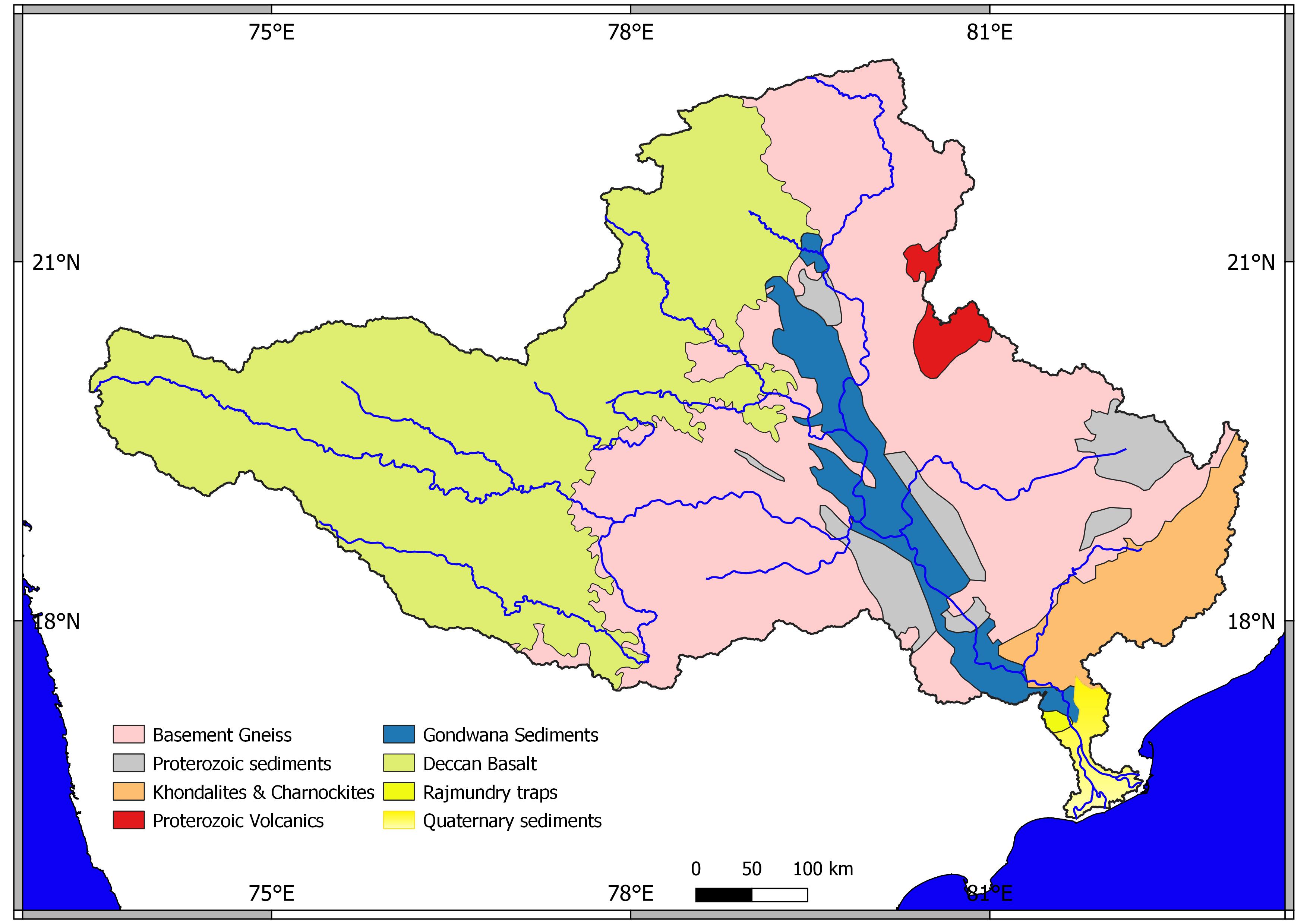
Vidarbha lies on the northern part of the Deccan Plateau. Unlike the Western Ghats, there are no major hilly areas. The Satpura Range lies to the north of Vidarbha region in Madhya Pradesh. The Melghat area of Amravati district is on the southern offshoot of the Satpura Range.[14] Large basaltic rock formations exists throughout Vidarbha, part of the 66-million-year-old volcanic Deccan Traps. Bhandara and Gondia district are entirely occupied by metamorphic rock and alluvium, making their geology unique in Maharashtra.[15]
The Poorna basin
The Poorna basin lies in Western Vidarbha, and gets its name from Poorna river which flows through it. It comprises Akola, Amarawati and Buldhana districts of Vidarbha. The region has extremely high innate soil and water salinity, because of which it is often referred to as "kharpan patta" in Marathi. It means a high soil and water salinity.[16]
Administration
Vidarbha region has 11 districts divided into two divisions (Amravati and Nagpur).
| Name of Division (Headquarter) | Districts | Source |
|---|---|---|
| Amravati Division HQ=Amravati Districts=5 Talukas=56 |
Division Website | |
| Nagpur Division HQ=Nagpur Districts=6 SubDivisions=31 Talukas=64 |
|
Division Website |
Each district has a collector's office which is responsible for day-to-day administration. The District Collector is a Central Indian Government IAS appointee who is in charge of the governance of a district in a state.[17]
Demographics
Vidarbha has a total population of 23,003,179 according to the 2011 India census.[18]
| District | Male | Female | Total |
|---|---|---|---|
| Nagpur | 2,388,558 | 2,264,613 | 4,653,171 |
| Amravati | 1,482,845 | 1,404,981 | 2,887,826 |
| Yavatmal | 1,425,593 | 1,349,864 | 2,775,457 |
| Wardha | 665,925 | 630,232 | 1,296,157 |
| Washim | 621,228 | 575,486 | 1,196,714 |
| Chandrapur | 1,120,316 | 1,073,946 | 2,194,262 |
| Akola | 936,226 | 882,391 | 1,818,617 |
| Bhandara | 604,371 | 594,439 | 1,198,810 |
| Buldhana | 1,342,152 | 1,245,887 | 2,588,039 |
| Gadchiroli | 542,813 | 528,982 | 1,071,795 |
| Gondiya | 662,524 | 659,807 | 1,322,331 |
Religion
Religion in Vidarbha (2011 census)[19]
Religion in Vidarbha is characterized by the diversity of religious beliefs and practices. Vidarbha possesses six of the world's major religions; namely Hinduism, Buddhism, Islam, Jainism, Christianity, and Sikhism.

According to the 2011 census, Hinduism was the principal religion in the state at 76.91% of the total population, while Buddhists constituted 13.08 of the total population. Vidarbha accounts for 45.91% of total Buddhists in Maharashtra.[19]
| Religious composition | Population | Percentage |
|---|---|---|
| Hindus | 15,866,514 | 76.906% |
| Buddhists | 29,98,263 | 13.075% |
| Muslims | 1,720,690 | 8.340% |
| Jains | 89,649 | 0.435% |
| Christians | 70,663 | 0.343% |
| Sikhs | 37,241 | 0.181% |
| Others | 127,516 | 0.618% |
| Religion not stated | 21,170 | 0.103% |
| Total | 23,003,179 | 100% |
Language and culture
Hindu festivals like Holi, Diwali and Dasara are celebrated throughout the region.[20]
As per the 2011 census, 73.72% of the population speaks Marathi, 8.30% Hindi, 6.23% Urdu, 2.58% Lambadi, 1.83% Gondi, 1.10% Korku and 1.02% Telugu as their first language.[21]
The Nagpur Central Museum (est. 1863) maintains collections that are mainly from Vidarbha.[22]
Economy

Nagpur is a hub for business and healthcare. Amravati is known for film distributors and cloth markets. Yavatmal is a cotton city and is an exporter of cotton. Raymond UCO Denim Pvt. Ltd. is situated in Yavatmal. Chandrapur has a thermal power station which is one of the biggest in India and some other heavy industries such as paper (BILT Ballarpur), steel (MEL from Steel Authority of India), cement industries (UltraTech Cement, Ambuja Cements, ACC Limited, Manikgarh Cement, Murli Cement) and numerous coal mines.[23]
MIHAN (Multi-modal International Cargo Hub and Airport at Nagpur) is an international cargo hub.[24][25] MIHAN is for handling heavy cargo coming from South-East Asia and the Middle-East. The project also includes a ₹100 billion (US$1.3 billion) Special Economic Zone (SEZ)[26] for information-technology companies.[27]
Agriculture

Vidarbha has recently gained notoriety for the number of suicides committed by farmers. On 1 July 2006 the Prime Minister of India Manmohan Singh announced a ₹3,750-crore (37.5 billion rupee) relief package for Vidarbha.[28] The package is intended to help farmers in six districts of the region. However the package was not welcomed by most financial pundits and journalist P Sainath wrote in The Hindu that the package was destined to fail. Corruption was found amongst most of the officials involved with the packages and the government considered suspension of more that 400 officials in the scam.[29]
Mineral wealth
Nagpur, Amravati, Yavatmal, Chandrapur, Gadchiroli, Bhandara form the main mineral belt, with coal and manganese as the major minerals. Chandrapur district contributes 29% of all mineral output of Maharashtra.[30] Iron ore and limestone are identified as potential mining resources.[31]
Industry
Nagpur, Amravati, Akola, Yavatmal, Wardha and Chandrapur are Large Industrial center in Vidarbha resp. Ballarpur Industries, India's largest manufacturer and exporter of paper is located in Chandrapur district.[32]
Education
Sports

Cricket is the most popular sport in the region and Nagpur's Vidarbha Cricket Association Ground (VCA) has hosted international cricket matches.[33] It has been superseded by the Vidarbha Cricket Association Stadium,[34] built in 2008 in Jamtha.
Tourism

The eastern region of Vidarbha contains Maharashtra's oldest National Park, the Tadoba Andhari Tiger Reserve,[35] one of India's 39 Project Tiger Reserves.[36] Tipeshwar Wildlife Sanctuary has large number of Tigers. Shegaon is a well known place of pilgrimage attributed to the Hindu Saint Gajanan Maharaj who lived in Shegaon and is worshipped across Maharashtra. Chikhaldara in Amravati district is the only hill station in Vidarbha.
Politics
Representation in Lok Sabha
Vidarbha is represented at the national level by 10 Lok Sabha seats. Nagpur district, which has the highest population density, is split into 2 Lok Sabha seats, Nagpur and Ramtek, while districts with lower population density like Chimur and Gadchiroli are clubbed together. Yavatmal-Washim is one of the most important seats in Vidharbha, as it includes 2 district headquarters. Ramtek and Amravati seats are reserved for Scheduled Caste candidates, while Gadchiroli-Chimur is reserved for Scheduled Tribes.[37]
Representation in Vidhan Sabha
Vidarbha is represented at the state level by 62 Vidhan Sabha seats. Nagpur has the densest concentration of assembly seats with the city divided into 6 areas. Amravati, Akola and Yavatmal are some of the most important seats in Maharashtra. Certain seats are reserved for Scheduled Tribe candidates, while others are open to all. Pusad seat in Yavatmal District is also important as it has given 2 Chief Ministers to Maharashtra.[38]
Separate statehood movement
Politician and economist Dr. Shrikant Jichkar opposed separation of Vidarbha from Maharashtra, believing that it was not sustainable: "If Vidarbha is hived off, we will have no funds from day one to run the new State. The region's share is burdened by a deficit and Monopoly Cotton Purchase Scheme, Employment Guarantee Scheme and such activity will immediately cease since we would not have money to pay salaries." He noted that income from available natural resources could not balance Mumbai's subsidies, and that Mumbai's cooperation was vital to any development—in addition to the societal risks of dividing the Marathi-speaking state.[39]
See also
- Dehani lift irrigation scheme
- List of cities in Vidarbha
- List of Maratha dynasties and states
- Manav Vikas Mission
- Proposed states and territories of India
References
- "Population". 31 March 2011. Retrieved 6 April 2011.
- Asian Review. 1898.
- Journal of the Royal Asiatic Society of Great Britain & Ireland By Royal Asiatic Society of Great Britain and Ireland—page-323
- "Dialects in Maharashtra | Buzzalive". Archived from the original on 23 June 2018. Retrieved 13 April 2017.
- "Nagpur (Urban) pincode - sindhindia".
- "Vidarbha profile on rediff". In.rediff.com. 12 October 2004. Retrieved 22 September 2010.
- "WHO declares Melghat as India's most malnutrition-hit area". Archived from the original on 30 August 2007.
- Sanjiv Phansalkar. "PM 2003 Schedule Irr Pov". IWMI-TATA Water Policy Research Program. Archived from the original on 18 December 2007. Retrieved 6 September 2007.
- "Opinion / News Analysis : Maharashtra: 'graveyard of farmers'". The Hindu. Chennai, India. 14 November 2007. Archived from the original on 16 November 2007.
- "Interview of Maharashtra Pradesh Congress Committee President-Mr. Ranjeet Deshmukh". Rediff.com. 18 August 2004. Retrieved 22 September 2010.
- "Very few takers for a separate State". The Hindu. Chennai, India. 23 March 2004. Archived from the original on 23 June 2004. Retrieved 22 September 2010.
- Sarma, Inguva Karthikeya (1980). Coinage of the Satavahana Empire. Agam. p. 38.
The latest site which contributed valuable numismatic evidence confirming, once and for all, ancient Vidarbha's early Satavahana affiliation is Pauni, in district Bhandara
- Imperial Gazetteer of India, v. 7, p. 369
- "New Page 2". amravati.gov.in. Archived from the original on 30 August 2008.
- "Gondia geology". Gondia.gov.in. Retrieved 22 September 2010.
- Kher, Vivek. "Social and Economic Issues in the Salinity Affected Areas in Poorna Basin: An overview" (PDF). Retrieved 8 September 2022.
- Districts Of Maharashtra Archived 12 January 2008 at the Wayback Machine
- "Vidarbha population 2011".
- "Population by religious community - 2011". 2011 Census of India. Office of the Registrar General & Census Commissioner. Archived from the original on 25 August 2015. Retrieved 25 August 2015.
- "People And Their Culture". Gadchiroli.gov.in. Archived from the original on 21 July 2011. Retrieved 22 September 2010.
- 2011 Census of India, Population By Mother Tongue
- Nagpur District Gazetteer Archived 22 April 2008 at the Wayback Machine
- "Nagpur – Growth Nucleus of India". economictimes.indiatimes.com. 24 December 2008.
- "Maharashtra Airport Development Company Limited". madcindia.org. madcindia.org. Archived from the original on 10 May 2008. Retrieved 14 May 2008.
- "Maharashtra Airport Development Company Limited" (PDF). Press Information Bureau and Ministry of Civil Aviation. Retrieved 29 January 2008.
- "Nagpur stakes claim to lead boomtown pack". The Indian Express. Archived from the original on 29 September 2007. Retrieved 1 June 2006.
- "Mihan is biggest development". The Times of India. 22 May 2007. Archived from the original on 14 March 2012. Retrieved 22 May 2007.
- relief package for Vidarbha
- Sainath, P (16 July 2006). "Politics of packages, packaging of politics". Indiatogether.org. Retrieved 22 September 2010.
- "Demography". Chanda.nic.in. Archived from the original on 3 October 2011. Retrieved 22 September 2010.
- "Maharashtra Resources" Archived 30 September 2007 at the Wayback Machine
- "Ballarpur Industries Limited- Bilt". Chanda.nic.in. Archived from the original on 3 October 2011. Retrieved 22 September 2010.
- "Vidarbha Cricket Association Ground profile". Cricinfo. Retrieved 12 November 2012.
- "Vidarbha Cricket Association Stadiumprofile". Cricinfo. Retrieved 12 November 2012.
- "Tadoba Tiger Reserve". Projecttiger.nic.in. Archived from the original on 24 February 2012. Retrieved 22 September 2010.
- "Online Map". Projecttiger.nic.in. Archived from the original on 5 January 2011. Retrieved 22 September 2010.
- "Archived copy". Archived from the original on 11 July 2007. Retrieved 21 January 2008.
{{cite web}}: CS1 maint: archived copy as title (link) - "Archived copy". Archived from the original on 4 March 2009. Retrieved 21 January 2008.
{{cite web}}: CS1 maint: archived copy as title (link) - "Vidarbha not viable economically". The Hindu. 9 September 2000. Archived from the original on 7 January 2016.
External links
- Article regarding environment of Vidarbha by Dr. Heda
- Tigertrails
- National Park In Vidarbha
- Chisholm, Hugh, ed. (1911). . Encyclopædia Britannica. Vol. 3 (11th ed.). Cambridge University Press. p. 763. This details the history of the province up to 1903, and itself cites Imperial Gazetteer of India (Oxford, 1908)
| Topics |
| ||||||||||||
|---|---|---|---|---|---|---|---|---|---|---|---|---|---|
| Regions |
| ||||||||||||
| Divisions and Districts |
| ||||||||||||
| Million-plus cities in Maharashtra |
| ||||||||||||
| Other cities with municipal corporations | |||||||||||||
Portal:India | |||||||||||||
| Districts of Vidarbha | |
|---|---|
| Cities with municipal corporations | |
Portal:India | |
Godavari basin | |||||||||||||||
|---|---|---|---|---|---|---|---|---|---|---|---|---|---|---|---|
| Rivers |
|     | |||||||||||||
| Dams, barrages |
| ||||||||||||||
| Geographical features / regions | |||||||||||||||
| Riparian districts |
| ||||||||||||||
| Cities | |||||||||||||||
| Languages / people | |||||||||||||||
| Coalfields |
| ||||||||||||||
| Oil / gas fields |
| ||||||||||||||
| Industries |
| ||||||||||||||
| Transport |
| ||||||||||||||
| Pollution concerns, River basin's sustainable productivity & ecology |
| ||||||||||||||
| Related topics |
| ||||||||||||||
| Other basins | |||||||||||||||
| Proposed states |
|  |
|---|---|---|
| Proposed union territories |
| |
Current states and union territories of India | ||
Другой контент может иметь иную лицензию. Перед использованием материалов сайта WikiSort.org внимательно изучите правила лицензирования конкретных элементов наполнения сайта.
WikiSort.org - проект по пересортировке и дополнению контента Википедии