world.wikisort.org - India
Aurangabad division is one of the six administrative divisions of Maharashtra state in India. It represents the Marathwada region of Maharashtra.
Aurangabad Division
Marathwada | |
|---|---|
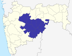 Location of Aurangabad division in Maharashtra | |
| Coordinates: 19°53′19.63″N 75°20′36.37″E | |
| Country | India |
| State | Maharashtra |
| Districts | 1. Aurangabad (Sambhaji Nagar), 2. Nanded, 3. Jalna, 4. Osmanabad, 5. Latur, 6. Beed, 7. Parbhani, 8. Hingoli |
| Government | |
| • Commissioner Aurangabad Division | NA |
| • Police Commissioner Aurangabad Division | NA |
| • All Guardian Minister Aurangabad Division |
|
| • All District Collector's Aurangabad Division |
|
| • All MP's Aurangabad Division | NA |
| Area | |
| • Total | 64,590.58 km2 (24,938.56 sq mi) |
| Population (2011)[1] | |
| • Total | 18,731,872 |
| Languages[2] | |
| • Language | Marathi(official) Urdu Hindi Lambadi |
| Literacy | 76.49%[1] |
Districts
- Aurangabad
- Beed
- Jalna
- Latur
- Hingoli
- Parbhani
- Osmanabad
- Nanded
References
- "District wise Demography". Census 2011. Retrieved 23 May 2015.
- "Aurangabad division languages(Marathwada region)". www.censusindia.gov.in. Census of India 2011.
| Topics |
| ||||||||||||
|---|---|---|---|---|---|---|---|---|---|---|---|---|---|
| Regions |
| ||||||||||||
| Divisions and Districts |
| ||||||||||||
| Million-plus cities in Maharashtra |
| ||||||||||||
| Other cities with municipal corporations | |||||||||||||
Portal:India | |||||||||||||
This article about a location in the Indian state of Maharashtra is a stub. You can help Wikipedia by expanding it. |
This Aurangabad district, Maharashtra, India location article is a stub. You can help Wikipedia by expanding it. |
На других языках
[de] Aurangabad (Division)
Aurangabad ist eine Division im indischen Bundesstaat Maharashtra. Ihr Gebiet ist nahezu identisch mit dem der historischen Region Marathwada.- [en] Aurangabad division
Текст в блоке "Читать" взят с сайта "Википедия" и доступен по лицензии Creative Commons Attribution-ShareAlike; в отдельных случаях могут действовать дополнительные условия.
Другой контент может иметь иную лицензию. Перед использованием материалов сайта WikiSort.org внимательно изучите правила лицензирования конкретных элементов наполнения сайта.
Другой контент может иметь иную лицензию. Перед использованием материалов сайта WikiSort.org внимательно изучите правила лицензирования конкретных элементов наполнения сайта.
2019-2026
WikiSort.org - проект по пересортировке и дополнению контента Википедии
WikiSort.org - проект по пересортировке и дополнению контента Википедии