world.wikisort.org - India
Nashik district, also known as Nasik district, is a district in Maharashtra, India. The city of Nashik is the administrative headquarters of the district. Nashik is well known for the production of wine. Nashik is also known as Mini Maharashtra, because the climate and soil conditions of Surgana, Peth, Igatpuri resembles with Konkan. Niphad, Sinnar, Dindori, Baglan blocks are like Western Maharashtra and Yeola, Nandgaon, Chandwad blocks are like Vidarbha Region. Nashik is the biggest city in the district while Malegaon is the second biggest city. Manmad, Igatpuri, sinnar are some of the big cities situated in the Nashik District. Manmad is one of the biggest railway junction in india while the city of Malegaon is famous for its powerloom.
Nashik district | |
|---|---|
District of Maharashtra | |
     | |
 Location in Maharashtra | |
 Nashik district | |
| Country | |
| State | Maharashtra |
| Division | Nashik |
| Established | 1869[1] |
| Headquarters | Nashik |
| Tehsils | 1. Nashik, 2. Sinnar, 3. Igatpuri, 4. Trimbak, 5. Niphad, 6. Yeola, 7. Peth, 8. Dindori, 9. Chandwad, 10. Baglan, 11. Deola, 12. Kalwan, 13. Malegaon, 14. Nandgaon, 15. Surgana |
| Government | |
| • Type | Zilla Parishad |
| • Body | Sangli Zilla Parishad |
| • Guardian Minister | Dadaji Bhuse (Cabinet Minister MH) |
| • President Zilla Parishad |
|
| • District Collector | Mr. Gangatharan D. IAS |
| • CEO Zilla Parisha | NA |
| • MPs | Hemant Godse (Nashik) Dr. Bharati Pawar (Dhule) |
| Area | |
| • Total | 15,582 km2 (6,016 sq mi) |
| Population (2011) | |
| • Total | 6,107,187 |
| • Rank | 8th (In India), 3rd(In Maharashtra) |
| • Density | 390/km2 (1,000/sq mi) |
| • Urban | 58.67% |
| Demographics | |
| • Literacy | 80.96% [2] |
| • Sex ratio | 931 ♀ / 1000 ♂[3] |
| Time zone | UTC+05:30 (IST) |
| Vehicle registration | MH15(Nashik city) MH41(Malegaon) |
| Major highways | NH-3, NH-50 |
| Website | nashik |
Nashik district is the third largest district in Maharashtra state in terms of population of 8,107,187 and occupying an area of 15,582 square kilometres in the north Maharashtra region. It is bounded by Dhule District to the north, Jalgaon District to the east, Aurangabad District to the southeast, Ahmadnagar District to the south, Thane District to the southwest, Valsad and Navsari districts of Gujarat to the west, and The Dangs district of Gujarat state to the northwest.
The Western Ghats or Sahyadri range stretches from north to south across the western portion of the district. With the exception of the westernmost few villages, the western portion is hilly, and intersected by ravines, and only the simplest kind of cultivation is possible. The western slope of the Ghats is drained by several rivers, including the Daman Ganga River, which drains westwards to the Arabian Sea.
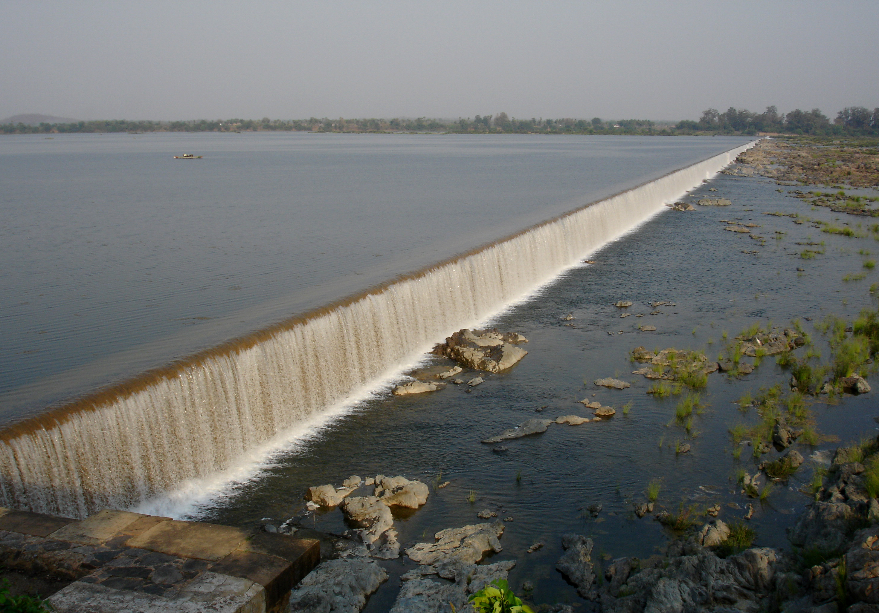
The larger eastern portion of the district, which lies on the Deccan Plateau, is open, fertile, and well cultivated. The Satmala-Chandwad Range, which runs east and west, forms the chief divide of the plateau region. Peninsular India's largest river Godavari originates in the district in the Trimbakeshwar Range and continues eastwards through the district.[4] The Satmala-Chandwad Range forms a watershed, such that, the rivers emerging to its south drain into the Godavari. These include the Kadva and Darna both of which are tributaries of the Godavari. To the north of the Satmala-Chandwad Range, the Girna River and its tributary, the Mosam, flow eastward through fertile valleys into the Tapti River.
The Trimbakeshwar Shiva Temple is located in Trimbak, one of the twelve Jyotirlingas, where a set of Hindu genealogy registers at Trimbakeshwar are maintained. The origin of the sacred Godavari river is at Brahmagiri peak near Trimbak.
Officer
Members of Parliament
- Hemant Godse (BSS)
(Nashik) - Dr. Bharati Pawar (BJP)
(Dindori) - Dr. Subhash Bhamre (BJP)
(Dhule)
Guardian Minister
| Guardian Minister Nashik | |
|---|---|
| पालकमंत्री नाशिक | |
 Emblem of India | |
Incumbent Dadaji Bhuse since 24 September 2022 | |
| Style | The Honourable |
| Appointer | Chief Minister of Maharashtra |
| Term length | 5 years / No time limit |
| Website | nashik |
list of Guardian Minister
| Name | Term of office |
|---|---|
| Girish Bapat | 31 October 2014 - 23 May 2019 |
| Pankaja Munde Additional Charge | 23 May 2019 - 8 November 2019 |
| Chhagan Bhujbal | 9 January 2020 - 29 June 2022 |
| Dadaji Bhuse | 24 September 2022 - Incumbent |
District Magistrate/Collector
| District Magistrate / Collector Nashik | |
|---|---|
| जिल्हाधिकारी तथा जिल्हदंडाधिकरी नाशिक | |
Emblem of India | |
Incumbent Mr. Gangatharan D. (IAS) since 2018 | |
| Residence | At Nashik district |
| Appointer | Government of Maharashtra |
| Term length | No time limit |
| Website | nashik |
list of District Magistrate / Collector
| Name | Term of office |
|---|---|
| Mr. Gangatharan D. (IAS) | 2018 - Incumbent |
History
In the 18th century, the present-day Nashik district was part of the Maratha Confederacy, within the territory controlled directly by the Maratha Peshwa. The district contains several old hill forts, the scenes of many engagements during the Anglo-Maratha Wars. The district became British territory in 1818 on the overthrow of the Peshwa. The present-day district was initially divided between Kandesh and Ahmadnagar districts of Bombay Presidency, a province of British India. Nashik district was created in 1869. The population in 1901 was 816,504, showing a decrease of 3% in the decade 1891–1901. The principal crops were millet, wheat, pulse, oil-seeds, cotton and sugar cane. There were also some vineyards, and much garden cultivation. Yeola was an important centre for weaving silk and cotton goods. There were flour-mills at Malegaon, railway workshops at Manmad and Igatpuri, and cantonments at Deolali and Malegaon. At Sharanpur was a Christian village, with an orphanage of the Church Missionary Society, founded in 1854. In 1861 the main northeast line of the Great Indian Peninsula Railway was completed across the district, and in 1878 a chord line was completed between Manmad, on the northeast line in Nashik district, and Daund, on the southeast line in Pune district. From India's independence in 1947 up to 1960, Nashik district was part of Bombay State, which split into the states of Maharashtra and Gujarat.
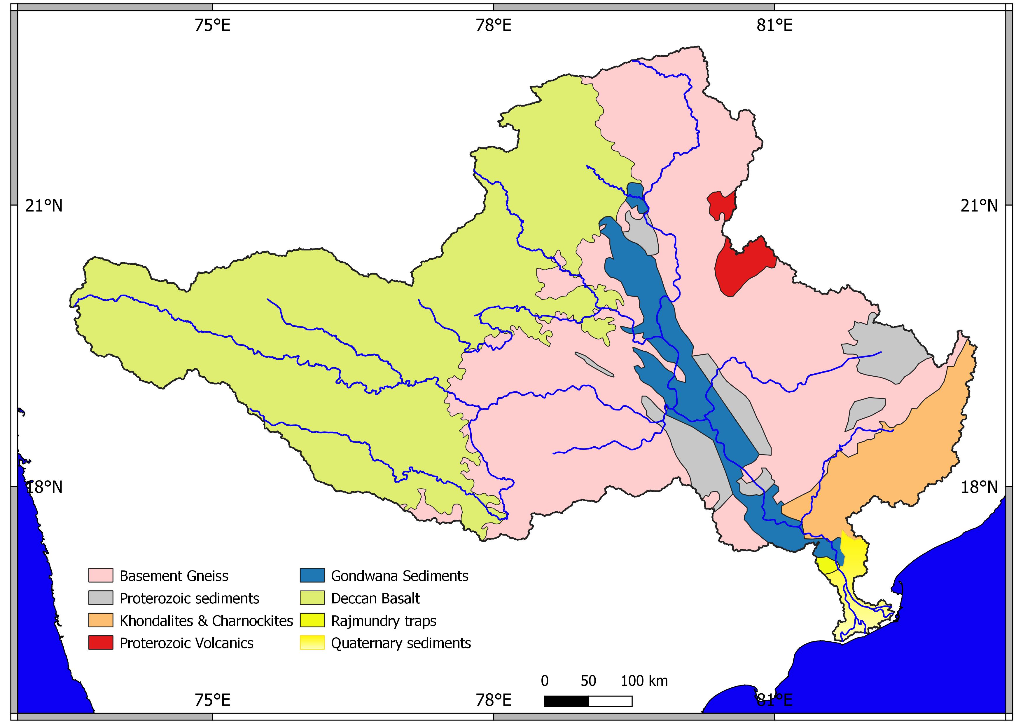
Geology

The entire Nashik district is underlain by the basaltic lava flows. These flows are normally horizontally disposed over a wide stretch and give rise to table land type of topography also known as a plateau. These flows occur in layered sequences and represented by massive unit at the bottom and vesicular unit at the top of the flow. The shallow alluvial formation of recent age also occurs as narrow stretch along the banks of Godavari Rivers. The soils are the weathering products of Basalt and have various shades from gray to black, red and pink colour.[5]
Geography
Nashik District is a noted for the mountains and hills occupying the north and north-east of its territory. These hill ranges are eastward spurs of the Western Ghats and form prominent landmarks in the district, some noted for the shrines they harbor while others for the trekking adventures which can be undertaken while ascending the peaks. Broadly categorized, the hills can be segregated into 3 noteworthy ranges:
- Selbari Range which may be inclusive of the Dholbari range, alternately called Selbari-Dholbari range.
- Satmala Range also called the Satmala-Ajanta range.
- Trimbakeshwar Range constituting the Trimbak-Anjaneri hills.
Climate
Extremes: max 42.4 °C (108.3 °F) on May 12, 1960, at Nasik. The lowest, also at Nasik, was 0.6 °C (33.1 °F) on January 7, 1945.[6]
| Climate data for Nashik district | |||||||||||||
|---|---|---|---|---|---|---|---|---|---|---|---|---|---|
| Month | Jan | Feb | Mar | Apr | May | Jun | Jul | Aug | Sep | Oct | Nov | Dec | Year |
| Average high °C (°F) | 29 (84) |
31 (88) |
35 (95) |
37 (99) |
37 (99) |
32 (90) |
28 (82) |
27 (81) |
29 (84) |
32 (90) |
31 (88) |
29 (84) |
31 (88) |
| Average low °C (°F) | 10 (50) |
12 (54) |
16 (61) |
20 (68) |
22 (72) |
23 (73) |
22 (72) |
21 (70) |
21 (70) |
18 (64) |
14 (57) |
12 (54) |
18 (64) |
| Average precipitation mm (inches) | 1.2 (0.05) |
0.5 (0.02) |
1.0 (0.04) |
4.7 (0.19) |
15.1 (0.59) |
154.9 (6.10) |
315.0 (12.40) |
259.0 (10.20) |
183.3 (7.22) |
68.0 (2.68) |
22.3 (0.88) |
4.6 (0.18) |
1,029.6 (40.55) |
| Source 1: wunderground.com[7] | |||||||||||||
| Source 2: data.gov.in[8] | |||||||||||||
Demographics
| Year | Pop. | ±% p.a. |
|---|---|---|
| 1901 | 823,080 | — |
| 1911 | 915,698 | +1.07% |
| 1921 | 845,783 | −0.79% |
| 1931 | 1,009,583 | +1.79% |
| 1941 | 1,127,597 | +1.11% |
| 1951 | 1,429,916 | +2.40% |
| 1961 | 1,855,246 | +2.64% |
| 1971 | 2,369,221 | +2.48% |
| 1981 | 2,991,739 | +2.36% |
| 1991 | 3,851,352 | +2.56% |
| 2001 | 4,993,796 | +2.63% |
| 2011 | 6,107,187 | +2.03% |
| source:[9] | ||
According to the 2011 census Nashik district has a population of 6,107,187,[10] roughly equal to the nation of El Salvador[11] or the US state of Missouri.[12] This gives it a ranking of 11th in India (out of a total of 640).[10] The district has a population density of 393 inhabitants per square kilometre (1,020/sq mi) .[10] Its population growth rate over the decade 2001-2011 was 22.33%.[10] Nashik has a sex ratio of 931 females for every 1000 males,[10] and a literacy rate of 80.96%. Scheduled Castes and Scheduled Tribes make up 9.08% and 25.62% of the population respectively.[10]
The district is 75.64% urban as of 2007.[13]
Languages
At the time of the 2011 Census of India, 72.42% of the population in the district spoke Marathi, 8.56% Urdu, 5.74% Khandeshi, 5.15% Hindi, 2.44% Bhili and 1.41% Kukna as their first language.[15]
Marathi is the official and main language spoken. Various dialects are spoken in smaller parts of northern district that include Ahirani and Bhili.[16] With religious places like Nashik, Trimbakeshwar, ancient Indian language Sanskrit is spoken and widely understood.
Divisions
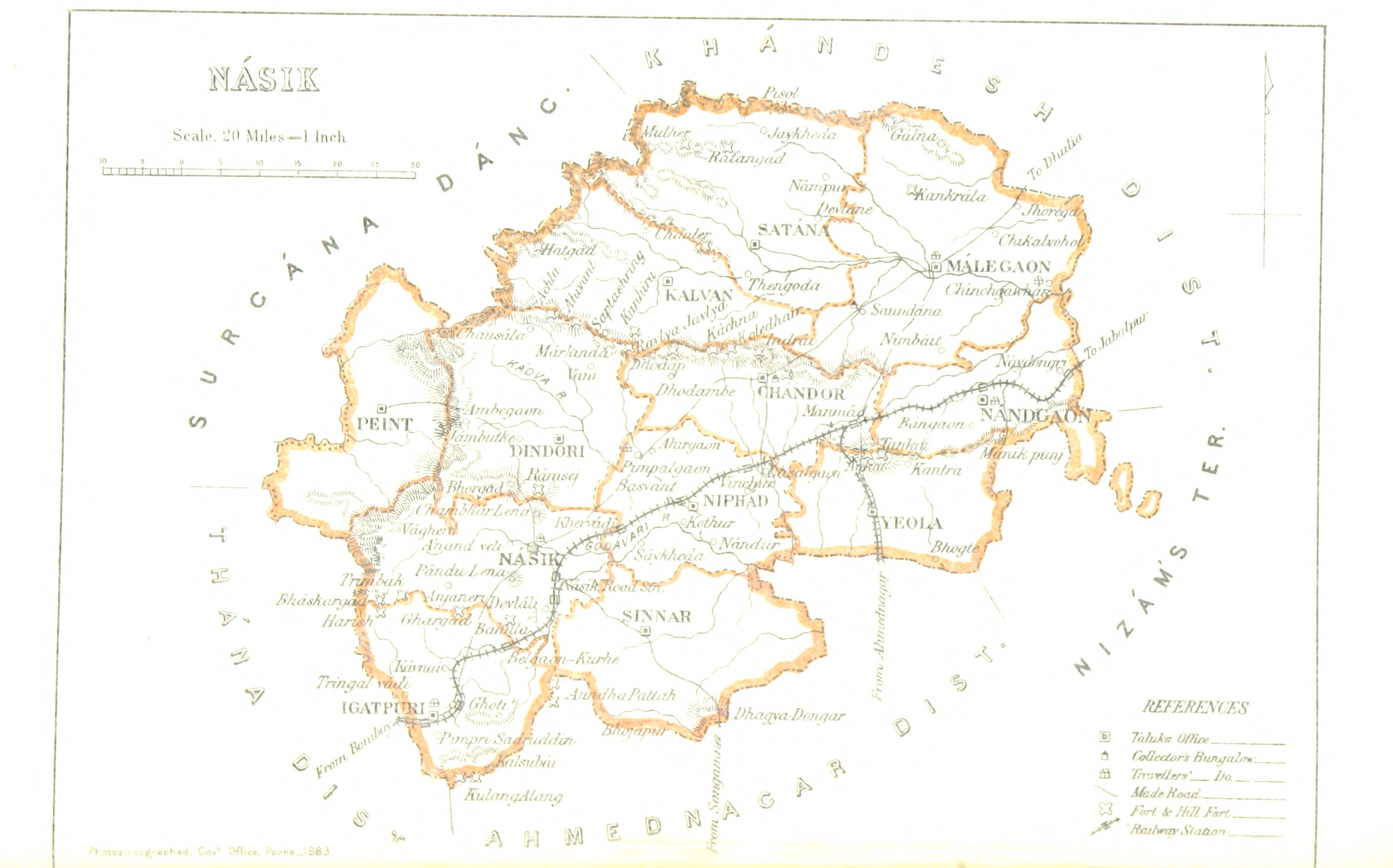
Administratively, the district is divided into fifteen talukas, which are grouped into four sub-divisions:
- Nashik sub-division: Dindori, Igatpuri, Nashik, Nashik Road, Peth, Trimbakeshwar,
- Malegaon sub-division: Chandwad, Malegaon, Nandgaon
- Niphad sub-division: Niphad, Sinnar, Yeola
- Kalwan sub-division, Deola, Kalwan, Baglan (Satana), Surgana
- The Nashik district is under proposal to be bifurcated and a separate Malegaon District be carved out of existing Nashik district with the inclusion of the north eastern parts of Nashik district which include Malegaon, Nandgaon, Deola, Baglan, and Kalwan talukas in the proposed Malegaon district.
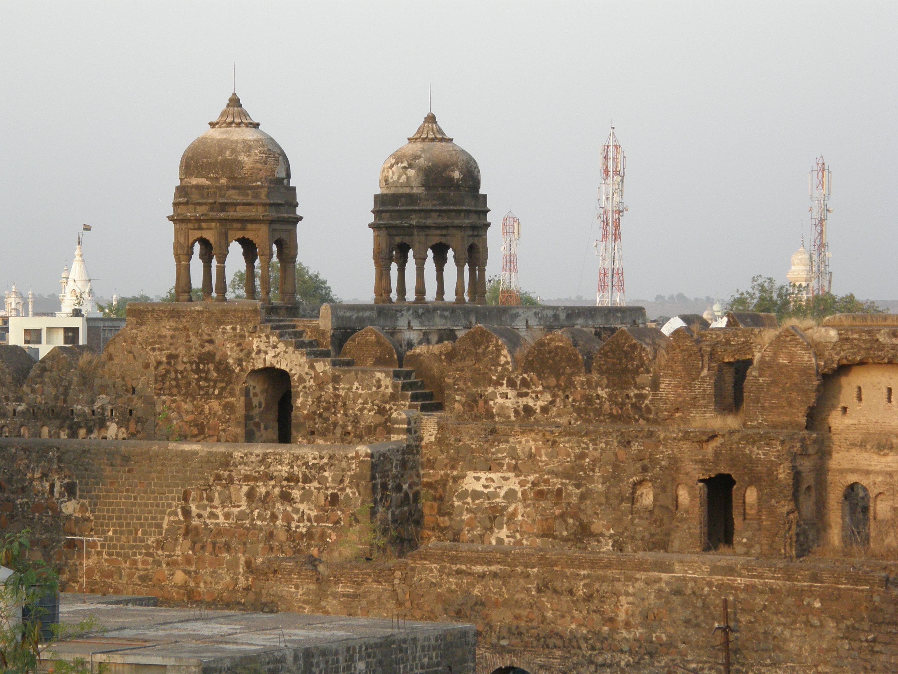
Places of interest
The Nashik-Trimbakeshwar Simhastha (Kumbha Mela) is held after every twelve years at Nashik.
- Malegaon
- Galna
- Trimbakeshwar One of the twelve Jyotirlingas
- Vani or SaptaShrungi
- Muktidham
- Kalaram Temple
- Ozar
- Kalsubai
- Chandwad
- Someshwar
- Gondeshwar Temple, Sinnar
- Mangi Tungi
- Devlali
- Manmad
- Ankai Fort
- Yeola
- Sula Vineyards
See also
- Koli rebellions
- List of Koli people
- List of Koli states and clans
Notes
- "Nashik District was established by British Government". nashik.gov.in. Retrieved 16 August 2021.
- "Nashik District record literacy rate".
- "Nashik District record of sex ratio".
- Chisholm, Hugh, ed. (1911). . Encyclopædia Britannica. Vol. 19 (11th ed.). Cambridge University Press. pp. 247–248.
- Deshpande S.M.and Aher K.R.'Quality of Groundwater from Tribakeswar-Peth area of Nashik District and its Suitability for Domestic and Irrigation Purpose', Gondwana Geological Magazine,26(2),2011 ISSN 0970-261X.
- "सर्व्हर दोष !". Maharashtra.gov.in. Retrieved 2022-08-11.
- "Historical Weather for Delhi, India". Weather Underground. June 2011. Retrieved November 27, 2008.
- "District Rainfall Normal (in mm) Monthly, Seasonal And Annual : Data Period 1951-2000". Government of India. Retrieved November 5, 2014.
- Decadal Variation In Population Since 1901
- "District Census 2011 - Nashik" (PDF). Office of the Registrar General, India. 2011.
- US Directorate of Intelligence. "Country Comparison:Population". Archived from the original on June 13, 2007. Retrieved 2011-10-01.
El Salvador 6,071,774 July 2011 est.
- "2010 Resident Population Data". U. S. Census Bureau. Retrieved 2011-09-30.
Missouri 5,988,927
- "Census GIS India". Archived from the original on 2007-07-03. Retrieved 2010-11-20.
- "C-16 Population By Religion - Maharashtra". census.gov.in.
- 2011 Census of India, Population By Mother Tongue
- M. Paul Lewis, ed. (2009). "Ahirani: A language of India". Ethnologue: Languages of the World (16th ed.). Dallas, Texas: SIL International. Retrieved 2011-09-28.
Chandwad
References
- Hunter, William Wilson, Sir, et al. (1908). Imperial Gazetteer of India, Volume 18, pp 398–409. 1908–1931; Clarendon Press, Oxford.
External links
Places adjacent to Nashik district | ||||||||||||||||
|---|---|---|---|---|---|---|---|---|---|---|---|---|---|---|---|---|
| ||||||||||||||||
| Topics |
| ||||||||||||
|---|---|---|---|---|---|---|---|---|---|---|---|---|---|
| Regions |
| ||||||||||||
| Divisions and Districts |
| ||||||||||||
| Million-plus cities in Maharashtra |
| ||||||||||||
| Other cities with municipal corporations | |||||||||||||
Portal:India | |||||||||||||
Nashik district topics | ||
|---|---|---|
| Cities and towns |  | |
| Villages |
| |
| Rivers and lakes | ||
| Education |
| |
| Lok Sabha constituencies |
| |
| Vidhan Sabha constituencies |
| |
| Major Highways |
| |
Godavari basin | |||||||||||||||
|---|---|---|---|---|---|---|---|---|---|---|---|---|---|---|---|
| Rivers |
|     | |||||||||||||
| Dams, barrages |
| ||||||||||||||
| Geographical features / regions | |||||||||||||||
| Riparian districts |
| ||||||||||||||
| Cities | |||||||||||||||
| Languages / people | |||||||||||||||
| Coalfields |
| ||||||||||||||
| Oil / gas fields |
| ||||||||||||||
| Industries |
| ||||||||||||||
| Transport |
| ||||||||||||||
| Pollution concerns, River basin's sustainable productivity & ecology |
| ||||||||||||||
| Related topics |
| ||||||||||||||
| Other basins | |||||||||||||||
На других языках
[de] Nashik (Distrikt)
Der Distrikt Nashik (Marathi: .mw-parser-output .Deva{font-size:120%}@media all and (min-width:800px){.mw-parser-output .Deva{font-size:calc(120% - ((100vw - 800px)/80))}}@media all and (min-width:1000px){.mw-parser-output .Deva{font-size:100%}}नाशिक जिल्हा) ist einer von 35 Distrikten des Staates Maharashtra in Indien.- [en] Nashik district
[ru] Насик (округ)
На́сик (маратх. नाशिक जिल्हा; англ. Nashik) или На́шик (англ. Nasik) — округ в индийском штате Махараштра. Образован 1 мая 1960 года. Административный центр — город Насик. Площадь округа — 15 530 км². По данным всеиндийской переписи 2001 года население округа составляло 4 993 796 человек. Уровень грамотности взрослого населения составлял 74,4 %, что выше среднеиндийского уровня (59,5 %). Доля городского населения составляла 38,8 %. В округе Нашик расположено одно из важнейших мест паломничества шиваитов — Тримбакешвар.Другой контент может иметь иную лицензию. Перед использованием материалов сайта WikiSort.org внимательно изучите правила лицензирования конкретных элементов наполнения сайта.
WikiSort.org - проект по пересортировке и дополнению контента Википедии