world.wikisort.org - India
Sangareddy district, is a district in the Indian state of Telangana. This district contains a part of the Hyderabad Metropolitan Region.[2] The district shares boundaries with Medak, Medchal, Vikarabad, Kamareddy and Rangareddy districts and with the state boundary of Karnataka.
Sangareddy district | |
|---|---|
District of Telangana | |
 Ramalingeshwara temple, Nandikandi | |
 Sangareddy district Location in Telangana | |
| Coordinates (Sangareddy): 17.780532, 77.892057 | |
| Country | |
| State | Telangana |
| Mandals | 26 |
| Established | 11 October 2016[1] |
| Founded by | Government of Telangana, |
| Headquarters | Sangareddy |
| Revenue Divisions | 04
|
| Government | |
| • Type | Zilla Panchayath |
| • Body | Sangareddy Zilla Panchayath |
| • Collector | M. Hanumantha Rao, IAS |
| Area | |
| • Total | 4,996.46 km2 (1,929.14 sq mi) |
| Population (2015) | |
| • Total | 1,607,244 |
| • Density | 378.5/km2 (980/sq mi) |
| Time zone | UTC+05:30 (IST) |
| Vehicle registration | TS 15 |
| Major highways |
|
| Website | sangareddy |
Geography
The district is spread over an area of 4,464.87 square kilometres (1,723.90 sq mi).[3]
Demographics
As of 2011[update] Census of India, the district has a population of 1,495,503. Scheduled Castes and Scheduled Tribes are 17.96% and 5.70% of the population respectively.[4]
Hindus are 81.44% while Muslims are 16.15% and Christians are 1.56% of the population.[5]
Language
Administrative divisions
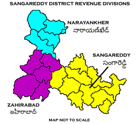
The district has four revenue divisions of Narayankhed, Sangareddy, Zaheerabad, Andole–Jogipet which are sub-divided into 27 mandals.[2] M. Hanumantha Rao is the present collector of the district.[7]
Mandals
| S.No. | Narayankhed revenue division | Sangareddy revenue division | Zaheerabad revenue division |
|---|---|---|---|
| 1 | Kalher | Ameenpur | Jharasangam |
| 2 | Kangti | Andole | Kohir |
| 3 | Manoor | Gummadidala | Mogudampally |
| 4 | Nagilgidda | Hathnoora | Nyalkal |
| 5 | Narayankhed | Jinnaram | Raikode |
| 6 | Sirgapoor | Kandi | Zahirabad |
| 7 | Kondapur | ||
| 8 | Munipally | ||
| 9 | Patancheru | ||
| 10 | Pulkal | ||
| 11 | Ramachandrapuram | ||
| 12 | Sadasivpet | ||
| 13 | Sangareddy | ||
| 14 | Vatpally |
See also
- List of districts in Telangana
References
- District Sangareddy, Government of Telangana | India
- "Sangareddy district" (PDF). New Districts Formation Portal. Retrieved 11 October 2016.
- "New districts". Andhra Jyothy.com. 8 October 2016. Retrieved 8 October 2016.
- District census 2011: Medak Table 13: population by Mandal
- "C-16 Population By Religion - Andhra Pradesh". census.gov.in.
- "C-16 Population By Mother Tongue". Census of India 2011. Office of the Registrar General. Retrieved 30 May 2021. (Excludes mandals transferred to Andhra Pradesh, but includes census towns not transferred with mandals - Bhadrachalam and Sarapaka)
- "K Chandrasekhar Rao appoints collectors for new districts". Deccan Chronicle. 11 October 2016. Retrieved 13 October 2016.
External links
Places adjacent to Sangareddy district | ||||||||||||||||
|---|---|---|---|---|---|---|---|---|---|---|---|---|---|---|---|---|
| ||||||||||||||||
Capital: Hyderabad | |
| Topics |
|
| Dynasties |
|
| Districts |
|
| Commissionerates |
|
| Major cities | |
| Tourism |
|
| Municipal corporations |
|
| Related lists |
|
На других языках
[de] Sangareddy (Distrikt)
Der Distrikt Sangareddy (Telugu సంగారెడ్డి జిల్లా, Urdu سنگاریڈی ضلع) ist ein Verwaltungsdistrikt im südindischen Bundesstaat Telangana. Verwaltungssitz ist die namensgebende Stadt Sangareddy.- [en] Sangareddy district
Другой контент может иметь иную лицензию. Перед использованием материалов сайта WikiSort.org внимательно изучите правила лицензирования конкретных элементов наполнения сайта.
WikiSort.org - проект по пересортировке и дополнению контента Википедии