world.wikisort.org - India
Ranga Reddy district (abbr. R. R. district) is a district in the Indian state of Telangana. The district headquarters is located at Lakdikapool, Hyderabad.[2][3] The district was named after the former deputy chief minister of the United Andhra Pradesh, K. V. Ranga Reddy.[4] The district shares boundaries with Nalgonda, Yadadri Bhuvanagiri, Hyderabad, Medchal–Malkajgiri, Nagarkurnool, Mahabubnagar, Sangareddy and Vikarabad districts.
Ranga Reddy district | |
|---|---|
District of Telangana | |
 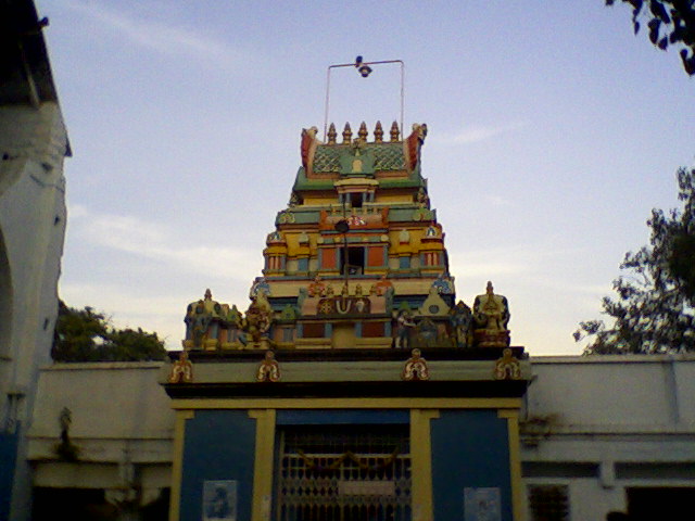   Clockwise from top: Outer Ring Road, Chilkoor Balaji Temple, Rajiv Gandhi International Airport, View of Osman Sagar, Residential buildings at Miyapur | |
| Nickname: RR District | |
 Ranga Reddy district Location in Telangana | |
| Coordinates: 17.3°N 78.1°E | |
| Country | |
| State | |
| Headquarters | Shamshabad |
| Mandals | 27 |
| Founded | 15 August 1978 |
| Founded by | Government of Andhra Pradesh |
| Named for | K. V. Ranga Reddy |
| Government | |
| • Type | District Collectorate |
| • District Collector | Amoy Kumar, IAS |
| Area | |
| • District of Telangana | 7,500 km2 (2,900 sq mi) |
| Population (2020) | |
| • District of Telangana | 3,919,398 |
| • Rank | 2nd |
| • Density | 486/km2 (1,260/sq mi) |
| • Urban | 1,420,152 |
| • Rural | 1,026,113 |
| Languages | |
| • Official | Telugu |
| Time zone | UTC+5:30 (IST) |
| PIN | 500 0XX, 501 5XX, 501 2XX, 501 1XX, 509 3XX |
| Telephone code | 91-, 040, 08413, 08414, 08417 |
| Vehicle registration | TS–07, AP-28(old)[1] |
| Website | rangareddy |
History
The district was formed in 1978 when it was split from Hyderabad district.[5][6] Originally named Hyderabad Rural district, it was renamed after Konda Venkata Ranga Reddy, a freedom fighter who fought for the independence of Telangana from the Nizams and who went on to become the deputy chief minister of Andhra Pradesh.[7] In 2016, it was carved out during the district's reorganisation to create the new Vikarabad district and Medchal–Malkajgiri district.[4]
Geography
Ranga Reddy District occupies an area of approximately 7,500 square kilometres (2,900 sq mi).[8]
A freshwater reservoir, called Osman Sagar, Himayath Sagar, on the river Musi at Gandipet, is the prime drinking water source for the capital city of Hyderabad/Secunderabad.
Demographics
According to the 2011 census, Ranga Reddy District has a population of 2,446,265, of which 1,254,184 were males and 1,192,081 were females.[9] The Sex Ratio (Females per 1000 Males) was 950. The rural population in the district was 1,026,113 (41.95%) while the urban population was 1420152 (58.05%). The literacy rate was calculated to be 71.95%, higher than the state's literacy rate of 66.54%.[10][11]
Economy
- Medium-scale industries and Cement Corporation Of India (CCI)'s cement factories are established at Tandur.
- Another major company is Hyderabad Chemicals and Fertilizers, established at Moula-Ali in 1942.
In 2006 the Indian government named Ranga Reddy one of the country's 250 most backward districts (out of a total of 640).[12] It is one of the 33 districts in Telangana currently receiving funds from the Backward Regions Grant Fund Programme (BRGF).[12]
Administrative divisions
The district will have five revenue divisions: Chevella, Ibrahimpatnam, Rajendranagar, Kandukur and Shadnagar. They are sub-divided into 27 mandals.[3] Amoy Kumar IAS is the present collector of the district.[13][14]
Municipalities/Municipal Corporations
There are 12 Municipalities and 3 municipal corporations in Ranga Reddy district. They are Adibatla, Amangal, Badangpet, Bandlaguda Jagir, Ibrahimpatnam, Jalpally, Manikonda, Meerpet, Narsingi, Pedda Amberpet, Shadnagar, Shamshabad, Shankarpally, Thukkuguda, Thurkayamjal.
Mandals
The table below categorizes mandals into their respective revenue divisions in the district:[3]
| # | Chevella revenue division | Ibrahimpatnam revenue division | Kandukur revenue division | Rajendranagar revenue division | Shadnagar revenue division |
|---|---|---|---|---|---|
| 1 | Chevella | Abdullapuramet | Amangal | Gandipet | Chowderguda |
| 2 | Moinabad | Hayathnagar | Balapur | Rajendranagar | Farooqnagar |
| 3 | Shahbad | Ibrahimpatnam | Kandukur | Serilingampally | Keshampeta |
| 4 | Shankarpalle | Madgul | Kadthal | Shamshabad | Kondurg |
| 5 | Manchal | Maheswaram | Kothur | ||
| 6 | Yacharam | Talakondapalle | Nandigama | ||
| 7 | Saroornagar |
Assembly constituencies
There are 8 assembly constituencies in Ranga Reddy district. They are Chevella, Rajendranagar, L. B. Nagar, Shadnagar, Serlingampally, Ibrahimpatnam and Maheshwaram, Kalwakurthy.
See also
- List of districts in Telangana
References
- "District Codes". Government of Telangana Transport Department. Retrieved 4 September 2014.
- "Collectorate". Ranga Reddy district. Retrieved 19 September 2021.
- "Rangareddy district" (PDF). New Districts Formation Portal. Government of Telangana. Archived from the original (PDF) on 13 October 2016. Retrieved 26 March 2017.
- "Ranga Reddy district set to shrink". The Hindu. 3 October 2016. Retrieved 3 October 2016.
- Law, Gwillim (25 September 2011). "Districts of India". Statoids. Retrieved 11 October 2011.
- "Salient Features of Rangareddy District". Rangareddy District Official Website. Collectorate Rangareddy District. Archived from the original on 21 June 2012. Retrieved 19 December 2012.
- "History | RangaReddy District Government of Telangana | India". Retrieved 10 August 2021.
- Srivastava, Dayawanti; et al., eds. (2010). "States and Union Territories: Andhra Pradesh: Government". India 2010: A Reference Annual (54th ed.). New Delhi, India: Additional Director General, Publications Division, Ministry of Information and Broadcasting (India), Government of India. pp. 1111–1112. ISBN 978-81-230-1617-7.
- ":: RANGAREDDY ::". Archived from the original on 6 March 2015.
- "RANGAREDDY DISTRICT PROFILE | RangaReddy District Government of Telangana | India". Retrieved 10 August 2021.
- "RANGAREDDY DISTRICT PROFILE" (PDF).
- Ministry of Panchayati Raj (8 September 2009). "A Note on the Backward Regions Grant Fund Programme" (PDF). National Institute of Rural Development. Archived from the original (PDF) on 5 April 2012. Retrieved 27 September 2011.
- Mayabrahma, Roja (28 January 2020). "Suryapet collector Amoy Kumar transferred to Rangareddy". The Hans. Retrieved 19 February 2020.
- "Telangana State Portal District Officials".
Capital: Hyderabad | |
| Topics |
|
| Dynasties |
|
| Districts |
|
| Commissionerates |
|
| Major cities | |
| Tourism |
|
| Municipal corporations |
|
| Related lists |
|
Authority control | |
|---|---|
| General |
|
| National libraries | |
На других языках
[de] Rangareddy (Distrikt)
Der Distrikt Rangareddy (Telugu రంగా రెడ్డి జిల్లా, Urdu رنگاریڈی ضلع), auch Rangareddi und Ranga Reddy, ist ein Distrikt des indischen Bundesstaats Telangana. Der Verwaltungssitz liegt in der selbst nicht zum Distrikt gehörenden Stadt Hyderabad.- [en] Ranga Reddy district
[ru] Рангаредди (округ)
Рангаредди (телугу రంగా రెడ్డి జిల్లా; урду رنگاریڈی ضلع; англ. Rangareddy) — округ на западе индийского штата Телангана, до 2014 года входил в состав штата Андхра-Прадеш. Образован 15 августа 1978 года. Административный центр — город Хайдарабад. Площадь округа — 7493 км². По данным всеиндийской переписи 2001 года население округа составляло 3 575 064 человека. Уровень грамотности взрослого населения составлял 66,2 %, что выше среднеиндийского уровня (59,5 %). Доля городского населения составляла 54,2 %.Другой контент может иметь иную лицензию. Перед использованием материалов сайта WikiSort.org внимательно изучите правила лицензирования конкретных элементов наполнения сайта.
WikiSort.org - проект по пересортировке и дополнению контента Википедии