world.wikisort.org - India
Nalgonda district is a district in the Telangana state of India. Nalgonda district has the highest number of mandals in the state with 31 mandals.[2] The district shares boundaries with Suryapet, Rangareddy, Yadadri and Nagarkurnool districts and with the state boundary of Andhra Pradesh.
Nalgonda district | |
|---|---|
District of Telangana | |
 | |
 Nalgonda district Location in Telangana | |
| Country | India |
| State | Telangana |
| Division | Nalgonda, Miryalaguda, Devarakonda |
| Headquarters | Nalgonda |
| Mandalas | 31 |
| Government | |
| • District collector | RAHUL SHARMA .I.A.S. |
| • Parliamentary constituencies | Nalgonda |
| • Assembly constituencies | 6 assembly seats |
| Area | |
| • Total | 7,122 km2 (2,750 sq mi) |
| Population (2011) | |
| • Total | 1,618,416 |
| • Density | 230/km2 (590/sq mi) |
| Demographics | |
| • Literacy | 65.05 |
| Time zone | UTC+05:30 (IST) |
| Vehicle registration | TS – 05[1] |
| Major highways | NH-65, NH-561, SH-2 |
| Average annual precipitation | Normal rainfall 751.0 mm; average rainfall 670.2 mm |
| Website | nalgonda |
Etymology
Nalgonda is derived from two Telugu words Nalla (Black) & Konda (Hills) i.e. Black Hills.[3]
History


Nalgonda was earlier referred to as Neelagiri, the name given by some local rulers and the name was changed to Nallagonda only after its conquest by Allauddin Bahaman Shah, the founder of Bahmani Sultanate .


The district had a major role in the Telangana Rebellion.
Geography
The district is spread over an area of 7,122 square kilometres (2,750 sq mi).[4]
Demographics
As of 2011[update] Census of India, the district has a population of 1,618,416. According to the 2011 census, 81.75% of the population spoke Telugu, 11.91% Lambadi and 5.51% Urdu as their first language.[4]
The Krishna River, Musi River, Aleru, Peddavagu, Dindi River, Halia River and Paleru flow through the Nalgonda district.[5]
Economy

In 2006 the Indian government named Nalgonda one of the country's 250 poorest districts (out of a total of 640).[6] It is one of the thirty-three districts in Telangana currently receiving funds from the Backward Regions Grant Fund Programme (BRGF).[6]
Agriculture
Nalgonda district is an agrarian district with water resources from the rivers, lakes, canals and ponds. The wells and borewells also support farming in the district. The farmers mainly grow crops such as paddy, and cotton. The climate of the district supports the production of paddy and groundnut seeds.[7][8]
Geography
Cities
Towns
Villages
Power Projects
Telangana State Power Generation Corporation Limited (TSGENCO) is building Yadadri Thermal Power Plant in Nalgonda District.[9] The 4000 megawatt thermal project is coming up in a phased manner at Veerlapalem in the district. Bharat Heavy Electricals Limited (BHEL) is appointed as the engineering, procurement, and construction (EPC) contractor for the project.[10]
Notable places in District
- Kurmagiri Narasimha Swamy Temple, Palem ( 16 Miles) from Nalgonda
- Latif Saheb Hill in Nalgonda
- Sri Chaya Someshwara Temple - 5 km (3.1 mi) from Nalgonda
- Udaya Samudram -6 km (3.7 mi) from Nalgonda
- Cheruvugattu Shivalayam - 14 km (8.6 mi) from Nalgonda[11]
- Devarkonda Fort - 60 km (37 mi) from Nalgonda
- Nagarjuna sagar Dam - 64 km (40 mi) from Nalgonda
Administrative divisions
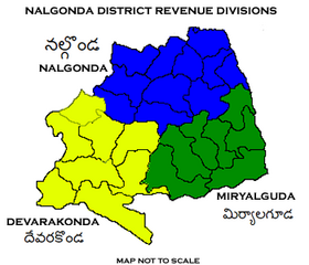
The district is divided into three revenue divisions: Nalgonda, Miryalaguda, and Devarakonda. These are sub-divided into 31 mandals and has 565 villages.[4] Prashanth Jeevan Patil is the present collector of the district.[12]
Mandals
The below table categorizes the mandals into their respective revenue divisions in the district:
| Sr No. | Nalgonda Division | Miryalaguda Division | Devarakonda Division |
|---|---|---|---|
| 1 | Chandur | Dameracherla | Chandampet |
| 2 | Chityal | Miryalaguda | Chintapally |
| 3 | Kanagal | Vemulapally | Devarakonda |
| 4 | Kattangur | Anumula (Halia) | Gundlapally |
| 5 | Gurrampode | Nidamanur | |
| 6 | Munugode | Peddavoora | Kondamallepally |
| 7 | Nakrekal | Tripuraram | Nampally |
| 8 | Nalgonda | Madugulapally | Marriguda |
| 9 | Narayanapur | Thirumalagiri Sagar | Pedda Adiserla Pally |
| 10 | Narketpally | Adavi Devulapally | Neredugommu |
| 11 | Shaligowraram | ||
| 12 | Thipparthy | ||
| 13 | Ghattuppal | ||

See also
- Chinna Kaparthy
- Dandampally
- List of districts in Telangana
References
- "Vehicle Registration Codes for New Districts in Telangana".
- "Census GIS India". Censusindiamaps.net. Archived from the original on 3 July 2007. Retrieved 13 June 2012.
- "Nalgonda travel guide". World66.com. Retrieved 13 June 2012.
- "New districts". Andhra Jyothy.com. 8 October 2016. Retrieved 8 October 2016.
- "IRRIGATION PROFILE OF NALGONDA DISTRICT". irrigation.telangana.gov.in. Retrieved 18 February 2022.
- Ministry of Panchayati Raj (8 September 2009). "A Note on the Backward Regions Grant Fund Programme" (PDF). National Institute of Rural Development. Archived from the original (PDF) on 5 April 2012. Retrieved 27 September 2011.
- "Agriculture | Nalgonda,Government Of Telangana | India". Retrieved 18 February 2022.
- "Telangana | DISTRICTS OF INDIA". districts.nic.in. Retrieved 25 February 2022.
- Yadadri Thermal Power Plant Project, Telengana, India (nsenergybusiness.com)
- "BHEL's largest Order: Super Critical 20,400 Cr Yadadri TPP – CableCommunity.com". Retrieved 27 February 2022.
- "Cheruvugattu , తెలుగు". wikiedit.org. Retrieved 18 February 2022.
- "Who's who". 26 February 2020. Retrieved 26 February 2020.
External links
Places adjacent to Nalgonda district | ||||||||||||||||
|---|---|---|---|---|---|---|---|---|---|---|---|---|---|---|---|---|
| ||||||||||||||||
Capital: Hyderabad | |
| Topics |
|
| Dynasties |
|
| Districts |
|
| Commissionerates |
|
| Major cities | |
| Tourism |
|
| Municipal corporations |
|
| Related lists |
|
Authority control | |
|---|---|
| General |
|
| National libraries | |
На других языках
[de] Nalgonda (Distrikt)
Der Distrikt Nalgonda (Telugu నల్గొండ జిల్లా, Urdu نلگنڈہ ضلع), auch Nallagonda, ist ein Distrikt des indischen Bundesstaats Telangana. Verwaltungssitz ist die Stadt Nalgonda.- [en] Nalgonda district
[ru] Налгонда (округ)
Налгонда (телугу నల్లగొండ; англ. Nalgonda) — округ в центральной части индийского штата Телангана, до 2014 года входил в состав штата Андхра-Прадеш. Административный центр — город Налгонда. Площадь округа — 14 240 км². По данным всеиндийской переписи 2001 года население округа составляло 3 247 982 человека. Уровень грамотности взрослого населения составлял 57,2 %, что немного ниже среднеиндийского уровня (59,5 %). Доля городского населения составляла 13,3 %.Другой контент может иметь иную лицензию. Перед использованием материалов сайта WikiSort.org внимательно изучите правила лицензирования конкретных элементов наполнения сайта.
WikiSort.org - проект по пересортировке и дополнению контента Википедии