world.wikisort.org - India
Krishna district is district in the coastal Andhra Region in Indian state of Andhra Pradesh, with Machilipatnam as its administrative headquarters. It is the coastal district of Andhra Pradesh. Machilipatnam is the most populated city in the district. It is surrounded on the east by Bay of Bengal, west by Guntur and north by Eluru and NTR districts and south again by Bay of Bengal.[3][4] In 2022 Krishna district was divided into Krishna and NTR districts.[5]
This article needs additional citations for verification. (July 2014) |
Krishna district | |
|---|---|
District of Andhra Pradesh | |
  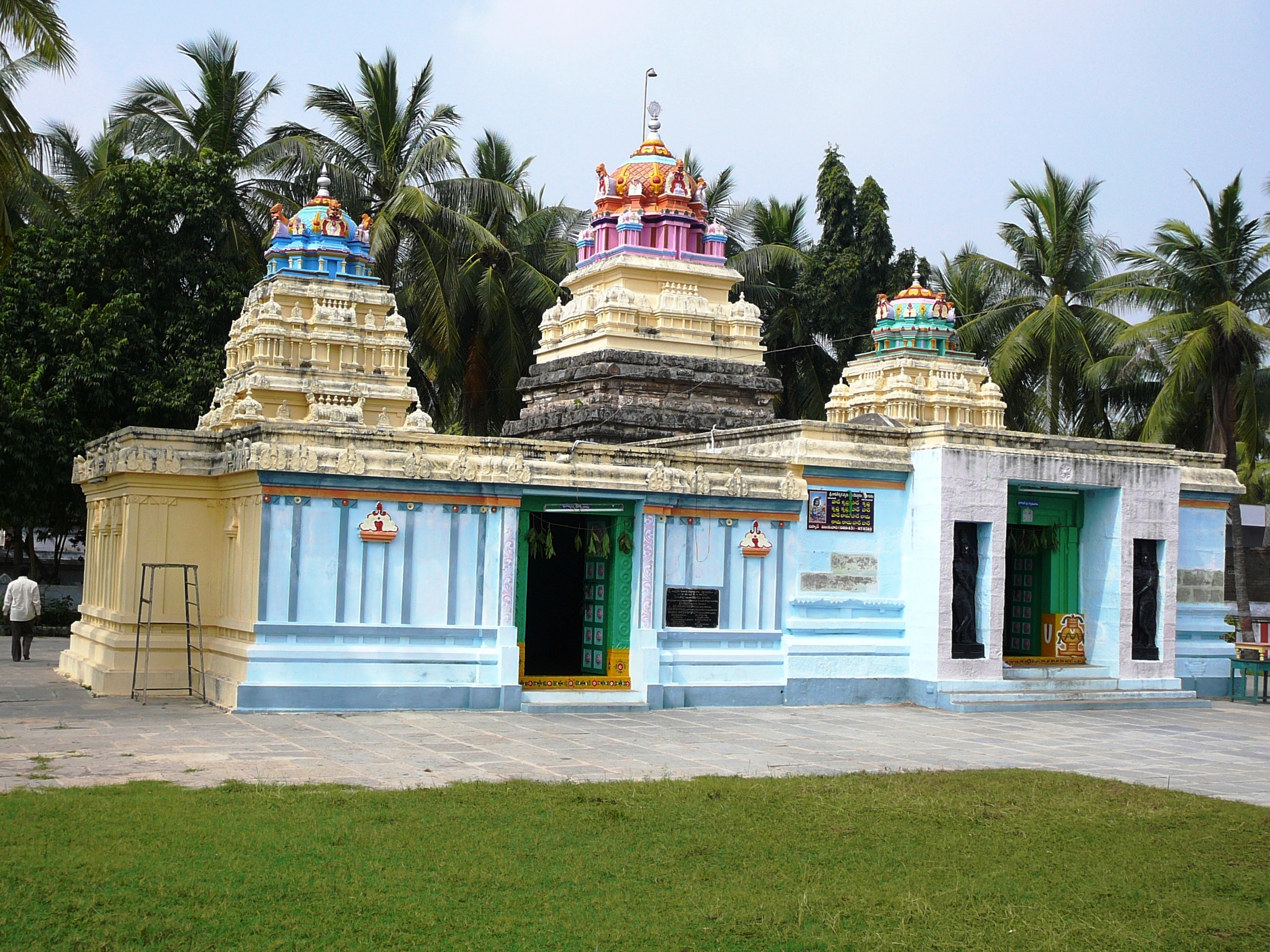   Clockwise from top-left: Machillipatnam beach , Challapalli Kota, Srikakulam Temple , River Krishna meets bay of Bengal at Hamdaladeevi,
Vijayawada Airport | |
 Location of Krishna district in Andhra Pradesh | |
| Coordinates (Machilipatnam): 16°17′N 81°13′E | |
| Country | |
| State | |
| Region | Coastal Andhra |
| Headquarters | Machilipatnam |
| Mandals | 25 |
| Government | |
| • District collector and magistrate | P Ranjit Basha, IAS |
| • Superintendent of Police | P Joshua, IPS |
| • Lok Sabha constituencies | Machilipatnam |
| • Member of Parliament | Vallabhaneni Balasouri |
| • Assembly constituencies | 07 |
| Area | |
| • Total | 3,773 km2 (1,457 sq mi) |
| Population (2011)[1] | |
| • Total | 1,735,079 |
| • Density | 460/km2 (1,200/sq mi) |
| Demographics | |
| • Literacy | 73.74% |
| • Sex ratio | 996 |
| Vehicle registration | AP-16 (former) AP–39 (from 30 January 2019)[2] |
| Major highways | AH-45, NH-65, NH-221, NH-216 |
| Website | krishna |

Etymology
Krishna district, with its district headquarters at Machilipatnam was formerly called Machilipatnam district. Later it was renamed as Krishna district, by adding certain Taluks of the abolished Guntur District in 1859 with Machilipatnam with its head. It was named after the Krishna River, the third longest river in India. The river flows through the state of Andhra Pradesh before it empties itself into Bay of Bengal, near Hamsaladevi village of Krishna district.[3][non-primary source needed]
History

This history of this region dates back to the 2nd century BCE. The area was ruled by the Satavahanas (230 BC – AD 227); Pallavas (AD 340 – AD 500), Chalukyas (AD 615 – 1070 AD) and later by Cholas, Kakatiyas, Musunuri Nayaks, Reddy dynasty and Gajapati kings of Odisha.[6]

Satavahana period (230 BC – AD 227): The Satavahanas ruled this region with headquarters at Srikakulam. Prominent rulers during this period were Srimukha (founder), Gotamiputra Satakarni and Yajnasri Satakarni (last Satavahana king). The Satavahanas imparted more stability and security to the life of the people of the region for more than four centuries. Pallava Kingdom (AD 340 – AD 500), spread over from Krishna river to Tungabhadra, including Amaravati in the East, Bellary in the West and Kancheepuram in the South with capital cities at venginagar near Eluru and Pithapuram, both in Vengidesa. Bruhitpalayanas, the contemporaries of Pallavas who ruled the district with Koduru as their capital. Vishnukundinas (AD 5th century), are rulers who excavated cave temples at Mogalrajapuram (now in Vijayawada) and Undavalli, etc.
Eastern chalukyas (AD 615 – AD 1070), the entire Andhra country was under the control of a single ruler under their reign. The Eastern Chalukyas were credited with the excavations of the cave temple at Undavalli and rock cut shrines and Shiva temples.[6]
Cholas ruled this region with capital at Rajamahendri . It was during Rajarajanaredra's reign that Nannayya Bhattu translated the Mahabharata into Telugu. Kakatiyas, ruled this region up to the early 14th century with Orugallu as their capital and followed by Musunuri Nayaks who rebelled against Delhi sultanate and won. Musunuri Nayaks constructed various forts in South India including Hampi and ruled many states of India independently. Reddy dynasty, on the downfall of Pratapa Rudra of Kakatiya, the eldest son of Prolaya Vema reddi, a subordinate of Musunuri Kapaya Naidu found himself independent and established himself in the hill fort of Kondavedu. The Kondavidu Reddi's were great patrons of Telugu literature. The poet Srinadha and his brother-in –law Bammera Pothana flourished at his court. The ruins of fortresses at Kondavidu can be seen[6]
Gajapathis of Odisha: Kapileswara Gajapathi is preserved by the village Kapileswarapuram now in Pamidimukkala mandal. He was succeeded by Vidyadhara Gajapathi who built Vidyadharapuram (now in Vijayawada) and constructed a reservoir at Kondapalli. Krishnadevaraya of Vijayanagara empire conquered this region in the early 16th century. Qutb Shahis, in 1512, the Kingdom of Golconda was founded by one Sultan Quli Qutub Shah. The Kingdom of Golconda included this district within its limits. Abu-l-Hussain Shah was the last of Qutab Shahi dynasty known as Tanisha. He had two ministers, both Brahmins, named Madanna and Akkanna. Popular tradition attributed this preference of Vijayawada to the devotion of the two ministers to the goddess Kanaka Durga.[6]
Medieval period
The Emperor Aurangazeb included this district in the province of Golconda, which remained under Asaf jah who was appointed as Subedar or Viceroy of the Deccan in AD 1713 with the title of Nizam-ul-Mulk. The province of Golconda comprised five Nawabs’ charges viz. Arcot, Cuddapah, Kurnool, Rajahmundry and Chicacole (Srikakulam). The Nawab of Rajahmundry ruled the country induced in the Krishna district.[6]
The British: In the year 1611 the English founded their settlement at Masulipatnam which was their headquarters until they finally moved to Madras in 1641. The Dutch and French also had settlements at Masulipatnam. Upon the death of the old Nizam-ul-Mulk in June 1748 his heirs strove for the succession with the support of the English and the French. When Nizam Ali Khan was proclaimed ruler of Golconda in 1761 the British secured at first the divisions of Masulipatnam, Nizampatnam and part of Kondaveedu and later the entire Circars. At first the district was administered by a chief and council at Masulipatnam but in 1794 Collectors, directly responsible to the Board of Revenue, were appointed at Masulipatnam.[6]
The Krishna District was formed from the District of Rajahmundry in 1859, when it also included the present day Guntur and West Godavari districts. Guntur was separated from Krishna in 1904, and West Godavari in 1925, giving rise to the present day Krishna district.[7][8][needs update]
Demographics
As of 2011[update] census of India, the district had a population of 4,517,398 with a density of 518 persons per km2. The total population constitute, 2,267,375 males and 2,250,023 females –a ratio of 992 females per 1000 males. The total urban population is 1,843,660 (40.81%).[8]: 20 There are 3,009,718 literates with a literacy rate of 73.74%.[8]: 21
After reorganization the district had a population of 17,35,079. Scheduled Castes and Scheduled Tribes make up 346,989 (20.00%) and 37,716 (2.17%) of the population respectively.[1]: 79–83
| Year | Pop. | ±% p.a. |
|---|---|---|
| 1901 | 861,068 | — |
| 1911 | 993,086 | +1.44% |
| 1921 | 1,059,731 | +0.65% |
| 1931 | 1,229,176 | +1.49% |
| 1941 | 1,413,516 | +1.41% |
| 1951 | 1,736,429 | +2.08% |
| 1961 | 2,076,956 | +1.81% |
| 1971 | 2,493,574 | +1.84% |
| 1981 | 3,048,463 | +2.03% |
| 1991 | 3,698,833 | +1.95% |
| 2001 | 4,187,841 | +1.25% |
| 2011 | 4,517,398 | +0.76% |
| source:[9] | ||
According to the 2011 census, 93.30% of the population spoke Telugu and 5.97% Urdu as their first language.[11]
Geography

Krishna district is surrounded on the east by Bay of Bengal, west by Guntur and Bapatla districts and north by Eluru and NTR districts and south by Bay of Bengal. The Krishna district occupies an area of 3,775 square kilometres (1,458 sq mi),[12] It has a total coastline of 88 km (55 mi).[13]
Topography

The main hill range of the district known as Kondapalli runs between Nandigama and Vijayawada with a length of about 24 km. The other smaller hill ranges are Jammalavoidurgam, Mogalrajapuram and Indrakiladri hills. Kolleru, is the large freshwater lake in India. It spans into two districts – Krishna and West Godavari.
Flora and fauna
The forest occupies only 9 percent of the total district area. However, it contains Reserved Forest areas in Nandigama, Vijayawada, Tiruvuru, Nuzvid, Gannavaram, Machilipatnam and Divi Seema Talukas. A type of light wood known as ‘Ponuku’ (Gyrocapus Jacquini) is found in the Kondapalli hills. The wood is used for the manufacture of the well known Kondpalli toys. The most noticeable trees are pterocarpus, Terminalia, Anogeissus and Logustroeinai and Casuarina.[14]
Panthers, hyenas, jungle cats, foxes, bears and other carnivorous mammalian fauna are found here. Deer, spotted deer sambar, blackbuck and other herbivorous animals are found in the inland forests. The district has a large number of Murrah buffaloes and cows.[14]
Climate
The climatic conditions of the district consist of extremely hot summers and moderately hot winters and may be classified as tropical. The period starting from April to June is the hottest. The annual rainfall in the region is about 1028 mm and is contributed to by the Southwest monsoon. Three types of soils viz., Black Cotton (57.6 percent), Sand clay loams (22.3 percent) and Red loams (19.4 percent).
| Climate data for Vijayawada (1951–1980) | |||||||||||||
|---|---|---|---|---|---|---|---|---|---|---|---|---|---|
| Month | Jan | Feb | Mar | Apr | May | Jun | Jul | Aug | Sep | Oct | Nov | Dec | Year |
| Average high °C (°F) | 30.0 (86.0) |
32.7 (90.9) |
35.4 (95.7) |
37.4 (99.3) |
39.8 (103.6) |
37.2 (99.0) |
33.2 (91.8) |
32.4 (90.3) |
32.6 (90.7) |
31.8 (89.2) |
30.7 (87.3) |
29.6 (85.3) |
33.6 (92.5) |
| Average low °C (°F) | 18.7 (65.7) |
20.1 (68.2) |
22.4 (72.3) |
25.5 (77.9) |
27.5 (81.5) |
27.0 (80.6) |
25.4 (77.7) |
25.1 (77.2) |
25.1 (77.2) |
24.0 (75.2) |
21.3 (70.3) |
19.1 (66.4) |
23.4 (74.1) |
| Average precipitation mm (inches) | 0.9 (0.04) |
5.3 (0.21) |
9.6 (0.38) |
14.3 (0.56) |
51.3 (2.02) |
131.9 (5.19) |
218.4 (8.60) |
185.6 (7.31) |
163.5 (6.44) |
142 (5.6) |
51.3 (2.02) |
6.7 (0.26) |
998.2 (39.30) |
| Average precipitation days | 0.1 | 0.4 | 0.5 | 1.0 | 3.1 | 7.6 | 12.6 | 11.5 | 8.8 | 7.1 | 2.8 | 0.6 | 56.1 |
| Source: India Meteorological Department. | |||||||||||||
Economy
The Gross District Domestic Product (GDDP) of the district is ₹62,726 crore (US$7.9 billion) and it contributes 12% to the Gross State Domestic Product (GSDP). For the FY 2013–14, the per capita income at current prices was ₹104,897 (US$1,300). The primary, secondary and tertiary sectors of the district contribute ₹17,780 crore (US$2.2 billion), ₹8,967 crore (US$1.1 billion) and ₹35,979 crore (US$4.5 billion) respectively.[13]
The major products contributing to the GVA of the district from agriculture and allied services are, paddy, sugarcane, mango, tomato, milk, meat and fisheries. The GVA to the industrial and service sector is contributed from construction, electricity, manufacturing, transport and software services.[13]
Administrative divisions
The district has three revenue divisions, namely Machilipatnam, Gudivada and Vuyyuru, each headed by a sub collector. These revenue divisions are divided into 25 mandals in the district. These 25 mandals consist of unknown number of mandal parishads, unknown number of panchayats, unknown number of villages and 3 municipalities.[15] There are unknown number of towns (or urban settlements) in the district, including 1 municipal corporation, 3 municipalities, unknown number of nagar panchayat and unknown number of census towns. Machilipatnam is the only municipal corporation and the 3 municipalities in the district are Gudivada, Pedana and Vuyyuru. The unknown number of census towns are TBA.
Mandals
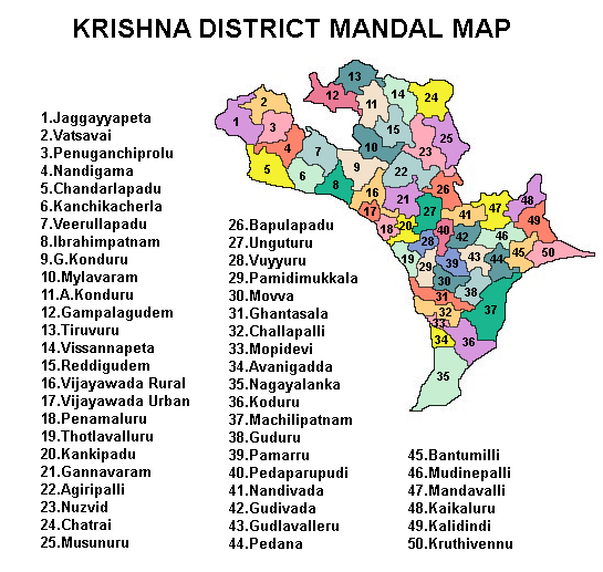
The list of 25 mandals in Krishna district[16] under 3 revenue divisions are listed in the following table:
Politics
The Parliamentary constituency is Machilipatnam Lok Sabha constituency
The Assembly segment comprises the following Legislative Assembly segments:[17]
| Constituency number | Name | Reserved for (SC/ST/None) |
Parliament |
|---|---|---|---|
| 71 | Gannavaram | None | Machilipatnam Lok Sabha constituency |
| 72 | Gudivada | None | Machilipatnam Lok Sabha constituency |
| 74 | Pedana | None | Machilipatnam Lok Sabha constituency |
| 75 | Machilipatnam | None | Machilipatnam Lok Sabha constituency |
| 76 | Avanigadda | None | Machilipatnam Lok Sabha constituency |
| 77 | Pamarru | SC | Machilipatnam Lok Sabha constituency |
| 78 | Penamaluru | None | Machilipatnam Lok Sabha constituency |
Source: Assembly segments of Parliamentary constituencies[17]
Erstwhile Talukas
- Before Formation of mandals, Administration was done through Taluka system
- Krishna District had 10 Talukas in 1971, later in 1978 they were increased to 21 Talukas
- In 1985, Mandal system was created and 50 mandals were formed in the district
- In 2022, Krishna district was divided into two districts forming NTR district which left Krishna district with 25 mandals
| S.No. | Erstwhile Talukas
in 1971 |
Newly Formed Talukas
in 1978 |
Newly Formed Mandals
in 1985 |
|---|---|---|---|
| 1 | Bandar | Bandar | Machilipatnam, Gudur, Pedana [part], Gudlavalleru [part] |
| Bantumilli [11] | Bantumilli, Kruthivennu, Pedana [part] | ||
| 2 | Divi [Avanigadda] | Divi | Avanigadda, Nagayalanka, Koduru, |
| Movva [12] | Movva, Ghantasala, Challapalle, | ||
| 3 | Gannavaram | Gannavaram | Gannavaram, Ungutur, Bapulapadu [part] |
| Vuyyur [13] | Vuyyur, Pamidimukkala, Thotlavalluru [part] | ||
| 4 | Vijayawada | Vijayawada | Vijayawada Urban, Vijayawada Rural, Penamaluru, Kankipadu, Thotlavalluru [part], |
| Mylavaram [14] | Mylavaram, Ibrahimpatnam, G.Konduru, | ||
| 5 | Nandigama | Nandigama | Nandigama, Penuganchiprolu, Chandralapadu, |
| Kanchikacherla [15] | Kanchikacherla, Veerullapadu | ||
| 6 | Jaggaayyapet | Jaggayyapet | Jaggayyapet, Vatsavai |
| 7 | Tiruvur | Tiruvur | Tiruvuru, Gampalagudem, A.Konduru [part] |
| Vissannapeta [16] | Vissannapeta, Reddigudem, Chatrai, A.Konduru [part] | ||
| 8 | Nuzvid | Nuzvid | Nuzvid, Agiripalle, Musunuru, Bapulapadu [part], |
| 9 | Gudivada | Gudivada | Gudivada, Nandivada, Gudlavalleru [part], Mudinepalle [part], |
| Pamarru [17] | Pamarru, Pedaparupudi, Gudlavalleru [part] | ||
| 10 | Kaikalur | Kaikalur | Kaikalur, Kalidindi, Mudinepalle [part], |
| Mandavalli [18] | Mandavalli, Mudinepalle [part] |
Towns in district
Largest cities or towns in Krishna District As per the 2011 Census | |||||||||
|---|---|---|---|---|---|---|---|---|---|
| Rank | Division | Pop. | |||||||
 Vijayawada  Machilipatnam |
1 | Vijayawada | Vijayawada Division | 1,179,395 |  Gudivada  Nuzvid | ||||
| 2 | Machilipatnam | Machilipatnam Division | 169,892 | ||||||
| 3 | Gudivada | Gudivada Division | 118,167 | ||||||
| 4 | Nuzvid | Nuzvid Division | 58,590 | ||||||
| 5 | Jaggayyapeta | Vijayawada Division | 53,530 | ||||||
| 6 | Nandigama | Vijayawada Division | 44,395 | ||||||
| 7 | Vuyyuru | Nuzvid Division | 38,021 | ||||||
| 8 | Tiruvuru | Nuzvid Division | 34,173 | ||||||
| 9 | Kondapalli | Vijayawada Division | 33,373 | ||||||
| 10 | Pedana | Machilipatnam Division | 30,721 | ||||||
| Municipal body | Civic status | Formation year | No. of
wards |
2011 Census
population |
2001 Census
population |
1991 Census
population |
1981 Census
population |
1971 Census
population |
1961 Census
population |
1951 Census
population |
|---|---|---|---|---|---|---|---|---|---|---|
| Machilipatnam | Municipal Corporation | 1866 | 50 | 1,69,892 | 1,79,353 | 1,59,110 | 1,38,530 | 1,12,612 | 1,01,417 | 77,953 |
| Gudivada | Municipality Grade - Special | 1937 | 36 | 118,167 | 113,054 | 101,656 | 80,198 | 61,068 | 44,801 | 31,942 |
| Vuyyuru | Nagar Panchayat | 2011 | 20 | 38,021 | 36,423 | 30,962 | 23,369 | 17,455 | 14,489 | 14,427 |
| Pedana | Municipality Grade - 3 | 1985 | 23 | 30,721 | 29,613 | 27,497 | 25,200 | 20,970 | 15,033 | 11,636 |
Note -
** Vijayawada Population shown here is only, Municipal Corporation Population.
** Vijayawada Urban Agglomeration Population is 14,76,931
| Town | Mandal HQ | Civic status | 2011 Census
population |
2001 Census
population |
1991 Census
population |
1981 Census
population |
|---|---|---|---|---|---|---|
| Kanuru | Penamaluru | Census Town | 49,006 | 30,369 | 23,597 | -- |
| Yenamalakuduru | Penamaluru | Census Town | 34,177 | -- | -- | -- |
| Ibrahimpatnam | Ibrahimpatnam | Census Town | 29,432 | 22,020 | -- | -- |
| Poranki | Penamaluru | Census Town | 25,545 | 20,155 | -- | -- |
| Ramavarappadu | Vijayawada Rural | Census Town | 22,222 | -- | -- | -- |
| Nadim Tiruvuru | Tiruvuru | Census Town | 18,567 | -- | -- | -- |
| Tadigadapa | Penamaluru | Census Town | 17,462 | 12,947 | -- | -- |
| Kankipadu | Kankipadu | Census Town | 14,616 | 13,026 | -- | -- |
| Prasadampadu | Vijayawada Rural | Census Town | 13,941 | -- | -- | -- |
| Guntupalli | Ibrahimpatnam | Census Town | 11,187 | 12,011 | -- | -- |
| Town | Civic Status | 2011 Census
population |
2001 Census
population |
1991 Census
population |
1981 Census
population |
1971 Census
population |
1961 Census
population |
|---|---|---|---|---|---|---|---|
| Avanigadda | Grama Panchayat | 23,737 | 23,791 | 21,701 | 19,375 | 15,349 | 11,949 |
| Kanchikacherla | Grama Panchayat | 22,756 | 20,112 | -- | -- | -- | -- |
| Mylavaram | Grama Panchayat | 21,763 | 18,882 | -- | -- | -- | -- |
| Pamarru | Grama Panchayat | 21,395 | 22,368 | -- | -- | -- | -- |
| Kaikalur | Grama Panchayat | 21,292 | 20,753 | 17,491 | 13,223 | 9,626 | 7,051 |
| Gannavaram | Grama Panchayat | 20,728 | 20,442 | 16,351 | 12,478 | 9,021 | 6,702 |
| Bantumilli | Grama Panchayat | 6,867 | 8,028 | -- | -- | -- | -- |
| Movva | Grama Panchayat | 5,653 | 6,277 | -- | -- | -- | -- |
| Mandavalli | Grama Panchayat | 4,996 | 5,076 | -- | -- | -- | -- |
Politics
Krishna district has one parliamentary constituency namely Machilipatnam. There are seven assembly constituencies namely, Gannavaram, Gudivada, Pedana, Machilipatnam, Avanigadda, Pamarru (SC), Penamaluru.[18] Telugu Desam Party, Jana Sena party, YSR Congress, Bharatiya Janata Party, Lok Satta, CPI and CPM are the main political parties in the district.
Culture

The culture of Krishna district is mostly traditional in rural places and moderately modern in Gudivada and Machilipatnam. It is also famous as the birthplace for Indian classical dance named Kuchipudi and the culture with the dialect of Telugu spoken in Krishna is widely considered to be the standard form of Telugu.[19]
Transport
Road
The District is well served by Roads and Railways. 502 villages (including some of the major hamlets) have been connected with transport facilities.[20] The total road length of state highways in the district is 1,188 km (738 mi).[21][13] Four national highways pass through the district namely NH16 from Chennai to Kolkata, NH 65 from Pune to Machilipatnam, NH165 from Pamarru to Palakollu, NH216 from Ongole to Kathipudi.
APSRTC is the major road transport corporation, operates Bus services from District headquarters Machilipatnam to Vijayawada, Eluru, Hanuman Junction, Gudivada, Avanigadda, Repalle, Kakinada, Narsapuram, Bhimavaram, Visakhapatnam, Srikakulam, Palasa, Palakonda, Parvathipuram, Rajahmundry.
Rail
There exists 97 km (60 mi) of rail network in the district. Gudivada Junction railway station is the major railway junction in the district and Machilipatnam railway station is the major railway station in the district.[20]
Water
A minor sea port is at Machilipatnam.[22]
Air
Krishna district is served by NTR Amaravati International airport located in Gannavaram.[23]
Education
The primary and secondary school education is imparted by government, aided and private schools, under the School Education Department of the state.[24][25] As per the school information report for the academic year 2015–16, there are a total of 4,449 schools. They include, 15 government, 2,432 mandal and zilla parishads, 3 residential, 1748 private, 2 model, 3 Kasturba Gandhi Balika Vidyalaya (KGBV), 180 municipal and 66 other types of schools.[26] The total number of students enrolled in primary, upper primary and high schools of the district are 562,510.[27]
Dr.Gururaju Government Homoeo Medical college and Regional Research Institute for Homoeopathy are located in Gudivada. Krishna University is located in Machilipatnam. Rajiv Gandhi University of Knowledge Technologies, Nuzvid is situated in Nuzvid. School of Planning and Architecture is present in Gudavalli.
District has numerous engineering colleges including Prasad V. Potluri Siddhartha Institute of Technology, Velagapudi Ramakrishna Siddhartha Engineering College, Lakireddy Bali Reddy Engineering College, Gudlavalleru Engineering College, DMS SVH College of Engineering, SRR & CVR Govt. Degree College is one of the oldest colleges. It was established in 1937. Govt Polytechnic Vijayawada (one of the oldest Polytechnic colleges in India), Andhra Loyola College, AANM & VVRSR (Gudlavalleru) Polytechnic College, Mary Stella college, Sidhartha Degree College are a few of the many famous arts and science colleges in the district.
Sports
Kabbadi is the most popular sport, followed by cricket, volleyball, badminton, basketball and tennis.
Indira Gandhi Municipal Stadium in Vijayawada hosts One Day Internationals Cricket matches of India. Only one international cricket match was played between India and West Indies on 24 November 2002 at Indira Gandhi stadium. It was won by West Indies. On 12 December 1997 Women's Cricket Worldcup only a group match was played between England Women's Cricket Team and Pakistan women's cricket team, and it was won by England. Dandamudi Rajagopal Indoor Stadium in Vijayawada .
NTR Stadium is the main sports venue in Gudivada. It is used for several sports, like athletics, volleyball, cricket practice, kho kho, kabaddi, badminton, tennis and basketball.[28] Famous Hockey player Balram belongs to this District.
It is also the stadium for Krishna District Cricket Association. Mangalagiri International Cricket Stadium is being built in a 20-acre (8.1 ha) site in Navuluru, village of Mangalagiri town, Guntur district, about 15 km from the city of Vijayawada. The exclusive stadium of the Andhra Cricket Association will be the venue for international and Ranji matches.[29]
Notable people
Many notable people are associated with this district, including:
Science and technology
- Kakarla Subba Rao
- Prof. Kanuri Lakshmana Rao, engineer
- Veluri Venkata Krishna Sastry, archaeologist and historian
Fine arts and literature
- Tripuraneni Ramaswamy (Lawyer, playwright, poet, Avadhanam)
- Dr. Mangalampalli Balamuralikrishna
- Gudipati Venkatachalam
- Jaladi Raja Rao (lyricist)
- Mahakavi Kshetrayya
- Nanduri Venkata Subba Rao (poet)
- Satyam Sankaramanchi (Amaravati Kathalu)
- Siddhendra Yogi (architect)
- Vempati Chinna Satyam (promoter of Kuchipudi dance)
- Veturi
- Yaddanapudi Sulochana Rani
- Viswanatha Satyanarayana
Social reformers
- Dr. Jayaprakash Narayan (president of Loksatta Party)
- Duggirala Gopalakrishnayya Andhra Ratna
- Kasinadhuni Nageswara Rao (Andhra Patrika)
- Pingali Venkayya (designer of Indian National Flag)
Sports
- C.K Nayudu (cricket)
- Chetan Anand (badminton)
- Dandamudi Rajagopal (weightlifting)
- Jyothi Surekha Vennam(archery)
- Koneru Humpy (chess)
Cinema
- Nandamuri Taraka Rama Rao
- Akkineni Nageswara Rao
- Ajay
- Dandamudi Rajagopal
- Chandra Mohan
- Gadde Rajendra Prasad
- Ghantasala
- Jagapathi Babu
- Jandhyala
- Kaikala Satyanarayana
- Kota Srinivasa Rao
- Laya
- Mani Sharma
- Meghna Naidu
- Nadeem Baig
- Nirmalamma
- Nutan Prasad
- Raghupathi Venkaiah Naidu
- Rambha
- Ramoji Rao Cherukuri
- Rajasulochana
- S. V. Ranga Rao
- Sobhan Babu
- Subbaraya Sharma
- Sudheer Babu
- Suthi Veerabhadra Rao
- Suthivelu
- Veturi
See also
- Coastal Andhra
- List of villages in Krishna district
References
- "District Census Hand Book – Krishna" (PDF). Census of India. Registrar General and Census Commissioner of India.
- "New 'AP 39' code to register vehicles in Andhra Pradesh launched". The New Indian Express. Vijayawada. 31 January 2019. Archived from the original on 21 November 2020. Retrieved 9 June 2019.
- "Krishna district". AP state portal. Archived from the original on 6 February 2016. Retrieved 18 January 2016.
- "NEW_District Profile | Krishna District, Government of Andhra Pradesh | India". Retrieved 3 April 2022.
- "Andhra Pradesh's 13 New Districts: Here's All About Them – From Planning to Formation | Explained". News18. 5 April 2022. Retrieved 9 April 2022.
- "History". Krishna district website. Archived from the original on 29 February 2016. Retrieved 23 September 2015.
- "Archived copy" (PDF). Archived from the original (PDF) on 24 July 2015. Retrieved 20 June 2015.
{{cite web}}: CS1 maint: archived copy as title (link) - "District Census Handbook – Guntur" (PDF). Census of India. The Registrar General & Census Commissioner. Retrieved 13 May 2016.
- Decadal Variation In Population Since 1901
- "Population by Religion - Andhra Pradesh". censusindia.gov.in. Office of the Registrar General & Census Commissioner, India. 2011.
- "Table C-16 Population by Mother Tongue: Andhra Pradesh". Census of India. Registrar General and Census Commissioner of India.
- Srivastava, Dayawanti (2010). "States and Union Territories: Andhra Pradesh: Government". India 2010: A Reference Annual (54th ed.). New Delhi, India: Additional Director General, Publications Division, Ministry of Information and Broadcasting (India), Government of India. pp. 1111–1112. ISBN 978-81-230-1617-7.
- "Economy of Krishna District". Andhra Pradesh Economic Development Board. Retrieved 25 April 2017.
- "Flora and Fauna of Krishna district". AP forest department. Archived from the original on 25 January 2014. Retrieved 14 July 2014.
- "Administrative Setup". Krishna District Official Website. Archived from the original on 20 October 2014. Retrieved 20 November 2014.
- "Krishna district profile - AP Government - 4 April 2022" (PDF).
- "Delimitation of Parliamentary and Assembly Constituencies Order, 2008" (PDF). The Election Commission of India. p. 31.
- "Assembly Constituencies – Krishna district" (PDF). Geographic Information Systems. Archived from the original (PDF) on 17 April 2012. Retrieved 15 July 2014.
- "District profile". Krishna District. National Informatics Centre. Archived from the original on 12 June 2014. Retrieved 16 June 2014.
- "Krishna District, Government of Andhra Pradesh | India". Retrieved 26 June 2022.
- "Existing State Highways" (PDF). Andhra Pradesh Road Development Corporation. Government of Andhra Pradesh. p. 1. Archived from the original (PDF) on 20 September 2018. Retrieved 11 May 2019.
- "About District | Krishna District, Government of Andhra Pradesh | India". Retrieved 26 June 2022.
- "NTR Amaravati International Airport | Airports Authority of India".
- "School Education Department" (PDF). School Education Department, Government of Andhra Pradesh. Archived from the original (PDF) on 21 October 2016. Retrieved 7 November 2016.
- "The Department of School Education – Official AP State Government Portal". ap.gov.in. Archived from the original on 7 November 2016. Retrieved 7 November 2016.
- "School Information Report". Commissionerate of School Education. Government of Andhra Pradesh. Archived from the original on 8 November 2016. Retrieved 8 November 2016.
- "Student Information Report". Commissionerate of School Education. Child info 2015–16, District School Education – Andhra Pradesh. Archived from the original on 22 May 2015. Retrieved 8 November 2016.
- "NTR Stadium all set to become more sporty". The Hindu. 2 June 2007. Archived from the original on 6 April 2021.
- "Andhra Pradesh / Vijayawada News: Keeping home turf in top shape". The Hindu. 4 February 2007. Archived from the original on 26 February 2021. Retrieved 30 January 2012.
External links
Places adjacent to Krishna district | |
|---|---|
Capital: Amaravati | |||
| Topics |
| ||
| Regions | |||
| Districts |
| ||
| Million-plus cities | |||
| Cities (population over 1 lakh) |
| ||
| Tourism |
| ||
| History |
| ||
| Related lists |
| ||
| |||
Authority control | |
|---|---|
| General |
|
| National libraries | |
На других языках
[de] Krishna (Distrikt)
Krishna (Telugu: కృష్ణా జిల్లా) ist einer von 13 Distrikten des indischen Bundesstaates Andhra Pradesh. Der Verwaltungssitz ist die Stadt Machilipatnam.- [en] Krishna district
[ru] Кришна (округ)
Кри́шна (телугу కృష్ణా జిల్లా; хинди कृष्णा ज़िला; англ. Krishna) — округ на востоке индийского штата Андхра-Прадеш. Образован в 1859 году из частей территорий округов Мачилипатнам и Гунтур. Административный центр — город Мачилипатнам. Площадь округа — 8727 км². По данным всеиндийской переписи 2001 года население округа составляло 4 187 841 человек. Уровень грамотности взрослого населения составлял 68,8 %, что выше среднеиндийского уровня (59,5 %). Доля городского населения составляла 32,1 %.Другой контент может иметь иную лицензию. Перед использованием материалов сайта WikiSort.org внимательно изучите правила лицензирования конкретных элементов наполнения сайта.
WikiSort.org - проект по пересортировке и дополнению контента Википедии