world.wikisort.org - India
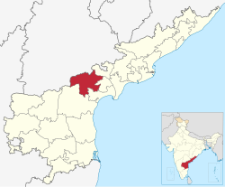
Palnadu district is a district in coastal Andhra Region in the Indian state of Andhra Pradesh. With Narasaraopet as its administrative headquarters, it was formed on 04 April 2022 to become one of the resultant twenty-six districts The district would be formed from Gurazala, Sattenapalli and Narasaraopet revenue divisions from Guntur district.[2][3][4][5] The district covers most of the Palnadu region.
Palnadu district | |
|---|---|
District of Andhra Pradesh | |
     Clockwise from top-left: Dhyana Buddha statue in Amaravati, Lakshmi Channakeshava Swami Temple in Macherla, Pelicans in Uppalapadu Bird Sanctuary, Ethipothala Falls, Buddhist monuments in Anupu | |
 | |
| Country | |
| State | |
| Region | Coastal Andhra |
| Headquarters | Narasaraopeta |
| Mandals | 28 |
| Government | |
| • District collector | Sri Siva Sankar Lotheti IAS Collector & District Magistrate |
| • SP | Sri Y. Ravi Sankara Reddy, I.P.S. |
| • Lok Sabha constituencies | Narasaraopeta |
| • MP | Lavu Sri Krishna Devarayalu |
| • Assembly constituencies | 07 |
| Area | |
| • Total | 7,298 km2 (2,818 sq mi) |
| Population (2011)[1] | |
| • Total | 2,041,723 |
| • Density | 280/km2 (720/sq mi) |
| Time zone | UTC+05:30 (IST) |
| Website | palnadu |

Boundaries
This district is bounded by Suryapet district and Nalgonda district in Telangana state at North. And surrounded by South of Bapatla district,West of Prakasam district And East of Guntur district.
Land Utilization
The total Geographical area of the District is 7,30,123 Hectares covered by forest is 1,50,759 Hectares. The net area sown is 3,15,650 Hectares. The total cropped area in the District is 3,47,114 Hectares. The area sown more than once during the year is 31,464 Hectares.
Natural and Mineral Resources
The district is rich in mineral resources. The principal minerals available are limestone, lime Lime Stonekankar, Napa slabs, Copper and Lead. Lime stone is being utilised by the cement factories of Macherla. There are copper mines at Agnigundala of Ipur Mandal.
Climate
The Normal Rainfall of the District is 775.3 M.M. The climate is Generally warm in Summer and the heat is very severe in Rentachintala Mandal, where the maximum temperature in the State is recorded.
Demographics
At the time of the 2011 census, the district had a population of 20,41,723. Scheduled Castes and Scheduled Tribes made up 3,75,554 (18.39%) and 1,42,944 (7.00%) of the population respectively.[1]: 77–82
At the time of the 2011 census, 87.12% of the population spoke Telugu, 9.90% Urdu and 2.41% Lambadi as their first language.[7]
Administrative divisions
The district has three revenue divisions, namely Gurajala, Sattenapalle and Narasaraopeta, each headed by a sub collector. These revenue divisions are divided into 28 mandals. The district consists of one municipal corporation. Narasaraopeta city is the only municipal corporation.
Politics
There are one parliamentary and seven assembly constituencies in Palnadu district. The parliamentary constituencies are
- Narasaraopet (Lok Sabha constituency)
The assembly constituencies are[8]
| Constituency number | Name | Reserved for (SC/ST/None) |
Parliament |
|---|---|---|---|
| 85 | Pedakurapadu | None | Narasaraopet Lok Sabha constituency |
| 96 | Chilakaluripet | None | Narasaraopet Lok Sabha constituency |
| 97 | Narasaraopet | None | Narasaraopet Lok Sabha constituency |
| 98 | Sattenapalle | None | Narasaraopet Lok Sabha constituency |
| 99 | Vinukonda | None | Narasaraopet Lok Sabha constituency |
| 100 | Gurajala | None | Narasaraopet Lok Sabha constituency |
| 101 | Macherla | None | Narasaraopet Lok Sabha constituency |
Mandals
There are 10 mandals in Gurazala division, 9 mandals each in Sattenapalle and Narasaraopeta divisions. The 28 mandals under their revenue divisions are listed below:[9]
Cities and towns
Largest cities or towns in Palnadu District As per the 2011 Census | |||||||||
|---|---|---|---|---|---|---|---|---|---|
| Rank | Division | Pop. | |||||||
 Narasaraopet |
1 | Narasaraopet | Narasaraopet Division | 117,489 | |||||
| 2 | Chilakaluripet | Narasaraopet Division | 101,398 | ||||||
| 3 | Piduguralla | Gurazala Division | 63,103 | ||||||
| 4 | Vinukonda | Narasaraopet Division | 62,550 | ||||||
| 5 | Macherla | Gurazala Division | 57,290 | ||||||
| 6 | Sattenapalle | Sattenapalle Division | 56,721 | ||||||
| 7 | Dachepalli | Gurazala Division | 36,280 | ||||||
| 8 | Gurazala | Gurazala Division | 30,464 | ||||||
| 9 | [[{{{city_9}}}]] | [[{{{div_9}}}]] | {{{pop_9}}} | ||||||
| 10 | [[{{{city_10}}}]] | [[{{{div_10}}}]] | {{{pop_10}}} | ||||||
| S.No. | City / Town | Civic Status of Town | Municipality
Formation Year |
2011 Census
Population |
2001 Census
Population |
1991 Census
Population |
1981 Census
Population |
1971 Census
Population |
1961 Census
Population |
1951 Census
Population |
|---|---|---|---|---|---|---|---|---|---|---|
| 1 | Narsaraopeta | Municipality Grade - 1 | 1915 | 117,489 | 95,349 | 88,726 | 67,032 | 43,467 | 29,744 | 22,243 |
| 2 | Chilakaluripeta | Municipality Grade - 1 | 1964 | 101,398 | 91,656 | 79,142 | 61,645 | 41,543 | 22,666 | 11,487 |
| 3 | Piduguralla | Municipality Grade - 2 | 2005 | 63,103 | 50,127 | 35,040 | 20,889 | 12,080 | -- | -- |
| 4 | Vinukonda | Municipality Grade - 2 | 2005 | 62,550 | 52,519 | 34,607 | 24,238 | 16,259 | 11,347 | 10,065 |
| 5 | Macherla | Municipality Grade - 2 | 1983 | 57,290 | 49,221 | 43,987 | 30,719 | 21,014 | 14,797 | 5,868 |
| 6 | Sattenapalle | Municipality Grade - 2 | 1984 | 56,721 | 51,404 | 45,442 | 33,000 | 24,216 | 17,495 | 15,048 |
| 7 | Dachepalli | Municipality Grade - 2 | 2021 | 36,280 | -- | -- | -- | -- | -- | -- |
| 8 | Gurajala | Municipality Grade - 2 | 2021 | 30,464 | -- | -- | -- | -- | -- | -- |
Note -
- Dachepalli Nagar Panchayat includes Dachepalli and Nadikudi.
- Gurazala Nagar Panchayat includes Gurazala and Jangamaheswaram.
| S.No | Town | Civic Status of Town | 2011 Census
Population |
|---|---|---|---|
| 1 | Ipur | Grama Panchayat | 5,935 |
| 2 | Talluru. [Krosur] | Grama Panchayat | 4,217 |
| 3 | Rajupalem | Grama Panchayat | 4,139 |
Notable people
- Kasu Brahmananda Reddy, former Chief Minister, Central Home Minister and Governor
- Vavilala Gopalakrishnayya, journalist and he was elected to the assembly
- Palanati Brahmanaidu, Palnadu Kingdom
- Nayakuralu Nagamma, Palnadu Kingdom
- Kaneganti Hanumanthu, freedom fighter
- Gurram Jashuva , Poet
References
- "District Census Hand Book – Guntur" (PDF). Census of India. Registrar General and Census Commissioner of India.
- Raghavendra, V. (26 January 2022). "With creation of 13 new districts, AP now has 26 districts". The Hindu. ISSN 0971-751X. Archived from the original on 26 January 2022. Retrieved 26 January 2022.
- "AP issues draft gazette notification on 26 districts". Deccan Chronicle. 26 January 2022. Archived from the original on 29 January 2022. Retrieved 11 February 2022.
- "New districts to come into force on April 4". The Hindu. 30 March 2022. Retrieved 31 March 2022.
{{cite web}}: CS1 maint: url-status (link) - "కొత్త జిల్లా తాజా స్వరూపం". Eenadu.net (in Telugu). 31 March 2022. Retrieved 31 March 2022.
{{cite web}}: CS1 maint: url-status (link) - "Population by Religion - Andhra Pradesh". censusindia.gov.in. Office of the Registrar General & Census Commissioner, India. 2011.
- "Table C-16 Population by Mother Tongue: Andhra Pradesh". Census of India. Registrar General and Census Commissioner of India.
- "District-wise Assembly-Constituencies". ceoandhra.nic.in.
- "Here's How the New AP Map Looks Like After Districts Reorganization". Sakshi. 3 April 2022. Retrieved 3 May 2022.
{{cite web}}: CS1 maint: url-status (link)
Capital: Amaravati | |||
| Topics |
| ||
| Regions | |||
| Districts |
| ||
| Million-plus cities | |||
| Cities (population over 1 lakh) |
| ||
| Tourism |
| ||
| History |
| ||
| Related lists |
| ||
| |||
Другой контент может иметь иную лицензию. Перед использованием материалов сайта WikiSort.org внимательно изучите правила лицензирования конкретных элементов наполнения сайта.
WikiSort.org - проект по пересортировке и дополнению контента Википедии