world.wikisort.org - India
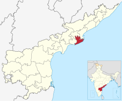
Dr. B. R. Ambedkar Konaseema district,[2] is a district in Coastal Andhra between the tributaries of the Godavari river in the Konaseema region in the Indian state of Andhra Pradesh. It was carved out of East Godavari district on 4 April 2022 by the Andhra Pradesh government. Amalapuram is the district headquarters and the largest city. It is named after B. R. Ambedkar.[3]
This article has multiple issues. Please help improve it or discuss these issues on the talk page. (Learn how and when to remove these template messages)
|
Konaseema district | |
|---|---|
District of Andhra Pradesh | |
| Dr. B. R. Ambedkar Konaseema district | |
     Clockwise from top-left: Bhimeswara temple at Draksharama, Crop fields in Yeditha, Street of Amalapuram, Antarvedi Beach, Gummileru Jain Temple | |
 | |
| Coordinates: 16.6°N 82.0°E | |
| Country | |
| State | |
| Region | Coastal Andhra |
| Formed | 4 April 2022 |
| Founded by | Government of Andhra Pradesh |
| Named for | B. R. Ambedkar |
| Headquarters | Amalapuram |
| Government | |
| • District collector | Sri Himanshu Shukla IAS Collector & District Magistrate |
| • Lok Sabha constituencies | Amalapuram |
| • MP | Chinta Anuradha |
| • Assembly constituencies | 07 |
| Area | |
| • Total | 2,081.2 km2 (803.6 sq mi) |
| Population (2011)[1] | |
| • Total | 1,719,093 |
| • Density | 830/km2 (2,100/sq mi) |
| Languages | |
| • Official | Telugu |
| Time zone | UTC+05:30 (IST) |
| Website | konaseema |
Geography
Konaseema is located in the delta of the Godavari river. It is largely agricultural in nature, with lush green paddy fields. There are some Mangrove forests in the northeast of the district.[4] It lies in between the two branches of Godavari river. The Godavari divides into two branches (i.e. Gautami and Vasishtha) and forms a three-cornered Island that was previously called as Nagaram during the Mughal times and the land is very fertile.[5]
This district is surrounded by north of East Godavari district, south of Bay of Bengal, east of Kakinada district and west of West Godavari district.[citation needed]
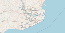
Administrative divisions
The district has three revenue divisions, namely Amalapuram, Kothapeta and Ramachandrapuram, each headed by a sub collector. These revenue divisions are divided into 22 mandals. The district consists of one municipal corporation, Amalapuram.[6]
Mandals
There are 10 mandals in Amalapuram revenue division, 7 in Kothapeta revenue division[7] and 5 in Ramachandrapuram revenue division. The 22 mandals under their revenue divisions are listed below:[6]
| # | Amalapuram division | Kothapeta division | Ramachandrapuram division |
|---|---|---|---|
| 1 | Mummidivaram | Atreyapuram | Ramachandrapuram |
| 2 | Island Polavaram | Alumuru | Gangavaram |
| 3 | Katrenikona | Ravulapalem | Mandapeta |
| 4 | Amalapuram | Kothapeta | Rayavaram |
| 5 | Uppalaguptam | Patha Gannavaram | Kapileswarapuram |
| 6 | Allavaram | Ambajipeta | |
| 7 | Razole | Ainavilli | |
| 8 | Malikipuram | ||
| 9 | Sakhinetipalli | ||
| 10 | Mamidikuduru |
Cities and towns
This section does not cite any sources. (January 2022) |
Largest cities or towns in East Godavari district As per the 2011 Census | |||||||||
|---|---|---|---|---|---|---|---|---|---|
| Rank | Division | Pop. | |||||||
| 1 | Mandapeta | Ramachandrapuram Division | 65,406 | ||||||
| 2 | Amalapuram | Amalapuram Division | 53,231 | ||||||
| 3 | Ramachandrapuram | Ramachandrapuram Division | 43,657 | ||||||
| 4 | Mummidivaram | Amalapuram Division | 25,355 | ||||||
| 5 | [[{{{city_5}}}]] | [[{{{div_5}}}]] | {{{pop_5}}} | ||||||
| 6 | [[{{{city_6}}}]] | [[{{{div_6}}}]] | {{{pop_6}}} | ||||||
| 7 | [[{{{city_7}}}]] | [[{{{div_7}}}]] | {{{pop_7}}} | ||||||
| 8 | [[{{{city_8}}}]] | [[{{{div_8}}}]] | {{{pop_8}}} | ||||||
| 9 | [[{{{city_9}}}]] | [[{{{div_9}}}]] | {{{pop_9}}} | ||||||
| 10 | [[{{{city_10}}}]] | [[{{{div_10}}}]] | {{{pop_10}}} | ||||||
| S.No. | City / Town | Municipality
formation year |
No. of
Wards |
Civic status
of municipal body |
2011 census
population |
2001 census
population |
1991 census
population |
1981 census
population |
1971 census
population |
1961 census
population |
1951 census
population |
|---|---|---|---|---|---|---|---|---|---|---|---|
| 1 | Mandapeta | 1958 | 30 | Municipality Grade - 2 | 65,406 | 51,638 | 42,453 | 33,499 | 25,316 | 19,766 | 15,139 |
| 2 | Amalapuram | 1948 | 30 | Municipality Grade - 1 | 53,231 | 51,444 | 46,029 | 38,999 | 30,518 | 24,063 | 21,117 |
| 3 | Ramachandrapuram | 1959 | 28 | Municipality Grade - 2 | 43,657 | 41,370 | 36,788 | 30,902 | 23,685 | 18,778 | 15,381 |
| 4 | Mummidivaram | 2011 | 20 | Nagar Panchayat | 25,355 | -- | -- | -- | -- | -- | -- |
| S.No. | Town | Civic Status of Town | 2011 Census
Population |
|---|---|---|---|
| 1 | Tallarevu | Grama panchayat | 24,550 |
| 2 | Kothapeta | Grama panchayat | 24,539 |
| 3 | Rayavaram | Grama panchayat | 17,361 |
| 4 | Razole | Grama panchayat | 13,597 |
| 5 | Alamur | Grama panchayat | 9,723 |
| 6 | P.Gannavaram | Grama panchayat | 9,459 |
| 7 | Korukonda | Grama panchayat | 9,228 |
| 8 | Rangampeta | Grama panchayat | 7,983 |
| S.No. | Town | Civic status of town | 2011 census
population |
|---|---|---|---|
| 1 | Bandaru Lanka [Amalapuram] | Census town | 11,470 |
| 2 | Arempudi [Sankhavaram] | Census town | 5,073 |
Politics
There are one parliamentary and seven assembly constituencies in the Konaseema district. The parliamentary constituency is Amalapuram (Lok Sabha constituency). The assembly constituencies are[8]
| Constituency number | Name | Reserved for (SC/ST/None) |
Parliament |
|---|---|---|---|
| 42 | Ramachandrapuram | None | Amalapuram (Lok Sabha constituency) |
| 43 | Mummidivaram | None | Amalapuram (Lok Sabha constituency) |
| 44 | Amalapuram | SC | Amalapuram (Lok Sabha constituency) |
| 45 | Razole | SC | Amalapuram (Lok Sabha constituency) |
| 46 | Gannavaram | SC | Amalapuram (Lok Sabha constituency) |
| 47 | Kothapeta | None | Amalapuram (Lok Sabha constituency) |
| 48 | Mandapeta | None | Amalapuram (Lok Sabha constituency) |
Demographics
At the time of the 2011 census, Konaseema district had a population of 1,719,093. Scheduled Castes and Scheduled Tribes made up 427,130 (24.85%) and 13,481 (0.78%) respectively.[1]
Telugu is the predominant language, spoken by 99.11% of the population.[10]
Culture
The region has a varied folk culture. Being in the heart of the Godavari Delta, Konaseema has a large population of Brahmins, Kapus & Rajus, Kammas who were the erstwhile owners of most of the land. In fact, Konaseema is one of the only two regions in India, apart from Kerala, where there is still a large community still practising traditional Shrauta rites, which have largely fallen out of use in the rest of India, making it a favoured destination for Scholars seeking to understand ancient Vedic culture.[11]
The villagers also have a varied folk culture with their own regional gods. Most of the Dalits, like in most of Coastal Andhra, are Christians, both Catholic and Protestant.[12]
Transportation
Konaseema District is connected by National Highway NH216. Public state transport operates, APSRTC bus services from district headquarters Amalapuram to Rajahmundry, Razole, Kakinada, Annavaram, Visakhapatnam, Ravulapalem, Tanuku, Eluru, Palakollu , Tuni, Hyderabad, Vijayawada, Srikakulam, Tekkali, Ichapuram, Vizianagaram , Narsapuram, Bhimavaram, Machilipatnam, Srisailam, Guntur, Tirupati.[citation needed]
Nearest railway stations
Rajahmundry railway station, Palakollu railway station, Narsapuram railway station, Bhimavaram Junction railway station, Bhimavaram Town Halt railway station are the nearest railway stations.[13]
Proposed railway line
Kakinada - Kotipalli - Narsapur railway line is under construction and a bridge over the Godavari river is being constructed.[14]
This railway line makes a station at Amalapuram.[15][16]
See also
- Konaseema district protest
References
- "Demography | Dr. B. R. Ambedkar Konaseema District | India".
- "G.O. on naming Konaseema district after Dr. B.R. Ambedkar issued". The Hindu. 3 August 2022. ISSN 0971-751X. Retrieved 13 September 2022.
- Janyala, Sreenivas (24 June 2022). "Andhra Pradesh renames newly created Konaseema district". The Indian Express. Retrieved 24 June 2022.
- "Konaseema | PDF | Agriculture | Nature". Scribd. Retrieved 6 June 2022.
- Charles Alfred Browne (1843). Alfred Radford Symonds (ed.). "An Introduction to the Geography and History of India, and the Countries Adjacent". P.R. Hunt. p. 188.
- "MANDALS | Dr. B. R. Ambedkar Konaseema District | India". Retrieved 7 April 2022.
- "AP cabinet approves two new revenue divisions". Deccan Chronicle. Retrieved 1 May 2022.
{{cite web}}: CS1 maint: url-status (link) - "District-wise Assembly-Constituencies". ceoandhra.nic.in.
- "Population by Religion - Andhra Pradesh". censusindia.gov.in. Office of the Registrar General & Census Commissioner, India. 2011.
- "Census of India Website : Office of the Registrar General & Census Commissioner, India". www.censusindia.gov.in.
- Knipe, David M. (1 April 2015). Vedic Voices: Intimate Narratives of a Living Andhra Tradition. Oxford University Press. doi:10.1093/acprof:oso/9780199397686.001.0001. ISBN 978-0-19-939768-6.
- "When the Caregiver Is Also a Survivor", Touched, 1517 Media, pp. 76–92, 3 March 2020, doi:10.2307/j.ctvp7d5f8.10, S2CID 240764530, retrieved 6 June 2022
- "Nearest Railway Stations to Konaseema Andhra Pradesh East Godavari". trainspy.com. Retrieved 7 June 2022.
- "Kotipalli-Narasapur railway line project work in Andhra Pradesh on track". The New Indian Express. Retrieved 13 April 2022.
- Naidu, T. Appala (13 February 2022). "'Release State share to complete Kotipalli-Narsapur railway project', demands BJP MP GVL". The Hindu. ISSN 0971-751X. Retrieved 13 April 2022.
- "త్వరలోనే కోనసీమకు రైలు కూత". Sakshi (in Telugu). 27 February 2016. Retrieved 13 April 2022.
Capital: Amaravati | |||
| Topics |
| ||
| Regions | |||
| Districts |
| ||
| Million-plus cities | |||
| Cities (population over 1 lakh) |
| ||
| Tourism |
| ||
| History |
| ||
| Related lists |
| ||
| |||
Другой контент может иметь иную лицензию. Перед использованием материалов сайта WikiSort.org внимательно изучите правила лицензирования конкретных элементов наполнения сайта.
WikiSort.org - проект по пересортировке и дополнению контента Википедии