world.wikisort.org - India
Tirupati district (![]() pronunciation (help·info)) is one of the twenty-six districts in the Indian state of Andhra Pradesh and one of the eight districts in the Rayalaseema region of the Andhra Pradesh state. The district headquarters is located at Tirupati city. Tirupati district is known for its numerous historic temples, including the Hindu shrine of Tirumala Venkateswara Temple, Sri Kalahasteeswara temple and many others.The district is also home to Satish Dhawan Space Centre (formerly Sriharikota Range), a rocket launch centre located in Sriharikota and operated by Indian Space Research Organisation (ISRO). The river Swarnamukhi flows through Srikalahasti and joins with the Bay of Bengal in this district. Industries include groundnuts and paddy fields.
pronunciation (help·info)) is one of the twenty-six districts in the Indian state of Andhra Pradesh and one of the eight districts in the Rayalaseema region of the Andhra Pradesh state. The district headquarters is located at Tirupati city. Tirupati district is known for its numerous historic temples, including the Hindu shrine of Tirumala Venkateswara Temple, Sri Kalahasteeswara temple and many others.The district is also home to Satish Dhawan Space Centre (formerly Sriharikota Range), a rocket launch centre located in Sriharikota and operated by Indian Space Research Organisation (ISRO). The river Swarnamukhi flows through Srikalahasti and joins with the Bay of Bengal in this district. Industries include groundnuts and paddy fields.
This article needs additional citations for verification. (August 2022) |
Tirupati district | |
|---|---|
District of Andhra Pradesh | |
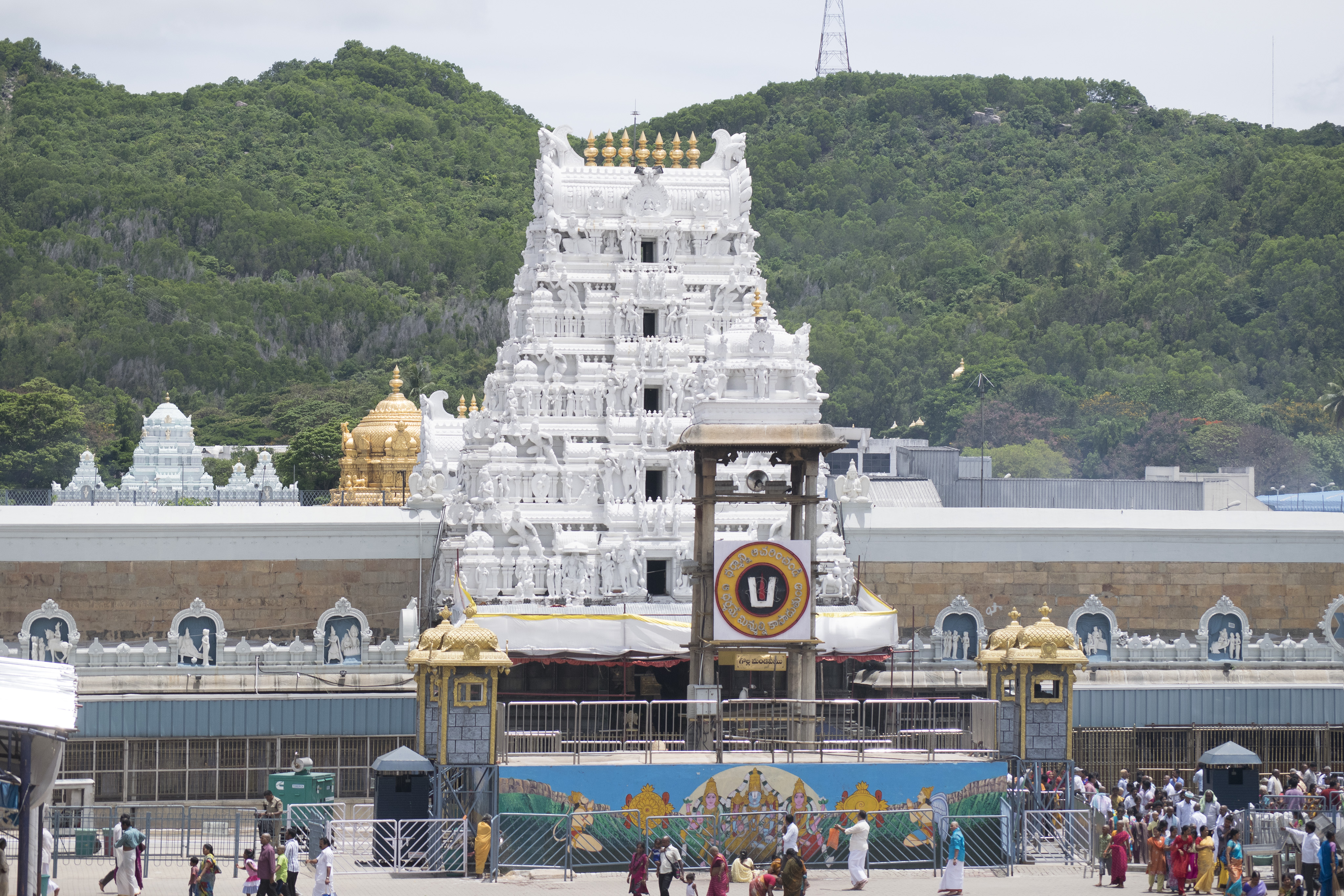
 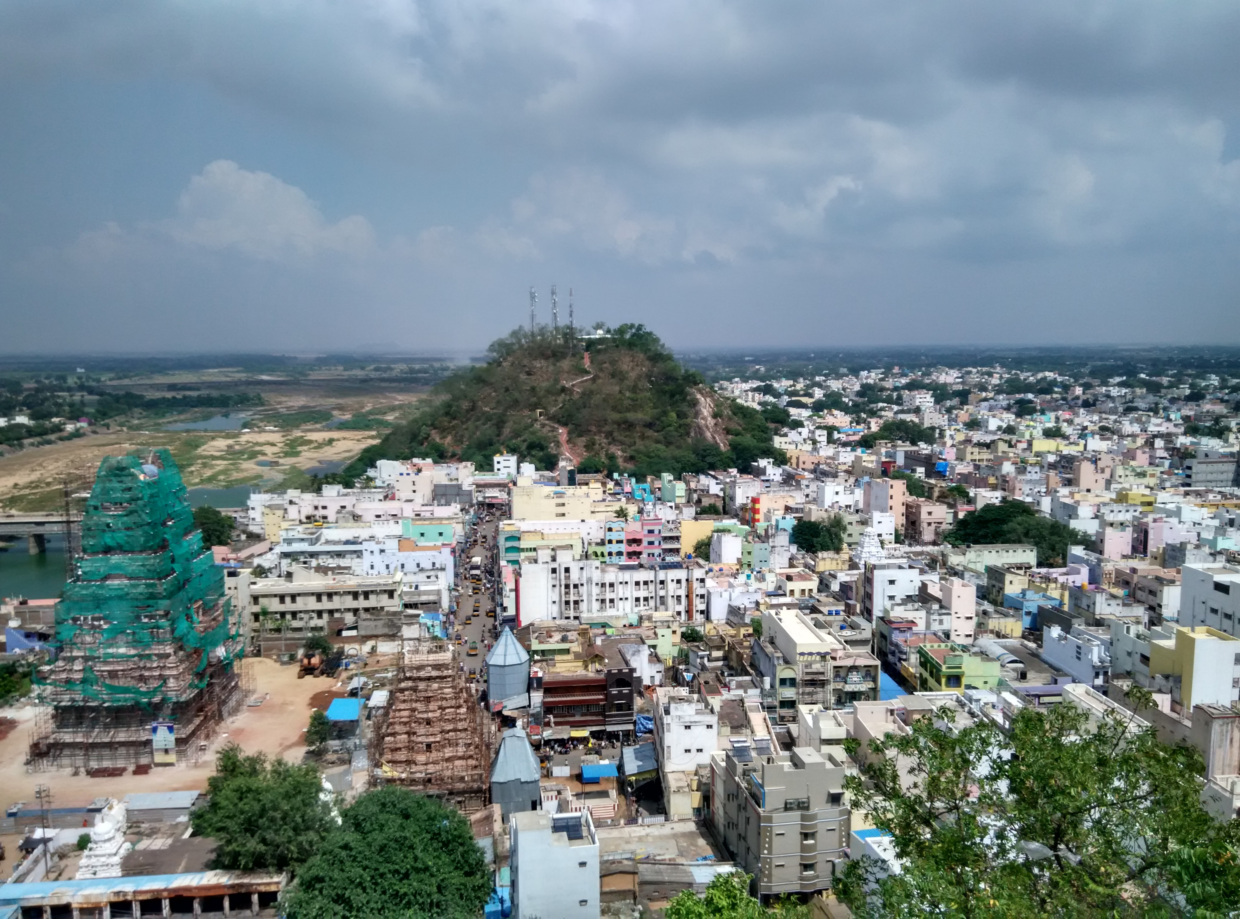      Clockwise from top-left:
Tirumala Sri Venkateshwara swamy Temple, View of Srikalahasti from Kanappa Hill, Chandragiri Fort,Liftoff from Satish Dhawan Space Centre at Sriharikota, Sri Venkateswara National Park, View of Pulicat Lake,Chengalamma Parameshwari Temple near Sri City | |
 Location of Tirupati district in Andhra Pradesh | |
| Coordinates: 13.6°N 79.4°E | |
| Country | |
| State | |
| Region | Rayalaseema |
| Formed | 4 April 2022 |
| Founded by | Government of Andhra Pradesh |
| Headquarters | Tirupati |
| Administrative Divisions |
|
| Government | |
| • District collector | K. Venkata Ramana Reddy IAS |
| • SP | Sri P. Parameshwar |
| • Lok Sabha constituencies | Tirupati
Lok Sabha list |
| • Assembly | Assembly list |
| Area | |
| • Total | 8,231 km2 (3,178 sq mi) |
| Population | |
| • Total | 2,196,984 |
| • Density | 270/km2 (690/sq mi) |
| Languages | |
| • Official | Telugu |
| Time zone | UTC+5:30 (IST) |
| Postal Index Number | 517XXX, 524XXX |
| Website | tirupati |
The district is an educational hub and has central and state universities and institutes including IIT Tirupati, Sri Venkateswara University, National Sanskrit University, IISER Tirupati. The district is home to Sri City, one of the leading special economic zone (SEZ) in India with total investments of 4 billion USD and over two hundred companies from 28 countries. Sri City is considered a major industrial hub and SEZ in India.

Geography
Tirupati district is located between the Northern Latitudes of 13°21′54″ and 14°30′40″ and between the Eastern Longitudes 79°5′42″ and 80°4′10″. It is bordered by SPSR Nellore district to the North, Chittoor and Annamayya districts to the west and Tiruvallur district of Tamil Nadu to south and Bay of Bengal to the east. The river Swarnamukhi flows from Srikalahasti in Tirupati district, and the major part of Pulicat Lake is in this district.
Etymology
The district derived its name from its main city, Tirupati. In Dravidian translation, tiru means sacred or Lakshmi and pati means abode or husband.[4][5][6]
History
On 26 January 2022, Balaji district was nominated as one of the twenty-six districts in a 13-district Andhra Pradesh, pending a final notification to be issued by the government of Andhra Pradesh. The district would be formed from Tirupati revenue division, from former Chittoor district, Gudur and Naidupeta revenue divisions of former Nellore district.[7] The name was later changed to Tirupati district and came into existence on 4 April 2022, with Gudur, Sullurupeta revenue divisions from Nellore district and Srikalahasti and Tirupati divisions from Chittoor district, with Srikalahasti division being newly created.[8][9][10]
Demographics
At the time of the 2011 census, Tirupati district had a population of 21,96,984. Scheduled Castes and Scheduled Tribes make up 5,19,388 (23.64%) and 1,70,779 (7.77%) of the population respectively.[2]: 92–96 [3]: 82–87
At the time of the 2011 census, 88.00% of the population spoke Telugu, 6.50% Tamil and 3.64% Urdu as their first language.[12]
Administrative divisions
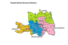
The district has four revenue divisions, Gudur, Srikalahasti, Sullurupeta and Tirupati and has one administrative headquarters Tirupati, each headed by a sub-collector. These revenue divisions are divided into 34 mandals. The district has one municipal corporation, Tirupati city. The district has six municipalities at Gudur, Srikalahasti, Naidupeta, Sullurpeta, Puttur and Venkatagiri.This district also comprises 822 Gram Panchayats and 1107 villages.[1]
Mandals
There are 9 mandals each in Tirupati division and Sullurupeta divisions, 8 mandals each in Gudur division and Srikalahasti divisions. The 34 mandals under their revenue divisions are listed below:[13]
Cities and towns
The district has one municipal corporation at Tirupati city, and six municipalities at Srikalahasti, Gudur, Naidupeta, Sullurpeta, Puttur and Venkatagiri. This district also has many census towns, 822 gram panchayats and 1107 villages.[1][non-primary source needed]
Largest cities or towns in Tirupati district As per the 2011 Census | |||||||||
|---|---|---|---|---|---|---|---|---|---|
| Rank | Division | Pop. | |||||||
 Tirupati |
1 | Tirupati | Tirupati division | 4,61,905 |  Gudur | ||||
| 2 | Srikalahasti | Srikalahasti division | 80,056 | ||||||
| 3 | Gudur | Gudur division | 74,047 | ||||||
| 4 | Yerpedu | Srikalahasti division | 58,403 | ||||||
| 5 | Puttur | Tirupati division | 54,092 | ||||||
| 6 | Satyavedu | Sullurupeta division | 52,979 | ||||||
| 7 | Venkatagiri | Gudur division | 52,688 | ||||||
| 8 | Sullurpeta | Sullurupeta division | 45,782 | ||||||
| 9 | Naidupeta | Sullurupeta division | 45,055 | ||||||
| 10 | Pakala | Tirupati division | 28,556 | ||||||
| S.No. | Name | Civic status | Revenue division |
Population (2011 census) |
|---|---|---|---|---|
| 1 | Tirupati | Municipal Corporation | Tirupati | 2,87,035 |
| 2 | Srikalahasti | Municipality Grade - 1 | Srikalahasti | 80,056 |
| 3 | Gudur | Municipality Grade - 1 | Gudur | 74,047 |
| 4 | Yerpedu | Census Town | Srikalahasti | 58,403 |
| 5 | Puttur | Municipality Grade - 3 | Tirupati | 54,092 |
| 6 | Satyavedu | Census Town | Sullurupeta | 52,979 |
| 7 | Venkatagiri | Municipality Grade - 3 | Gudur | 52,688 |
| 8 | Sullurupeta | Municipality Grade - 3 | Sullurupeta | 45,782 |
| 9 | Naidupeta | Municipality Grade - 3 | Sullurupeta | 45,055 |
| 10 | Pakala | Census Town | Tirupati | 28,556 |
Education
- Sri Venkateswara University
- Sri Padmavati Mahila Visvavidyalayam
- Government Institute of Ceramic Technology
- National Institute of Ocean Technology
- IIT Tirupati
- IISER Tirupati
- National Sanskrit University
- Indian Culinary Institute, Tirupati
- Sri Venkateswara Vedic University
- Sri Venkateswara Veterinary University (SVVU)
- Sri Venkateswara Institute of Medical Sciences (SVIMS)
- Sri Venkateswara Agricultural University
- Sri Venkateswara Institute of Cancer Care and Advanced Research Tata Trusts - SVICCAR Hospital
- Mohan Babu University
- Krea University
- Institute of Financial Management and Research
- Indian Institute of Information Technology, Sri City
Transport
Railways
This district has the third biggest railway station in Andhra Pradesh. Tirupati railway station is among the busiest railway stations of India, connected with all major cities of India. It is on the Renigunta-Katpadi railway line.
Tirupati city has five railway stations:
Tirupati district also has a major railway station at Gudur junction. The other important railway stations in the district are Srikalahasti railway station, Pakala junction, Puttur and Sullurupeta railway station.

Roadways
National Highway 71 connecting Madanapalle and Nayudupeta Via Pileru and NH 716 connecting Chennai in Tamil Nadu passes through the district. National Highway 16, a part of the Golden Quadrilateral connecting Kolkata-Chennai passes through Sullurpeta and Gudur towns in the district. A new six lane express way has been constructed between Tirupati and Bangalore via Chittoor.
Waterways
Dugarajapatnam Port is a proposed port in the district.[14]
Airways

Sri Venkateswara Airport, the second-largest airport in Andhra Pradesh, is located 15 km (9.3 mi) from the Tirupati city centre and has daily flights to Coimbatore, Hyderabad, Kolkata, Bangalore, Mumbai, New Delhi, Kadapa, Rajahmundry, kolhapur,Vijayawada, Madurai, Tiruchirapalli, Pune, Shirdi, Belgaum, Hubli, Gulbarga, Visakhapatnam.
The closest international airport is Chennai International Airport which is 130 km (81 mi) from Tirupati. Tirupati Airport is being upgraded to an international airport. The new terminal was inaugurated on 22 October 2015.[15]
Notable people
- M. A. Ayyangar, first deputy speaker and second Speaker of Lok Sabha
- V. Nagayya, actor
- D. K. Adikesavulu Naidu, Member of Parliament
- N. Chandrababu Naidu, Chief Minister of United Andhra Pradesh (1995–2004), and first Chief Minister of Residual State Of Andhra Pradesh (2014–2019)
- N. Janardhana Reddy, 12th Chief Minister of Andhra Pradesh[16]
- Bhumana Karunakar Reddy, Tirupati, MLA
- Madhurantakam Rajaram, writer, Sahitya Akademi Award winner
- Raj Reddy, Computer Scientist and winner of Turing Award
- Roja Selvamani, actress, Minister for Tourism, Culture and Youth Advancement of Andhra Pradesh
- Shafi (actor), film actor.
Politics
There are one parliamentary and seven assembly constituencies in Tirupati district. The parliamentary constituency is Tirupati (Lok Sabha constituency).
The assembly constituencies are:[17]
| Constituency number | Name | Reserved for (SC/ST/None) |
Parliament |
|---|---|---|---|
| 167 | Tirupati | None | Tirupati (Lok Sabha constituency) |
| 121 | Sullurpeta | SC | Tirupati (Lok Sabha constituency) |
| 122 | Venkatagiri | None | Tirupati (Lok Sabha constituency) |
| 120 | Gudur | SC | Tirupati (Lok Sabha constituency) |
| 168 | Srikalahasti | None | Tirupati (Lok Sabha constituency) |
| 169 | Satyavedu | SC | Tirupati (Lok Sabha constituency) |
| 166 | Chandragiri | None | Tirupati (Lok Sabha constituency) |
References
- "Tirupati District: At a glance". tirupati.ap.gov.in. Retrieved 4 April 2022.
- "District Census Hand Book - Nellore" (PDF). Census of India. Registrar General and Census Commissioner of India.
- "District Census Hand Book - Chittoor" (PDF). Census of India. Registrar General and Census Commissioner of India.
- Oppert, Gustav Salomon (8 June 2017). On the Original Inhabitants of Bharatavarsa or India. BoD – Books on Demand. ISBN 9789925082193.
- "Full text of "On the original inhabitants of Bharatavarsa or India"". archive.org. 1893. Retrieved 18 November 2016.
- "Index of /NASD/4a7f1db4-5792-415c-be79-266f41eef20a/upgrade-archive-06-14-2007/data/upload-allbooks/disk 3/Jan N/ENGLISH/The_Dravidians_/TXT". tera-3.ul.cs.cmu.edu. Retrieved 18 November 2016.
- Raghavendra, V. (26 January 2022). "With creation of 13 new districts, AP now has 26 districts". The Hindu. ISSN 0971-751X. Archived from the original on 26 January 2022. Retrieved 26 January 2022.
- "New districts to come into force on April 4". The Hindu. 30 March 2022. Retrieved 31 March 2022.
{{cite web}}: CS1 maint: url-status (link) - Rangarajan, A. d (3 April 2022). "Andhra Pradesh: Govt. agrees to name new district 'Tirupati'". The Hindu. ISSN 0971-751X. Retrieved 7 April 2022.
- "కొత్త జిల్లా తాజా స్వరూపం". Eenadu.net (in Telugu). 31 March 2022. Retrieved 31 March 2022.
{{cite web}}: CS1 maint: url-status (link) - "Population by Religion - Andhra Pradesh". censusindia.gov.in. Office of the Registrar General & Census Commissioner, India. 2011.
- "Table C-16 Population by Mother Tongue: Andhra Pradesh". Census of India. Registrar General and Census Commissioner of India.
- Sasidhar, B. M. (4 April 2022). "Chittoor, Tirupati, Annamayya districts formed as part of rejig". www.thehansindia.com. Retrieved 6 April 2022.
- "Decks cleared for Dugarajapatnam port". The Times of India.
- "Tirupati International Airport inauguration on Vijaya Dasami". The hindu. Retrieved 12 October 2015.
- "Former Chief Minister NJR Dead". The New Indian Express. 10 May 2014. Retrieved 21 April 2022.
- "District-wise Assembly-Constituencies". ceoandhra.nic.in.
External links
Capital: Amaravati | |||
| Topics |
| ||
| Regions | |||
| Districts |
| ||
| Million-plus cities | |||
| Cities (population over 1 lakh) |
| ||
| Tourism |
| ||
| History |
| ||
| Related lists |
| ||
| |||
Places adjacent to Tirupati district | ||||||||||||||||
|---|---|---|---|---|---|---|---|---|---|---|---|---|---|---|---|---|
| ||||||||||||||||
Другой контент может иметь иную лицензию. Перед использованием материалов сайта WikiSort.org внимательно изучите правила лицензирования конкретных элементов наполнения сайта.
WikiSort.org - проект по пересортировке и дополнению контента Википедии