world.wikisort.org - India
YSR Kadapa district (officially: YSR district;[5] formerly: Cuddapah district[1]: 19 ) is one of the twenty six districts in the Indian state of Andhra Pradesh. On 19 August 2005 nomenclature of “Cuddapah” has been changed as “Kadapa” by the Government of A.P. It was renamed as Y.S.R District during the year 2010, in honour of Y. S. Rajasekhara Reddy, commemorating the former chief minister of united Andhra Pradesh.[6] It is also one of the eight districts in the Rayalaseema region. Kadapa is the administrative headquarters for this district.[7]
This article needs additional citations for verification. (June 2022) |
Kadapa district | |
|---|---|
District of Andhra Pradesh | |
| YSR district | |
     Clockwise from top-left: Kodanda Rama Temple in Vontimitta, Pulivendula main street, Chennakeshava temple at Pushpagiri, Hills in Sri Lankamalleswara Wildlife Sanctuary, Jamia Masjid and Madhavaraya Swamy Temple at Gandikota | |
| Nickname: Gadapa | |
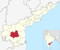 Location of YSR district in Andhra Pradesh | |
| Coordinates: 14°28′N 78°49′E | |
| Country | |
| State | |
| Region | Rayalaseema |
| Named for | Y. S. Rajasekhara Reddy |
| Headquarters | Kadapa |
| Administrative Divisions |
|
| Government | |
| • District collector | V. Vijay Ramaraju IAS |
| • Lok Sabha | Lok Sabha list |
| • Assembly | Assembly list |
| Area | |
| • Total | 11,228 km2 (4,335 sq mi) |
| • Rank | 7th |
| Population (2011)[2] | |
| • Total | 2,060,654 |
| • Rank | 18th |
| • Density | 188/km2 (490/sq mi) |
| • Rank | 21st |
| • Urban [1]: 14 | 809,290 |
| • Rural [1]: 14 | 1,251,364 |
| • Households | 706,204 |
| • Sex ratio | 985 (females per 1,000 males) |
| Languages | |
| • Official | Telugu |
| Literacy | |
| • Literates | 1716766 |
| Time zone | UTC+5:30 (IST) |
| Postal Index Number | 516xxx [3] |
| Area codes | +91–8562 |
| ISO 3166 code | IN-AP |
| Vehicle registration | AP-04 (former) AP–39 (from 30 January 2019)[4] |
| Website | kadapa |


History
Rock paintings
Paleolithic rock paintings found at Chintakunta caves[8] near Muddanur in Kadapa district are said to be the second largest group of paintings in India after Bhimbetika rock art paintings. The rock paintings with mystic figures are also found at Dappalle village[9] near Mylavaram Dam in Jammalamadugu Taluk of the district.
Prehistoric culture
Many Paleolithic sites were found in Kadapa district, as the surroundings of Jammalamadugu, Mailavaram Dam[9] and Gandikota.
Some megalithic burial sites were explored near Porumamilla, Sankhavaram and at Yellatur[10] village near Kadapa. The surroundings of Vontimitta are also noted as Megalithic cultural sites.
The section of Rayachoti consists of many documented and undocumented Megalithic sites and stone circles. A noted megalithic site is at Devandlapalli[11] in Tsundupalle taluk of the district.
Buddhism and Jainism
Kadapa has historical importance since the BC era. It was ruled by the Mauryan Empire and the Satavahana Empire (Andhras).[12] Buddhism flourished for many years along the banks of the rivers Cheyyeru and Penna. Nandalur[13] is an important Buddhist site in the district along with Tallapaka, Rajampeta, Konduru, Khazipeta in the district. Jainism also had a place in Kadapa district history; the remnants of a buried Jain temple were found at Danavulapadu[14] village on the banks of the Penna.
Medieval history
The district is part of Rayalaseema, commemorating the name of Rayulu (Kings) of the Vijayanagar Empire, who ruled the area in the 16th century. Gandikota fort located on the bank of the Penna river was the citadel of Pemmasani Nayaks, commanders of Vijayanagar army and who won the battles of Raichur and Gulbarga for the Vijayanagar kings.
The old records of the district reveal that Kadapa previously called Gadapa which translated in Telugu to threshold. The ancient village of Kadapa with its large tank and temple of Lord Venkateswara at Devuni Kadapa was convenient camping place for the myriads of pilgrims travelling to the holy shrine of Tirupathi. There was a belief that the pilgrims have to first visit Devuni Kadapa, before going to Tirupathi to pray to Saint Annamacharya and Saint Potuluri Veera Brahmam who foretold the future and advocated a classless society. The ancient temple at Vontimitta which inspired Pothana to compose Andhra Maha Bhagavatham is also in the district. In the olden days Kadapa was also called "Hiranyanagaram".
Recent historical records reveal that Jyothi village located in Siddavatam mandal has 108 Shiva lingas on the bank of the river.
Nawabs of Kadapa
| Nawab | Reign |
|---|---|
| Neknaam Khan | 1645 - 1672 |
| Abdul Nabi Khan | 1715 - 1732 |
| Abdul Alam Khan | 1756 - 1780 |
Modern history
After the Treaty of Seringapatam, the Nizam of Hyderabad acquired the district. He ceded it to the British in 1800, and in 1808 it was divided to form Kadapa (spelt Cuddapah by the British) and Bellary districts.[15]
The district headquarters were situated in Siddavatam but moved to Kadapa in 1812.[16]
Geography
Kadapa district occupies an area of 11,228 square kilometres (4,335 sq mi),[17] comparatively equivalent to Canada's Prince Patrick Island.[18] The main rivers in this district are Penna, Chitravathi, Kunderu, Papagni, Sagileru, Bahuda and Cheyyeru.
This district is surrounded by North of Nandyal district,South of Annamayya district ,East of SPSR Nellore district ,west of Sri Sathya Sai district,Anantapur district.This district is located in center of Andhra Pradesh.
Reservoirs
Kadapa district has several reservoirs, some of which are Brahmamsagar Reservoir, Mylavaram Dam Reservoir, Annamayya Project, Gandikota Reservoir.[19]
Demographics
| Year | Pop. | ±% |
|---|---|---|
| 1871 | 1,351,194 | — |
| 1881 | 1,121,038 | −17.0% |
| 1891 | 1,272,072 | +13.5% |
| 1901 | 1,291,267 | +1.5% |
| 2001 | 2,601,797 | +101.5% |
| 2011 | 2,884,524 | +10.9% |
| Source: 1871-1901[20] | ||
As of 2011[update] census, Kadapa district has a population of 2,884,524. This gives it a ranking of 132nd in India (out of a total of 640). The district has a population density of 188 inhabitants per square kilometre (490/sq mi) . Its population growth rate over the decade 2001–2011 was 10.87%. It has a sex ratio of 984 females for every 1000 males, and a literacy rate of 67.88%.
After reorganization the district had a population of 20,60,654. Scheduled Castes and Scheduled Tribes make up 3,37,860 (16.40%) and 40,994 (1.99%) of the population respectively.[2]: 80–84
At the time of the 2011 census, 84.66% of the population spoke Telugu and 14.37% Urdu as their first language.[22]
Economy

Besides its historical importance, the district has occupied an important place in the industrial map of Andhra Pradesh with its valuable mineral resources.
The Gross District Domestic Product (GDDP) of the district is ₹26,342 crore (US$3.3 billion) and contributes 5% to the Gross State Domestic Product (GSDP). For the FY 2013–14, the per capita income at current prices was ₹70,821 (US$890). The primary, secondary and tertiary sectors of the district contribute ₹6,204 crore (US$780 million), ₹6,935 crore (US$870 million) and ₹13,203 crore (US$1.7 billion) respectively.[23]
Black corson soil lands are 24%, black soil 19%, sandy soil lands 4%, red soil lands 25%. The first variety lands are very fertile, sand soil lands less so. 'Korra', orange, lime and betel leaf are the special crops. They are cultivated near river beds. Starting at Sunkesula Dam on Tungabadra river K. C. Canal flows through Kadapa and Kurnool districts providing water to 40 km2 (15 sq mi) of cultivable land. The main source of drinking water to this district is Galeru Nagari Sujala Sravanthi Project Canal.
This district is the repository of mineral wealth. As per the 1983 survey of geological survey of India 3 million tons of lead, 74,000,000 tons of barytes, and 27000 tons of asbestos deposits are there. It is estimated that 70 million tons of barytes deposits might be in Mangampet. There are clay deposits in Rajampet. This is used to make stone implements. Limestone is available in Yerraguntla. National Mineral Development Corporation is extracting asbestos in Brahman palli and barytes in Mangampet. Kadapa is also famous for its stone called "kadapa stone" used in building construction and for slabs especially in south India. In Tummalapalle, there are 49,000 tonnes of confirmed uranium deposits which are mined and processed locally.[24][25] Apart from these minerals and industries Agriculture also forms a part district economy.

Industries
In 2006 the Indian government named Kadapa district as one of the country's 250 most backward districts (out of a total of 640).[26] It is one of the thirteen districts in Andhra Pradesh currently receiving funds from the Backward Regions Grant Fund Programme (BRGF).[26]
Administrative divisions

Divisions
Kadapa district has four Revenue Divisions viz. Kadapa, Badvel, Pulivendula and Jammalamadugu divisions.[27] The district has 36 mandals under these revenue divisions.[28] It also has a Municipal Corporation of Kadapa and five municipalities namely Badvel, Mydukur, Proddatur, Pulivendula, Jammalamadugu
Mandals
The mandals are listed with respect to their revenue divisions in the following table:[27][29][30]
Before the formation of mandals, Administration was done through Taluka system. Erstwhile Talukas in Kadapa district were:
| S.No. | Erstwhile talukas in 1971 | Newly formed talukas in 1978 | New mandals formed in 1985 |
|---|---|---|---|
| 1. | Kadapa | Kadapa | Kadapa, Vallur, Chennur, Khajipeta, Chinthakommadinne, Pendlimarri, |
| 2 | Kamalapuram | Kamalapuram | Kamalapuram, Yerraguntla, Veerapunayunipalle |
| 3 | Jammalamadugu | Jammalamadugu | Jammalamadugu [part], Mylavaram, Peddamudium |
| Muddanur [10] | Muddanur, Kondapuram, Jammalamadugu [part] | ||
| 4 | Proddutur | Proddutur | Proddutur, Mydukur, Chapad, Rajupalem, Duvvur, |
| 5 | Badvel | Badvel | Badvel, Kalasapadu, Sri Avadutha kasinayana, Porumamilla, B.Kodur, Brahmamgari mattam, Gopavaram [part] |
| 6 | Sidhout | Sidhout | Sidhout, Atlur, Gopavaram, Vontimitta, Gopavaram [part] |
| 7 | Rajampeta | Rajampeta | Rajampeta, Nandalur, Penagalur |
| Kodur [11] | Kodur, Pullampeta, Chitvel, Obulavaripalle, | ||
| 8 | Rayachoty | Rayachoty | Rayachoty, Veeraballe, Sambepalle, Chinnamandem, T sundupalle |
| Lakkireddipalli[12] | Lakkireddipalle, Chakrayapeta, Ramapuram, Galiveedu | ||
| 9 | Pulivendula | Pulivendula | Pulivendula, Vempalle, Lingala, Thondur, Simhadripuram, Vemula |
Parliament constituenciy
Kadapa (Lok Sabha constituency)
Assembly constituencies
| Constituency number | Name | Reserved for (SC/ST/None) |
Parliament |
|---|---|---|---|
| 124 | Badvel | SC | Kadapa Lok Sabha constituency |
| 131 | Jammalamadugu | None | Kadapa Lok Sabha constituency |
| 126 | Kadapa | None | Kadapa Lok Sabha constituency |
| 130 | Kamalapuram | None | Kadapa Lok Sabha constituency |
| 133 | Mydukur | None | Kadapa Lok Sabha constituency |
| 132 | Proddatur | None | Kadapa Lok Sabha constituency |
| 129 | Pulivendula | None | Kadapa Lok Sabha constituency |
Cities & Towns
Largest cities or towns in Kadapa District As per the 2011 Census | |||||||||
|---|---|---|---|---|---|---|---|---|---|
| Rank | Division | Pop. | |||||||
Kadapa  Proddatur |
1 | Kadapa | Kadapa revenue division | 344,893 |  Badvel | ||||
| 2 | Proddatur | Jammalamadugu revenue division | 217,786 | ||||||
| 3 | Badvel | Badvel revenue division | 70,626 | ||||||
| 4 | Pulivendula | Jammalamadugu revenue division | 65,706 | ||||||
| 5 | Jammalamadugu | Jammalamadugu revenue division | 61,218 | ||||||
| 6 | Mydukur | Jammalamadugu Division | 45,790 | ||||||
| 7 | Yerraguntla | Kadapa revenue division | 32,574 | ||||||
| 8 | [[{{{city_8}}}]] | [[{{{div_8}}}]] | {{{pop_8}}} | ||||||
| 9 | [[{{{city_9}}}]] | [[{{{div_9}}}]] | {{{pop_9}}} | ||||||
| 10 | [[{{{city_10}}}]] | [[{{{div_10}}}]] | {{{pop_10}}} | ||||||
The population of rowns in Kadapa district is as follows:[31]
| S.No. | Town | Civic status of town | Municipality
formation year |
No. of
wards[32] |
2011 Census
population |
2001 Census
population |
1991 Census
population |
1981 Census
population |
1971 Census
population |
1961 Census
population |
1951 Census
population |
|---|---|---|---|---|---|---|---|---|---|---|---|
| 1. | Kadapa | Municipal Corporation | 1868 | 50 | 344,893 | 278,039 | 215,866 | 103,125 | 66,195 | 49,027 | 37,483 |
| 2 | Proddutur | Municipality Special Grade | 1915 | 41 | 217,786 | 165,216 | 133,914 | 107,070 | 70,822 | 50,616 | 36,624 |
| 3 | Badvel | Municipality Grade-2 | 2006 | 35 | 70,626 | 47,954 | 13,679 | 11,460 | 9,083 | 8,063 | 7,085 |
| 4 | Pulivendula | Municipality Grade-2 | 2005 | 33 | 65,706 | 38,566 | 28,317 | 21,104 | 11,704 | 7,390 | - |
| 5 | Jammalamadugu | Nagar Panchayat | 2005 | 20 | 61,218 | 54,218 | 46,133 | 33,729 | 20,008 | 16,616 | 12,524 |
| 6 | Mydukur | Municipality Grade-3 | 2011 | 24 | 45,790 | 31,838 | 24,222 | 16,405 | 10,982 | - | - |
| 7 | Yerraguntla | Nagar Panchayat | 2012 | 20 | 32,574 | 26,838 | 19,361 | 11,784 | 6,191 | - | - |
| 8 | Kamalapuram | Nagar Panchayat | 2020 | 20 | 20,623 | 17,540 | 12,364 | 9,873 | 8,443 | 7,641 | 6,653 |
| S.No. | Town | Civic status of Town | 2011 Census
Population |
2001 Census
Population |
1991 Census
Population |
1981 Census
Population |
|---|---|---|---|---|---|---|
| 1 | Muddanur | Census Town | 9,775 | - | - | - |
| 2 | Sidhout | Grama Panchayat | 4,787 | - | - | - |
| S.No. | Town | Civic Status of Towns | 2011 Census
Population |
|---|---|---|---|
| 1 | Veparala [Mylavaram] | Census Town | 6,712 |
Transport

Kadapa district is well-connected by road, rail and airways with neighbouring districts of Andhra Pradesh.
Roadways
The total road length of state highways in the district is 1,088 km (676 mi).[33] National Highway 40, National Highway 716 and National Highway 67 pass through the district.
Railways
The district has railway administration under Guntakal railway division. Kadapa, Yerraguntla Junction, Proddatur, Jammalamadugu are some of the main railway stations in the district.
Airways
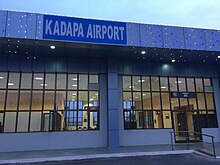
Kadapa Airport is located north west to Kadapa city.
Education

The primary and secondary school education is imparted by government, aided and private schools, under the School Education Department of the state.[34][35] As per[update] the school information report for the academic year 2015–16, there are a total of 4,488 schools. They include, 22 government, 3,094 mandal and zilla parishads, 1 residential, 1,181 private, 10 model, 29 Kasturba Gandhi Balika Vidyalaya (KGBV), 88 municipal and 63 other types of schools.[36] The total number of students enrolled in primary, upper primary and high schools of the district are 416,782.[37]
There are junior colleges for (10+2) education, among which 25 are under government, 13 are social welfare, 26 private aided, 83 are private unaided and also there are a few incentive, co-operative, government model colleges. For the purpose of imparting and the students sit for the certificate of Board of Intermediate Education.[38] The government colleges of Kadapa, Proddatur, Pulivendula, Rayachoti, Jammalamadugu, and Rajampet are the oldest government colleges of the district, established in 1969.[38]
The higher education colleges have various fields of study like medical, nursing, degree, post graduate, polytechnic, law, teaching, pharmacy, engineering, veterinary, etc. The Yogi Vemana University is a state university which has one autonomous college as per the Universities Grant Commission.[39] Sri Venkateswara College of Veterinary Sciences. The engineering colleges of the district are, KSRM College of Engineering, Annamacharya Institute of Technology and Sciences, etc.[39]

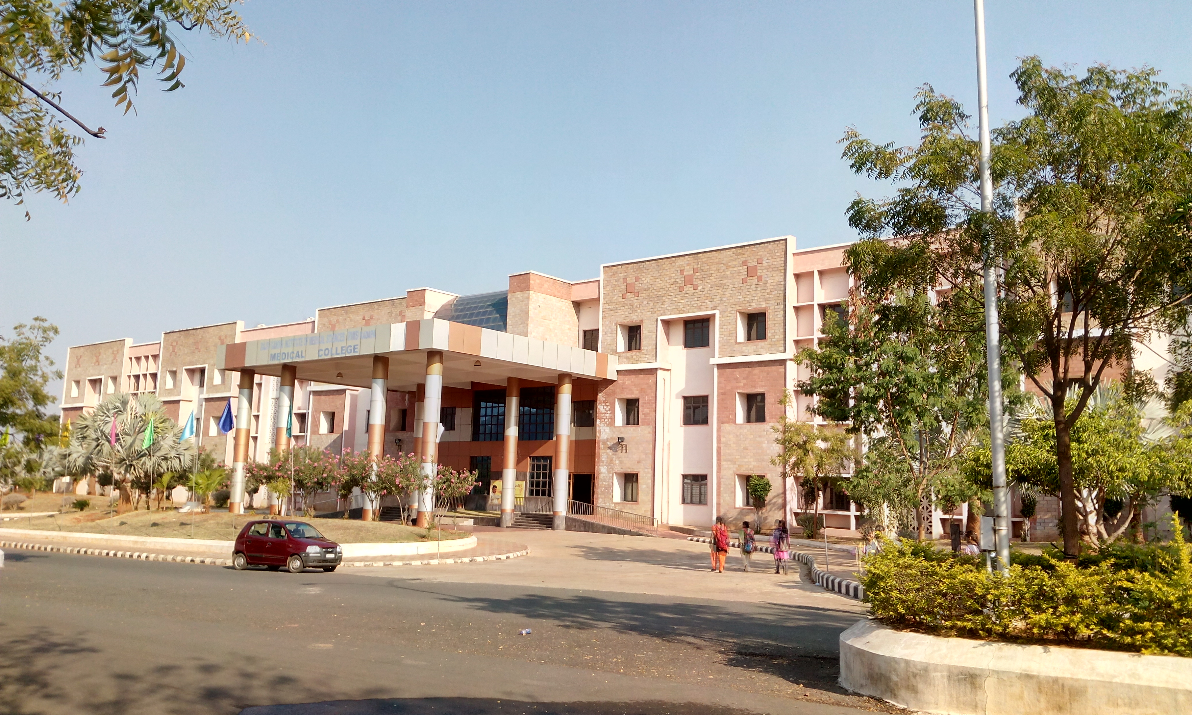
- Rajiv Gandhi Institute of Medical Sciences, Kadapa
- KSRM College of Engineering
- Yogi Vemana University
- Sri Venkateswara Veterinary College
- YSR Engineering College of YVU, Proddatur
- JNTUA College of Engineering, Pulivendula
Notable people
- Annamacharya, Hindu saint and musician
- Charles Philip Brown, Telugu author, district Collector
- P. Kannamba, actress and producer
- P. Jaya Kumar, filmmaker, screenwriter
- Atukuri Molla, poet
- Neelakanta (director), director
- B. Padmanabham, actor, comedian and producer
- Allasani Peddana, one of the poets in Astdiggajalu in Srikrishnadevarayalu
- B. N. Reddy, film director
- B. Nagi Reddy, film producer
- K. Jayachandra Reddy, Justice and former Supreme Court Judge
- V. N. Reddy, cinematographer
- Y. S. Rajasekhara Reddy, former chief minister of combined Andhra Pradesh
- Janamanchi Seshadri Sarma, poet
- Santha Kumari, musical artist and film actress
- Vavilikolanu Subbarao, poet
- Vemana, philosopher and poet
- Potuluri Veerabrahmam, saint and astrologer
- Y. Vijaya, character artist in Telugu and Tamil films
References
- "District Census Hand Book –" (PDF). Census of India. Registrar General and Census Commissioner of India. Retrieved 9 May 2019.
- "District Census Hand Book - YSR" (PDF). Census of India. Registrar General and Census Commissioner of India.
- Pincode List
- "New 'AP 39' code to register vehicles in Andhra Pradesh launched". The New Indian Express. Vijayawada. 31 January 2019. Retrieved 9 June 2019.
- "YSR District".
- "Ex-Andhra Pradesh CM YSR's native district Kadapa to be named after him". The Times of India. 18 June 2010. Archived from the original on 21 February 2020. Retrieved 1 May 2021.
- "Six districts in Andhra reel under drinking water crisis". The New Indian Express. Vijayawada. 13 May 2019. Retrieved 14 June 2019.
- Subramanyam, M.V. (25 July 2012). "Second largest rock art painting site explored". The Hindu. Chennai, India.
- Thapar, B.K., ed. (1980). Indian Archaeology 1976–77–A Review (PDF). New Delhi: Archaeological Survey of India, Government of India. Archived from the original (PDF) on 8 May 2012.
- Murty, M. L. K. (2003). Comprehensive History and Culture of Andhra Pradesh: Pre- and protohistoric ... google.co.in. ISBN 9788125024750.
- "Megalithic burial site found in Kadapa". The Hindu. Chennai, India. 24 June 2012.
- Lakshmi, V. Swarajya (1982). A Descriptive Grammar of Cuddapah Dialect. Telugu Akademi. p. 2.
- Mitra, Debala, ed. (1983). Indian Archaeology 1979–80—A Review (PDF). New Delhi: Archaeological Survey of India, Government of India. Archived from the original (PDF) on 8 May 2012.
- "Archaeological Survey of India". ap.nic.in. Archived from the original on 4 March 2016. Retrieved 14 May 2013.
- The Imperial Gazetteer of India, Volume 7. Oxford: Clarendon Press. 1908. pp. 158–76.
- "district news".
- Srivastava, Dayawanti; et al., eds. (2010). "States and Union Territories: Andhra Pradesh: Government". India 2010: A Reference Annual (54th ed.). New Delhi, India: Additional Director General, Publications Division, Ministry of Information and Broadcasting (India), Government of India. pp. 1111–1112. ISBN 978-81-230-1617-7.
- "Island Directory Tables: Islands by Land Area". United Nations Environment Program. 18 February 1998. Retrieved 11 October 2011.
Prince Patrick Island 15,848
- Correspondent, Special. "Krishna water released into Gandikota reservoir". The Hindu. Retrieved 19 March 2017.
- "Imperial Gazetteer2 of India, Volume 11, page 62 -- Imperial Gazetteer of India -- Digital South Asia Library".
- "Population by Religion - Andhra Pradesh". censusindia.gov.in. Office of the Registrar General & Census Commissioner, India. 2011.
- "Table C-16 Population by Mother Tongue: Andhra Pradesh". Census of India. Registrar General and Census Commissioner of India.
- "Economy of Kadapa District". Andhra Pradesh Economic Development Board. Retrieved 25 April 2017.
- "Tummalapalle uranium mill to start operation by March 2011". Article from the Times of India. WISE Uranium Project. 24 October 2010. Retrieved 19 July 2011.
- "India: 'Massive' uranium find in Andhra Pradesh". BBC News – South Asia. BBC. 19 July 2011. Retrieved 19 July 2011.
- Ministry of Panchayati Raj (8 September 2009). "A Note on the Backward Regions Grant Fund Programme" (PDF). National Institute of Rural Development. Archived from the original (PDF) on 5 April 2012. Retrieved 27 September 2011.
- "Revenue Divisions". National Informatics Centre. Archived from the original on 6 July 2015. Retrieved 22 May 2015.
- "Mandals in Kadapa district" (PDF). AP State Portal. Archived from the original (PDF) on 3 June 2016. Retrieved 20 July 2014.
- "District Revenue Divisions and Mandals". Y.S.R.-District Panchayat. National Informatics Centre. Retrieved 7 November 2014.
- correspondent, dc (7 April 2022). "AP cabinet approves two new revenue divisions". Deccan Chronicle. Retrieved 3 May 2022.
- "Andhra Pradesh (India): State, Major Agglomerations & Cities - Population Statistics, Maps, Charts, Weather and Web Information". www.citypopulation.de. Retrieved 6 September 2020.
- "Nagarpanchayats | Commissioner and Director of Municipal Administration". cdma.ap.gov.in. Retrieved 21 March 2021.
- "Existing State Highways" (PDF). Andhra Pradesh Road Development Corporation. Government of Andhra Pradesh. p. 1. Archived from the original (PDF) on 20 September 2018. Retrieved 11 May 2019.
- "School Education Department" (PDF). School Education Department, Government of Andhra Pradesh. Archived from the original (PDF) on 27 December 2015. Retrieved 7 November 2016.
- "The Department of School Education – Official AP State Government Portal". www.ap.gov.in. Archived from the original on 7 November 2016. Retrieved 7 November 2016.
- "School Information Report". Commissionerate of School Education. Government of Andhra Pradesh. Archived from the original on 8 November 2016. Retrieved 8 November 2016.
- "Student Information Report". Commissionerate of School Education. Child info 2015–16, District School Education – Andhra Pradesh. Archived from the original on 22 May 2015. Retrieved 8 November 2016.
- "List of colleges in Kadapa district" (PDF). Board of Intermediate Education. Retrieved 27 September 2016.
- "Autonomous colleges" (PDF). University Grants Commission. Archived from the original (PDF) on 18 October 2016. Retrieved 28 September 2016.
External links
Places adjacent to Kadapa district | |
|---|---|
Capital: Amaravati | |||
| Topics |
| ||
| Regions | |||
| Districts |
| ||
| Million-plus cities | |||
| Cities (population over 1 lakh) |
| ||
| Tourism |
| ||
| History |
| ||
| Related lists |
| ||
| |||
Authority control | |
|---|---|
| General |
|
| National libraries | |
На других языках
[de] YSR (Distrikt)
Der Distrikt YSR (Telugu వైఎస్ఆర్ జిల్లా .mw-parser-output .Latn{font-family:"Akzidenz Grotesk","Arial","Avant Garde Gothic","Calibri","Futura","Geneva","Gill Sans","Helvetica","Lucida Grande","Lucida Sans Unicode","Lucida Grande","Stone Sans","Tahoma","Trebuchet","Univers","Verdana"}Vai'esār Jillā), bis 2010 Distrikt Kadapa (ältere Schreibweise Cuddapah) ist ein Distrikt des indischen Bundesstaates Andhra Pradesh. Verwaltungssitz ist die Stadt Kadapa. Am 8. Juli 2010 wurde der Distrikt zu Ehren des im gleichen Jahr tödlich verunfallten Regierungschefs Y. S. Rajasekhara Reddy (genannt YSR) in Distrikt YSR umbenannt.[1]- [en] Kadapa district
[ru] ЕСР (округ)
ЕСР ([йе-эс-эр], телугу వైఎస్ఆర్ జిల్లా IAST: Vaj-es-ār, англ. Y.S.R. [waı.es.aːr]; ранее назывался Када́па, телугу కడప జిల్లా IAST: kaḍapa; урду کڈپہ ضلع; англ. Kadapa, и Кудда́па, англ. Cuddapah) — округ в южной части индийского штата Андхра-Прадеш. Административный центр — город Кадапа.Другой контент может иметь иную лицензию. Перед использованием материалов сайта WikiSort.org внимательно изучите правила лицензирования конкретных элементов наполнения сайта.
WikiSort.org - проект по пересортировке и дополнению контента Википедии