world.wikisort.org - India
Gannavaram mandal is one of the 25 mandals in Krishna district of the Indian state of Andhra Pradesh. It is under the administration of Gudivada revenue division and the mandal headquarters are located at Gannavaram.[2][3] The mandal is bounded by Agiripalle, Bapulapadu, Unguturu, Vijayawada (rural) and Kankipadu mandals.[4] The mandal is also a part of the Andhra Pradesh Capital Region under the jurisdiction of APCRDA.[5]
Gannavaram mandal | |
|---|---|
Mandal | |
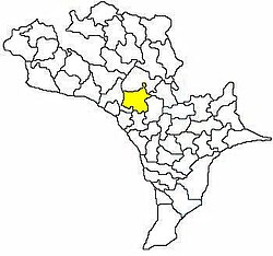
 Mandal map of Krishna district showing Gannavaram mandal (in yellow) | |
 Gannavaram mandal Location in Andhra Pradesh, India | |
| Coordinates: 16.5333°N 80.8000°E | |
| Country | India |
| State | Andhra Pradesh |
| District | Krishna |
| Headquarters | Gannavaram |
| Population (2011)[1] | |
| • Total | 238,962 |
| Languages | |
| • Official | Telugu |
| Time zone | UTC+5:30 (IST) |
| Vehicle registration | AP |
Demographics
As of 2011[update] census, the mandal had a population of 87,027. The total population constitute, 43,172 males and 43,855 females —a sex ratio of 1016 females per 1000 males. 8,098 children are in the age group of 0–6 years, of which 4,147 are boys and 3,951 are girls. The average literacy rate stands at 73.96% with 58,379 literates.[1]
Towns and villages
As of 2011[update] census, the mandal has 24 villages and no towns.[2][6] Gannavaram is the most populated and Venkatanarasimhapuram is the least populated villages in the mandal.[7]
The settlements in the mandal are listed below:
- Ajjampudi
- Allapuram
- Bahubalendrunigudem
- Balliparru
- Buddavaram
- Buthumillipadu
- Chikkavaram
- China Avutapalle
- Gannavaram
- Gollanapalle
- Gopavarapugudem
- Jakkulanekkalam
- Kesarapalle
- Kondapavuluru
- Kothagudem
- Metlapalle
- Purushottapatnam
- Ramachandrapuram
- Sagguruamani
- Savarigudem
- Surampalle
- Tempalle
- Vedurupavuluru
- Veerapanenigudem
- Venkatanarasimhapuram
See also
- List of villages in Krishna district
References
- "Census 2011". The Registrar General & Census Commissioner, India. Retrieved 12 September 2014.
- "Krishna District Mandals" (PDF). Census of India. pp. 495, 526–527. Retrieved 19 January 2015.
- "Administrative Setup". Krishna District Official Website. National Informatics Centre. Archived from the original on 20 October 2014. Retrieved 9 February 2015.
- "Mandals in Krishna district". aponline.gov.in. Archived from the original on 13 December 2014. Retrieved 14 September 2014.
- "Andhra Pradesh Capital Region Development Authority Act, 2014" (PDF). News19. Municipal Administration and Urban Development Department. 30 December 2014. Archived from the original (PDF) on 18 February 2015. Retrieved 9 February 2015.
- "Gannavaram mandal villages" (PDF). Chief Commissioner of Land Administration, Govt. of Andhra Pradesh. National Informatics Centre. p. 4. Archived from the original (PDF) on 10 October 2014. Retrieved 10 February 2015.
- "Sub-District Details of Krishna District". The Registrar General & Census Commissioner, India. Retrieved 14 September 2014.
Другой контент может иметь иную лицензию. Перед использованием материалов сайта WikiSort.org внимательно изучите правила лицензирования конкретных элементов наполнения сайта.
WikiSort.org - проект по пересортировке и дополнению контента Википедии