world.wikisort.org - India
Aurangabad district (Marathi pronunciation: [əu̯ɾəŋɡaːbaːd̪], Urdu pronunciation:[ɔːɾəŋɡaːbaːd̪]) is one of the 36 districts of the state of Maharashtra in western India. It borders the districts of Nashik to the west, Jalgaon to the north, Jalna to the east, and Ahmednagar to the south. The city of Aurangabad houses the district's administrative headquarters. The district has an area of 10,100 km2, of which 37.55% is urban and the rest is rural. Aurangabad District is a major tourism region in Marathwada.
Aurangabad district | |
|---|---|
District of Maharashtra | |
      Clockwise from top-left: Kailasha temple at Ellora Caves, Cave 19 at the Ajanta Caves, Bibi Ka Maqbara, Daulatabad Fort, Tomb of Aurangzeb Khuldabad | |
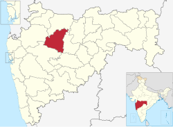 Location in Maharashtra | |
 Aurangabad district | |
| Country | |
| State | Maharashtra |
| Division | Aurangabad |
| Headquarters | Aurangabad |
| Tehsils | |
| Government | |
| • Body | Aurangabad Zilla Parishad |
| • Guardian Minister | Sandipanrao Bhumre (Cabinet Minister Mha) |
| • President Zilla Parishad |
|
| • District Collector |
|
| • CEO Zilla Parishad |
|
| • MPs |
|
| Area | |
| • Total | 10,100 km2 (3,900 sq mi) |
| Population (2011) | |
| • Total | 3,701,282 |
| • Density | 370/km2 (950/sq mi) |
| • Urban | 37.53% |
| Demographics | |
| • Literacy | 61.15% |
| • Sex ratio | 924 |
| Time zone | UTC+05:30 (IST) |
| Major highways | NH-211 |
| Official Language | Marathi |
| Per capita income(Aurangabad district) | INR 1,63,325(2019-20)[1] |
| Nominal gross domestic product(Aurangabad district) | INR 74,738crores (2019-20)[2] |
| Website | aurangabad |
Officer
Members of Parliament
- Imtiyaz Jaleel (MIM)
(Aurangabad) - Raosaheb Danve (BJP)
(Jalna)
Guardian Minister
| Guardian Minister Aurangabad | |
|---|---|
| पालकमंत्री औरंगाबाद | |
 Emblem of India | |
Incumbent Sandipanrao Bhumre since 27 September 2022 | |
| Style | The Honourable |
| Appointer | Chief Minister of Maharashtra |
| Term length | 5 years / No time limit |
| Website | aurangabad |
list of Guardian Minister
| Name | Term of office |
|---|---|
| Subhash Desai | 9 January 2020 - 29 June 2022 |
| Sandipanrao Bhumre | 27 September 2022 - Incumbent |
District Magistrate/Collector
| District Magistrate / Collector Aurangabad | |
|---|---|
| जिल्हाधिकारी तथा जिल्हदंडाधिकरी औरंगाबाद | |
Emblem of India | |
Incumbent Mr. Sunil Chavan (IAS) since 2019 | |
| Residence | At Aurangabad district |
| Appointer | Government of Maharashtra |
| Term length | No time limit |
| Website | aurangabad |
list of District Magistrate / Collector
| Name | Term of office |
|---|---|
| Ms. Nidhi Chaudhary (IAS) | Till 21 August 2021 |
| Dr. Mahendra Kalyankar (IAS) | 23 August 2021 - Incumbent |
Geography
Aurangabad District is located mainly in the Godavari River Basin and partly in the Tapti River Basin. The district is located between 19 and 20 degrees north longitude and between 74 and 76 degrees east latitude, covering an area of 10,100 km2.[3]
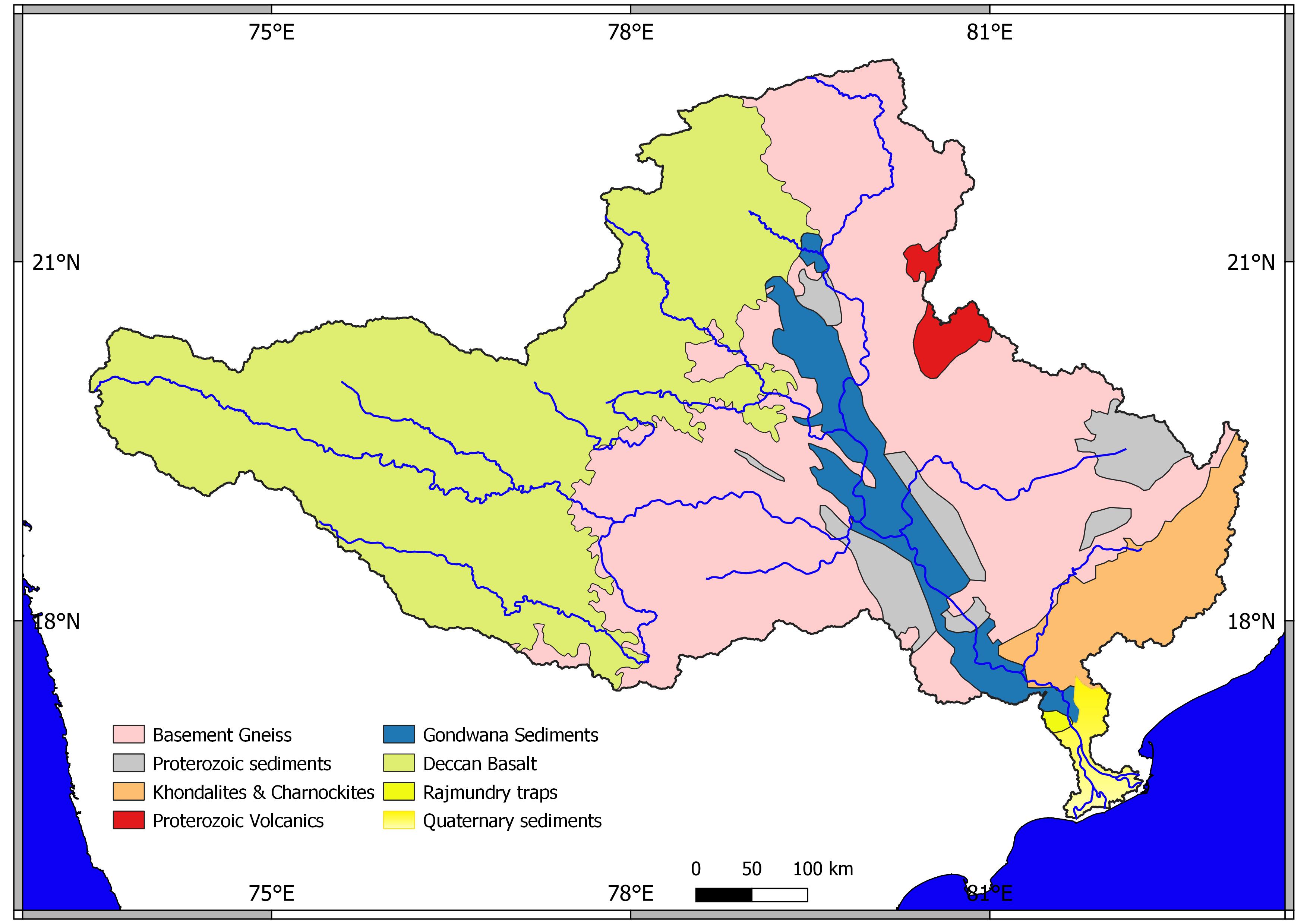
Geology
Geological formations
Aurangabad District lies on the Deccan plateau and is covered by the Deccan Traps, which formed during the Late Cretaceous and Lower Eocene ages. Thin alluvial deposits lie above the Deccan Traps along the major rivers. The basaltic lava flows belonging to the Deccan Traps are the only major geological formation in the district. The lava flows are horizontal, with each flow featuring two distinct layers. The upper layer consists of vesicular and amygdule zeolitic basalt, while the lower layer consists of massive basalt.[4]
Elevation and mountains
The average height of southern portion of the district is between 600 and 670 metres. The district features four distinct mountains:[3]
- Antur – 827 m
- Abbasgad – 671 m
- Satonda – 552 m
- Ajintha – 578 m
Rivers
The major rivers in Aurangabad District are the Godavari, Purna, Shivana, and Kham rivers.[3]
The Narangi river rises on the southern slopes of the water divide south of the Maniyad river near the village of Naral. It flows past Vaijapur, where it is joined by the Deo Nala river from Nasik District. The Narangi follows a long south-southwesterly course before its point of entry into the Godavari. It is joined by the Chor nala from the west and the Kurla nala from the east, continuing the trend of the Kurla river after the Kurla's confluence.[citation needed]
Climate
The rainy season lasts from June through September and the average rainfall is 734 mm. The temperature ranges from 14 to 40 degrees Celsius on average. The winter season is from October to February and the summer season is from March to May.
| Climate data for Aurangabad | |||||||||||||
|---|---|---|---|---|---|---|---|---|---|---|---|---|---|
| Month | Jan | Feb | Mar | Apr | May | Jun | Jul | Aug | Sep | Oct | Nov | Dec | Year |
| Average high °C (°F) | 29.7 (85.5) |
32.5 (90.5) |
36.1 (97.0) |
39.0 (102.2) |
39.9 (103.8) |
34.9 (94.8) |
30.3 (86.5) |
29.1 (84.4) |
30.4 (86.7) |
32.6 (90.7) |
30.9 (87.6) |
29.3 (84.7) |
32.9 (91.2) |
| Average low °C (°F) | 14.2 (57.6) |
16.3 (61.3) |
20.2 (68.4) |
23.7 (74.7) |
24.6 (76.3) |
23.0 (73.4) |
21.8 (71.2) |
21.1 (70.0) |
20.9 (69.6) |
19.7 (67.5) |
16.4 (61.5) |
14.0 (57.2) |
19.7 (67.5) |
| Average precipitation mm (inches) | 2.2 (0.09) |
2.9 (0.11) |
5.1 (0.20) |
6.3 (0.25) |
25.5 (1.00) |
131.4 (5.17) |
167.0 (6.57) |
165.0 (6.50) |
135.3 (5.33) |
52.6 (2.07) |
29.3 (1.15) |
8.4 (0.33) |
731.0 (28.78) |
| Source: IMD | |||||||||||||
Administrative divisions
The district comprises nine tehsils: Kannad, Soyagaon, Sillod, Phulambri, Aurangabad, Khuldabad, Vaijapur, Gangapur, and Paithan.the new proposal for tehsil is lasur and pishor . Rhe big towns were divide from gangapur tehsil and kannad tehsil
Nine Maharashtra Vidhan Sabha constituencies are located in this district: Sillod, Kannad, Phulambri, Aurangabad Central, Aurangabad West, Aurangabad East, Paithan, Gangapur, and Vaijapur.
The Vidhan Sabha constituencies are grouped into two Lok Sabha constituencies: Aurangabad and Jalna.[5]
Demographics
| Year | Pop. | ±% p.a. |
|---|---|---|
| 1901 | 444,492 | — |
| 1911 | 533,331 | +1.84% |
| 1921 | 436,921 | −1.97% |
| 1931 | 579,857 | +2.87% |
| 1941 | 656,289 | +1.25% |
| 1951 | 714,894 | +0.86% |
| 1961 | 943,092 | +2.81% |
| 1971 | 1,241,195 | +2.78% |
| 1981 | 1,589,754 | +2.51% |
| 1991 | 2,218,615 | +3.39% |
| 2001 | 2,902,602 | +2.72% |
| 2011 | 3,701,282 | +2.46% |
| source:[6] | ||
According to the 2011 census, Aurangabad District has a population of 3,701,282 inhabitants and a population density of 365 inhabitants per square kilometre (950/sq mi). It is the 72nd most populous district in India out of 640 total districts, and the population growth rate between 2001 and 2011 was 27.33%.[7] The population of the district is 37.53% urban as of 2001. Scheduled Castes and Scheduled Tribes made up 14.57% and 3.87% of the population respectively.[8]
The district has a sex ratio of 917 females for every 1000 males and a literacy rate of 80.4%.[7]
Religions
According to the 2011 census, Hinduism is the most popular religion in the district and is practiced by 69% of the population. Other popular religions include Islam (21%), Buddhism (mainly Navayana Buddhism, 8.35%) and Jainism (0.84%).[10]
Languages
As of the 2011 Census of India, 69.66% of the population in the district speaks Marathi, 14.51% Urdu, 9.49% Hindi and 2.57% Lambadi as their first language.[11]
Transportation
Road
- Mumbai – Aurangabad
- Hyderabad – Aurangabad
- Nagpur – Aurangabad
- Dhule – Aurangabad
- Pune – Aurangabad (approximately 4.5 hours journey time)
- Solapur – Aurangabad
Rail
The Manmad-Kachiguda Railway Station Broad gauge railway line emanates from the Mumbai-Bhusawal-Howrah trunk route at Manmad and is an important traffic artery in Aurangabad District. Routes include:
- Mumbai – Aurangabad
- Hyderabad – Nanded – Aurangabad
- Secunderabad – Bangalore – Parbhani – Aurangabad
- Delhi – Aurangabad – Delhi
- Nagpur – Aurangabad – Nagpur
- Mumbai-Aurangabad – Mumbai – Janshatabdi Express (daily service)
- Nandigram Express – via – Aurangabad to Mumbai (daily service)
- Devgiri Express – via – Aurangabad to Mumbai (daily service)
- Tapovan Express (AWB to NED)(Nanded) or (AWB to CSTM )(Mumbai)(daily service)
- Marathwada Express- (AWB to DAB)()Darmabad) or AWB To MMR(Manmad Jn) (Daily Service)
- Sachkhand Express- (AWB to NED)(Nanded) or (AWB to ASR) Amritsar JN(Daily Service)
Aurangabad Airport has flights to Delhi, Mumbai, Hyderabad-Tirupati, Ahmedabad, Bengaluru, Udaipur, and Jaipur.[citation needed]
Tourism
There are many points of interest in Aurangabad District, including temples, villages, gardens, and sanctuaries.
Indian rock-cut architecture
- Ajanta Caves, Aurangabad Caves and Ellora Caves
 The Ajanta Caves are 30 rock-cut Buddhist cave monuments built beneath the Vakatakas.
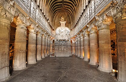 Buddhist "Chaitya Griha" (prayer hall) with a seated Buddha in Cave 26 of the Ajanta Caves.
 Chaitya with stupa, Cave 4, Aurangabad Caves.
 Various sculptors next to an entrance at Aurangabad Caves.
 Central pillar near Kailasa temple at Ellora Caves.
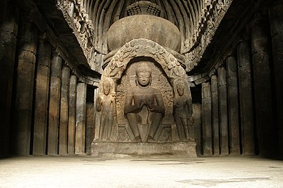 Statue of the Buddha seated. Part of the Carpenter's cave (Buddhist Cave 10).
 Kailasa temple, Ellora, Aurangabad
 Buddhist monks praying in front of the Dagoba of Chaitya in Cave 26 of the Ajanta Caves.


Caves
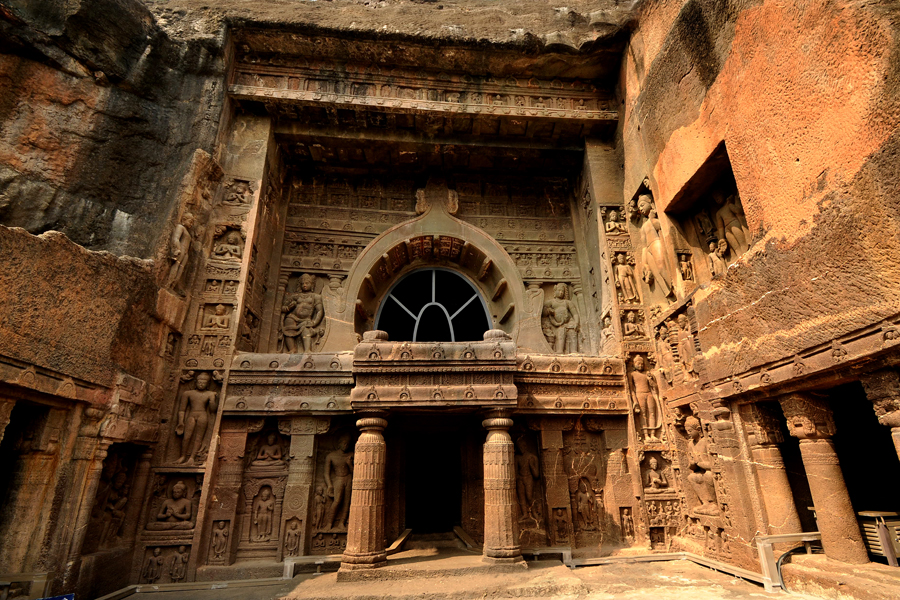
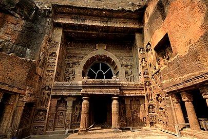
- The Ajanta Caves are situated 107 km (66 mi) from Aurangabad city. They comprise 30 rock-cut caves around a gorge and were built by the Satavahana, Vakataka and Chalukya dynasties between the 2nd and 5th centuries CE.[12] They contain various works of ancient Indian art, including paintings which are among the rarest and finest surviving examples of their era.[13] The Ajanta Caves are a UNESCO World Heritage Site.
- The Ellora Caves are 29 km (18 mi) from Aurangabad city. They consist of 34 caves built between the 5th and 10th centuries CE under the patronage of the Rashtrakuta Dynasty. They represent the epitome of Indian rock cut architecture.[14] Like the Ajanta Caves, the Ellora Caves are also a UNESCO World Heritage Site.
- The Aurangabad Caves are 5 km (3 mi) from Aurangabad city. Nestled amidst the hills are 12 Buddhist caves dating back to 3 A.D. Of particular interest are the Tantric influences evident in the iconography and architectural design of the caves.
Holy sites
 View of Grishneshwar temple
 Idol of Lord Shri Parshvanath at Kachner temple
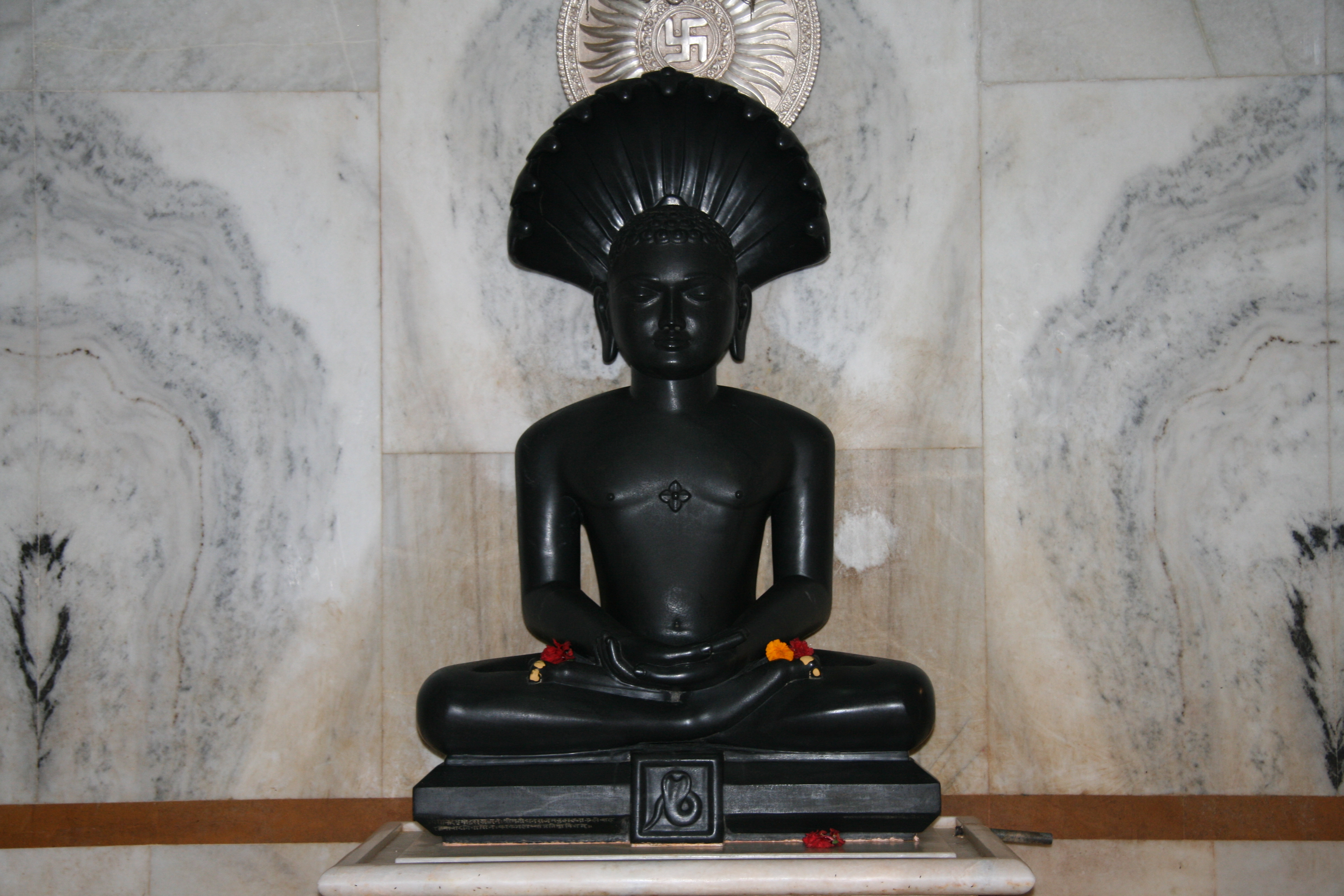

- Grishneshwar Temple is one of the 12 Jyotirlinga shrines in India. It was built by Ahilyabai Holkar in the 18th century CE. The structure is a unique example of Bhoomija architecture with a Maratha style influence.[15]
- Kachner Jain Temple is a 250 year old temple dedicated to Parshvanatha. It contains an idol called Chintamani Parshvanath.
- Shuli Bhanjan is a hill near Aurangabad. It is believed that Saint Eknath Maharaj carried his Tapasya here.
Hindu temples and shrines
Due to the popularity of Hinduism in the region, there are dozens of Hindu temples and shrines.
- Grishneshwar temple
- Kailash temple, Ellora caves, Verul
- Khadakeshwar temple.
- Vitthal Mandir, Pandharpur, A'bad.
- Renukamata mandir, Karnapura. Karnapura Temple.
- Sansthan Ganapati mandir.
- Siddhivinayak mandir.
- Pavan Ganesh mandir.
- Sai Tekadi (Hill).
- Hanuman Tekadi (Hill).
- Khandoba Mandir, Satara.
- Shri Bhadra Maruti Mandir.
- Sant Dnyaneshwar Mandir, Paithan.
- Eknath Maharaj Mandir, Paithan.
- Savata Maharaj Mandir, Vaijapur.
- Mahalakshmi Mandir, Vaijapur.
- Virbhadra Temple, Vaijapur.
- Sant Danshower Maharaj Sansthan.
- Mhasoba Maharaj Mandir, Sillod.
- Sindhi mandir, Sillod.
- Shree Chakradhar Swami Mandir, Gangapur.
- Panchavati Mahadev mandir, Gangapur.
- Ekmukhi Datt Mandir, Gangapur.
- Bhairavnath Mandir, Soegaon.
- Munjoba mandir, Soegaon.
- Mahamuni Agasti Maharaj Warkari Shikshan Sansthan, Soegaon.
- Ram mandir, Kannad.
- Bajarangbali mandir, Kannad.
- Jagrut Siddhivinayak temple, Kannad.
Gates and forts
 Front view of Daulatabad Fort
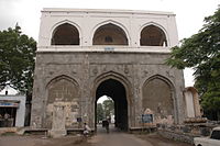 Bhadkal Gate


The city of Aurangabad is known for its 52 gates and has been called the "City of Gates". These gates were built during Mughal era.[16]
Daulatabad Fort (aka Devagiri Fort), located some 15 km (9 mi) north-west of Aurangabad, was built in the 12th century CE by the Yadava Dynasty. It was one of the most powerful forts during the medieval era. The fort was built on a 200-metre-high (660 ft) conical hill and defended by moats, trenches, and three encircling walls with bastions. It also had two fixed massive canons which could be pivoted. The fort was never conquered by any military force.[17]
Mughal architecture
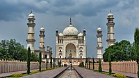 Bibi Ka Maqbara
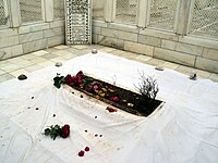 Tomb of Aurangzeb

- The Bibi Ka Maqbara is the burial mausoleum of Emperor Aurangzeb's wife, Dilras Banu Begum (posthumously known as Rabia-ud-Daurani). The site is 3 km (2 mi) from Aurangabad city. It is an imitation of the Taj Mahal at Agra and is popularly known as the "Taj of the Deccan".[18]
- The Tomb of Aurangzeb is located in the village of Khuldabad, 24 km (15 mi) to the north-west of Aurangabad city, in the south-eastern corner of the complex of the dargah of Sheikh Zainuddin.[19] Aurangzeb is considered to have been last great Mughal emperor.[20]
Other notable sites
 Panchakki was designed to generate energy from water flowing down a mountain. It displays the scientific thought process that guided medieval Indian architecture.
 Siddharth Garden near a bus stand in Aurangabad
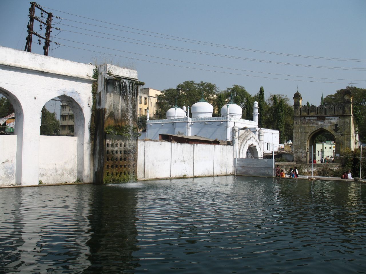


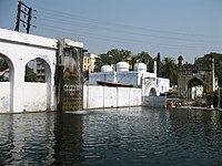
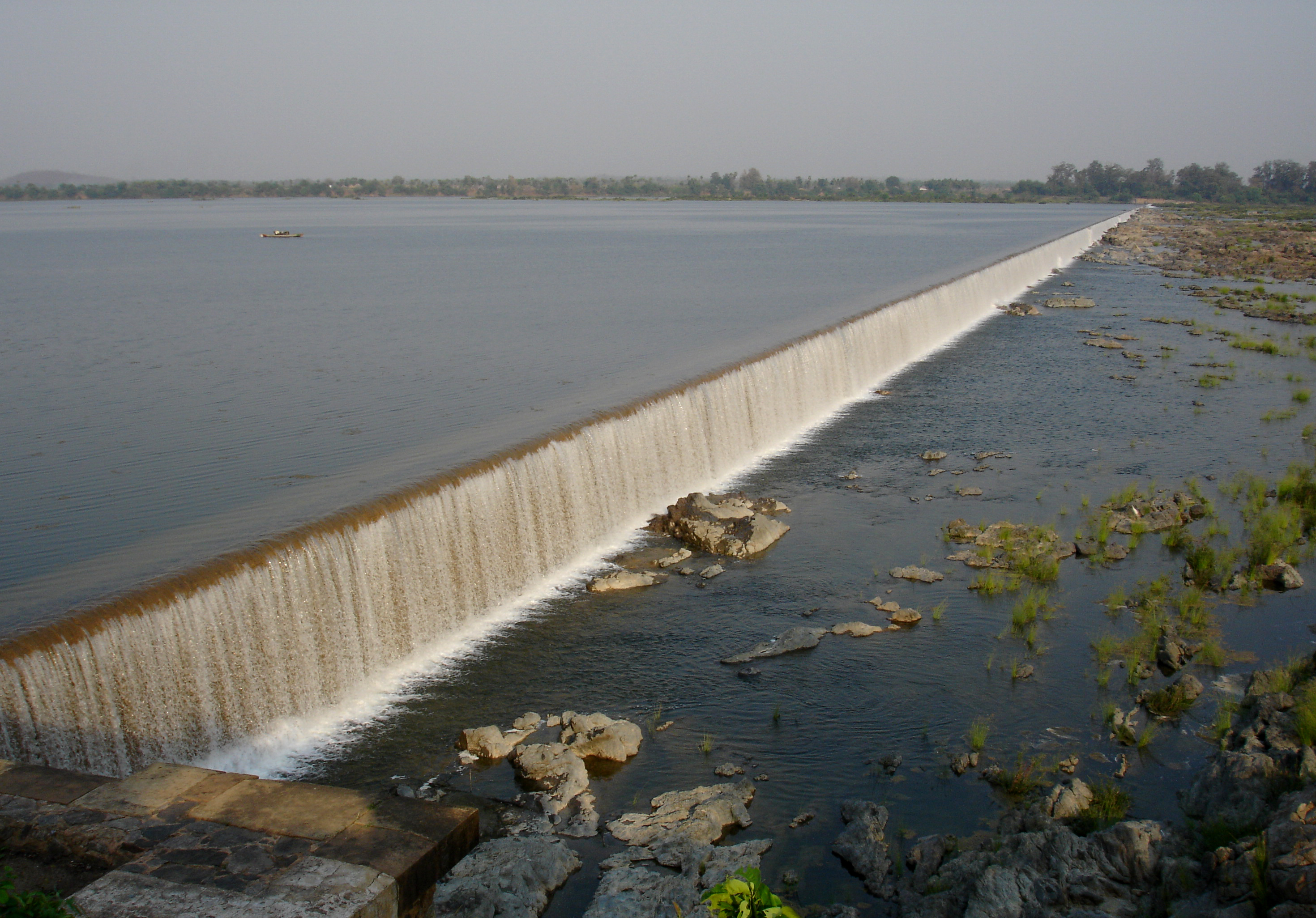
- Panchakki, which literally means "water mill", is a 17th-century water mill situated within the old city of Aurangabad. It is known for its underground channel, which carries water from hills over 8 km away. The channel culminates in an artificial waterfall that powers the mill.
- Salim Ali Lake & Bird Sanctuary is located in the northern part of the city near Delhi Darwaza, opposite Himayat Bagh. During the Mughal period, it was known as Khiziri Talab. It was renamed after the great ornithologist and naturalist Salim Ali. It features a bird sanctuary and a garden maintained by the Aurangabad Municipal Corporation.
- Siddharth Garden and Zoo is situated near the central bus station in Aurangabad city. It is the only zoo in the Marathwada region. It is home to several species of animals, birds, flowers, and trees. The name "Siddhartha" is a reference to Gautama Buddha.[21][22][23]
See also
- Tourism in Marathwada
- Aurangabad Industrial City
References
- Records, Official. "Per capita income of district of Maharashtra 2019-20". economy Department, Government of Maharashtra, India. Maharashtra Vidhanmanda.
- Records, Official. "nominal gross district Domestic Product of Maharashtra 2019-20". economy Department, Government of Maharashtra, India. Maharashtra Vidhanmanda.
- "About District". District Aurangabad. Government of Maharashtra. 28 April 2020. Retrieved 17 May 2020.
- K.R. Aher and S.M. Deshpande 'Assessment of Water Quality of the Maniyad Reservoir of Parala Village, district Aurangabad: Suitability for Multipurpose Usage Vol.1(3), pp 91–95, 2011, E-ISSN 2249-8109.
- "District wise List of Assembly and Parliamentary Constituencies". Chief Electoral Officer, Maharashtra website. Archived from the original on 25 February 2009.
- Decadal Variation In Population Since 1901
- "District Census 2011 - Aurangabad" (PDF). Office of the Registrar General, India. 2011.
- "Census GIS India". Archived from the original on 24 May 2012. Retrieved 12 March 2008.
- "C-16 Population By Religion - Maharashtra". census.gov.in.
- "C-1 Population By Religious Community". Census. Retrieved 10 June 2019.
- "Table C-16 Population by Mother Tongue: Maharashtra". censusindia.gov.in. Registrar General and Census Commissioner of India.
- "Indian Heritage – Ajanta Cave paintings – Period of Excavation, Patronage, Re-discovery". Archived from the original on 28 February 2015. Retrieved 29 October 2015.
- "Archaeological Survey of India". Archived from the original on 9 October 2015. Retrieved 29 October 2015.
- "Ellora Caves, Maharashtra – Archaeological Survey of India". Archived from the original on 7 October 2015. Retrieved 29 October 2015.
- "Aurangabad". Archived from the original on 25 December 2015. Retrieved 9 August 2018.
- Banerjee, Rajiv (12 April 2009). "History revisited at Aurangabad the 'city of gates'". The Economic Times. Archived from the original on 24 March 2014. Retrieved 27 February 2014.
- "Daulatabad Fort – Ticketed Monument – Archaeological Survey of India". Archived from the original on 29 April 2015. Retrieved 29 October 2015.
- P., Bhaskar. "The Taj of Deccan". Deccan Herald. Archived from the original on 3 March 2014. Retrieved 27 February 2014.
- "Tomb of Aurangzeb" (PDF). Archaeological Survey of India, Aurangabad. Archived (PDF) from the original on 23 September 2015. Retrieved 29 October 2015.
- "India's 10 greatest warrior Emperors and Kings | All About History". Archived from the original on 20 July 2018. Retrieved 19 July 2018.
- "वृक्ष, वन्यप्राण्यांचे सवंर्धन करा". Archived from the original on 12 January 2019. Retrieved 12 January 2019.
- "औरंगाबादच्या सिद्धार्थ उद्यानातील प्राणी संग्रहालय बंद होणार !". December 2018.
- "Siddharth Garden Zoo". Archived from the original on 6 January 2016. Retrieved 29 October 2015.
External links
- "District Aurangabad – Government of Maharashtra". Aurangabad.gov.in. Retrieved 12 March 2019.
Places adjacent to Aurangabad district, Maharashtra | ||||||||||||||||
|---|---|---|---|---|---|---|---|---|---|---|---|---|---|---|---|---|
| ||||||||||||||||
| Districts of Marathwada | |
|---|---|
| Cities with municipal corporations | |
| Topics |
|
Portal:India | |
| History |
|  |
|---|---|---|
| Geography | ||
| Monuments |
| |
| Culture |
| |
| Education |
| |
| Transport |
| |
| Cities and towns | ||
| Neighbourhoods |
| |
| Industrial projects |
| |
| Lok Sabha constituencies |
| |
| Assembly constituencies |
| |
| Judiciary |
| |
| Sports | ||
| Other topics |
| |
| Topics |
| ||||||||||||
|---|---|---|---|---|---|---|---|---|---|---|---|---|---|
| Regions |
| ||||||||||||
| Divisions and Districts |
| ||||||||||||
| Million-plus cities in Maharashtra |
| ||||||||||||
| Other cities with municipal corporations | |||||||||||||
Portal:India | |||||||||||||
Godavari basin | |||||||||||||||
|---|---|---|---|---|---|---|---|---|---|---|---|---|---|---|---|
| Rivers |
|     | |||||||||||||
| Dams, barrages |
| ||||||||||||||
| Geographical features / regions | |||||||||||||||
| Riparian districts |
| ||||||||||||||
| Cities | |||||||||||||||
| Languages / people | |||||||||||||||
| Coalfields |
| ||||||||||||||
| Oil / gas fields |
| ||||||||||||||
| Industries |
| ||||||||||||||
| Transport |
| ||||||||||||||
| Pollution concerns, River basin's sustainable productivity & ecology |
| ||||||||||||||
| Related topics |
| ||||||||||||||
| Other basins | |||||||||||||||
| Authority control |
|
|---|
На других языках
[de] Aurangabad (Distrikt, Maharashtra)
Der Distrikt Aurangabad (Marathi: .mw-parser-output .Deva{font-size:120%}@media all and (min-width:800px){.mw-parser-output .Deva{font-size:calc(120% - ((100vw - 800px)/80))}}@media all and (min-width:1000px){.mw-parser-output .Deva{font-size:100%}}औरंगाबाद जिल्हा) ist einer von 35 Distrikten des Staates Maharashtra in Indien.- [en] Aurangabad district, Maharashtra
[ru] Аурангабад (округ, Махараштра)
Аурангаба́д (маратх. औरंगाबाद जिल्हा; англ. Aurangabad) — округ в индийском штате Махараштра. Образован 1 мая 1960 года. Административный центр — город Аурангабад. Площадь округа — 10 107 км². По данным всеиндийской переписи 2001 года население округа составляло 2 897 013 человек. Уровень грамотности взрослого населения составлял 72,9 %, что выше среднеиндийского уровня (59,5 %). Доля городского населения составляла 37,5 %.Другой контент может иметь иную лицензию. Перед использованием материалов сайта WikiSort.org внимательно изучите правила лицензирования конкретных элементов наполнения сайта.
WikiSort.org - проект по пересортировке и дополнению контента Википедии