world.wikisort.org - India
Kodagu (also known by its former name Coorg) is an administrative district in the Karnataka state of India. Before 1956, it was an administratively separate Coorg State,[3] at which point it was merged into an enlarged Mysore State.[4]
This article possibly contains original research. (March 2019) |
Kodagu district
Coorg district, Koḍava nāḍ (Kodava language) | |
|---|---|
District of Karnataka | |
     Clockwise from top-left: Perumbadi Lake, Nalakanadu Palace, Talakaveri, Brahmagiri Hills, Abbey Falls | |
| Nicknames: Scotland of India, The Land of Warriors, Coffee Cup of India | |
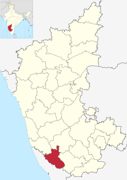 Location in Karnataka | |
 Kodagu district | |
| Coordinates: 12.4208°N 75.7397°E | |
| Country | |
| State | Karnataka |
| Region | Malnad |
| Headquarters | Madikeri |
| Talukas | Madikeri, Somwarpet, Virajpet, Ponnampet, Kushalanagar |
| Government | |
| • Deputy Commissioner | B. C. Satheesh (IAS) |
| • MP | Pratap Simha |
| • MLA |
|
| Area | |
| • Total | 4,102 km2 (1,584 sq mi) |
| • Rank | 26th (31 districts) |
| Elevation | 900 m (3,000 ft) |
| Population (2011)[2] | |
| • Total | 554,519 |
| • Rank | 31st (31 districts) |
| • Density | 140/km2 (350/sq mi) |
| Demonym | Kodava |
| Languages | |
| • Official | Kannada |
| • Regional | Kannada, Kodava, Arebhashe[2] |
| Time zone | UTC+5:30 (IST) |
| PIN | 571201 (Madikeri) |
| Telephone code |
|
| Vehicle registration | KA-12 |
| Literacy | 82.52% |
| Lok Sabha constituency | Mysore Lok Sabha constituency |
| Karnataka Legislative Assembly constituency | Madikeri, Virajpet |
| Climate | Tropical Wet (Köppen) |
| Precipitation | 2,725.5 millimetres (107.30 in) |
| Avg. summer temperature | 28.6 °C (83.5 °F) |
| Avg. winter temperature | 14.2 °C (57.6 °F) |
| Website | kodagu |
| Part of a series on the |
| Culture of Karnataka |
|---|
 |
It occupies an area of 4,102 square kilometres (1,584 sq mi) in the Western Ghats of southwestern Karnataka. In 2001 its population was 548,561, 13.74% of which resided in the district's urban centre, making it the least populous of the 31 districts in Karnataka.
The nearest railway stations are Mysore Junction, located around 95 kilometres (59 mi) away, Thalassery, and Kannur, the latter two located in Kerala at a distance of about 79 kilometres (49 mi). The nearest airports are Kannur International Airport in Kerala (59 kilometres (37 mi) from Kodagu) and Mangalore International Airport (118 kilometres (73 mi) from Kodagu).
Geography
Kodagu is located on the eastern slopes of the Western Ghats. It has a geographical area of 4,102 km2 (1,584 sq mi).[5] The district is bordered by Dakshina Kannada district to the northwest, Hassan district to the north, Mysore district to the east, Kasaragod district of Kerala in west and Kannur district of Kerala to the southwest, and Wayanad district of Kerala to the south. It is a hilly district, the lowest elevation being 50 metres (160 ft) above sea-level near makutta. The highest peak, Tadiandamol, rises to 1,750 metres (5,740 ft), with Pushpagiri, the second highest, at 1,715 metres (5,627 ft). The main river in Kodagu is the Kaveri (Cauvery), which originates at Talakaveri, located on the eastern side of the Western Ghats, and with its tributaries, drains the greater part of Kodagu.
Rivers (Mouth)
- Kaveri (Bay of Bengal)
- Payaswini (Arabian Sea)
- Tejaswini (Arabian Sea)
- Kuppam River (Arabian Sea)
- Valapattanam River (Arabian Sea)
- Harangi (Kaveri)
- Lakshmana Tirtha (Kaveri)
- Barapole (Valapattanam River)
- Kumaradhara (Netravathi River)
Peaks
- Tadiyandamol
- Kumara Parvatha
- Brahmagiri
- Kote Betta
- Kabbe Hill
- Mandalpatti
- Nishane Motte
- Malethirike
Administrative divisions
Taluks
The district is divided into five administrative taluks:
Representation
Two members of the legislative assembly are elected from Kodagu to the Karnataka Legislative Assembly, one each from the Madikeri and Virajpet. M P Appachu Ranjan represents the Madikeri constituency while K. G. Bopaiah represents the Virajpet constituency; they are from the Bharatiya Janata Party. Kodagu, formerly part of the Kodagu-Dakshina Kannada (Mangalore) constituency, is now part of the Mysore Lok Sabha parliamentary constituency. The current MP for this constituency is Shri Pratap Simha, from the Bharatiya Janata Party.
The Codava National Council and Kodava Rashtriya Samiti are campaigning for autonomy to Kodagu district.[6][7]
History

The Kodavas were the earliest inhabitants and agriculturists in Kodagu, having lived there for centuries. Kodavas Being a warrior community as well, they carried arms during times of war and had their own chieftains.[8]
The earliest mention about Coorg can be seen in the works those date back to Sangam period (300 BCE - 300 CE). The Ezhimala dynasty had jurisdiction over two Nadus - The coastal Poozhinadu and the hilly eastern Karkanadu.[9] According to the works of Sangam literature, Poozhinadu consisted much of the coastal belt between Mangalore and Kozhikode.[10] Karkanadu consisted of Wayanad-Gudalur hilly region with parts of Kodagu (Coorg).[11]
The Haleri dynasty, an offshoot of the Keladi Nayakas, ruled Kodagu between 1600 and 1834. Later the British ruled Kodagu from 1834, after the Coorg War, until India's independence in 1947. A separate state (called Coorg State) until then, in 1956 Kodagu was merged with the Mysore State (now Karnataka).[12][13][14]

Coorg in British India
In 1834, the East India Company annexed Kodagu into British India, after deposing Chikka Virarajendra of the Kodagu kingdom, as 'Coorg'.[15] British rule led to the establishment of educational institutions, introduction of scientific coffee cultivation, better administration and improvement of the economy.[16][17][18]
Demographics

According to the 2011 census of India, Kodagu has a population of 554,519,[19] roughly equal to the Solomon Islands[20] or the US state of Wyoming.[21] This ranks it 539 out of 640 districts in India in terms of population.[19] The district has a population density of 135 inhabitants per square kilometre (350/sq mi).[19] Its population growth rate over the decade 2001–2011 was 1.13%.[19] Kodagu has a sex ratio of 1019 females for every 1000 males,[citation needed] and a literacy rate of 82.52%. Scheduled Castes and Scheduled Tribes make up 13.27% and 10.47% of the population respectively.[19]
Language
At the time of the 2011 census, 30.91% of the population spoke Kannada, 20.83% Malayalam, 14.86% Kodava, 8.92% Tulu, 5.81% Are, 4.66% Yerava, 4.23% Tamil, 2.95% Urdu, 1.74% Kurumba, 1.55% Telugu and 1.16% Konkani as their first language.[22]

Are Bhashe, a dialect of Kannada and Kodava language are native to Kodagu district. Both use Kannada script for literature.[23] [24]
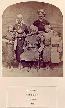
Kodava tribe and other Kodava language speakers
According to Karnataka Kodava Sahitya Academy (Karnataka's Kodava Literary Academy), apart from Kodavas, and their related groups, the Amma Kodavas, the Kodava Peggade (Kodagu Heggade) and the Kodava Maaple (Kodava Muslims), 18 other smaller-numbered ethnic groups speak Kodava Takk in and outside the district including the Iri (Airi, or the carpenters and the village smiths), the Koyava, the Banna, the Kodagu Madivala (washermen), the Kodagu Hajama (barber, also called Nainda), the Kembatti Poleya (household servants and labourers) and the Meda (basket and mat weavers and drummers).[25]
Among other Kodava speaking communities are: the Heggades, cultivators from shimogga; the Kodava Nair, cultivators from Malabar; the Ayiri, who constitute the artisan caste; the Medas, who are basket and mat-weavers and act as drummers at feasts; the Binepatta, originally wandering musicians from Malabar, now farmers; and the Kavadi, cultivators settled in Yedenalknad (Virajpet). All these groups speak the Kodava language and conform generally to Kodava customs and dress.[24]
Kodagu Aarebashe Gowda
Less frequent are Tulu speakers Billavas, Mogaveeras, Bunts, Goud Saraswat Brahmins.[25]
The Arebhashe gowdas,[26] or Kodagu Gowdas, and Tulu Gowdas, are an ethnic group of Dakshina Kannada and Kodagu. They live in Sulya (in Dakshina Kannada) and in parts of Somwarpet, Kushalanagar, Bhagamandala and Madikeri. They speak a language known as Arebhashe a dialect of Kannada. Guddemane Appaiah Gowda along with many other freedom fighters from different communities revolted against the British in an armed struggle which covered entire Kodagu and Dakshina Kannada. This was one of the earliest freedom movements against the British[27] called "Amara Sulliada Swantantrya Sangraama"[28] (Amara Sulya Dhange[27] formally called the 'Coorg Rebellion' by the British) started in 1837.[29][30][31][32]
Religion
Hindus are the vast majority. They include the Kodava tribe, other Kodava language speakers, Arebhashe Gowdas, Brahmins, most Yeravas and Kurubas.
A huge minority of Muslims dot the Coorg district, especially the towns of Kushalnagar, Virajpet and Mercara. A sizeable of them are the Nawayaths who shifted in the eighties from Bhatkal and Murdeshwar in order to pursue coffee & arecanut plantations and textile business. The numerous mosque dotting the landscape is the testimony of Muslim presence in the district.
A small number of Mangalorean Catholics are also found in Coorg.[quantify] They are mostly descended from those Konkani Catholics who fled the roundup and, later, captivity by Tippu Sultan. These immigrants were welcomed by Raja Veerarajendra (himself a former captive of Tippu Sultan, having escaped six years of captivity in 1788) who realising their usefulness and expertise as agriculturists, gave them lands and tax breaks and built a church for them.[34]
| Year | Pop. | ±% p.a. |
|---|---|---|
| 1901 | 180,607 | — |
| 1911 | 174,976 | −0.32% |
| 1921 | 163,838 | −0.66% |
| 1931 | 163,327 | −0.03% |
| 1941 | 168,726 | +0.33% |
| 1951 | 229,405 | +3.12% |
| 1961 | 322,829 | +3.48% |
| 1971 | 378,291 | +1.60% |
| 1981 | 461,888 | +2.02% |
| 1991 | 488,455 | +0.56% |
| 2001 | 548,561 | +1.17% |
| 2011 | 554,519 | +0.11% |
| source:[35] | ||
Tourism


Kodagu is rated as one of the top hill station destinations in India. Some of the most popular tourist attractions in Kodagu include Talakaveri, Bhagamandala, Nisargadhama, Abbey Falls, Dubare, Nagarahole National Park, Iruppu Falls, and the Tibetan Buddhist Golden Temple.[36]
- Talakaveri is the place where the River Kaveri originates.[37] The temple on the riverbanks here is dedicated to Lord Brahma, and is one of only two temples dedicated to Brahma in India and Southeast Asia. Bhagamandala is situated at the Sangama (confluence) of two rivers, the Kaveri and the Kannika. A third river, the Sujyothi, is said to join from underground, and hence this spot is called the Triveni Sangama. Iruppu Falls is a sacred Kodagu Hindu spot in South Kodagu in the Brahmagiri hill range. The Lakshmana Tirtha River, with the waterfalls, flows nearby and has a Rameshwara temple on its banks. It is said that this sacred river was created when Laxmana, prince of Ayodhya and younger brother of Lord Rama, shot an arrow into nearby hill, the Brahmagiri hill. Chelavara falls and Thadiandamol peak are also in South Kodagu. Nagarahole is a national park and wildlife resort.
- Madikeri is the capital of the district and Raja's Seat park is popular with tourists.[38] Kootu Poley dam is also popular among tourists. Omkareshwara Temple is a beautiful temple built in the Indo-Sarcenic style in Coorg. A legend is associated with the temple, built by Lingarajendra II in 1820 CE. The king put to death a pious Brahmin who dared to protest against his misdeeds. The spirit of the dead man began to plague the king day and night. On the advice of wise men, the king built this temple and installed a Shivalinga procured from Kashi, North India. St. Mark's Church is located within the Mercara Fort and was raised in 1859, by the officers and men of the East India Company. The building was funded by the Government of Madras,[39] and placed under the Church of England in India, Diocese of Madras.[40] The Church was closed after Indian independence, and taken over by the Government of Karnataka in 1971.[41] The building now houses the Madikeri Fort Museum, managed by the Karnataka State Archaeological Department.[42]
- Dubare is mainly an elephant-capturing and training camp of the Forest Department at the edge of Dubare forest; on the bank of the river Kaveri along the Kushalanagara – Siddapura road.[43] Nisargadhama is a man-made island and picnic spot near Kushalanagara, formed by the river Kaveri. The Tibetan Buddhist Golden Temple is at Bylakuppe near Kushalnagara (Mysore district), in the Tibetan refugee settlement.
- Abbey Falls is a scenic waterfall 5 km from Madikeri. Mallalli falls is 25 km from Somawarapet, downhill of the Pushpagiri hills.[44] Mandalapatti is 28 km from Madikeri. On the way to Abbey Falls, before 3 km from Abbey Falls take right, from there 25 km. Kote Betta temple, Kote Abbey falls are also in North Kodagu. Abbi waterfall and other waterfalls are best during monsoon season, typically some days after it starts raining in June up to the end of rainy season, while there is more water gushing in the streams and rivers.[45]
Notable people
- K. G. Bopaiah, 18th Speaker of the Karnataka Legislative Assembly
- A. S. Bopanna, Judge of Supreme court
- Daisy Bopanna, actress
- Rohan Bopanna, Indian tennis player
- K. C. Cariappa, Air Marshal
- K. C. Cariappa, professional cricketer
- Field Marshal K. M. Cariappa, first Indian C-in-C, fourth Indian High Commissioner to Australia and New Zealand
- Prema Cariappa, first woman Mayor of Bangalore, Rajya Sabha MP
- Shwetha Chengappa, actress
- Squadron Leader Ajjamada Boppayya Devayya, martyred in Indo-Pak war of 1965
- Saleem Farook, tribal rights activist
- M. P. Ganesh, Indian hockey captain, player and coach
- Kodagina Gowramma, noted writer
- B. B. Ashok Kumar, Retd. Assistant Commissioner of Police of Bengaluru
- Rashmika Mandanna, actress
- Rao Bahadur Pemmanda K. Monnappa, first Inspector General of Police of Hyderabad State following Operation Polo
- C. B. Muthamma, first woman officer Indian Foreign Service
- Lieutenant General Biddanda Chengappa Nanda, GOC-in-C Northern Command, Karnataka Rajyaotsava Awardee
- Ashwini Ponnappa, Indian badminton player
- Lieutenant General C.B. Ponnappa, Adjutant General of the Indian Army.
- Prema, actress
- Appachu Ranjan, politician
- Nidhi Subbaiah, actress
- General Kodandera Subayya Thimayya, head of Indian Army, chairman of Korean Repatriation Committee, head of UN Peacekeeping force
- Robin Uthappa, Indian Cricketer
- Lieutenant General Pattacheruvanda C. Thimayya, former General Officer in the Indian Army
See also
- Pushpagiri Wildlife Sanctuary
References
- "Kodagu district Profile". DSERT. Retrieved 11 January 2011.
- "Kodagu District Population Census 2011-2021, Karnataka literacy sex ratio and density".
- Chisholm, Hugh, ed. (1911). . Encyclopædia Britannica. Vol. 7 (11th ed.). Cambridge University Press. pp. 91–92.
- Kushalappa, Mookonda (2013). Long ago in Coorg. USA. pp. 356–365. ISBN 9781494282479.
- "Districts of India". Government of India. Retrieved 11 January 2011.
- "Codava National Council sets up global forum". The Hindu. Archived from the original on 3 January 2013.
{{cite news}}: CS1 maint: unfit URL (link) - "Dharna staged for Kodagu State". The Hindu. Archived from the original on 3 January 2013.
{{cite news}}: CS1 maint: unfit URL (link) - Kushalappa, Mookonda (2013). The early Coorgs. Chennai: Notion Press. ISBN 9789383808274.
- A Shreedhara Menon, A Survey of Kerala history
- District Census Handbook, Kasaragod (2011) (PDF). Thiruvananthapuram: Directorate of Census Operation, Kerala. p. 9.
- Government of India (2014–15). District Census Handbook – Wayanad (Part-B) 2011 (PDF). Directorate of Census Operations, Kerala.
- "When Kodagu merged with Mysore: A short political history of the region". The News Minute. 12 August 2020.
- Kushalappa, Mookonda (2018). 1785 Coorg. Madikeri, Kodagu: Codava Makkada Coota. ISBN 9788192914220.
- Kushalappa, Mookonda (2018). Kodagu principality vs British Empire. Madikeri, Kodagu: Codava Makkada Coota. ISBN 9788192914213.
- Kushalappa, Mookonda Nitin (2018). Kodagu principality vs British Empire. Madikeri, Kodagu: Codava Makkada Coota. pp. 64–81. ISBN 9788192914213.
- Belliappa, C P (4 August 2015). "Call for freedom from a tiny village". Deccan Herald. No. Bangalore. Retrieved 7 August 2015.
- Kushalappa, Mookonda Nitin (2018). Kodagu principality vs British Empire. Madikeri, Kodagu: Codava Makkada Coota. pp. 81–88. ISBN 9788192914213.
- Kushalappa, Mookonda (2014). Long ago in Coorg. Chennai: Pothi books. pp. 170–319. ISBN 9788192914206.
- "District Census - Kodagu" (PDF). Office of Registrar General and Census Commissioner, India.
- US Directorate of Intelligence. "Country Comparison:Population". Archived from the original on 13 June 2007. Retrieved 1 October 2011.
Solomon Islands 571,890 July 2011 est.
- "2010 Resident Population Data". U. S. Census Bureau. Archived from the original on 23 August 2011. Retrieved 30 September 2011.
Wyoming 563,626
- "Table C-16 Population by Mother Tongue: Karnataka". Census of India. Registrar General and Census Commissioner of India.
- "Arebhashe: Language with rich cultural history". News Karnataka. 25 August 2021. Retrieved 8 June 2022.
- K S Rajyashree, Kodava speech community : An ethnolinguistic study
- "Will Kodava find a place in Eighth Schedule". The Hindu. Archived from the original on 3 January 2013.
{{cite news}}: CS1 maint: unfit URL (link) - Herbert Feis (December 1926). "The Mechanism of Adjustment of International Trade Balances". The American Economic Review. American Economic Association. 16 (4): 593–609. JSTOR 1.
- Archived 17 December 2007 at the Wayback Machine
- South Kanara, 1799–1860 By N. Shyam Bhatt
- "The Hindu : Karnataka / Madikeri News : Appaiah Gowda's feats to be remembered". www.thehindu.com. Archived from the original on 12 August 2014. Retrieved 2 February 2022.
- "The Hindu : Karnataka / Madikeri News : Appaiah Gowda memorial to honour freedom fighter". www.hindu.com. Archived from the original on 4 June 2011. Retrieved 11 January 2022.
- "Account of an uprising". Deccan Herald. 4 March 2013.
- "Fate of the insurgents". Deccan Herald. 4 March 2013.
- "C-1 Population By Religious Community - Karnataka". Census of India.
- Sarasvati's Children: A History of the Mangalorean Christians, Alan Machado Prabhu, I.J.A. Publications, 1999, p. 229
- Decadal Variation In Population Since 1901
- "Tourists throng favourite destinations to welcome 2020". Deccan Herald. 31 December 2019.
- "Archived copy" (PDF). Archived from the original (PDF) on 11 March 2017. Retrieved 27 January 2020.
{{cite web}}: CS1 maint: archived copy as title (link) - "Maps, Weather, and Airports for Madikeri, India". www.fallingrain.com.
- Penny, Frank (1922). The Church in Madras: being the History of the Ecclesiastical and Missionary Action of the East India Company in the Presidency of Madras From 1835 to 1861: Volume III. London: John Murray. p. 98. Retrieved 14 August 2015.
- "Churches Vested in The Crown: Diocese of Madras". Lords Sitting of 31 May 1927. 67 (5): cc650-1. Retrieved 20 August 2015.
- "Museums in Karnataka". Government of Karnataka: Department of Archaeology, Museums and Heritage. 2015. Archived from the original on 18 October 2015. Retrieved 21 August 2015.
- Madur (13 October 2014). "Madikeri Fort, Coorg". Karnataka. Retrieved 20 August 2015.
- "[Jungle Lodges and Resorts Ltd]-[Wildlife and Adventure Ecotourism Destination]". Archived from the original on 4 June 2012. Retrieved 27 January 2020.
- "Abbey falls: A tourist's delight". Archived from the original on 4 October 2018. Retrieved 27 January 2020.
- "A trip to Coorg during Monsoon". Trayaan. 29 July 2016. Retrieved 5 October 2016.
Further reading
- Government of Coorg (1953), Handbook of Coorg Census-1951 (PDF), Assistant Commissioner and District Census Officer, Coorg
- Belliappa, C. P. Tale of a Tiger's Tail & Others Yarns from Coorg. English.
- Belliappa, C. P. Victoria Gowramma. English.
- Bopanna, P. T. Kodagu: Mungaru Maleya Vismayada Nadu/ Discover Coorg. Kannada/ English.
- Bopanna, P. T. Coorg State: Udaya-Pathana / Coorg State. Kannada/ English.
- Ganapathy, B. D. Kodagu mattu Kodavaru. Kannada. 1962.
- Ganapathy, B. D. Nanga Kodava. Kodava. 1973.
- Kushalappa, Mookonda. “The early Coorgs”. Chennai: Notion Press. 2013.
- Kushalappa, Mookonda. “Long ago in Coorg”. Chennai: Pothi books. 2014.
- Murphy, Dervla. On a Shoestring to Coorg.
- Puttur Anantharaja Gowda (2015). IN PURSUIT OF OUR ROOTS Bengaluru: Tenkila Publications
- N Prabhakaran. Kutaku kurippukal (Coorg Notes). Kannur: Kairali Books.
External links
- Kodagu district at Curlie
- Kodagu district website
Capital: Bengaluru | |||||||||
| State symbols |
| ||||||||
| Overviews |
| ||||||||
| History |
| ||||||||
| Districts and divisions |
| ||||||||
| Geography |
| ||||||||
| Culture |
| ||||||||
| Literature |
| ||||||||
| Noted poets |
| ||||||||
| People and society |
| ||||||||
| Tourism |
| ||||||||
| Awards |
| ||||||||
| Media |
| ||||||||
| Proposed states |
|  |
|---|---|---|
| Proposed union territories |
| |
Current states and union territories of India | ||
На других языках
[de] Kodagu (Distrikt)
Der Distrikt Kodagu (Kannada: ಕೊಡಗು ಜಿಲ್ಲೆ Koḍagu), früher anglisiert Coorg, ist ein Distrikt des indischen Bundesstaates Karnataka. Verwaltungszentrum ist die Stadt Madikeri.- [en] Kodagu district
[ru] Кодагу
Кодагу (канн. ಕೊಡಗು; англ. Kodagu) или Кург (англ. Coorg) — округ в индийском штате Карнатака. Расположен на восточном склоне Западных Гхатов. Административный центр — город Мадикери. Площадь округа — 4102 км². По данным всеиндийской переписи 2001 года население округа составляло 548 561 человек. Уровень грамотности взрослого населения составлял 78 %, что выше среднеиндийского уровня (59,5 %). Доля городского населения составляла 13,7 %.Другой контент может иметь иную лицензию. Перед использованием материалов сайта WikiSort.org внимательно изучите правила лицензирования конкретных элементов наполнения сайта.
WikiSort.org - проект по пересортировке и дополнению контента Википедии