world.wikisort.org - USA
Pike County is a county located in the U.S. state of Pennsylvania. As of the 2020 census, the population was 58,535.[1] Its county seat is Milford.[2]
Pike County | |
|---|---|
U.S. county | |
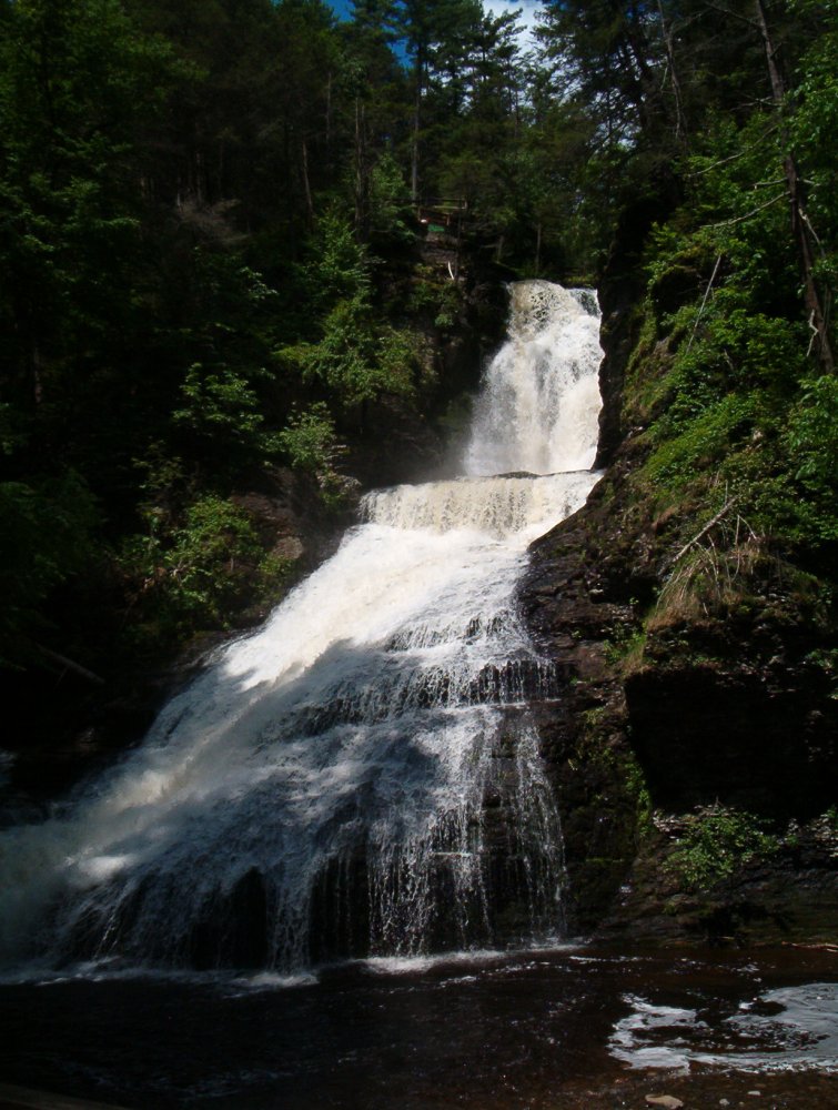 Dingmans Falls in the Delaware Water Gap National Recreation Area | |
 Seal | |
 Location within the U.S. state of Pennsylvania | |
 Pennsylvania's location within the U.S. | |
| Coordinates: 41°20′N 75°02′W | |
| Country | |
| State | |
| Founded | March 8, 1814 |
| Named for | Zebulon Pike |
| Seat | Milford |
| Largest city | Matamoras |
| Area | |
| • Total | 567 sq mi (1,470 km2) |
| • Land | 545 sq mi (1,410 km2) |
| • Water | 22 sq mi (60 km2) 3.9%% |
| Population (2020) | |
| • Total | 58,535 |
| • Density | 103/sq mi (40/km2) |
| Time zone | UTC−5 (Eastern) |
| • Summer (DST) | UTC−4 (EDT) |
| Congressional district | 8th |
| Website | www |

Pike County is included in the New York-Newark-Jersey City, NY-NJ-PA Metropolitan Statistical Area.
In 2006, Pike County was the fastest-growing county in the state of Pennsylvania.[3]
History
Pike County was named for General Zebulon Pike. It was organized on March 26, 1814 from part of Wayne County, Pennsylvania. Some English settlement in the area had started during the colonial years.
The longtime original inhabitants were the Lenape Native Americans, known by the English colonists as the Delaware Indians because their territory was along the Delaware River (as named by the colonists), as well as the coastal mid-Atlantic area. In 1694, Governor Benjamin Fletcher of the colony of New York sent Captain Arent Schuyler to investigate claims that the French were recruiting Indian allies for use against the English. In 1696, governor Fletcher authorized purchases of Indian land near the New York border by a number of citizens of Ulster County; their descendants became the first European settlers of what became Pike County.
Nicholas Depui was the first to settle in the area, in 1725. Thomas Quick moved to the area that would become Milford in 1733. Andrew Dingman settled on the Delaware River at the future site of Dingmans Ferry in 1735. The early settlers got along well with the Lenape and traded with them. As settlement increased and their land practices encroached on Lenape uses, land disputes arose. The colonists' infamous Walking Purchase of 1737 swindled the Lenape out of more than half of present-day Pike County. As the Lenape realized what had happened, violent conflicts arose between them and the colonists.
Early in the nineteenth century, coal was discovered nearby in the area that would become Carbondale. This became especially significant as the British restricted export of British coal to the United States after the War of 1812, creating a fuel shortage in rapidly expanding New York City. To get the coal to New York, developers proposed a gravity railroad from Carbondale to Honesdale, along with a canal from Honesdale to the Hudson River at Kingston.
The state of New York approved the canal proposal in 1823. Work on the 108-mile (174 km) Delaware and Hudson Canal began in 1825 and was completed in 1828. The canal system, which terminated at the Hudson River near present-day Kingston, proved profitable. But the barges had to cross the Delaware via a rope ferry across a "slackwater dam," which created bottlenecks in the canal traffic and added greatly to the cost of transportation.
John Roebling proposed continuing the canal over the river as part of an aqueduct. Built in 1848, his innovative design required only three piers, where five would ordinarily have been required; this allowed ice floes and timber rafts to pass under with less damage to the bridge. Three other suspension aqueducts were subsequently built for the canal. Roebling's Delaware Aqueduct is still standing, possibly the oldest suspension bridge in America; it has been named a National Historic Landmark.
For fifty-one years, coal flowed to New York City via the canal. But the development of railroads, which were faster, cheaper, and operated even when the canals were frozen, brought the end of the canal era. The New York and Erie Railroad supplanted the canal and in 1898 the water route was abandoned.
From 1904 to 1926, Grey Towers in the borough of Milford, Pennsylvania was the site of summer field study sessions for the Master's program of the Yale School of Forestry, together with the Forester's Hall, a commercial building that was adapted and expanded for this purpose.[4]
In 1926, PPL Corporation built a hydroelectric plant on Wallenpaupack creek at the former village of Wilsonville. The town was evacuated and now lies under Lake Wallenpaupack, created by a dam. A crew of 2,700 men worked for two years to complete the dam for the project at a cost of $1,026,000. This required the acquisition of nearly a hundred properties, and a number of farms, barns, and homes were razed or moved. In addition, 17 miles (27 km) of roads and telephone lines were relocated, and a cemetery was moved to make way for the project.
The largely rural area of the county made it attractive as a country destination. Several camps were developed in the area of Milford, Pennsylvania, the county seat. It has several hundred late 19th and early 20th-century buildings that contribute to a National Historic District listed on the National Register of Historic Places. Yale ran summer field studies for its Master's program in forestry there from 1904 to 1926.
Since the late 20th century, Pike County has been the fastest-growing county in Pennsylvania; between 1990 and 2000, its population increased by 65.2%, and it grew an additional 16.9% between 2000 and 2004. The area has relatively low state and county taxes, and affordable housing. Interstate 80 and Interstate 84 provide rapid commutes to New York City's northern suburbs.
Geography
According to the U.S. Census Bureau, the county has a total area of 567 square miles (1,470 km2), of which 545 square miles (1,410 km2) is land and 22 square miles (57 km2) (3.9%) is water.[5]
The terrain rises rapidly from the river valley in the east to the rolling foothills of the Poconos in the west. The highest point is one of two unnamed hills in Greene Township that top out at approximately 2,110 feet (643 m) above sea level.[6] The lowest elevation is approximately 340 feet (103.6 m), at the confluence of the Bushkill and the Delaware rivers.
Adjacent counties
- Sullivan County, New York (northeast)
- Orange County, New York (east)
- Sussex County, New Jersey (east)
- Warren County, New Jersey (southeast)
- Monroe County (southwest)
- Wayne County (northwest)
Climate
Pike County has a humid continental climate that is warm-summer (Dfb), except along the Delaware River from Dingmans Ferry downriver, where it is hot-summer (Dfa). The hardiness zones are 5b and 6a. Average monthly temperatures in Milford range from 25.6 °F in January to 71.3 °F in July, while in Greentown they average from 22.8 °F in January to 68.5 °F in July.
National protected areas
- Delaware Water Gap National Recreation Area (part)
- Middle Delaware National Scenic River (part)
- Upper Delaware Scenic and Recreational River (part)
State protected areas
- Delaware State Forest (part)
- Promised Land State Park
Major highways
 I-84
I-84 US 6
US 6 US 206
 US 209
 PA 191
 PA 390
 PA 402
 PA 434
 PA 447
 PA 507
 PA 590
 PA 739
Demographics
| Historical population | |||
|---|---|---|---|
| Census | Pop. | %± | |
| 1820 | 2,894 | — | |
| 1830 | 4,843 | 67.3% | |
| 1840 | 3,832 | −20.9% | |
| 1850 | 5,881 | 53.5% | |
| 1860 | 7,155 | 21.7% | |
| 1870 | 8,436 | 17.9% | |
| 1880 | 9,663 | 14.5% | |
| 1890 | 9,412 | −2.6% | |
| 1900 | 8,766 | −6.9% | |
| 1910 | 8,033 | −8.4% | |
| 1920 | 6,818 | −15.1% | |
| 1930 | 7,483 | 9.8% | |
| 1940 | 7,452 | −0.4% | |
| 1950 | 8,425 | 13.1% | |
| 1960 | 9,158 | 8.7% | |
| 1970 | 11,818 | 29.0% | |
| 1980 | 18,271 | 54.6% | |
| 1990 | 27,966 | 53.1% | |
| 2000 | 46,306 | 65.6% | |
| 2010 | 57,369 | 23.9% | |
| 2020 | 58,535 | 2.0% | |
As of the 2010 census, there were 57,369 people living in the county. The county was 88.6% Non-Hispanic White, 6.3% Black or African American, 0.5% Native American, 1.2% Asian, and 1.7% were two or more races. 10.2% of the population were of Hispanic or Latino ancestry.[7]
As of the census[8] of 2000, there were 46,302 people, 17,433 households, and 13,022 families living in the county. The population density was 85 inhabitants per square mile (33/km2). There were 34,681 housing units at an average density of 63 per square mile (24/km2). The racial makeup of the county was 93.10% White, 3.27% Black or African American, 0.24% Native American, 0.62% Asian, 0.01% Pacific Islander, 1.30% from other races, and 1.47% from two or more races. 5.00% of the population were Hispanic or Latino of any race. 18.9% were of German, 18.6% Irish, 18.5% Italian, 6.2% English and 5.3% Polish ancestry.
There were 17,433 households, out of which 34.40% had children under the age of 18 living with them, 63.50% were married couples living together, 7.60% had a female householder with no husband present, and 25.30% were non-families. 20.70% of all households were made up of individuals, and 8.40% had someone living alone who was 65 years of age or older. The average household size was 2.63 and the average family size was 3.06.
In the county, the population was spread out, with 26.70% under the age of 18, 5.30% from 18 to 24, 27.70% from 25 to 44, 25.10% from 45 to 64, and 15.20% who were 65 years of age or older. The median age was 40 years. For every 100 females, there were 99.30 males. For every 100 females age 18 and over, there were 97.30 males.
As of Q4 2021, the median home value of all homes in Pike County is $214,981.[9]
2020 Census
| Race | Num. | Perc. |
|---|---|---|
| White (NH) | 45,375 | 77.5% |
| Black or African American (NH) | 3,027 | 5.2% |
| Native American (NH) | 121 | 0.21% |
| Asian (NH) | 841 | 1.43% |
| Pacific Islander (NH) | 14 | 0.02% |
| Other/Mixed (NH) | 2,438 | 4.16% |
| Hispanic or Latino | 6,719 | 11.5% |
Politics and government
| Year | Republican | Democratic | Third party | |||
|---|---|---|---|---|---|---|
| No. | % | No. | % | No. | % | |
| 2020 | 19,213 | 59.02% | 13,019 | 39.99% | 322 | 0.99% |
| 2016 | 16,056 | 61.09% | 9,256 | 35.22% | 972 | 3.70% |
| 2012 | 12,786 | 54.93% | 10,210 | 43.86% | 283 | 1.22% |
| 2008 | 12,518 | 51.55% | 11,493 | 47.33% | 273 | 1.12% |
| 2004 | 12,444 | 58.43% | 8,656 | 40.64% | 199 | 0.93% |
| 2000 | 9,339 | 53.78% | 7,330 | 42.21% | 695 | 4.00% |
| 1996 | 6,697 | 47.02% | 5,509 | 38.68% | 2,038 | 14.31% |
| 1992 | 6,084 | 44.73% | 4,382 | 32.21% | 3,137 | 23.06% |
| 1988 | 6,659 | 67.15% | 3,097 | 31.23% | 161 | 1.62% |
| 1984 | 6,343 | 71.17% | 2,503 | 28.08% | 67 | 0.75% |
| 1980 | 5,249 | 65.83% | 2,132 | 26.74% | 592 | 7.43% |
| 1976 | 4,241 | 59.35% | 2,775 | 38.83% | 130 | 1.82% |
| 1972 | 4,568 | 74.79% | 1,385 | 22.68% | 155 | 2.54% |
| 1968 | 3,719 | 64.23% | 1,617 | 27.93% | 454 | 7.84% |
| 1964 | 2,651 | 48.86% | 2,753 | 50.74% | 22 | 0.41% |
| 1960 | 4,000 | 70.39% | 1,676 | 29.49% | 7 | 0.12% |
| 1956 | 4,160 | 77.28% | 1,219 | 22.65% | 4 | 0.07% |
| 1952 | 3,810 | 73.21% | 1,383 | 26.58% | 11 | 0.21% |
| 1948 | 2,893 | 70.54% | 1,208 | 29.46% | 0 | 0.00% |
| 1944 | 2,674 | 65.20% | 1,408 | 34.33% | 19 | 0.46% |
| 1940 | 2,596 | 58.63% | 1,818 | 41.06% | 14 | 0.32% |
| 1936 | 2,304 | 48.60% | 2,396 | 50.54% | 41 | 0.86% |
| 1932 | 1,649 | 46.35% | 1,844 | 51.83% | 65 | 1.83% |
| 1928 | 2,354 | 69.34% | 1,024 | 30.16% | 17 | 0.50% |
| 1924 | 1,581 | 54.20% | 993 | 34.04% | 343 | 11.76% |
| 1920 | 1,319 | 58.05% | 880 | 38.73% | 73 | 3.21% |
| 1916 | 598 | 37.19% | 976 | 60.70% | 34 | 2.11% |
| 1912 | 191 | 11.49% | 995 | 59.83% | 477 | 28.68% |
| 1908 | 715 | 39.24% | 1,069 | 58.67% | 38 | 2.09% |
| 1904 | 592 | 37.59% | 942 | 59.81% | 41 | 2.60% |
| 1900 | 694 | 35.30% | 1,236 | 62.87% | 36 | 1.83% |
| 1896 | 778 | 40.10% | 1,123 | 57.89% | 39 | 2.01% |
| 1892 | 477 | 28.87% | 1,150 | 69.61% | 25 | 1.51% |
| 1888 | 559 | 30.38% | 1,265 | 68.75% | 16 | 0.87% |
As of November 2008, there were 45,753 registered voters in Pike County.[12]
- Republican: 20,087 (43.90%)
- Democratic: 16,967 (37.08%)
- Other Parties: 8,699 (19.01%)
The Republican Party has been historically dominant in county-level politics. For statewide and national-level candidates, Pike County has leaned toward the Republican Party. In 2000 Republican George W. Bush won 53% to Democrat Al Gore's 42%. In 2004 Republican George W. Bush won 58% to Democrat John Kerry's 40%. In 2008 Republican John McCain won 51% to Democrat Barack Obama's 47%. But, due to population growth, new residents have led an increase in Democratic voting. In 2006, Democratic Governor Ed Rendell won Pike with 53%. Of the four statewide Democratic candidates in the 2008 election, the only one to carry Pike was Jack Wagner.
County Commissioners
- Ron Schmalzle, ViceChairman, Republican
- Matthew M. Osterberg, Chairman, Republican
- Steve Guccini, Democrat
Other county offices
- Clerk of Courts and Prothonotary, Denise Fitzpatrick, Republican
- Coroner, Christopher P. Brighton, Republican [13]
- District Attorney, Raymond Tonkin, Republican
- Recorder of Deeds and Register of Wills, Sharon Schroeder, Republican
- Sheriff, Kerry Welsh
- Treasurer, John Gilpin, Republican
State Representatives[14]
- Michael Peifer, Republican (139th district) - Blooming Grove, Dingman (partially), Greene, Lackawaxen, Milford, Palmyra, Shohola, and Westfall Townships, and Matamoras and Milford Boroughs
- Rosemary Brown, Republican (189th district) - Delaware, Dingman (partially), Lehman, and Porter Townships
State Senator[14]
- Lisa Baker, Republican (20th district)
United States Representative
- Matt Cartwright, Democrat (PA-8)
United States Senate
- Pat Toomey, Republican
- Bob Casey, Jr., Democrat
Education
Public school districts
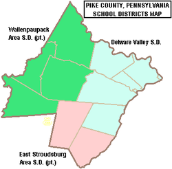
- Delaware Valley School District
- East Stroudsburg Area School District (also in Monroe County)
- Wallenpaupack Area School District (also Wayne County)
In 2011, Porter Township residents successfully petitioned the Pennsylvania Secretary of Education to transfer the township from East Stroudsburg Area School District to Wallenpaupack Area School District. The appeal by East Stroudsburg Area School District was heard by the Commonwealth Court in April 2012.
Private
- Center for Developmental Disabilities of Pike Co, Ltd. – Milford
- New Life Christian Day School – Matamoras
- Sunshine Academy – Milford
- Kinderhaus Montessori of PA – Milford
Communities
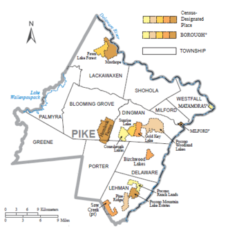
Under Pennsylvania law, there are four types of incorporated municipalities: cities, boroughs, townships, and, in at most two cases, towns. The following boroughs and townships are located in Pike County:
Boroughs
Townships
Census-designated places
Population ranking
The population ranking of the following table is based on the 2020 census of Pike County.[15]
† county seat
| Rank | City/Town/etc. | Municipal type | Population (2020 Census) |
|---|---|---|---|
| 1 | Saw Creek | CDP | 4,016 |
| 2 | Hemlock Farms | CDP | 3,271 |
| 3 | Pocono Woodland Lakes | CDP | 3,209 |
| 4 | Pine Ridge | CDP | 2,707 |
| 5 | Matamoras | Borough | 2,362 |
| 6 | Gold Key Lake | CDP | 1,830 |
| 7 | Sunrise Lake | CDP | 1,387 |
| 8 | Birchwood Lakes | CDP | 1,386 |
| 9 | Conashaugh Lakes | CDP | 1,294 |
| 10 | Pocono Ranch Lands | CDP | 1,062 |
| 11 | † Milford | Borough | 1,103 |
| 12 | Pocono Mountain Lake Estates | CDP | 842 |
| 13 | Fawn Lake Forest | CDP | 755 |
| 14 | Masthope | CDP | 685 |
Notable natives and residents
- Louis Allen, a New York Army National Guard officer killed in a fragging incident in 2005 during the Iraq War.
- James Blish, Damon Knight, Judith Merril and Kate Wilhelm (Mrs. Knight), all science fiction writers]
- Vanessa Carlton - (born 1980) singer/songwriter
- Zane Grey - (1872-1939) author of western stories and novels including Riders of the Purple Sage
- Allyn Joslyn, stage and screen actor
- Robert Litzenberger, professor emeritus at the Wharton School of the University of Pennsylvania
- Frank McCourt, author
- Charles Sanders Peirce, a philosopher and polymath, lived on a farm 3 miles from Milford, from 1887 until his 1914 death.
- Mary Pickford, silent film actress
- Gifford Pinchot - (1865–1946) was the first Chief of the United States Forest Service (1905–1910) and the Governor of Pennsylvania (1923–1927, 1931–1935).
- Al Pitrelli, guitarist
- Tom Quick, early settler[16]
- Mary Cole Walling (1838–1925), patriot, lecturer
- Smoky Joe Wood, baseball pitcher.[17]
- Marie Zimmermann designer and maker of jewelry and metalwork
See also
- National Register of Historic Places listings in Pike County, Pennsylvania
- Camp Tamiment
References
- "State & County QuickFacts". United States Census Bureau. Archived from the original on June 6, 2011. Retrieved November 20, 2013.
- "Find a County". National Association of Counties. Retrieved June 7, 2011.
- https://www.census.gov/popest/counties/CO-EST2006-08.html Archived copy at the Library of Congress (June 10, 2010).
- "National Historic Landmarks & National Register of Historic Places in Pennsylvania". CRGIS: Cultural Resources Geographic Information System. Archived from the original (Searchable database) on July 21, 2007. Retrieved October 9, 2013. Note: This includes Betz Steiner; Leon Husson & Carson O. Helfrich (December 1982). "National Register of Historic Places Inventory Nomination Form: Forester's Hall" (PDF). Archived from the original (PDF) on November 9, 2013. Retrieved May 30, 2012.
- "2010 Census Gazetteer Files". United States Census Bureau. August 22, 2012. Retrieved March 10, 2015.
- Highest point located behind Panther Lodging on Route 447 Map of Terrain
- https://www.census.gov/quickfacts/table/PST045215/42103,42 [dead link]
- "U.S. Census website". United States Census Bureau. Retrieved January 31, 2008.
- "County Median Home Price". National Association of Realtors. Archived from the original on April 15, 2022. Retrieved April 14, 2022.
- "P2 HISPANIC OR LATINO, AND NOT HISPANIC OR LATINO BY RACE – 2020: DEC Redistricting Data (PL 94-171) – Pike County, Pennsylvania".
- Leip, David. "Dave Leip's Atlas of U.S. Presidential Elections". uselectionatlas.org.
- Running for Office. Dos.state.pa.us. Retrieved on July 15, 2013.
- "Pike County, PA".
- Center, Legislativate Data Processing. "Find Your Legislator". The official website for the Pennsylvania General Assembly. Retrieved May 9, 2017.
- CNMP, US Census Bureau. "This site has been redesigned and relocated. - U.S. Census Bureau". www.census.gov.
- Quinlan, James E. "Tom Quick The Indian Slayer and the pioneers of Minisink and Wawarsink" Monticello, N.Y.: De Voe & Quinlan, Publishers (1851)
- "Smoky Joe Wood Stats - Baseball-Reference.com". Baseball-Reference.com.
External links
- Official web site of Pike County
- Pike County Public Library*Discover Pike, PA – History of Pike County
- Pike County Chamber of Commerce
Places adjacent to Pike County, Pennsylvania | ||||||||||||||||
|---|---|---|---|---|---|---|---|---|---|---|---|---|---|---|---|---|
| ||||||||||||||||
Municipalities and communities of Pike County, Pennsylvania, United States | ||
|---|---|---|
County seat: Milford | ||
| Boroughs |  | |
| Townships | ||
| CDPs | ||
| Unincorporated communities | ||
| Footnotes | ‡This populated place also has portions in an adjacent county or counties. | |
| ||
Authority control | |
|---|---|
| General | |
| National libraries | |
| Other | |
На других языках
[de] Pike County (Pennsylvania)
Pike County[1] ist ein County im Bundesstaat Pennsylvania der Vereinigten Staaten. Bei der Volkszählung im Jahr 2020 hatte das County 58.535 Einwohner und eine Bevölkerungsdichte von 41,3 Einwohnern pro Quadratkilometer.[2] Der Verwaltungssitz (County Seat) ist Milford.- [en] Pike County, Pennsylvania
[ru] Пайк (округ, Пенсильвания)
Округ Пайк (англ. Pike County) располагается в США, штате Пенсильвания. Официально образован 8-го марта 1814 года. По состоянию на 2010 год, численность населения составляла 57 369 человек. Окружной центр — Милфорд. Получил своё название в честь американского бригадного генерала и исследователя Зебулона Пайка.Другой контент может иметь иную лицензию. Перед использованием материалов сайта WikiSort.org внимательно изучите правила лицензирования конкретных элементов наполнения сайта.
WikiSort.org - проект по пересортировке и дополнению контента Википедии