


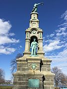
 Soldiers and Sailors Monument - Seaside Park
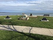 Seaside Park - Spanish American War memorial
 The beach at Seaside Park
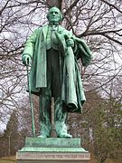 James Beardsley Monument at Beardsley Park in Bridgeport
world.wikisort.org - USA
Bridgeport is the most populous city and a major port in the U.S. state of Connecticut.[4] With a population of 148,654 in 2020,[2] it is also the fifth-most populous in New England. Located in eastern Fairfield County at the mouth of the Pequonnock River on Long Island Sound, it is 60 miles (97 km) from Manhattan and 40 miles (64 km) from The Bronx. It is bordered by the towns of Trumbull to the north, Fairfield to the west, and Stratford to the east. Bridgeport and other towns in Fairfield County make up the Bridgeport-Stamford-Norwalk-Danbury metropolitan statistical area, the second largest metropolitan area in Connecticut. The Bridgeport-Stamford-Norwalk-Danbury metropolis forms part of the New York metropolitan area.
Bridgeport, Connecticut | |
|---|---|
City | |
From top left, left to right: Downtown Bridgeport facing southeast from a parking garage, Perry Memorial Arch at Seaside Park, Beardsley Zoo, Providence Bruins vs Bridgeport Sound Tigers at the Total Mortgage Arena, Bridgeport Station, the Port Jefferson ferry dock along the Pequonnock River | |
 Flag  Seal | |
| Nicknames: The Park City | |
Mottoes:
| |
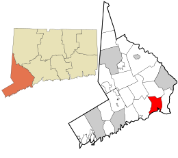 Location within Fairfield County | |
 Bridgeport Location within Connecticut  Bridgeport Location within the United States | |
| Coordinates: 41°11′11″N 73°11′44″W | |
| Country | |
| State | |
| County | Fairfield |
| Region | Metropolitan CT |
| Metropolitan area | Greater Bridgeport |
| Incorporated (town) | 1821 |
| Incorporated (city) | 1836 |
| Named for | A drawbridge over the Pequonnock River |
| Government | |
| • Type | Mayor-council |
| • Mayor | Joseph P. Ganim (D) |
| Area | |
| • City | 19.4 sq mi (50.2 km2) |
| • Land | 16.0 sq mi (41.4 km2) |
| • Water | 3.4 sq mi (8.8 km2) |
| • Urban | 465 sq mi (1,205 km2) |
| Elevation | 3 ft (1 m) |
| Population | |
| • City | 148,654 |
| • Rank | US: 172nd |
| • Density | 7,700/sq mi (3,000/km2) |
| • Urban | 923,311 (US: 48th) |
| • Metro | 939,904 (US: 57th) |
| Demonym | Bridgeporter |
| Time zone | UTC−5 (Eastern) |
| • Summer (DST) | UTC−4 (Eastern) |
| ZIP Codes | 06601–06602, 06604–06608, 06610, 06650, 06673, 06699[3] |
| Area code | 203/475 |
| FIPS code | 09-08000 |
| GNIS feature ID | 205720 |
| Website | bridgeportct |
Showman P. T. Barnum was a resident of the city and served as the town's mayor (1871).[5] Barnum built four houses in Bridgeport and housed his circus in town during winter. The city in the early 20th century saw an economic and population boom, becoming by all measures Connecticut's chief manufacturing city.[6] Bridgeport was the site of the world's first mutual telephone exchange (1877),[7] the first dental hygiene school (1949),[8] and the first bank telephone bill service in the US (1981).[9] Harvey Hubbell II invented the electric plug outlet in Bridgeport in 1912.[10] The Frisbie Pie Company was founded in Bridgeport, and the city is credited as the birthplace of the Frisbee.[11] The world's first Subway restaurant opened in the city's North End in 1965.[12] After World War II, industrial restructuring and suburbanization caused the loss of many large companies and affluent residents, leaving Bridgeport struggling with issues of poverty, violent crime, and a bad image.[13]
Since the beginning of the 21st century, Bridgeport has begun extensive redevelopment of its downtown and other neighborhoods. Bridgeport is home to 3 museums,[14] the University of Bridgeport, Housatonic Community Collage, Paier College, and part of Sacred Heart University[15][16] as well as the state's only zoo.[17]
History
Bridgeport was inhabited by the Paugussett native American tribe during the start of European colonization. The earliest European communal settlement was in the historical Stratfield district,[18] along US Route 1; known in colonial times as the King's Highway. Close by, Mount Grove Cemetery was laid out on what was a native village that extended past the 1650s.[19] It is also an ancient Paugusett burial ground.
The burgeoning farming community grew and became a center of trade, shipbuilding, and whaling. The town incorporated to subsidize the Housatonic Railroad and rapidly industrialized following the rail line's connection to the New York and New Haven railroad. The town was given its name because of the need for bridges over the Pequonnock River that provided a navigable port at the mouth of the river. Manufacturing was the mainstay of the local economy until the 1970s.
Colonial history
The first documented European settlement within the present city limits of Bridgeport took place in 1644, centered at Black Rock Harbor and along North Avenue between Park and Briarwood Avenues. The place was called Pequonnock[6] (Quiripi for "Cleared Land"), after a band of the Paugussett, an Algonquian-speaking Native American people who occupied this area. One of their sacred sites was Golden Hill, which overlooked the harbor and was the location of natural springs and their planting fields. (It has since been blasted through for construction of an expressway.)[20][21] The Golden Hill Indians were granted a reservation here by the Colony of Connecticut in 1639; it lasted until 1802. (One of the tribes acquired land for a small reservation in the late 19th century that was recognized by the state. It is retained in the Town of Trumbull.)
Bridgeport's early years were marked by residents' reliance on fishing and farming. This was similar to the economy of the Paugusset, who had cultivated corn, beans, and squash; and fished and gathered shellfish from both the river and sound. A village called Newfield began to develop around the corner of State and Water streets in the 1760s.[22] The area officially became known as Stratfield in 1695[6] or 1701, due to its location between the already existing towns of Stratford and Fairfield.[23] During the American Revolution, Newfield Harbor was a center of privateering.[21][6]
19th century

By the time of the State of Connecticut's ratification of the Articles of Confederation in 1781, many of the local farmers held shares in vessels trading at Newfield Harbor or had begun trading in their own name. Newfield initially expanded around the coasting trade with Boston, New York, and Baltimore and the international trade with the West Indies.[22][24] The commercial activity of the village was clustered around the wharves on the west bank of the Pequonnock, while the churches were erected inland on Broad Street.[25] In 1800, the village became the Borough of Bridgeport,[28] the first so incorporated in the state.[29] It was named for the Newfield or Lottery Bridge across the Pequonnock, connecting the wharves on its east and west banks.[27] Bridgeport Bank was established in 1806.[30] In 1821, the township of Bridgeport became independent of Stratford.[31]

In 1821, a small community of free blacks and runaway slaves was established in the South End along Main Street known as Little Liberia, with its own churches, schools and hotels, and served as a stop in the underground railroad. Many remaining Paugusset Indians also lived there.[32]
The West India trade died down around 1840,[22] but by that time the Bridgeport Steamship Company (1824)[33] and Bridgeport Whaling Company (1833) had been incorporated[22] and the Housatonic Railroad chartered (1836).[34][35] The HRRC ran upstate along the Housatonic Valley, connecting with Massachusetts's Berkshire Railroad at the state line. Bridgeport was chartered as Connecticut's fifth city in 1836[31][36][39] in order to enable the town council to secure funding (ultimately $150,000) to provide to the HRRC and ensure that it would terminate in Bridgeport.[40] The Naugatuck Railroad—connecting Bridgeport to Waterbury and Winsted along the Naugatuck—was chartered in 1845 and began operation four years later.[41][42] The same year, the New York and New Haven Railroad began operation,[43] connecting Bridgeport to New York and the other towns along the north shore of the Long Island Sound. Now a major junction, the city began to industrialise.
The city's first immigrants were Irish Catholics who settled in the Sterling Hill section of the Hollow. Having come to the US to escape the famine, they arrived in town during the 1830s to build the railroad. They mostly lived in wooden four to six family tenements, often subdivided homes.
In 1842, showman P.T. Barnum spent a night in Bridgeport, and there met Charles Stratton, a local dwarf. He soon became part of Barnum's act and a star under the name "General Tom Thumb". Barnum moved to Bridgeport and built four houses in the city over the course of his life, the first being Iranistan.[44]

In 1852, Barnum began an endeavor with William Noble to develop the land (inherited by Noble) on the other side of the Pequonnock River, across the river from Bridgeport to be known as "East Bridgeport" with Washington Park at the center.[45] The new neighborhood had homes, commerce, and factories, centered around East Main Street. The neighborhood eventually became the East Side of Bridgeport (occasionally spelled "Eastside").
In 1863, during the Civil War, the Bridgeport Standard ran a series of articles encouraging the creation of a public park in the city. This led wealthy residents P.T. Barnum, William Noble and Nathaniel Wheeler to purchase the land on Long Island Sound and donating the land to the city in 1864. The land on the shore became Seaside Park. A second park was built near East Main Street, when in 1878, James Beardsley donated more than 100 acres (40 ha) to the city along the Pequonnock River under the condition that the land be "kept the same forever as a public park". Both parks were designed by Frederick Law Olmsted, known for creating Central Park. These two large public parks gave Bridgeport the nickname "The Park City".[46]
The county's Roman Catholic seat, St. Augustine Cathedral was finished in 1869, built by the Irish who had arrived 30 year earlier. Saint James Church, predating the archdiocese of Hartford, was the first Roman Catholic congregation in Fairfield County, starting with 250 members in 1842. The congregation gave rise to St Augustine's in Sterling Hill, the seat of the Diocese of Bridgeport.[47]
Following the Civil War, the town held several iron foundries and factories manufacturing firearms, metallic cartridges, horse harnesses, locks, and blinds.[31] Wheeler & Wilson's sewing machines were exported throughout the world. Bridgeport annexed the West End and the village of Black Rock and its busy harbor in 1870.[48] In 1875, P. T. Barnum was elected mayor of the town, which afterwards served as the winter headquarters of Barnum and Bailey's Circus and Buffalo Bill's Wild West Show.[6] Barnum also helped establish Fairfield County's first hospital (Conn.'s 3rd) and the Bridgeport-Port Jefferson ferry, connecting the town to Long Island.[49]
Harvey Hubbell founded Hubbell Incorporated in Bridgeport in 1888. The Holmes & Edwards Silver Co. was founded in 1882, its wares sold nationally, and the company became part of the International Silver Company in 1898.[50] (The H&E brand continued well into the 1950s and was advertised in national magazines such as LIFE and Ladies' Home Journal.)[51] Hungarian immigrants began to arrive, which led to the Ráckόczi Hungarian Aid Association in Bridgeport in 1887 and the American Hungarian Immigrant Aid Society 1892. They established themselves in the West End.[52] In 1894, Bridgeport's Slavic immigrants played a major role in the development of the Orthodox Christian faith in America when they met with Fr Alexis Toth (now Saint Alexis) and founded Holy Ghost Russian Orthodox Church in the city's Eastside. This parish became the mother church of all Orthodox Churches in New England.
20th century
From 1870 to 1910, Bridgeport became the largest industrial center in Connecticut; its population rose from around 25,000 to over 100,000, including thousands of Irish, Slovaks, Hungarians, Germans, English, and Italian immigrants. Jewish migration to the city began in the 1881, with an influx of Polish, Russian, and especially Hungarian Jews calling Bridgeport home. Bridgeport Jew Edwin Land grew up to invent the Polaroid.[53]

In 1905, Bridgeport was already "the largest industrial center in the state, $49,381,348 was invested in manufacturing and the products being valued at $44,586,519." The city was a port of entry with its imports being valued at around $656,271 in 1908.[6]
The Singer factory joined Wheeler & Wilson in producing sewing machines[6] and the Locomobile Company of America was a prominent early automobile manufacturer, producing a prototype of the Stanley Steamer and various luxury cars.[54]
The town was also the center of America's corset production, responsible for 19.9% of the national total,[6] and became the headquarters of Remington Arms following its 1912 merger with the Union Metallic Cartridge Co. Around the time of the First World War, Bridgeport was also producing steam-fitting and heating apparatuses, brass goods, phonographs, typewriters,[6] milling machines, brassieres, and saddles.[55]

Brideport's Italian immigrants settled in the "Central End", today's Little Italy, and the city was the 3rd most Italian in the state by 1910. Their newspapers were the weekly La Tribuna de Connecticut (1906-1908) and later La Sentinella (1920-1948)[56][57] The West End along Wordin Avenue, known as "Hunktown", grew into one of the largest Hungarian communities in the US.[52] It was visited by Hungarian republicans trying to take down the Austro-Hungarian monarchy, in order to garner support. The West Side nearby was home to Slovenians, French-Canadians and Swedish immigrants. By 1910 Bridgeport had grown into second largest city in Connecticut at 102,052, behind New Haven.[58][6]
Between 1910 and 1920, during World War I, the city's population exploded from 102,054 to 143,555, due to the city's role in the First World War.[59] Bridgeport had the largest factory in the world at the time, the new Remington Arms plant on Boston Avenue (on the East Side). Built in 1915, it had 13 separate buildings, each of them 5 stories, connected by a long corridor half a mile long. The purpose of the building was to fulfil a company order from the Russian tzar for a million rifles and 100 million round of ammunition. The construction site was protected by the National Guard to prevent Bolshevik arson. The factory by 1916 employed 16,000 people and led to the construction of "Remington City" in the Mill Hill neighborhood, and "Remington Village" in the East End, by Remington Arms.[59]

In the summer of 1915, a series of strikes imposed the eight-hour day on the town's factories; rather than moving business elsewhere, the success spread the eight-hour day throughout the Northeast.[60] Due to housing shortages in many US cities during World War I, the federal government created the US Housing Corporation. This resulted in 7 USHC housing developments being built in Bridgeport, notably Seaside Village in the South End and Black Rock Gardens in Black Rock. By this point, Remington Arms was producing 50% of America's cartrages during the war, with 17,000 employees, and homes for new workers were needed. The factory became a General Electric plant after the war.[61] The First World War had continued the city's expansion so that, on the eve of the Great Depression, there were more than 500 factories in Bridgeport, including Columbia Records' primary pressing plant.
The 1920s saw the city's population stabilize at 143,555, after the war.[62] The decade saw the city grow with more leasure and entertainment. In 1919, the city of Bridgeport bought Pleaseure Beach (also known as Steepchase Island) for $220,000. Pleasure beach was an amusement park and beach on an island in the East End next to Stratford.[63] In 1920, the city parks commissioner began the process of creating a zoo in Beardsley Park.[64] 1922 was the year the elegantly designed Majestic and Poli Palace theatures, were built downtown, along with the Savory Hotel. The 3,600 seat Poli Palace theatre (built by Sylvester Poli) was the largest theater in the state of Connecticut, with guided hand carved moldings and vaulted cealings. Bridgeport a stop became for performances with around 20 theatures.[65] [66] The Ritz Ballroom was opened in 1923. In 1928, the city bought an 800-acre (320 ha) racetrack and landing field in Lordship to construct Bridgeport Airport.[67]


During the Great Depression the city elected Socialist party candidate Jasper McLevy as mayor in 1933. McLevy's election made headlines as a New England city had a socialist mayor. Known for cutting costs, he would serve as mayor for 12 terms, finally losing in 1957.[68]
The Great Migration led southern African-Americans to Bridgeport around the 1930s (thanks to railroads)[69] along with black foreigners (such as Cape Verdean),[69] By 1930, Bridgeport had the third largest percentage of African Americans in New England. The Italían population by 1930 had more than doubled, more than 13,000 American-born children would be born to Italians in Bridgeport.[57]
The build-up to World War II helped the city's recovery in the late 1930s. Sikorsky moved into the South Avenue plant in the 1940s.[70]
Development made its expansion into the quiet suburban North End, north of Westfield Avenue.[71] On Park Avenue in 1962 the Museam of Art, Science and Industry (MASI) was opened to the public, today's Discovery Museam and Planetarium. Known for the newly developed approach of hands on-exhibits, the Museam became science oriented later on.[14] Continued development of new suburban housing attracted middle and upper-class residents, leaving the city with a higher proportion of poor. By the 1960s, Puerto Ricans had begun to immigrate to Bridgeport in large numbers, and by about 1970 had made up 10% of the city's population.[72] Groups such as the local Young Lords branch organized themselves on East Main Street.
As cities across the country were renovating their central business district after the war, Bridgeport attempted its own urban renewal projects in its old downtown in the early 1960s during the construction of the highways. Bridgeport under Mayor Tedesco went under the 52-acre (21 ha) State Street redevelopment project,[73] demolishing 52 acres on State Street, clearing the land for development. Replaced with modern high-rise office buildings, parking, the Route 8/25 expressway towards Waterbury and Newtown, and a shopping mall at its core.[74] Large parts of Main Street were destroyed. Constructed with federal funding, on Lafayette Boulevard and Broad Street, the 450,000 acre, 2 story (with basement) Lafayette Shopping Plaza was erected, a downtown shopping mall with a Sears and a Gimbels department store as anchors connected to it.
The 12-story 855 Main Street (the first high rise in Bridgeport in decades) was built as well, and Middle Street was built the 18-floor Park City Plaza, in 1972 by the FD Rich Comeant with the hope that a major company would move in, which never occurred. The plan for three identical towers never materialized, due to finances. Bridgeport was largely bypassed by the New York companies heading to suburban Fairfield County. The block on Main Street would be demoshied and replaced with the $24 million Hotel Bridgeport Plaza, later a Holiday Inn. Much of north downtown Bridgeport would end up abandoned, neglected and boarded up as department and discount stores closed, leaving only federal and municipal buildings.[75] [76]

Restructuring of heavy industry starting after the mid-20th century caused the loss of thousands of jobs and residents. Like other urban centers in Connecticut, Bridgeport suffered during the deindustrialization of the United States in the 1970s and 1980s.[77] Pleasure Beach was sold 5 years after a rollercoaster caught fire. A year later the park closed for good.[78]
In September 1978, Bridgeport teachers went on a 19-day strike due to deadlocked contract negotiations. A court order, as well as a state law that made strikes by public workers illegal in Connecticut, resulted in 274 teachers being arrested and jailed.[79] In November 1978, a wave of arson passed through the city's East side, with the fire chief calling it as a microcosm of "the Bronx".[80] The city suffered from overall mismanagement, for which several city officials were convicted, contributing to the economic and social decline.[81]
The once busy Lafayette Shopping Plaza began to lose customers after Gimbel's closed in 1984. Replaced with a Read's store, the mall was later bought by Hi-Ho Industries and renamed "Hi-Ho Mall", until it closed in 1993 and became Housatonic Community College in 1997.[82]
Bridgeport remained the state's second city and as Hartford's population continued to shrink, Bridgeport became the largest city in Connecticut in 1974, with a population of 142,546. A 1981 Times article read; "Bridgeport... for years has suffered an image problem when compared with Hartford because of that city's role as state capital and as the site of a number of large corporations." Mayor Mandanici's response was "Hartford reported state sales taxes of $712.7 million, but Bridgeport yielded state sales taxes of $890.4 million. That's economic power, right?"[83] In 1985, Bridgeport was still Connecticut's chief manufacturing center, its major industries including General Electric, Remington Shaver, Bryant Electric, and Raybestos factories. A New York Times in 1985 stated Bridgeport was the fifth largest banking center in New England, with five of the banks based Bridgeport having assets of more than $6 billion.[13] Between 1984 and 1989 the construction of the new $75 million headquarters for People's United Bank, the second largest bank in New England. The 10-story Connecticut National Bank building was demolished and replaced with the new 18-story Bridgeport Center overlooking McLevy Square, and was designed by famous architect Richard Meier.[13] The bank establishing the first phone bank service in the US.[84][85]
In 1991, the city filed for bankruptcy protection but was declared solvent by a federal court.[86]
Bridgeport made numerous efforts at revitalization. In a proposal in 1995, Las Vegas developer Steve Wynn was to build a large casino, but that project failed due to traffic concerns.[87] The project was opposed as rival Donald Trump feared a Bridgeport casino would harm his Atlantic City properties and proposed to build a theme park and potencial casino on the same site.[87]
Later that same year, Mayor Mary C. Moran lost the election to Joseph Ganim, at 33 years old, the youngest person to hold that office. He was known for being one of the city's biggest promoters[88] and under him the city was able to begin redevelopment with the construction of the Arena at Harbor Yard and the Ballpark at Harbor Yard. In 1999, city-owned Sikorsky Memorial Airport ceased its commercial regional flight offerings.
21st century
In 2003, Mayor Ganim was involved in a corruption scandal after being investigated by the FBI as he received gifts from developers in exchange for being allowed to build in Bridgeport. He was sentenced to federal prison, and was replaced by John Fabrizi.
In the early 21st century, Bridgeport has taken steps toward redevelopment of its downtown and other neighborhoods. In 2004, artists' lofts were developed in the former Read's Department Store on Broad Street. Several other rental conversions have been completed, including the 117-unit Citytrust bank building on Main Street. The recession halted, at least temporarily, two major mixed-use projects including a $1-billion waterfront development at Steel Point, but other redevelopment projects have proceeded, such as the condominium conversion project in Bijou Square.[89] In 2009, the City Council under Mayor Finch approved a new master plan for development, designed both to promote redevelopment in selected areas and to protect existing residential neighborhoods.[90] The plan was updated in April 2019.[91] In 2010, the Bridgeport Housing Authority and a local health center announced plans to build a $20 million medical and housing complex at Albion Street, making use of federal stimulus funds and designed to replace some of the housing lost with the demolition of Father Panik Village.[92]
The Steel Point (or Steelpointe) project of Bridgeport's on the lower portion of the East Side finally led to the construction of a Bass Pro Shop in 2013, along with a Chipotle, Starbucks and T-Mobile, and a lighthouse with a marina and oyster bar). The plan for high-end mixed use apartments is in place, although concerns about gentrification have been raised. A hotel is also in the works.[93] A new proposed train station in East Bridgeport, meant to be completed in 2021, was postponed in 2019.
By 2013 the city and local business owners agreed that work needed to be done in the downtown area north of Fairfield Avenue, nicknamed Downtown North, above. Made up of old empty brick buildings which were neglected for years, the city and developers began their rehabilitation starting in 2015, most of which are now converted apartments or retail.[75][94] Bridgeport's downtown renovation has resulted in various restaurants, the renovation of the Bishop Arcade Mall, a comedy club, and theatres. A 2022 plan to renovate McLevy Hall is in place.[95]

In 2017, MGM had announced plans to build a waterfront casino and shopping center in the city, awaiting approval by the state government. If built, the development would have created 2,000 permanent jobs and about 5,779 temporary jobs.[96] After a legal battle with the Mohegan and Pequot tribes on the right to build a casino in Connecticut, the project "appears to be dead", and tenents such as Bridgeport Boatworks now occupy the proposed space.[97] The construction of Honey Locust Square began on the East End, which when complete will house a supermarket (something the neighborhood lacks), a public library, a health center, and a retail building.[98]
Notable speeches
On March 10, 1860, Abraham Lincoln spoke in the city's Washington Hall, an auditorium at the old Bridgeport City Hall (now McLevy Hall), at the corner of State and Broad Streets. The largest room in the city was packed, and a crowd formed outside, as well. Lincoln received a standing ovation before taking the 9:07 pm train that night back to Manhattan.[99][100] A plaque marks the site where Lincoln spoke; later that year, he was elected president.
The Rev. Martin Luther King Jr. spoke three times at the Klein Auditorium during the 1960s, as well as in Bridgeport City Hall. Additionally, President George W. Bush spoke before a small group of Connecticut business people and officials at the Playhouse on the Green in 2006.[101] President Barack Obama also spoke at the Harbor Yard arena in 2010 to gain support for the campaign of Democratic Governor Dan Malloy.[102]
Timeline of notable first and inventions
- 1896 - The chain socket was invented in Bridgeport
- 1904 - The AC plug outlet was also invented in Bridgeport by Harvey Hubbell
- 1877 - The world's first telephone exchange was established in Bridgeport by the District Telephone Company.[103] The first commercial phone exchange was opened in nearby New Haven two years later.[7]
- 1903 - German immagrant Gustave Whitehead claimed to have flown the first airplane in Bridgeport two years before the Wright Brothers, confirmed in the Bridgeport Post.[104]
- 1949 - The first dental school was founded in the University of Bridgeport[105]
- 1920 - The Frisbie Pie Company was founded in Bridgeport in 1871.[103]
- 1949 - The first daily UHF television station, KC2XAK aired in Bridgeport. It was a test conducted by NBC and was known as "Operation Bridgeport".[103]
- 1965 - The first Subway restaurant was founded in Bridgeport. Student Fred DeLuca needed money to attend college, and with the help of Peter Buck started "Pete's Subs". Renamed Subway, the franchise grew into one of the largest fast food chains in the world.[106]
- 1981 - the first telephone banking service in the United States was provided by People's Bank to its clients.
Geography
Bridgeport lies along Long Island Sound at the mouth of the Pequonnock River.
Neighborhoods

Bridgeport has many distinct neighborhoods,[107] divided into five geographic areas: Downtown, the East Side, the North End, the South End, and the West Side.[108]

- Downtown
- McLevy Green
- Downtown South
- Downtown North
- The Hollow
- The Hollow
- Enterprise Zone
- East Side
- Steel Point
- Lower East Side/East Side
- Upper East Side/ North Bridgeport
East End
- Boston Avenue/Mill Hill
- East End
- Newfield
- Pleasure Beach
- North End
- Lake Forest
- Lake Success
- Reservoir/Whiskey Hill
- Old Town Road
- Brooklawn/St. Vincent
- Central End/Little Italy
- Brooklawn
- South End
- Seaside Park
- Soundgate
- West Side
- Black Rock
- West Side
- West End
- Black Rock
- St. Mary's by the Sea
Climate

Under the Köppen climate classification, Bridgeport straddles the humid subtropical climate (Cfa) and humid continental climate (Dfa) zones with long, hot summers, and cool to cold winters, with precipitation spread fairly evenly throughout the year. Bridgeport, like the rest of coastal Connecticut, lies in the broad transition zone between the colder continental climates of the northern United States and southern Canada to the north, and the warmer temperate and subtropical climates of the middle and south Atlantic states to the south.
The warm/hot season in Bridgeport is from mid-April through early November. Late day thundershowers are common in the hottest months (June, July, August, September), despite the mostly sunny skies. The cool/cold season is from late November though mid March. Winter weather is far more variable than summer weather along the Connecticut coast, ranging from sunny days with higher temperatures to cold and blustery conditions with occasional snow. Like much of the Connecticut coast and nearby Long Island, NY, most of the winter precipitation is rain or a mix and rain and wet snow in Bridgeport. Bridgeport averages about 33 inches (85 cm) of snow annually, compared to inland areas like Hartford and Albany which average 45–60 inches (110–150 cm) of snow annually.
Although infrequent, tropical cyclones (hurricanes/tropical storms) have struck Connecticut and the Bridgeport metropolitan area. Hurricane landfalls have occurred along the Connecticut coast in 1903, 1938, 1944, 1954 (Carol), 1960 (Donna), Hurricane Gloria in 1985, and Hurricane Sandy in 2012.
Bridgeport lies in USDA garden zone 7a, averaging about 92 days annually with freeze. Coastal Connecticut is the broad transition zone where so-called "subtropical indicator" plants and other broadleaf evergreens can successfully be cultivated. As such, Southern Magnolias, Needle Palms, Windmill palm, Loblolly Pines, and Crape Myrtles are grown in private and public gardens. Like much of coastal Connecticut, Long Island, NY, and coastal New Jersey, the growing season is rather long in Bridgeport—averaging 210 days from April 8 to November 5 according to the National Weather Service in Bridgeport.
The average monthly temperature ranges from 31.4 °F (−0.3 °C) in January to 75.7 °F (24.3 °C) in July. The record low is −7 °F (−22 °C), set on January 22, 1984, while the record high is 103 °F (39 °C), set on July 22 in 1957 and 2011.[109]
Precipitation averages 44.9 inches (1,140 mm) annually, and is somewhat evenly distributed throughout the year, with March and April the wettest months. Annual snowfall averages 33.6 inches (85 cm), falling almost entirely from December to March. As is typical of coastal Connecticut, snow cover does not usually last long, with an average of 33 days per winter with snow cover of at least 1 inch (2.5 cm).
| Climate data for Bridgeport, Connecticut (Sikorsky Airport), 1991–2020 normals, extremes 1948–present | |||||||||||||
|---|---|---|---|---|---|---|---|---|---|---|---|---|---|
| Month | Jan | Feb | Mar | Apr | May | Jun | Jul | Aug | Sep | Oct | Nov | Dec | Year |
| Record high °F (°C) | 69 (21) |
67 (19) |
84 (29) |
91 (33) |
97 (36) |
97 (36) |
103 (39) |
100 (38) |
99 (37) |
89 (32) |
79 (26) |
76 (24) |
103 (39) |
| Mean maximum °F (°C) | 57 (14) |
55 (13) |
65 (18) |
76 (24) |
85 (29) |
91 (33) |
94 (34) |
92 (33) |
86 (30) |
78 (26) |
68 (20) |
60 (16) |
95 (35) |
| Average high °F (°C) | 38.4 (3.6) |
40.5 (4.7) |
47.4 (8.6) |
58.3 (14.6) |
68.4 (20.2) |
77.7 (25.4) |
83.4 (28.6) |
81.9 (27.7) |
75.4 (24.1) |
64.4 (18.0) |
53.6 (12.0) |
43.8 (6.6) |
61.1 (16.2) |
| Daily mean °F (°C) | 31.4 (−0.3) |
33.1 (0.6) |
39.3 (4.1) |
50.0 (10.0) |
60.0 (15.6) |
69.6 (20.9) |
75.7 (24.3) |
74.5 (23.6) |
67.6 (19.8) |
56.4 (13.6) |
46.0 (7.8) |
37.0 (2.8) |
53.4 (11.9) |
| Average low °F (°C) | 24.4 (−4.2) |
25.7 (−3.5) |
32.3 (0.2) |
41.7 (5.4) |
51.7 (10.9) |
61.5 (16.4) |
67.9 (19.9) |
67.0 (19.4) |
59.8 (15.4) |
48.3 (9.1) |
38.4 (3.6) |
30.2 (−1.0) |
45.7 (7.6) |
| Mean minimum °F (°C) | 7 (−14) |
10 (−12) |
18 (−8) |
30 (−1) |
41 (5) |
50 (10) |
59 (15) |
57 (14) |
46 (8) |
34 (1) |
24 (−4) |
16 (−9) |
5 (−15) |
| Record low °F (°C) | −7 (−22) |
−6 (−21) |
4 (−16) |
18 (−8) |
31 (−1) |
41 (5) |
49 (9) |
44 (7) |
36 (2) |
26 (−3) |
13 (−11) |
−4 (−20) |
−7 (−22) |
| Average precipitation inches (mm) | 3.18 (81) |
3.12 (79) |
4.09 (104) |
4.16 (106) |
3.58 (91) |
3.77 (96) |
3.32 (84) |
3.98 (101) |
3.96 (101) |
3.84 (98) |
3.11 (79) |
3.98 (101) |
44.09 (1,121) |
| Average snowfall inches (cm) | 8.5 (22) |
10.7 (27) |
7.0 (18) |
0.9 (2.3) |
0.0 (0.0) |
0.0 (0.0) |
0.0 (0.0) |
0.0 (0.0) |
0.0 (0.0) |
0.1 (0.25) |
0.9 (2.3) |
5.5 (14) |
33.6 (85) |
| Average precipitation days (≥ 0.01 in) | 11.2 | 10.4 | 11.2 | 11.4 | 12.1 | 11.2 | 8.9 | 9.2 | 8.2 | 9.9 | 9.4 | 11.5 | 124.7 |
| Average snowy days (≥ 0.1 in) | 4.5 | 4.2 | 2.6 | 0.3 | 0.0 | 0.0 | 0.0 | 0.0 | 0.0 | 0.1 | 0.4 | 2.9 | 14.8 |
| Source: NOAA[109][110] | |||||||||||||
Demographics
| Historical population | |||
|---|---|---|---|
| Census | Pop. | %± | |
| 1810 | 1,089 | — | |
| 1820 | 1,500 | 37.7% | |
| 1830 | 2,800 | 86.7% | |
| 1840 | 3,294 | 17.6% | |
| 1850 | 7,560 | 129.5% | |
| 1860 | 13,299 | 75.9% | |
| 1870 | 18,969 | 42.6% | |
| 1880 | 27,643 | 45.7% | |
| 1890 | 48,866 | 76.8% | |
| 1900 | 70,996 | 45.3% | |
| 1910 | 102,054 | 43.7% | |
| 1920 | 143,555 | 40.7% | |
| 1930 | 146,716 | 2.2% | |
| 1940 | 147,121 | 0.3% | |
| 1950 | 158,709 | 7.9% | |
| 1960 | 156,748 | −1.2% | |
| 1970 | 156,542 | −0.1% | |
| 1980 | 142,546 | −8.9% | |
| 1990 | 141,686 | −0.6% | |
| 2000 | 139,529 | −1.5% | |
| 2010 | 144,229 | 3.4% | |
| 2020 | 148,654 | 3.1% | |
| Population 1840–1970[62] U.S. Decennial Census[111] 2018 Estimate[112] | |||
As of the census of 2000, there were 139,529 people, 50,307 households, and 32,749 families living in the city. The population density was 8,720.9 inhabitants per square mile (3,367.2/km2). There were 54,367 housing units at an average density of 3,398.1 per square mile (1,312.0/km2). The racial makeup of the city was 45.0% White, 30.8% African American, 0.5% Native American, 3.3% Asian, 0.1% Pacific Islander. Hispanic or Latino of any race were 31.9% of the population.[113] European (white) ancestry groups include: Italian (8.6%), Irish (5.1%), Portuguese (2.9%), Polish (2.8%), and German (2.4%). There is also a sizeable Kurdish population in Bridgeport, primarily from Iraq.[114][115]
Bridgeport is known for having one of the largest communities of Puerto Ricans in the United States, it has the 7th largest population in the United States, with 30,250 people claiming Puerto Rican heritage in 1990, that number has grown to about 31,900 (22.10% of the population).[116][117] The city also has the 12th highest Cape Verdian population in the country.[69]
45,270 people (31%)[118] is foreign born in 2010. According to the NewsTimes, 4.9% of Bridgeport's population is Mexican,[119] a number that has grown to 5.4% (7,949 people) in 2022, making it the most Mexican city in New England. Other Latino groups are also present, with people from the various Central Americans nations making up 5%.[120] Despite an exodus back to Brazil, possibly 40,000 Brazilians lived in Connecticut in 2013 (one of the largest concentrations in the US), most of whom reside in or around either Bridgeport or Danbury,[121] This led to the opening of a Brazilian consulate in the state capital of Hartford.[122] Migration to Connecticut began in the 90s and has since slowed down as many returned home.[123] Bridgeport also has the largest Cuban population in the state, with more than 1,000 of the state's 10,600 Cubans living in Bridgeport.[124] Jamaicans, the state's largest foreign-born group,[125] has a significant presence in Bridgeport, with 6.3% being Jamaican.[126]
As of the 2010 census, there were 144,229 people living in the city. The racial makeup of the city residents was 39.6% White; 34.6% Black or African American; 3.4% Asian; and 4.3% from two or more races. A total of 38.2% of the population were Hispanic or Latino of any race.
There were 50,307 households, out of which 34.3% had children under the age of 18 living with them, 35.0% were married couples living together, 24.0% had a female householder with no husband present, and 34.9% were non-families. 29.0% of all households were made up of individuals, and 11.3% had someone living alone who was 65 years of age or older. The average household size was 2.70 and the average family size was 3.34.
In the city, the population was spread out, with 28.4% under the age of 18, 11.2% from 18 to 24, 30.5% from 25 to 44, 18.4% from 45 to 64, and 11.5% who were 65 years of age or older. The median age was 31 years. For every 100 females, there were 91.2 males. For every 100 females age 18 and over, there were 86.3 males.
The median income for a household in the city was $34,658, and the median income for a family was $39,571. Males had a median income of $32,430 versus $26,966 for females. The per capita income for the city was $16,306. About 16.2% of families and 18.4% of the population were below the poverty line, including 24.8% of those under age 18 and 13.2% of those age 65 or over.
According to 2010 census data, the Bridgeport MSA, containing all of Fairfield County, is the most economically unequal region in America, with 57% of the wealth going to the top income quintile.[127][128]
Economy

Since the decline of its industrial sector beginning in the middle of the 20th century, Bridgeport has gradually adjusted to a service-based economy. As late as 1985, the city was still home to company plants such as General Electric, with 1,900 employees, and Remington Products, with 900, both of which are now closed. Bryant Electric didn't close its plant until 1988. The last major factory to close was the Sikorsky helicopter plant in 2015.[129]
Though a level of industrial activity continues, healthcare, finance, and education have become the centerpieces of Bridgeport's economy.
The two largest employers in the city are Bridgeport's primary hospitals, Bridgeport Hospital and St. Vincent's Medical Center. Park City Hospital in the South End closed in 1993 and was reopened in 2010 as elderly and homeless housing units.[130]
In April 2022, M&T Bank of Buffalo, New York, merged with Bridgeport-based People's United Financial. The combined company is now the 11th largest bank in the United States, and gave M&T a foothold in the New England market, in total serving 12 states. Although M&T laid off Bridgeport employees (which made national headlines),[131] the company as part of this effort made Bridgeport Center the regional M&T headquarters of New England. [132]
Top employers
Top employers in Bridgeport according to the cities 2020 Comprehensive Annual Financial Report[133]


| # | Employer | # of Employees |
|---|---|---|
| 1 | Bridgeport Hospital | 2,386 |
| 2 | St. Vincent's Medical Center | 2,325 |
| 3 | M&T Bank | 1,338 |
| 4 | Sikorsky Aircraft | 358 |
| 5 | Lacey Manufacturing Co | 342 |
| 6 | University of Bridgeport | 340 |
| 7 | Bridgeport Healthcare Center | 297 |
| 8 | Prime Line | 220 |
| 9 | Housatonic Community College | 209 |
| 10 | Watermark | 227 |

Arts and culture


Performing arts
Theater and music
Venues for live theater and music events include:[134]
- Downtown Cabaret Theatre – cabaret, children's theater, concerts
- The Stress Factory – (300 seats) comedy club with national and local acts
- Klein Memorial Auditorium – (1,400 seats) home to the Greater Bridgeport Symphony, touring shows and concerts
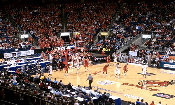
- Total Mortgage Arena – Sporting events venue, but also hosts large concerts
- Hartford HealthCare Amphitheater - Outdoor concert venue
Music festivals and concert series
This section does not cite any sources. (September 2021) |
Bridgeport was the annual home to Gathering of the Vibes, a weekend-long arts, music and camping festival, until it ended in 2015.
The Greater Bridgeport Symphony, established in 1945, performs at Bridgeport's 1,400-seat Klein Memorial Auditorium. Gustav Meier directed the orchestra from 1972 to 2013.
Museums and zoos
- The Discovery Science Center and Planetarium emphasizes exhibits on science, with the state's only Challenger Center, affiliated with the national space program. Opened in 1962 and run by SHU as of 2020.[135]
- The Housatonic Museum of Art at Housatonic Community College has the largest collection of art of any two-year college in the nation. Founded in 1967 by collage art director Bob Chernow. Shows both western and non-western art from different eras, including sculptures.[136]
- The Barnum Museum celebrates the showman, circuses and Bridgeport history. Currently under renovation, a room is open to visitors every Thursday.
- The Beardsley Zoo, opened 1922, is the only such center in Connecticut, and is the state's largest zoo.[134][137]
The Greater Bridgeport metropolitan area is home to the Maritime Aquarium in Norwalk, 30 minutes from downtown Bridgeport.[138] One of the two aquariums in Connecticut, the aquarium focuses on Long Island Sound as well as creatures and convervation efforts from around the world.[139]
Historic districts
This section does not cite any sources. (September 2021) |
Bridgeport has five local historic districts, where exterior changes to structures are under the control of two Historic District Commissions:
- Black Rock Harbor Historic District
- Pembroke City Historic District
- Stratfield Historic District
- Barnum-Palliser Development Historic District
- Marina Park Historic District
- Downtown North Historic District
- Downtown South Historic District
- Remington City Historic Distrct
- Black Rock Gardens Historic Distrct
- Seaside Village Historic District
- AMFAB Art Building
Bridgeport was once home to a Little Asia along Wood Avenue in the West Side, established in 2012 by local business owners with a sign and a festival every year. By 2016 the name had fallen out of use, and the committee no longer exists. The area is still home to Asian restaurants.[140][141]
Sports

| Club | League | Venue | Established | Championships | Logo |
|---|---|---|---|---|---|
| Bridgeport Islanders | AHL, Ice hockey | Total Mortgage Arena | 2001 | 0 |
Total Mortgage Arena serves as the city's sports and hospitality center. Seating 10,000, the Arena serves as the home rink of the Bridgeport Islanders AHL hockey team, the farm team of the New York Islanders team of the National Hockey League.[142]
The arena is also the home of the Westchester Knicks of the NBA G League (the farm team for the NBA New York Knicks) for the 2021–22 season. Their home stadium, Westchester County Center in White Plains, NY is currently being used as a vaccination clinic.[143]
For college teams, Total Mortgage serves as the home venue for Sacred Heart University's men's hockey team and as the home court of Fairfield University's basketball team.
The Ballpark at Harbor Yard served as a minor-league baseball stadium from 1998 to 2017. It was built in 1998 to serve as the homefield of the Bridgeport Bluefish. From 2001 to 2003 it was the homefield for the Bridgeport Barrage, a Major League Lacrosse team. It is downtown on a former brownfield site. It is visually prominent to commuters on I-95 or on passing trains. On August 8, 2017, Mayor Joe Ganim announced that the Bluefish would be ending their 20-year stint at the ballpark at the end of the 2017 season. The ballpark was converted into an amphitheatre. The Bluefish played their final home game at the park on September 17, 2017, losing by a score of 9–2 to the Somerset Patriots.[144]
Kennedy Stadium serves as a community sports facility. In the late 1960s and early 1970s, it was the home of an Atlantic Coast Football League minor league football team, the Bridgeport Jets, a New York Jets farm team also known locally as the Hi-Ho Jets due to their sponsorship by the (Hi-Ho) D'Addario construction company.

Fairfield University is in the neighboring town of Fairfield, and many of the athletic teams play on campus. Only the men's and women's basketball teams play in Bridgeport.
Nutmeg Curling Club, one of two curling clubs in Connecticut, is in Bridgeport. It is the home club of the 2013 USA Mixed National Champions,[145] led by club members Derek Surka and Charissa Lin. The club is a member of the Grand National Curling Club Region.
Bridgeport native Jim O'Rourke was the first baseball player to earn a hit in National League history in 1876. The founder and original owner of the Brooklyn Dodgers, Charles Ebbets, married his second wife in Bridgeport in 1922, five years before his death.
Parks and recreation
Photos from Bridgeport's public Parks


The city has 1,300 acers of public space, with a pocket park in nearly every neighborhood.[146] Bridgeport's public park system led to its official nickname, "the Park City". The city's first public park was the westerly portion of McLevy Green, first set aside as a public square in 1806;[147] the Clinton Park Militia Grounds (1666) and Old Mill Green (1717) were set aside earlier as public commons by the towns of Fairfield and Stratford, respectively. Washington Park in 1850 was located in the center of East Bridgeport.[148] As the city rapidly grew in population, residents recognized the need for more public parks and by 1864, Barnum and other residents had donated approximately 44 acres (18 ha) to create Seaside Park, now increased by acquisition and landfill to 375 acres (152 ha).[149] In 1878, over 100 acres (40 ha) of land bordering the Pequonnock River was added as Beardsley Park.[150] Frederick Law Olmsted, who designed New York City's Central Park, designed both Seaside and Beardsley Parks.[151] Over time, more parks were added including 35-acre (14 ha) Beechwood Park and Pleasure Beach, home to an amusement park for many years. Went Field on the West End, between Wordin Avenue and Norman Street, used to be the winter headquarters of Barnum's circus.
Architecture
Notable buildings and architectural styles in Bridgeport
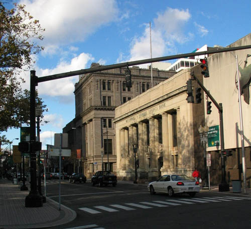
 Bridgeport Center - An 18-floor postmodern building designed by Richard Meier and built 1989. It is the tallest building in Bridgeport.
 Park City Plaza - an 18-story modernist style building completed in 1973.
 Hotel Beach, a 13-story Art Deco building built downtown in 1927 on Fairfield Avenue.
 Apartment house on Milne Street, in Sterling Hill, settled by the Irish. Three deckers, brick tenerments and small houses are found here.
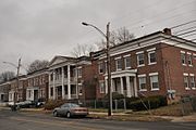 Remington City rowhouses on Bond Street. Built for workers during WW1, emulates European cottage styles.
 Queen Anne style tenements within the Barnum Palisser historic district in the South End, built by Barnum in the 1870s for working class families
 1850s Victorian residences around Washington Park on the East Side
 Golden Hill United Methodist Church in between Downtown and the Hollow near City Hall.
 CityTrust Bank building, finished 1929. Today a Citi Bank branch and apartments above.
 McLevy Hall, built 1854, 3 stories, the original Bridgeport City Hall and County Courthouse. Renamed after Mayor McLevy.


Bridgeport was largely bypassed by Fortune 500 companies moving to Fairfield County in the second half of the 20th century, due to the city's growing reputation for having a rough industrial character. Thus was also largely bypassed by the skyscraper construction boom of the 70s and 80s, resulting in fewer modern skyscrapers than otheir cities [152] The tallest building in Bridgeport is currently Richard Meier-designed the 16-story, 248-foot (76 m) Bridgeport Center, which was completed in 1989 and surpassed the 18-story Park City Plaza, which was completed in 1973.
Government


The city is governed by the mayor-council system. Twenty members of the city council are elected from districts. Each district elects two members. The mayor is elected at-large by the entire city
Bridgeport is notable for having had a socialist mayor for 24 years, Jasper McLevy, who served from 1933 to 1957.
Mayor Joseph P. Ganim was involved in a corruption scandal, as was Mayor Eddie Perez of Hartford in 2010.[153] In June 2006, Mayor John M. Fabrizi admitted that he had used cocaine while in office.[154]
Bridgeport is recognized for its polarizing political culture. The city's current mayor, Joseph P. Ganim, has served the city seven terms since first taking office in 1991. After being indicted on charges of corruption in 2003, Ganim served nine years in federal prison.[155] After his release in 2015, Ganim announced his mayoral campaign to serve a sixth term in office. His campaign ran on a theme of providing him with a "second-chance," as he was renowned for his work of escaping the city from bankruptcy and build its economy from a post-industrial standpoint.[156]
In a divisive primary election between him, the city's mayor at the time, Bill Finch, and University of Bridgeport professor and real estate developer, Mary-Jane Foster, Ganim was able to receive the endorsement of the politically volatile democratic town committee, paving the way to his victory for being reelected mayor at the end of year.[156]
| Voter registration and party enrollment as of October 29, 2019[157] | |||||
|---|---|---|---|---|---|
| Party | Active voters | Inactive voters | Total voters | Percentage | |
| Republican | 4,505 | 205 | 4,710 | 6.06% | |
| Democratic | 48,117 | 2,154 | 50,271 | 64.73% | |
| Unaffiliated | 20,922 | 1,136 | 22,058 | 28.40% | |
| Minor parties | 589 | 32 | 621 | 0.80% | |
| Total | 74,133 | 3,527 | 77,660 | 100% | |
Bridgeport votes Democratic at the presidential level. In 1972 Richard M. Nixon was the last Republican to win the city; since then Democrats have prevailed, often by comfortable margins, the lone exception being 1984 when Walter Mondale carried the city by just 76 votes (0.16 percent) over Ronald Reagan.
Bridgeport's Democratic Town Committee has the authority to nominate and endorse Democratic candidates running for local office, and they have the resources to outperform challenger slates that may compete with them. The chairman is former state representative and local restaurateur, Mario Testa.[158]
| Year | Democratic | Republican | Third Parties |
|---|---|---|---|
| 2020 | 79.44% 33,515 | 19.60% 8,269 | 0.96% 404 |
| 2016 | 80.98% 32,035 | 16.67% 6,596 | 2.35% 929 |
| 2012 | 85.75% 32,135 | 13.79% 5,168 | 0.46% 173 |
| 2008 | 83.52% 33,976 | 15.99% 6,507 | 4.89% 199 |
| 2004 | 70.66% 26,280 | 27.76% 10,326 | 1.57% 585 |
| 2000 | 72.68% 24,303 | 22.15% 7,406 | 5.18% 1,731 |
| 1996 | 69.16% 22,883 | 20.51% 6,785 | 10.33% 3,419 |
| 1992 | 53.20% 22,321 | 31.34% 13,149 | 15.46% 6,486 |
| 1988 | 57.50% 23,831 | 41.22% 17,084 | 1.27% 527 |
| 1984 | 49.75% 24,332 | 49.59% 24,256 | 0.66% 321 |
| 1980 | 51.24% 23,505 | 41.82% 19,185 | 6.94% 3,185 |
| 1976 | 55.37% 26,330 | 43.79% 20,824 | 0.83% 397 |
| 1972 | 43.67% 24,572 | 54.09% 30,436 | 2.25% 1,265 |
| 1968 | 53.27% 30,065 | 37.23% 21,014 | 9.50% 5,363 |
| 1964 | 69.90% 43,710 | 30.10% 18,818 | 0.00% 0 |
| 1960 | 61.14% 41,950 | 38.86% 26,667 | 0.00% 0 |
| 1956 | 38.57% 26,560 | 61.43% 42,308 | 0.00% 0 |
Education
Higher education
Bridgeport is home to the University of Bridgeport, Housatonic Community College, Paier College, St. Vincent's College, and the Yeshiva Gedola of Bridgeport. The Yeshiva Gedola is the home of the Bridgeport Community Kollel, a rabbinic fellowship program.[161] The University of Bridgeport's Ernest C. Trefz School of Business offers undergraduate and graduate programs.
Sacred Heart University is located in the neighboring suburb of Fairfield on the town line, with its campus extending into the North End of Bridgeport on Park Avenue. Many of its students live in the city's North End. It is the second largest Catholic University in New England (behind Boston Collage). [162] Sacred Heart has campuses in nearby Stamford, as well as Griswold, CT and Dingle, Ireland, as well as St. Vincent's College in Bridgeport. The University of Bridgeport has secondary campuses in Waterbury and Stamford. Paier College near the University of Bridgeport is the only Private Arts college in Connecticut. Founded in 1946 in West Haven and previously located in Hamden, the college recently relocated to Seaside Park in Bridgeport.[163][164]
The Greater Bridgeport Area (made up of the surrounding towns) is home to Fairfield University in neighboring Fairfield, and Western Connecticut State University in Danbury.
Public education
The city's public school system has 30 elementary schools, three comprehensive high schools, two alternative programs and an interdistrict vocational aquaculture school. The system has about 20,800 students, making the Bridgeport Public Schools the second largest school system in Connecticut after Hartford. It is ranked #158 out of the 164 Connecticut school districts.[165] The school system employs a professional staff of more than 1,700.
The city has started a large school renovation and construction program, with plans for new schools and modernization of existing buildings.
Public high schools
- Bassick High School established in 1929. Serves students residing south of Route 1, in the Black Rock, the Hollow, Downtown, West End and South End neighborhoods.
1181 Fairfield Ave, Bridgeport, CT. 06605
- Central High School (CHS) established in 1876. Current building built in 1964. Houses the Central Magnet program. Serves students from north of Route 1, including the North End, part of Brooklawn and St. Vincent neighborhoods.
1 Lincoln Blvd, Bridgeport, CT. 06606
- Warren Harding High School Home to the International Baccalaureate Program (IBO) and the Health Magnet Program in association with Bridgeport Hospital, St. Vincent's Medical Center, and Bridgeport Manor; also the alma mater of Walt Kelly, creator of Pogo. Serves East End, East Side, Mill Hill and North Bridgeport students.
379 Bond St, Bridgeport, CT. 06610
- Bridgeport Regional Vocational Aquaculture School (BRVAS), a half-day school specializing in marine and aquaculture curricula near Captain's Cove and open to students from surrounding towns. Serves all Bridgeport applicants and applicants from neighboring towns' (Trumbull, Stratford, Fairfield, Milford, Shelton, Monroe, and Region 9) school districts.
60 St. Stephens Rd, Bridgeport, CT
Public magnet high schools
- Fairchild Wheeler Interdistrict Multi-Magnet High School, three specialIzard STEM high schools in one building. Those school being 3: IT and softwere technology school, Aerospace/Hydrospace school, and Biotechnology school. Serves all Bridgeport applicants and applicants from neighboring towns (Trumbull, Stratford, Fairfield, Milford, Shelton, Monroe, Region 9). Acceptance by public lottery.
840 Old Town Road, Bridgeport, CT. 06606
- Central Magnet (part of Central High School) is a public preparatory magnet school. Serves all Bridgeport applicants, must meet grade requirements to enter lottery.
1 Lincoln Blvd, Bridgeport, CT. 06606
Public military/trade high schools
- Bridgeport Military Academy (BMA), a school for students looking for a career in public safety. Partnerships with local fire, police, Homeland Security and other departments. Open to all Bridgeport applicants.
160 Iranistan Ave, Bridgeport, CT. 06604
- Bullard-Havens Technical High School, a vocational high school. (State School, not part of Bridgeport Public Schools).
Charter schools
- The Bridge Academy: Bridgeport Charter High School
- Achievement First Bridgeport Charter High School
- Great Oaks Charter School
- Park City Prep Charter School
Private education
Bridgeport is also home to private schools, including Bridgeport Hope School (K–8), Bridgeport International Academy (grades 9–12), Catholic Academies of Bridgeport (Pre-K–8), Kolbe Cathedral High School (9–12), St. Andrew Academy (Pre-K–8), and St. Ann Academy (Pre-K–8).
Media
Radio
- WCUM AM 1450; 1,000 watts (formerly WJBX-AM, and before that, WNAB-AM) Spanish Format station better known as Radio Cumbre.
- WICC-AM 600; 1,000 watts (daytime), 500 watts (nighttime) – WICC began broadcasting on November 21, 1926, when a previous radio station, WCWS, was given a new name, WICC. The last three letters standing for Industrial Capitol of Connecticut. The Bridgeport Broadcasting Company Inc. was the new station's owner. Back then, the station was powered at 500 watts. From 1951 to 1956 one of the station's radio hosts was Bob Crane, who later went on to play Col. Robert Hogan on the Hogan's Heroes television comedy series.[166] WICC's transmitter is on Pleasure Beach in Bridgeport on a peninsula extending into Long Island Sound.
- WEBE-FM 107.9; 50,000 watts. WEBE108 is Connecticut's Best Music Variety! The station is owned by Connoisseur Media. Licensed to Westport, CT with studios in Milford and WEBE's transmitter is located in Shelton. Besides a standard analog transmission, WEBE broadcasts over one HD Radio channel, and is available online.
- WEZN-FM 99.9; 27,500 watts (formerly WJZZ-FM). Star 99.9 is Today's Best Mix! The station is owned by Connoisseur Media. Lincensed to Bridgeport, CT with studios in Milford and WEZN's transmitter is located in Trumbull.
- WPKN-FM 89.5; 10,000 watts[167]
Newspapers
- Elsolnews.com, a community Spanish-language weekly newspaper covering news and events.
- Connecticut Post – Formerly the Bridgeport Post and Bridgeport Telegram, which covers Bridgeport and the surrounding area. The newspaper is printed daily.
Television
Bridgeport was NBC's pioneer UHF TV test site from December 29, 1949, to August 23, 1952;[168] the equipment from the "Operation Bridgeport" tests was later deployed commercially at KPTV in Portland, Oregon (1952–1957). While Bridgeport is primarily served by New York City or New Haven-Hartford stations, some local UHF broadcasters operate today:
- WEDW channel 49; one of the Connecticut Public Television stations, broadcasts from Bridgeport and can be seen in Hartford.
- In 2011, WTNH-TV opened a satellite studio in the offices of the Connecticut Post Downtown on State Street.
- WZME channel 43; a ShopHQ affiliate, currently channel sharing with WEDW and licensed to Bridgeport.
Cable:
- News 12 Connecticut, an Altice-only cable news channel for local news and weather in Greater Bridgeport.
Movies filmed in Bridgeport
A list of films shot or partially filmed in the city:[169]
- Officer Down (2012)
- A Dance for Grace (2010)
- Ironmen (2010)
- 3 Weeks to Daytona (2009)
- Accidental Mayor (2009)
- All Good Things (2009)
- Confessions of a Shopaholic (2009)
- Dear Beautiful (2009)
- The Godfather Musical Part III: Luca Brasi Sleeps with the Fishes (2009)
- House of Satisfaction (2009)
- Made for Each Other (2009)
- The Music of Erich Zann (2009/II)
- Old Dogs (2009/I)
- College Road Trip (2008)
- Indiana Jones and the Kingdom of the Crystal Skull (2008)
- Pistol Whipped (2008)
- Righteous Kill (2008)
- The Sisterhood of the Traveling Pants 2 (2008)
- What Just Happened (2008)
- Bobby Dogs (2007)
- Dear Beautiful (2007)
- Praying to Hendrix (2007)
- Die Hard with a Vengeance (1995)
- A Walk with Death (1993)
- Route One USA (1989)
- There's a Nightmare in My Closet (1987)
- Without a Trace (1983)
- The Case of the Cosmic Comic (1976)
- The Effect of Gamma Rays on Man-in-the-Moon Marigolds (1972)
- The Light that Failed (1916)
Television shows filmed in Bridgeport
- Kitchen Nightmares (Season 4, Episode 7, "Tavolini Restaurant", 2011)
- Brian Boitano Skating Spectacular (2010) (TV)
- Ghost Adventures:"Remington Arms Factory" (Episode 21, November 2009)
- WWE Raw (November 18, 2002; March 8, 2004; December 26, 2005; August 21, 2006; April 9, 2007; April 27, 2009; June 21, 2010, April 11, 2011, and September 17, 2012)
- WWE Smackdown, ECW, and NXT (May 7, 2002; March 4, 2003; August 2, 2005; December 9, 2008; November 24, 2009; November 2, 2010; and November 15, 2011)
- Oprah Winfrey Presents: Mitch Albom's For One More Day (2007)
- WWE Raw's 15th Anniversary Special (2007)
- Flip This House: "Burning Down the House" (2005)
- Extreme Makeover: Home Edition (2003 & 2007)
- Made in America (2003)
- U.S. Bounty Hunter (2003)
- Muggsy (1976)
- The Twentieth Century (1957, The Class of '58 episode)
- Johnny, We Hardly Knew Ye (TV Movie, 1977), bar scene of JFK campaigning with local workers filmed in the Ideal Bar on Barnum Avenue across from the former Singer Building
- Live PD (2016–2017)
- Family Guy 2010
- Sneaky Pete (2015–) Although shot in the state of New York, much of the show takes place in Bridgeport
Infrastructure
Transportation
Airports

Sikorsky Memorial Airport in neighboring Stratford was previously owned by the City of Bridgeport before closing a deal in 2016 that sold the land to Stratford. It once provided regional flights to major cities, but commercial operations at the airport were terminated in November 1999.
Roads

Bridgeport has several major roadways. Interstate 95 and the Route 8/Route 25 Connector meet in Downtown Bridgeport. I-95 runs east–west near the coast heading towards New York City to the southwest and Providence to the northeast. Routes 8 and 25 run north–south across the city, with the two routes splitting just north of the city. Route 8 continues towards Waterbury and Torrington and Route 25 continues towards the Danbury area. Both Routes 8 and 25 connect to the Merritt Parkway in the adjacent town of Trumbull.
Other major surface arteries are U.S. 1 (the Boston Post Road), which runs east–west north of Downtown, and Main Street, which runs north–south towards Trumbull center. The city also has several secondary state highways, namely, Route 127 (East Main Street), Route 130 (Connecticut Avenue, Stratford Avenue, Fairfield Avenue and Water Street), and the Huntington Turnpike.
Railroad and ferries

The Bridgeport Traction Company provided streetcar service in the region until 1937. The Housatonic Railroad carried passengers North through the Pequonnock and Housatonic Valleys prior to 1933.
The city is connected to nearby New York City by both Amtrak and Metro-North commuter trains, which serve Bridgeport's Metro-North station. Many residents commute to New York jobs on these trains, and the city to some extent is developing as an outpost of New York–based workers seeking cheaper rents and larger living spaces. Connecting service is also available to Waterbury via Metro-North, and New Haven via Amtrak and Metro-North. Shoreline East service links Old Saybrook and New London with New Haven, which extends to Bridgeport and Stamford during weekday rush hours only.
The Bridgeport & Port Jefferson Ferry service runs from Bridgeport across Long Island Sound to Port Jefferson, New York; the three vessels Grand Republic, P.T. Barnum, and Park City transport both automobiles and passengers.
Buses

The Greater Bridgeport Transit Authority (GBTA) provides bus service to Bridgeport and its immediate suburbs. Route 2 the Coastal Link goes west to Norwalk and east to the Connecticut Post Mall in Milford, from where Connecticut Transit can bring passengers to the New Haven Green. Greyhound and Peter Pan Bus Lines both offer intercity bus service to points throughout the Northeast and points beyond.
Emergency services
Fire department
The Bridgeport Fire Department provides fire protection and emergency medical services at the Basic life support level to the city of Bridgeport.
Police department
The Bridgeport Police Department is the primary law enforcement agency in Bridgeport, Fairfield County, Connecticut, United States. It is responsible for most law enforcement within the geographical boundaries of City of Bridgeport.
Emergency medical services
Emergency medical services are provided by American Medical Response at the paramedic level.
In popular culture

Novels set in Bridgeport include:
- "Bridgeport?" Said I." "Camolot", said he." - A Connecticut Yankee in King Arthur's Court.
- Bridgeport is the setting of Maureen Howard's novel Natural History, which includes scenes from the city's history and depicts historical figures such as P. T. Barnum.
- David Foster Wallace mentions Bridgeport in his novel Infinite Jest, calling it the "true lower intestine of North America".[170]
Taxes
Bridgeport has one of the highest property tax rates in Connecticut.[171] A 2017 Lincoln Institute of Land Policy and Minnesota Center of Fiscal Excellence study determined that Bridgeport had the second-highest property tax burden of any U.S. city (after Detroit), and the fourth-highest for commercial properties valued at more than $1 million (after Detroit, New York City, and Chicago).[172]
In 2016, Bridgeport enacted a 29% increase in the property tax rate, among the highest one-year property tax rate increases in recent U.S. history, in an effort to reduce the municipal deficit.[173] A citywide reassessment in 2015 determined that the value of taxable property in the city was $6 billion, a decline of $1 billion; the property tax increases, combined with property value decreases, have been a consistent political issue in the city.[173]
See also
- List of people from Bridgeport, Connecticut
- National Register of Historic Places listings in Bridgeport, Connecticut
- Seaside Village Historic District
- St. Andrew Church (Bridgeport, Connecticut)
References
- "U.S. Census website". United States Census Bureau. Retrieved November 4, 2014.
- "US Census Bureau QuickFacts: Connecticut; Bridgeport". Retrieved August 19, 2021.
- "All Zip Codes in Bridgeport CT". www.zip-codes.com. Retrieved July 21, 2019.
- "Annual Town and County Population for Connecticut". portal.ct.gov.
- Andrews, Evan. "10 Things You May Not Know About P.T. Barnum". HISTORY. Retrieved May 22, 2020.
- Chisholm, Hugh, ed. (1911). . Encyclopædia Britannica. Vol. 3 (11th ed.). Cambridge University Press. p. 532.
- De Land, Fred (December 1906). "Notes on the Development of Telephone Service". Popular Science Monthly. p. 498. Retrieved July 31, 2022 – via Google Books.
- "Dental Hygiene School in CT | University of Bridgeport".
- Only in Bridgeport, a History of the Park City: Lenne Grimaldi
- "First US Detachable Electric Plug – Today in History: November 8 - Connecticut History | a CTHumanities Project". November 8, 2020.
- "History Of Frisbies". Archived from the original on November 10, 2007. Retrieved November 28, 2007.
- Emily Ross, Angus Holland (2005). One hundred great businesses and the minds behind them. Sourcebooks, Inc. p. 388. ISBN 978-1-4022-0631-3.
- Magubane, Vukani (October 13, 1985). "If You're Thinking of Living in; Bridgeport". The New York Times.
- "History – SHU Discovery Science Center".
- "About the Museum".
- "Sacred Heart and University of Bridgeport".
- "About".
- "Stratfield Historic District – Local Historic District and Property Commissions in Connecticut". lhdct.org.
- "The Golden Hill Paugussett Tribe". bportlibrary.org.
- Waldo (1917a), pp. 14–16.
- "Bridgeport, Conn.". The Encyclopedia Americana. Vol. 4. New York: Encyclopedia Americana Corp. 1918. p. 527. Retrieved July 29, 2010.
- Orcutt (1886a), p. 609.
- Orcutt (1886a), pp. 470–474.
- Waldo (1917a), pp. 222–225.
- Orcutt (1886a), endpaper.
- Enacted October 1800.
- The Public Statute Laws of the State of Connecticut, Vol. I, Title XXVII: Boroughs, Ch. I. Hartford: Hudson & Goodwin for the General Assembly. 1808. pp. 106–111.
- "An Act for incorporating part of the Town of Stratford",[26] published in the Public Statute Laws of the State of Connecticut.[27]
- Orcutt (1886a), p. 588.
- Orcutt (1886a), p. 597.
- Baynes, T. S., ed. (1878). . Encyclopædia Britannica. Vol. 4 (9th ed.). New York: Charles Scribner's Sons. p. 284.
- "Littlle Liberia".
- Orcutt (1886a), p. 610.
- Orcutt (1886b), p. 695.
- "Our 180 Year History". The Houstonic RailRoad Company Inc. Retrieved January 21, 2016.
- Waldo (1917a), pp. 37–38.
- Passed May 1836
- Resolves and Private Laws of the State of Connecticut, from the Year 1789 to the Year 1836, Vol. I, Title XI: Cities. Hartford: John B. Eldredge for the General Assembly. 1837. pp. 354–368.
- "An Act Incorporating the City of Bridgeport",[37] published in the Resolves and Private Laws of the State of Connecticut.[38]
- Orcutt (1886b), p. 696.
- Orcutt (1886b), p. 698–699.
- "About". Naugatuck Railroad: Operated by the Railroad Museum of New England. Retrieved January 21, 2016.
- Orcutt (1886b), p. 703.
- "P. T. Barnum: An Entertaining Life - Connecticut History | a CTHumanities Project". July 5, 2021.
- "General William Henry Noble – Bridgeport History Center".
- "The Park City – Who Knew? - Connecticut History | a CTHumanities Project". June 19, 2016.
- "Welcome to the Connecticut Irish-American Heritage Trail".
- "National Historic Places Nomination" (PDF). Black Rock. 1978. p. 11. Retrieved July 28, 2010.
- "PJSTCC Spotlight: The First Sight of Home — the Bridgeport and Port Jefferson Steamboat Company | TBR News Media".
- Hogan, Edmund P. (1977). An American heritage: A book about the International Silver Company, p. 160. Taylor Publishing Company: Dallas, TX. Retrieved August 27, 2018.
- (May 21, 2016). "Holmes & Edwards Silver Company design catalogues and historical documentation". artdesigncafé. Retrieved August 27, 2018.
- "Hungarian Immigrant Lives in Connecticut, 1909-1922 – Connecticut Digital Newspaper Project".
- "How the Jewish Immigrants Came to New England". December 22, 2019.
- Kimes, Beverly Rae; Clark, Henry Austin Jr., eds. (1989). The Standard Catalogue of American Cars 1805–1942 (2nd ed.). Krause Publications. ISBN 978-0-87341-111-0.
- Strother, French (January 1916). "America, A New World Arsenal". The World's Work. Vol. XXXI. pp. 321–333. Retrieved August 4, 2009.
- "New Issues of la Sentinella Now Online! – Connecticut Digital Newspaper Project".
- "The Story of Connecticut's Italians".
- "Population 1900-1960".
- "East Side Bridgeport – A Cityscape Made by the Great War – Bridgeport History Center".
- Foner, Philip Sheldon (1982). History of the Labor Movement in the United States. Vol. VI. International Publishers Co. p. 196. ISBN 978-0-7178-0595-2.
- "Housing Factory Workers in World War I". December 19, 2015.
- Connecticut – Race and Hispanic Origin for Selected Large Cities and Other Places: Earliest Census to 1900 (PDF). United States Census Bureau. p. 1. Archived from the original (PDF) on June 24, 2008. Retrieved July 19, 2022.
- "The History of Lordship!".
- "Beardsley Park and Zoo – Bridgeport History Center".
- "Poli Palace, Majestic Theater and Savoy Hotel (1922)". November 25, 2014.
- "Poli Palace, Majestic Theater & Savoy Hotel, Bridgeport – Damned Connecticut".
- "Historic Aerospace Site: Igor I. Sikorsky Memorial Airport" (PDF). American Institute of Aeronautics and Astronautics – via vtol.org.
- "Bridgeport Elects a Socialist Mayor Again and Again and Again". August 28, 2019.
- "Not Just from the South: The Great Black Migration to New England". June 19, 2020.
- "Bridgeport Working: Voices from the 20th Century". Bridgeport Public Library. Retrieved July 28, 2010.
- 4.10 North End Neighborhood Profile (PDF). Government of Bridgeport. Retrieved July 19, 2022.
- "Pa'lante: The Young Lords in Bridgeport – Bridgeport History Center".
- Condon, Tom (June 24, 2019). "City Revival -- Did We Learn From the Urban Renewal Era?". CT Mirror.
- "Connecticut Digital Archive | Connect. Preserve. Share".
- "Life in Bridgeport's Downtown North". January 9, 2015.
- "Time & Temp sign a landmark for I-95 travelers". January 6, 2012.
- Wald, Matthew L. (September 5, 1982). "THE Workplace in Transition". The New York Times. US. Retrieved July 28, 2010.
- "The Legend of Pleasure Beach – Bridgeport History Center".
- Musante, Fred (February 1, 1998). "Teachers' Strike Stirs Bitter Memories". The New York Times. Retrieved April 26, 2010.
- "Bridgeport Authorities Begin Patrol ofStreets in Arson‐Wave Battle". The New York Times. November 17, 1978.
- Rierden, Andi (February 25, 1990). "Bridgeport is Fighting Its 'Dump City' Image". The New York Times. Retrieved August 1, 2010.
- Charles, Eleanor (November 7, 1993). "In the Region/Connecticut; Bridgeport Hopes a Dowdy Mall Can Spur Rebirth". The New York Times.
- Barmash, Isadore (August 9, 1981). "Bridgeport Looks to Shift in Stores". The New York Times.
- "Failed Banking Institutions in Connecticut".
- "Bridgeport Center (1989)". January 12, 2010.
- Judson, George (August 2, 1991). "U.S. Judge Blocks Bridgeport From Bankruptcy Court". The New York Times. Retrieved July 17, 2010.
The case attracted national attention as Bridgeport portrayed itself as a city abandoned by industry, left to bear alone the poverty and social problems of Fairfield County that its suburbs turned their backs on.
- "1995 Bridgeport casino players: Two went to jail and one to the White House".
- "March 19: A Fallen Star Gets a Second Chance". March 19, 2022.
- Prevost, Lisa (April 10, 2009). "Revival in Progress; Stay Tuned". The New York Times. Retrieved August 5, 2010.
- Cummings, Bill (August 31, 2009). "Bridgeport council approves development plan". News Times. Danbury. Retrieved August 5, 2010.
- "Plan Bridgeport: Master Plan of Conservation & Development - Bridgeport, CT".
- Torres, Keila (February 14, 2010). "Agencies partner for housing/medical complex in Bridgeport". News Times. Danbury. Retrieved August 5, 2010.
- "Bridgeport residents support Steelpointe apartment plan, but raise concerns about gentrification". December 21, 2021.
- "Derelict buildings torn down in downtown Bridgeport". September 9, 2019.
- Request for Development Proposals: Historic Restoration, McLevy Hall. Bid Number PEX073226 (PDF). Preservation Connecticut. June 2022. Retrieved July 19, 2022.
- "MGM gambles on Bridgeport with new casino plan". Connecticut Post. Retrieved September 23, 2017.
- "Expanding CT Casino Gaming: Will a Third Casino Open in Connecticut?".
- "New East End library opening in Bridgeport after several delays". April 2, 2022.
- Burr, Raymond F., Abraham Lincoln: Western Star Over Connecticut, Lithographics Inc., Canton, Connecticut (no year given), pages 1 and 15; book contents reprinted by permission of the Lincoln Herald, (Harrogate, Tennessee) Summer, Fall and Winter, 1983 and Spring and Summer, 1984
- Holzer, Harold, Lincoln at Cooper Union, (Simon & Schuster: New York), 2004 Chapter 8: "Unable to Escape This Toil," p. 201 ISBN 0-7432-2466-3
- Lucas, Fred (April 6, 2006). "Bush visits Bridgeport". News Times. Danbury. Retrieved July 30, 2010.
- "Martin Luther King in Bridgeport?". Bridgeport Public Library. Archived from the original on December 26, 2010. Retrieved July 30, 2010.
- "Firsts".
- "The Case for Gustave Whitehead".
- "Dental Hygiene School in CT | University of Bridgeport".
- "The History of Subway®".
- "Archived Document". Archived from the original on August 25, 2015. Retrieved July 28, 2015.
- "Archived Document" (PDF). Archived from the original (PDF) on April 17, 2015. Retrieved July 28, 2015.
- "NowData – NOAA Online Weather Data". National Oceanic and Atmospheric Administration. Retrieved June 2, 2021.
- "Station: Bridgeport Sikorsky Mem AP, CT". U.S. Climate Normals 2020: U.S. Monthly Climate Normals (1991-2020). National Oceanic and Atmospheric Administration. Retrieved June 2, 2021.
- "U.S. Decennial Census". Census.gov. Retrieved July 14, 2015.
- "Population Estimates". United States Census Bureau. Retrieved June 8, 2018.
- "U.S. Decennial Census". Census.gov. Retrieved February 10, 2022.
- "Kurds: Families That Fled Iraq Struggle with Mixed Feelings".
- Bridgeport, Connecticut (CT) profile: population, maps, real estate, averages, homes, statistics, relocation, travel, jobs, hospitals, schools, crime, moving, houses, news. City-data.com. Retrieved on July 15, 2013.
- "City".
- "'Humanitarian crisis' on island worries CT's Puerto Rican community". September 26, 2017.
- "Explore Census Data".
- "Mexican heritage in southwestern Connecticut". April 27, 2017.
- "Ancestry in Bridgeport, Connecticut". Statistical Atlas. Retrieved July 19, 2022.
- Belsito, Walter John Jr. (June 27, 2016). The Lived Experiece of Brazilian Immigrants in Connecticut and Crimmigration (Thesis). University of Connecticut. Retrieved July 19, 2022.
- "Brazilian Consulate To Open In Hartford Monday - HartfordInfo.org". www.hartfordinfo.org.
- "Back to Brazil". February 17, 2013.
- "CT's Cuban-American Population is Centered in Bridgeport, as Immigration to U.S. From Cuba Grows".
- "The History of the Largest Foreign-Born Population in the State". November 14, 2018.
- "The Demographic Statistical Atlas of the United States". Statistical Atlas.
- The 25 Most Unequal Cities In America. Business Insider (October 11, 2010). Retrieved on 2013-07-15.
- Zumbrun, Joshua (November 30, 2009). "America's Most Unequal Cities". Forbes.
- "Sikorsky to cut 1,400 jobs, close Bridgeport plant". June 3, 2015.
- Former Bridgeport hospital converted to elderly, low income housing – Connecticut Post. Ctpost.com (September 13, 2010). Retrieved on 2013-07-15.
- "M&T's job cut plan in acquisition riles mayor of Bridgeport, Conn. | Local News | buffalonews.com". buffalonews.com.
- "M&T Bank completes $8.3 billion acquisition of People's United | Vermont Business Magazine".
- "City of Bridgeport Comprehensive Annual Financial Report For the Fiscal Year July 1, 2019- June 30, 2020" (PDF). City of Bridegport. Retrieved September 19, 2021.
- Harris, Patricia; Lyon, David (February 6, 2008). "On a comeback: After some down times, city find itself on the verge of a renaissance". Boston Globe. Retrieved August 5, 2010.
- "'A new and vibrant future': Sacred Heart University to acquire Discovery Museum". November 17, 2020.
- "Robbin Zella, Director of the Housatonic Museum of Art Invited to the National Conservation Summit in Washington DC". Bridgeport: Housatonic Community College. May 14, 2007. Archived from the original on February 25, 2012. Retrieved July 19, 2022.
- "SHU Discovery Science Center – Find Your Way To Wonder". www.shudiscovery.org.
- "The Maritime Aquarium at Norwalk". Visit CT. June 8, 2006.
- "Mission and Heritage | Maritime Aquarium - Norwalk, CT". www.maritimeaquarium.org.
- "Bridgeport workers sow seeds of 'Little Asia'". April 30, 2012.
- "News Feed".
- "Sound Tigers rebrand as 'Bridgeport Islanders'". May 10, 2021.
- "Westchester Knicks will play home games in Bridgeport, CT, for 2021-22 season". www.postingandtoasting.com. October 11, 2021.
- "Official Site of the Bridgeport Bluefish: News". August 8, 2017. Archived from the original on August 8, 2017. Retrieved January 15, 2018.
- "News". Team USA. Retrieved April 22, 2016.
- "25 Things You Should Know About Bridgeport, Connecticut". Mental Floss. February 23, 2016.
- Waldo (1917a), p. 277.
- "Washington Park". Bridgeport History Center.
- Holtz, Jeff (August 18, 2002). "The View From/Bridgeport; Historic Seaside Park Recaptures Its Appeal". The New York Times. Retrieved August 1, 2010.
- Waldo (1917a), p. 280.
- F.L. & J.C. Olmsted (1884). Beardsley Park: Landscape Architects' Preliminary Report. Privately Printed (Boston). pp. 4–7.
- "ARCHITECTURE VIEW; A Short Skyscraper With a Tall Assignment". The New York Times. March 26, 1989. Retrieved August 2, 2022.
- Everton Bailey Jr. (June 18, 2010). "Hartford Mayor Eddie Perez convicted of corruption". Christian Science Monitor. Associated Press. Retrieved August 15, 2010.
Corruption investigations have brought down several prominent Connecticut politicians within the past decade.... Bridgeport Mayor Joseph Ganim was convicted of corruption in 2003, sentenced to nine years in prison and released to a halfway house in Hartford in January. Former Waterbury Mayor Philip Giordano is serving a 37-year prison sentence for sexually abusing two girls, crimes that came to light during a federal corruption investigation.
- Daly, Michael J. (June 15, 2008). "Fabrizi's story still intrigues". Connecticut Post. Retrieved August 15, 2010.
- Cowan, Alison Leigh (2003). "Federal Judge Sentences Former Mayor of Bridgeport to 9 Years in Corruption Case". The New York Times. ISSN 0362-4331. Retrieved February 28, 2020.
- Chambers, Stefanie (2015). "Connecticut: Economics, Politics & Policy in the Constitution State". The New England Journal of Political Science. 8 (2): 258.
- "Registration and Party Enrollment Statistics as of October 29, 2019" (PDF). Connecticut Secretary of State. Retrieved April 29, 2022.
- "The Plague Of Absentee Ballots, Reforming The Democratic Town Committee – Only In Bridgeport®". Retrieved February 20, 2020.
- "General Elections Statement of Vote 1922". CT.gov – Connecticut's Official State Website.
- "Election Night Reporting". CT Secretary of State. Archived from the original on April 28, 2016. Retrieved December 16, 2020.
- "Bridgeport Kollel". Retrieved April 22, 2016.
- "Sacred Heart University: #202 in National Universities". U.S. News & World Report.
- "Art & Design School in CT | History".
- "Campus Map and Directions | University of Bridgeport".
- Connecticut State Districts – CT School District Rankings. Schooldigger.com. Retrieved on July 15, 2013.
- "History" section of the WICC website accessed June 29, 2006
- WPKN web site "About" page Archived July 15, 2006, at the Wayback Machine accessed June 29, 2006
- Cuda, Amanda (December 31, 2007). "1908 world ended at your town's border". Connecticut Post (ctpost.com, Bridgeport, CT).
- "IMDb: Most Popular Titles With Location Matching "Bridgeport, Connecticut, USA"". IMDb. Retrieved April 22, 2016.
- Wallace, David Foster (1996). Infinite Jest: A Novel (First ed.). Boston. ISBN 9780316920049.
- Brian Lockhart, Bridgeport Council raises car tax, CTPost (December 13, 2017).
- Alexander Soule, Study: Bridgeport has second 2nd worst property taxes, The Hour (May 19, 2017).
- Kristin Hussey & Lisa W. Foderaro, In Bridgeport, Property Values Plummet, but Taxes Soar for Some, New York Times (October 11, 2016).
Further reading
- Bucki, Cecelia Bucki (2001). Bridgeport's Socialist New Deal, 1915–36. University of Illinois Press. ISBN 978-0-252-02687-4.
- Nolen, John (1916). Better City Planning For Bridgeport. Bridgeport: City Plan Commission.
- Orcutt, Samuel (1886a). A History of the Old Town of Stratford and City of Bridgeport Connecticut. Vol. I. Bridgeport: Fairfield County Historical Society.
- Orcutt, Samuel (1886b). A History of the Old Town of Stratford and City of Bridgeport Connecticut. Vol. II. Bridgeport: Fairfield County Historical Society.
- Waldo, George Curtis (1917a). History of Bridgeport and Vicinity. Vol. I. S. J. Clarke. ISBN 978-1-144-35927-8.
- Waldo, George Curtis (1917b). History of Bridgeport and Vicinity. Vol. II. S. J. Clarke. ISBN 978-1-144-35927-8.
- Witkowski, Mary K. (2002). Bridgeport at Work. Arcadia Publishing. ISBN 978-0-7385-1123-8.
External links
Wikimedia Commons has media related to Bridgeport, Connecticut.
Wikivoyage has a travel guide for Bridgeport, Connecticut.
Municipalities and communities of Fairfield County, Connecticut, United States | ||
|---|---|---|
County seat: Bridgeport | ||
| Cities |
|  |
| Towns | ||
| Borough | ||
| CDPs |
| |
| Other communities |
| |
| Ghost town | ||
| Indian reservation |
| |
| Footnotes | ‡This populated place also has portions in an adjacent county or counties | |
| ||
State of Connecticut | |
|---|---|
Hartford (capital) | |
| Topics |
|
| Society |
|
| Regions |
|
| Counties | |
| Cities | |
| All Towns |
|
| Places |
|
New England | |||||||
|---|---|---|---|---|---|---|---|
| Topics |
| ||||||
| States | |||||||
| Major cities |
| ||||||
| State capitals |
| ||||||
| Transportation |
| ||||||
| |||||||
Places adjacent to Bridgeport, Connecticut | ||||||||||||||||
|---|---|---|---|---|---|---|---|---|---|---|---|---|---|---|---|---|
| ||||||||||||||||
Articles relating to Bridgeport, Connecticut | |||||||||||||||||||||||||||
|---|---|---|---|---|---|---|---|---|---|---|---|---|---|---|---|---|---|---|---|---|---|---|---|---|---|---|---|
| |||||||||||||||||||||||||||

Authority control | |
|---|---|
| General | |
| National libraries | |
| Other | |
На других языках
[de] Bridgeport (Connecticut)
Bridgeport ist mit 148.654 Einwohnern (Volkszählung 2020, U.S. Census Bureau) die größte Stadt im US-Bundesstaat Connecticut und war bis 1960 Sitz der Verwaltung von Fairfield County. Das Stadtgebiet hat eine Größe von 50,2 km².- [en] Bridgeport, Connecticut
[es] Bridgeport
Bridgeport (pronunciación en inglés: /ˈbɹɪd͡ʒˌpɔɹt/) es la ciudad más poblada del estado estadounidense de Connecticut y la quinta mayor en Nueva Inglaterra. Situada en el condado de Fairfield, la ciudad tiene una población estimada de 148,654 habitantes y es el corazón del área de Greater Bridgeport, que está considerada parte del área de mercado de trabajo de la ciudad de Nueva York. Unos de los tres portes del estado, es la sede del río Pequonnock, está en la costa del Long Island Sound.[ru] Бриджпорт (Коннектикут)
Бриджпорт (англ. Bridgeport) — город-порт в США, в штате Коннектикут[1], на берегу пролива Лонг-Айленд. Население — 144,2 тыс. человек (2010). Крупнейший город штата, часть агломерации Большой Бриджпорт. Является значимым промышленным районом. Развиты военная промышленность, машиностроение, металлообработка, изготовление электронного оборудования.Текст в блоке "Читать" взят с сайта "Википедия" и доступен по лицензии Creative Commons Attribution-ShareAlike; в отдельных случаях могут действовать дополнительные условия.
Другой контент может иметь иную лицензию. Перед использованием материалов сайта WikiSort.org внимательно изучите правила лицензирования конкретных элементов наполнения сайта.
Другой контент может иметь иную лицензию. Перед использованием материалов сайта WikiSort.org внимательно изучите правила лицензирования конкретных элементов наполнения сайта.
2019-2026
WikiSort.org - проект по пересортировке и дополнению контента Википедии
WikiSort.org - проект по пересортировке и дополнению контента Википедии