world.wikisort.org - USA
The Oklahoma City metropolitan area is an urban region in the Southern United States. It is the largest metropolitan area in the state of Oklahoma and contains the state capital and principal city, Oklahoma City. It is often known as the Oklahoma City Metro (sometimes shortened to simply "the Metro"), Oklahoma City Metroplex, or Greater Oklahoma City in addition to the nicknames Oklahoma City itself is known for, such as OKC or 'the 405'.
Oklahoma City Metropolitan Area | |
|---|---|
Metropolitan area | |
| Greater Oklahoma City | |
 Skyline of Oklahoma City | |
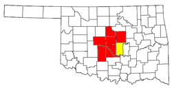 Highlighted in yellow indicates CSA. | |
| Coordinates: 35°30′N 97°30′W | |
| Country | United States |
| State(s) | Oklahoma |
| Principal Cities | Oklahoma City Shawnee (CSA) |
| Secondary Cities | Norman Edmond |
| Area | |
| • Total | 6,359 sq mi (16,470 km2) |
| Population (2020 Census) | |
| • Total | 1,425,695 |
| • Rank | 41st in the U.S. |
| • Density | 221.6/sq mi (85.3/km2) |
| • CSA Population | 1,498,693 |
| • CSA rank | 39th in the U.S. |
| Time zone | UTC−06:00 (CST) |
| • Summer (DST) | UTC−05:00 (CDT) |
| Area codes | 405, 572 |
| Interstates | |
The cities and towns within a radius of roughly 25 miles (40 km) from downtown Oklahoma City make up the Oklahoma City Metropolitan Area.[citation needed] Counties in the Oklahoma City Metropolitan Area include Canadian, Cleveland, Grady, Lincoln, Logan, McClain, and Oklahoma. According to the 2020 U.S. Census, the metropolitan region had a population of 1,425,695.
The micro urban area of Shawnee (in Pottawatomie County) is included in Oklahoma City's Combined Statistical Area (CSA) which brings the area population to 1,498,693. The Oklahoma City – Shawnee CSA is also included as part of the I-35 Megalopolis.
Political designations


- Principal Cities
- Oklahoma City
- Shawnee *CSA
- Secondary Cities
- Suburbs
- Exurbs
- Counties
Demographics
| Historical population | |||
|---|---|---|---|
| Census | Pop. | %± | |
| 1900 | 25,915 | — | |
| 1910 | 85,232 | 228.9% | |
| 1920 | 116,307 | 36.5% | |
| 1930 | 221,738 | 90.6% | |
| 1940 | 244,159 | 10.1% | |
| 1950 | 325,352 | 33.3% | |
| 1960 | 511,833 | 57.3% | |
| 1970 | 640,889 | 25.2% | |
| 1980 | 860,969 | 34.3% | |
| 1990 | 958,839 | 11.4% | |
| 2000 | 1,083,346 | 13.0% | |
| 2010 | 1,252,987 | 15.7% | |
| 2020 | 1,425,695 | 13.8% | |
| U.S. Decennial Census | |||
As of the 2010 Census, there were 1,252,987 people, 539,077 housing units, 489,654 households, and 320,335 families in Greater Oklahoma City. The metropolitan area's racial makeup was:
- 71.9% White (67.4% Non-Hispanic White)
- 10.4% Black
- 4.1% Native American
- 2.8% Asian
- 0.1% Pacific Islander
- 5.5% from other races
- 5.2% from two or more races
- 11.3% Hispanic or Latino of any race
As of 2016, the U.S. Census Bureau estimated the median household income in the MSA was $55,065, and the median family income was $68,797. The per capita income for the MSA in 2015 was $27,316. For the population age 25 years and over, 88.4% was a high school graduate for higher, and 29.8% had a Bachelor's degree or higher.
Metro-area
The following metro communities with populations of at least 1,000 found are considered suburbs and exurbs of Oklahoma City, generally within 25 miles (40 km) from downtown Oklahoma City or within the bounds of State Highway 33 to the north, State Highway 18 and US-177 to the east, State Highway 39 and State Highway 9 to the south, and US-81 to the west.
North of Oklahoma City
Edmond
Edmond is a suburb of around 90,000 people northeast of and adjacent to Oklahoma City.
Guthrie
Guthrie the first capital of the State of Oklahoma, lies to the north of Edmond in Logan County.
Nichols Hills
A separate city, surrounded by Oklahoma City and The Village, Nichols Hills, is just north of Belle Isle, and is an enclave of the affluent with many historic homes and parks.
The Village
The Village is another urban enclave that is entirely surrounded by Oklahoma City, except where it abuts Nichols Hills just to the south. Casady School, one of the largest and most well-known college preparatory schools in the Oklahoma City area, is located here.
Northeast of Oklahoma City
Chandler
Chandler is a city of about 3,000 located east of Edmond and north Oklahoma City on U.S. Route 66 and Interstate 44 and north of Shawnee on Highway 18 in Lincoln County.
Jones
Jones is a small community of around 3,000 a few miles south of I-44. Its location east of Edmond is isolated and hilly, but convenient to Oklahoma City at large.
East of Oklahoma City
Choctaw, Harrah, Nicoma Park, Spencer, and Meeker
Strung out along US-62 to the east of Oklahoma City are Choctaw, Harrah, Nicoma Park, Spencer, and Meeker.
Del City
Bordered by southeast Oklahoma City and adjacent to Tinker Air Force Base, Del City is home to about 22,000 residents.[1]
Midwest City
Midwest City is based largely around the sprawling Tinker Air Force Base.
Southeast of Oklahoma City
Shawnee
Shawnee, Oklahoma is an exurb of Oklahoma City, somewhat removed from the immediate metropolitan area by a 35-minute drive but is considered part of the Combined Statistical Area. The city of Shawnee has about 30,000 people and is home to two colleges: St. Gregory's University and Oklahoma Baptist University.
Bethel Acres, Tecumseh, McLoud, and Pink
These communities are exurbs of Oklahoma City and form a micropolitan area with Shawnee.
South of Oklahoma City
Valley Brook
Valley Brook is a small town of less than 1,000 nestled into Oklahoma City's south side. It is well known for stripteasedancing clubs and has somewhat relaxed laws for strip clubs compared to the rest of the metro, and several are prominently advertised on nearby I-35.
Moore
Moore is on I-35 between Oklahoma City and Norman. Moore's school district supports three high schools, Moore, Westmoore, and Southmoore.
Norman

Norman, Oklahoma is the anchor city of the south Oklahoma City Metropolitan Area. Norman is home to the University of Oklahoma, the state's largest university.
Noble, Purcell, Lexington, and Slaughterville
These four suburbs/exurbs lie south of Norman along the I-35 and US-77 corridors.
Noble is known as the "Rose-Rock Capital of the World" for its abundance of soil-bound barium sulfate.
Purcell, OK was founded as a railroad town in 1887, with the coming of the Atchison, Topeka and Santa Fe Railroad.
Goldsby and Washington
These small communities lie along I-35 just west of the South Canadian River. Goldsby is known for its Chickasaw Nation casinos: Goldsby Gaming Center, and Riverwind Casino, which is one of the largest casinos in Oklahoma.
Southwest of Oklahoma City
Newcastle, Tuttle, Blanchard, and Bridge Creek
Traveling along I-44 southwest from the City takes one into the fastest-growing part of the metro, which is known as "Tri-City" after its major constituents: Newcastle, Tuttle and Blanchard, Oklahoma. The area surrounds the tiny town of Bridge Creek. These suburbs have experienced rapid growth over the past 5–10 years as the result of people moving further from downtown Oklahoma City with an estimated combined population of 21,374 (2010 census). Though these communities have suffered growing pains, the increased residential and business development is improving the governments' abilities to improve the infrastructure needs and increase services. Newcastle serves as the epicenter of business development for the region but all of the communities are seeing growth in these arenas.
Bridge Creek suffered incredible damage from an F5 tornado during the Oklahoma tornado outbreak of May 3, 1999. Blanchard and Newcastle suffered damages in the tornado outbreak of May 24, 2011 with the loss or damages of over 350 homes and over 20 businesses, however there were no deaths.
Chickasha
Chickasha, an exurb of Oklahoma City, is along I-44 southwest of the City. With over 16,000 people, Chickasha is home to the University of Science and Arts of Oklahoma, the state's only public liberal arts institution.
West of Oklahoma City
Bethany, Woodlawn Park and Warr Acres
Bethany and Warr Acres are in the suburban inner western part of the city and are largely surrounded by parts of Oklahoma City proper. These suburbs are home to the metro's most competitive tax rates, and have attracted numerous big box retailers. There are a large number of historic motels, restaurants, and bars along old Route 66 (now NW 39th St). Lake Overholser, the city's oldest lake, is surrounded by upscale housing and has recently seen proposals for resort development on its shores. There are growing Korean, East Indian, and Pakistani communities in this area.
Bethany is home to Southern Nazarene University and Southwestern Christian University and has a small, well-preserved main street area along 39th Street near the SNU campus. Unique compared to other suburbs, these suburban "enclaves" have a stagnant population.
Woodlawn Park is an independent enclave within Bethany consisting of 0.1 square miles (0.26 km2) with a population of 161 at the 2000 census.
Mustang
The eastern Mustang city limits are cut off from the rest of the metro by Will Rogers World Airport, which makes Mustang one of the most remote areas in the metro. Mustang Schools service a large area outside Mustang limits into Oklahoma City, which surrounds Mustang completely. The city of about 21,000 is rapidly growing.
Yukon and El Reno
Yukon, the home of Garth Brooks and Cross Canadian Ragweed, is a growing suburb located 13 miles (21 km) west of downtown on I-40 and the recently completed West Loop of the Kilpatrick Turnpike. The city is in the midst of a population and retail boom.
El Reno, named after Fort Reno which once stood there, is an active Main Street community. The Oklahoma Main Street Program is a downtown revitalization program. Once a Certified City, El Reno has transitioned to a Century Community. Also notable in El Reno is the trolley that runs through the downtown area.
Minco and Union City
These small, rural communities are located south of I-40 along US-81 in Grady and Canadian Counties, respectively, between El Reno and Chickasha.
Northwest of Oklahoma City
Piedmont
Piedmont is the fastest-growing city in the metro. As of 2016, the city had a population of around 7,400. It is just a few miles north of the intersection of State Highway 3 and State Highway 4 (at the north end of the latter), north of Yukon.
Cashion and Okarche
The towns of Cashion and Okarche are on the northwestern fringes of the metro area. Both towns lie in two counties: Cashion (Kingfisher and Logan) and Okarche (Kingfisher and Canadian). Cashion and Okarche are primarily in Kingfisher County, which is a rural county. The Logan County portion of Cashion and the Canadian County portion of Okarche, however, do lie within the defined boundaries of the Oklahoma City MSA.[2]
Towns with fewer than 1,000 people
There are many towns in the Oklahoma City MSA with less than 1,000 population.
- Arcadia
- Calumet
- Cedar Valley
- Cimarron City
- Fallis
- Forest Park
- Lake Aluma
- Luther
- Newalla
- Smith Village
- Warwick
- Wayne
- Wellston
- Woodlawn Park
In 2005, Hall Park was annexed by Norman and ceased to be a town, becoming instead a group of housing subdivisions.
Transportation
Major airports
- Will Rogers World Airport (passenger and cargo)
- Tinker Air Force Base (military)
- University of Oklahoma Westheimer Airport (general, university)
- Wiley Post Airport (general)
Major highways
 SH-3 Oklahoma State Highway 3
 SH-4 Oklahoma State Highway 4
 SH-9 Oklahoma State Highway 9
 Interstate 35
 SH-37 Oklahoma State Highway 37
 Interstate 40
 Interstate 44
 U.S. Route 62
 U.S. Route 66
 SH-74 Oklahoma State Highway 74
 U.S. Route 77
 SH-152 Oklahoma State Highway 152
 Interstate 235
 Interstate 240
 U.S. Route 277
- H.E. Bailey Spur
- John Kilpatrick Turnpike
Mass transit
- Citylink Edmond, local Edmond and Commuter Bus to downtown Oklahoma City
- Heritage Express Trolley, connects Heritage Park with downtown El Reno
- EMBARK, state's largest transit agency; bus and trolley service throughout Oklahoma County and, as of August 2019, for Norman[3]
- Oklahoma City Streetcar, tram service within the city of Oklahoma City (primarily downtown)
- Oklahoma City Regional Transit District, planned Commuter Rail and expanded metropolitan bus service
Campus mass transportation
- CART, local Norman area bus service and Express Bus to downtown Oklahoma City. Now strictly a campus service for the University of Oklahoma as of August 2019 and known as Campus Area Rapid Transit.[4]
References
 Travel information from Wikivoyage
 Data from Wikidata
- "Annual Estimates of the Resident Population for Incorporated Places: April 1, 2010 to July 1, 2015". United States Census Bureau. Archived from the original on February 13, 2020. Retrieved March 1, 2017.
- "Update of Statistical Area Definitions and Guidance on Their Uses" (PDF). Office of Management and Budget. December 6, 2009. Retrieved May 31, 2010.
- "EMBARK Norman". embarkok.com. Central Oklahoma Transportation and Parking Authority. Retrieved February 7, 2021.
- "Campus Area Rapid Transit". Campus Area Rapid Transit. University of Oklahoma. Retrieved February 7, 2021.
| Authority control |
|
|---|
Другой контент может иметь иную лицензию. Перед использованием материалов сайта WikiSort.org внимательно изучите правила лицензирования конкретных элементов наполнения сайта.
WikiSort.org - проект по пересортировке и дополнению контента Википедии