world.wikisort.org - USA
The Buffalo–Niagara Falls Metropolitan Statistical Area is a metropolitan area, designated by the United States Census Bureau, encompassing two counties — Erie and Niagara in Western New York. It has a population of almost 1.2 million people. It is the second-largest metropolitan area in the state of New York, centering on the urbanized area of Buffalo.
Buffalo – Niagara Falls Metropolitan Area | |
|---|---|
Metropolitan statistical area | |
| Buffalo–Niagara Falls Metropolitan Statistical Area | |
 | |
| Coordinates: 42°54′N 78°51′W | |
| Country | United States |
| State(s) | New York |
| Largest city | Buffalo |
| Other cities | - Niagara Falls - Tonawanda - North Tonawanda - Lackawanna - Lockport - Olean |
| Area | |
| • Total | 1,567 sq mi (4,060 km2) |
| Population (2020)[1] | |
| • Total | |
| • Rank | 49th in the U.S. |
| • Density | 718/sq mi (277/km2) |
As of April 1, 2020, the metropolitan statistical area (MSA) had a population of 1,166,902; the combined statistical area (CSA), which adds Cattaraugus, had a population of 1,215,826 inhabitants. It is part of the Great Lakes Megalopolis, which contains an estimated 54 million people. The larger Buffalo Niagara Region is an economic zone consisting of eight counties in Western New York.
In 2010, the Buffalo – Niagara Falls metropolitan statistical area was ranked the 10th best place in the U.S. for working mothers by ForbesWoman magazine.[2]
Counties
- Erie
- Niagara
- Cattaraugus (part of CSA)
Communities
Cities
- Buffalo
- Lackawanna
- Lockport
- Niagara Falls
- North Tonawanda
- Olean (part of CSA)
- Salamanca (part of CSA)
- Tonawanda
Towns
|
Villages
Census-designated places
Indian Reservations
- Cattaraugus Reservation (partial)
- Tonawanda Reservation (Erie County)
- Tonawanda Reservation (Niagara County)
- Tuscarora Reservation (Niagara County)
Demographics
| Historical population | |||
|---|---|---|---|
| Census | Pop. | %± | |
| 1940 | 959,487 | — | |
| 1950 | 1,089,230 | 13.5% | |
| 1960 | 1,306,957 | 20.0% | |
| 1970 | 1,349,211 | 3.2% | |
| 1980 | 1,242,826 | −7.9% | |
| 1990 | 1,189,340 | −4.3% | |
| 2000 | 1,170,111 | −1.6% | |
| 2010 | 1,135,509 | −3.0% | |
| 2020 | 1,166,902 | 2.8% | |
| Historical Population Figures[3] | |||
As of the 2020 Census[4] there were 1,166,902 people residing in the MSA. It was 74.5% White, 13.0% Black or African American, 0.7% American Indian or Alaska Native, 4.2% Asian, <0.1% Pacific Islander, 2.1% Other and 5.5% Two or More Races. 5.8% of the population identified as Hispanic or Latino.
Transportation
Amtrak stations
| Station | Code | City | County | Lines served |
|---|---|---|---|---|
| Buffalo–Depew | BUF | Depew | Erie | Empire Service, Lake Shore Limited, Maple Leaf |
| Buffalo – Exchange Street | BFX | Buffalo | Erie | Empire Service, Maple Leaf |
| Niagara Falls | NFL | Niagara Falls | Niagara | Empire Service, Maple Leaf |
Major airports
| Airport | IATA code | ICAO code | County |
|---|---|---|---|
| Buffalo Niagara International Airport | BUF | KBUF | Erie |
| Niagara Falls International Airport | IAG | KIAG | Niagara |
Major highways
- Interstate 90
- Interstate 190
- Interstate 290
- Interstate 990
- U.S. Route 20
- U.S. Route 20A
- U.S. Route 62
- U.S. Route 219
- New York State Route 5
- New York State Route 18
- New York State Route 33
- New York State Route 104
- New York State Route 198
- New York State Route 400
Combined Statistical Area
The Buffalo–Cheektowaga–Cattaraugus Combined Statistical Area is made up of three counties in western New York. The statistical area includes one metropolitan area and one micropolitan area.[5][6] As of the 2010 Census, the CSA had a population of 1,215,826.[7]
- Metropolitan Statistical Areas (MSAs)
- Buffalo–Niagara Falls (Erie and Niagara counties)
- Micropolitan Statistical Areas (μSAs)
See also
- New York census statistical areas
- Buffalo Niagara Region
- Great Lakes region
References
- "2010 Census Data - 2010 Census". 2010.census.gov. Archived from the original on March 24, 2011.
- Casserly, Meghan (July 26, 2010). "Full List: America's Top 50 U.S. Cities For Working Mothers". Forbes.
- "Population Estimates". U.S. Bureau of Census and Real Estate Center at Texas A&M University. 2010. Archived from the original on December 2, 2010. Retrieved 2010-11-10.
- "Buffalo-Cheektowaga, NY Metro Area Demographics and Housing 2020 Decennial Census".
- "Buffalo-Cheektowaga, NY Combined Statistical Area" (PDF). census.gov. Retrieved April 25, 2020.
- "Combined Statistical Areas and Component Core Based Statistical Areas" (TXT). United States Census Bureau, Population Division. June 24, 2008. Retrieved July 27, 2008. [dead link]
- "US 2010 Census". Archived from the original on July 6, 2011.
| Principal city | 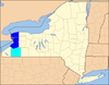 | |
|---|---|---|
| Other major cities |
| |
| Counties | ||
| Government and Services |
|  |
|---|---|---|
| Transportation |
| |
| Research and education |
| |
| Medicine and healthcare |
| |
| Other topics |
| |
| ||
State of New York | |
|---|---|
Albany (capital) | |
| Topics | |
| Politics |
|
| Regions |
|
| Metro areas |
|
| Counties |
|
| Places |
|
Great Lakes megalopolis as defined by the RPA | ||
|---|---|---|
Includes all metropolitan areas that have a population of 150,000 or greater according to the most recent national census. | ||
| Great Lakes region cities |
|  |
| Surrounding cities |
| |
| Cities of states south of region | ||
| Other metro-regions |
| |
Other megaregions | ||
Другой контент может иметь иную лицензию. Перед использованием материалов сайта WikiSort.org внимательно изучите правила лицензирования конкретных элементов наполнения сайта.
WikiSort.org - проект по пересортировке и дополнению контента Википедии