world.wikisort.org - USA
Ulster County is a county in the U.S. state of New York. It is situated along the Hudson River. As of the 2020 census, the population was 181,851.[2] The county seat is Kingston.[3] The county is named after the Irish province of Ulster.
Ulster County | |
|---|---|
County | |
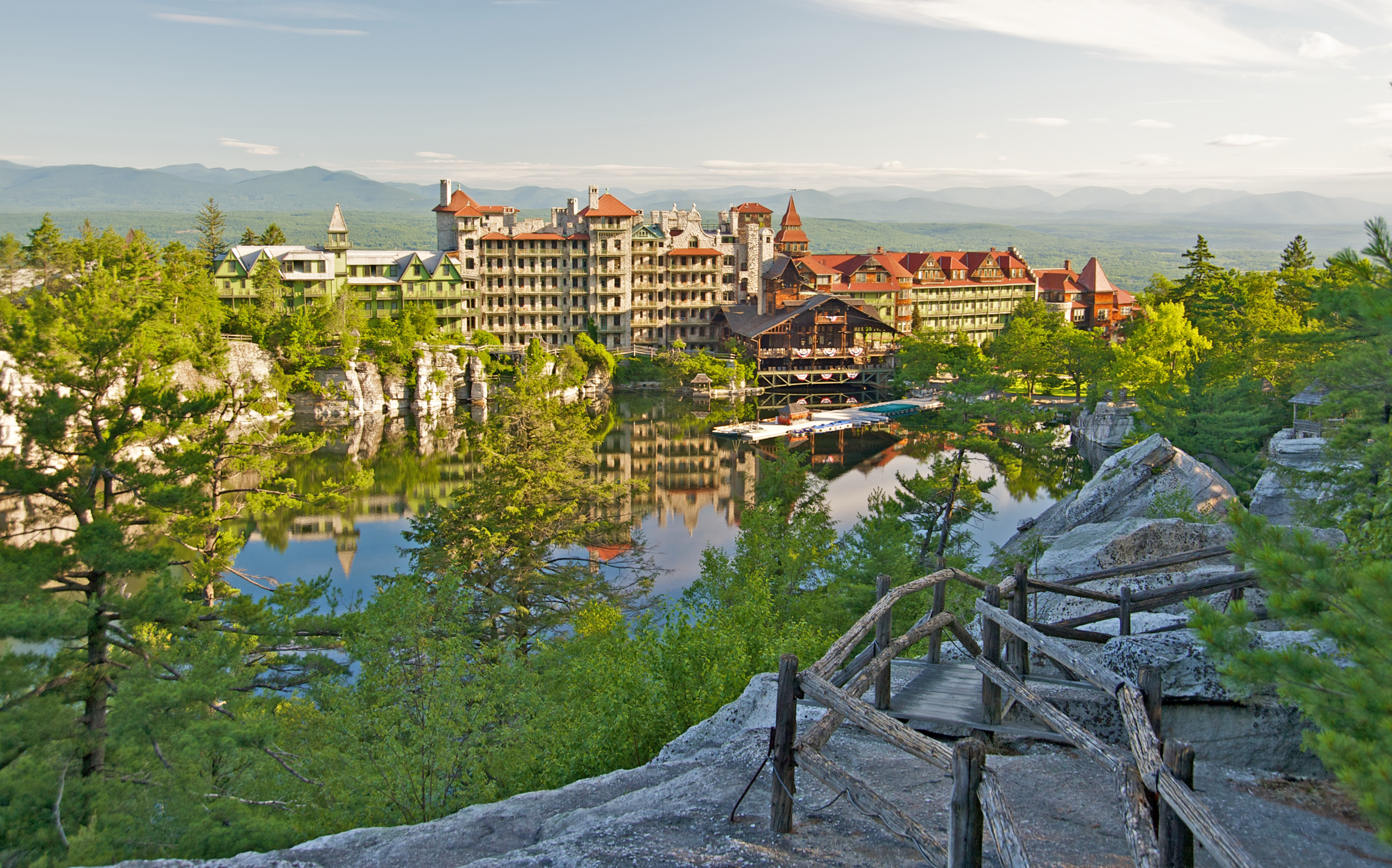 Mohonk Mountain House on Shawangunk Ridge | |
 Flag  Seal | |
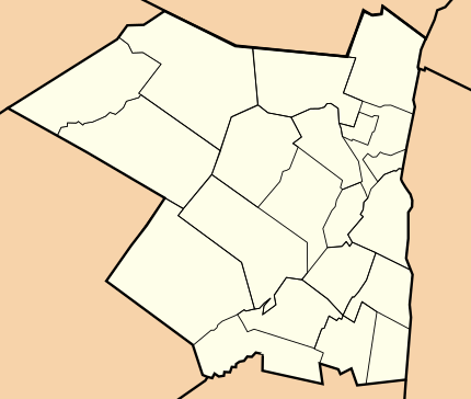
 Location within the U.S. state of New York | |
 New York's location within the U.S. | |
| Coordinates: 41°53′N 74°16′W | |
| Country | |
| State | |
| Founded | November 1, 1683[upper-alpha 1] |
| Named for | Ulster |
| Seat | Kingston |
| Largest city | Kingston |
| Government | |
| • County Executive | Johanna Contreras (Acting) (D) |
| Area | |
| • Total | 1,161 sq mi (3,010 km2) |
| • Land | 1,124 sq mi (2,910 km2) |
| • Water | 37 sq mi (100 km2) 3.1% |
| Population (2020) | |
| • Total | 181,851[1] |
| • Density | 161.8/sq mi (62.5/km2) |
| Time zone | UTC−5 (Eastern) |
| • Summer (DST) | UTC−4 (EDT) |
| Congressional district | 19th |
| Website | ulstercountyny |
History
This section needs additional citations for verification. (July 2016) |

Founding and formation
When part of the New Netherland colony, Dutch traders first called the area of present-day Ulster County "Esopus", a name borrowed for convenience from a locality on the opposite side of the Hudson. The local Lenape indigenous people called themselves Waranawanka, but soon came to be known to the Dutch as the "Esopus Indians" because they were encountered around the settlement known as Esopus. In 1652, Thomas Chambers, a freeholder from the Manor of Rensselaerswyck, purchased land at Esopus. He and several others actually settled and began farming by June, 1653. The settlements grew into the village of Wiltwijck, which the English later named Kingston. In 1683, the Duke of York created 12 counties in his province, one of which was Ulster County, named for Ulster, the northern part of Ireland, which had only recently been brought under English rule following a series of wars and rebellions, and then the Plantation of Ulster. Its boundaries at that time included the present Sullivan County and parts of the present Delaware, Orange, and Greene Counties.[upper-alpha 1]
In 1777, the first state capital of the independent New York State was established at Kingston. The official records of Ulster County were removed to safety to a stone house in Kerhonkson when it became evident that the British would burn Kingston.
In 1797, parts of Otsego and Ulster Counties were split off to create Delaware County.[upper-alpha 1]
In 1798, Ulster County's southernmost towns were moved into Orange County to compensate Orange for breaking away its southernmost part to form Rockland County.
In 1800, portions of Albany and Ulster Counties were split off to create Greene County.[upper-alpha 1]
In 1809, Sullivan County was split off from Ulster County.[upper-alpha 1]
Civil War
During the American Civil War, volunteers were recruited from the county and formed the majority of the following regiments:
- 80th New York Volunteer Infantry Regiment
- 120th New York Volunteer Infantry
- 156th New York Volunteer Infantry
Other regiments with at least one company from the county included:
- 1st Battalion New York Volunteer Sharpshooters
- 1st New York Volunteer Engineer Regiment
- 7th Regiment New York Volunteer Cavalry
- 7th New York Veteran Infantry Regiment
- 15th Regiment New York Volunteer Cavalry
- 20th New York Volunteer Infantry Regiment
- 25th Regiment New York Volunteer Cavalry
- 25th New York Volunteer Infantry Regiment
- 56th New York Volunteer Infantry
- 65th New York Volunteer Infantry
- 71st New York Infantry
- 102nd New York Volunteer Infantry
- 132nd New York Volunteer Infantry Regiment
- 168th New York Volunteer Infantry
- 176th New York Volunteer Infantry
- 178th New York Volunteer Infantry Regiment
- 192nd New York Volunteer Infantry
Twentieth century
The Lake Mohonk Mountain House on Shawangunk Ridge was designated a National Historic Landmark in 1986.[4]
Geography

According to the U.S. Census Bureau, the county has an area of 1,161 square miles (3,010 km2), of which 1,124 square miles (2,910 km2) is land and 37 square miles (96 km2) (3.1%) is water.[5]
Ulster County is in southeastern New York State, south of Albany, immediately west of the Hudson River. Much of it is within the Catskill Mountains and the Shawangunk Ridge. Ulster County has Minnewaska State Park Preserve, Mohonk Preserve, Sundown State Park, VerNooykill State Forest, Witches Hole State Forest, and Shawangunk Ridge State Forest. The Sam's Point section of Minnewaska includes rare dwarf pine trees and Verkeerder Kill falls.
The county's highest point is Slide Mountain, at approximately 4,180 feet (1,270 m) above sea level. The lowest point is sea level along the Hudson River.
Adjacent counties
- Greene County — north
- Columbia County — northeast
- Dutchess County — southeast
- Orange County — south
- Sullivan County — southwest
- Delaware County — northwest
National protected area
Demographics
| Historical population | |||
|---|---|---|---|
| Census | Pop. | %± | |
| 1790 | 29,370 | — | |
| 1800 | 24,855 | −15.4% | |
| 1810 | 26,576 | 6.9% | |
| 1820 | 30,934 | 16.4% | |
| 1830 | 36,550 | 18.2% | |
| 1840 | 45,822 | 25.4% | |
| 1850 | 59,384 | 29.6% | |
| 1860 | 76,381 | 28.6% | |
| 1870 | 84,075 | 10.1% | |
| 1880 | 85,838 | 2.1% | |
| 1890 | 87,062 | 1.4% | |
| 1900 | 88,422 | 1.6% | |
| 1910 | 91,769 | 3.8% | |
| 1920 | 74,979 | −18.3% | |
| 1930 | 80,155 | 6.9% | |
| 1940 | 87,017 | 8.6% | |
| 1950 | 92,621 | 6.4% | |
| 1960 | 118,804 | 28.3% | |
| 1970 | 141,241 | 18.9% | |
| 1980 | 158,158 | 12.0% | |
| 1990 | 165,304 | 4.5% | |
| 2000 | 177,749 | 7.5% | |
| 2010 | 182,493 | 2.7% | |
| 2020 | 181,851 | −0.4% | |
| U.S. Decennial Census[6] 1790-1960[7] 1900-1990[8] 1990-2000[9] 2010-2020[2] | |||
As of the census[10] of 2010, the county had 181,440 people, 67,499 households, and 43,536 families. The population density was 158 inhabitants per square mile (61/km2). There were 77,656 housing units at an average density of 69 per square mile (27/km2). The county's racial makeup, as of 2008, was 83.2% white, 6.50% black or African American, 0.3% Native American, 1.7% Asian, 0.03% Pacific Islander, 2.15% from other races, and 1.70% from two or more races. 7.6% of the population were Hispanic or Latino of any race. 19.2% were of Italian, 16.8% Irish, 15.5% German, 6.8% English, and 4.7% American ancestry according to Census 2000. 90.3% spoke English, 4.5% Spanish, 1.2% Italian, and 1.0% German as their first language.
There were 67,499 households, of which 30.70% had children under age 18 living with them, 49.20% were married couples living together, 10.90% had a female householder with no husband present, and 35.50% were non-families. Of all households, 27.90% were made up of individuals, and 10.20% had someone living alone who was 65 years of age or older. The average household size was 2.47 and the average family size was 3.03.
23.50% of the county's population was under age 18, 8.70% was from age 18 to 24, 29.70% was from age 25 to 44, 24.70% was from age 45 to 64, and 13.30% was age 65 or older. The median age was 38 years. For every 100 females, there were 99.10 males. For every 100 females age 18 and over, there were 96.60 males.
The county's median household income was $42,551, and the median family income was $51,708. Males had a median income of $36,808 versus $27,086 for females. The per capita income for the county was $20,846. About 7.20% of families and 11.40% of the population were below the poverty line, including 13.00% of those under age 18 and 8.70% of those age 65 or over.
2020 Census
| Race | Num. | Perc. |
|---|---|---|
| White (NH) | 136,695 | 75.16% |
| Black or African American (NH) | 10,152 | 5.8% |
| Native American (NH) | 306 | 0.2% |
| Asian (NH) | 3,778 | 2.1% |
| Pacific Islander (NH) | 45 | 0.02% |
| Other/Mixed (NH) | 9,756 | 5.4% |
| Hispanic or Latino | 21,119 | 11.61% |
Government and politics
| Year | Republican | Democratic | Third party | |||
|---|---|---|---|---|---|---|
| No. | % | No. | % | No. | % | |
| 2020 | 37,590 | 38.59% | 57,970 | 59.51% | 1,860 | 1.91% |
| 2016 | 35,239 | 41.32% | 44,597 | 52.29% | 5,454 | 6.39% |
| 2012 | 29,759 | 37.37% | 47,752 | 59.97% | 2,115 | 2.66% |
| 2008 | 33,300 | 37.35% | 54,320 | 60.93% | 1,529 | 1.72% |
| 2004 | 37,821 | 43.12% | 47,602 | 54.27% | 2,289 | 2.61% |
| 2000 | 33,447 | 42.75% | 38,162 | 48.78% | 6,628 | 8.47% |
| 1996 | 26,212 | 35.49% | 35,852 | 48.55% | 11,787 | 15.96% |
| 1992 | 29,223 | 36.16% | 32,886 | 40.69% | 18,712 | 23.15% |
| 1988 | 41,173 | 56.75% | 30,744 | 42.37% | 640 | 0.88% |
| 1984 | 47,372 | 63.93% | 26,445 | 35.69% | 285 | 0.38% |
| 1980 | 36,709 | 55.01% | 22,179 | 33.24% | 7,838 | 11.75% |
| 1976 | 35,353 | 53.44% | 30,190 | 45.64% | 610 | 0.92% |
| 1972 | 46,883 | 68.51% | 21,371 | 31.23% | 179 | 0.26% |
| 1968 | 34,798 | 57.62% | 20,886 | 34.59% | 4,703 | 7.79% |
| 1964 | 23,749 | 40.03% | 35,486 | 59.82% | 91 | 0.15% |
| 1960 | 36,418 | 61.20% | 23,017 | 38.68% | 67 | 0.11% |
| 1956 | 43,034 | 76.36% | 13,321 | 23.64% | 0 | 0.00% |
| 1952 | 36,141 | 69.44% | 15,733 | 30.23% | 171 | 0.33% |
| 1948 | 28,941 | 64.30% | 14,441 | 32.08% | 1,630 | 3.62% |
| 1944 | 26,703 | 61.02% | 16,943 | 38.72% | 117 | 0.27% |
| 1940 | 27,186 | 57.00% | 20,403 | 42.78% | 107 | 0.22% |
| 1936 | 24,678 | 55.32% | 19,118 | 42.85% | 815 | 1.83% |
| 1932 | 21,002 | 52.87% | 18,092 | 45.55% | 627 | 1.58% |
| 1928 | 25,418 | 62.46% | 14,200 | 34.89% | 1,077 | 2.65% |
| 1924 | 20,048 | 63.32% | 9,361 | 29.57% | 2,251 | 7.11% |
| 1920 | 19,001 | 66.41% | 8,759 | 30.61% | 852 | 2.98% |
| 1916 | 10,734 | 56.58% | 7,807 | 41.15% | 430 | 2.27% |
| 1912 | 7,485 | 38.33% | 8,510 | 43.58% | 3,531 | 18.08% |
| 1908 | 10,475 | 53.06% | 8,560 | 43.36% | 705 | 3.57% |
| 1904 | 11,356 | 53.13% | 9,516 | 44.52% | 501 | 2.34% |
| 1900 | 11,348 | 53.68% | 9,349 | 44.22% | 444 | 2.10% |
| 1896 | 11,100 | 56.31% | 8,140 | 41.30% | 471 | 2.39% |
| 1892 | 9,450 | 46.29% | 9,808 | 48.04% | 1,157 | 5.67% |
| 1888 | 10,825 | 49.57% | 10,487 | 48.02% | 526 | 2.41% |
| 1884 | 9,929 | 48.71% | 9,870 | 48.42% | 586 | 2.87% |
For most of the 20th century, Ulster County voted for the Republican nominees for president. Republicans regularly got over 60% of the vote, the high point coming when Dwight D. Eisenhower won 76% in 1956. The Democratic nominee won only in 1912, when Theodore Roosevelt and his Progressive Party split the Republican vote and gave a plurality to Woodrow Wilson, and in 1964, when Lyndon B. Johnson won every county in New York and carried Ulster County by 19.8 percentage points.
More recently, Ulster County has voted Democratic. In 1992, 1996, and 2000, the party won a plurality, due to strong showings from third parties. In 2004, John Kerry defeated George W. Bush, 54%–43%; in 2008, Barack Obama defeated John McCain, 61%–37%; in 2012, Obama defeated Mitt Romney, 60%–37%; in 2016, Hillary Clinton defeated Donald Trump, 52%–41%; and in 2020, Joe Biden defeated Trump, 60%–39%.
The county is in New York's 19th congressional district, along with other counties in the Catskills and Hudson Valley. It has had no U.S. representative since Antonio Delgado resigned on May 25, 2022, to become lieutenant governor of New York. Democrat Pat Ryan won a special election held on August 23, and was sworn in on September 13, 2022. On September 9, 2022, Ryan stepped down, and Johanna Contreras was sworn in as acting county executive.[13]
County government
For a long time, Ulster County had a county-scale version of a council-manager government, with the county legislature hiring a county administrator to handle executive functions. The chair of the legislature had a great deal of power and was accountable only to the voters of their district. The only countywide elected officials were the county clerk (Nina Postupack has served since 2006), district attorney (Dave Clegg took office in 2020) and sheriff (Juan Figueroa took office in 2019).
In 2006, voters approved the first-ever county charter, changing to an elected executive branch. Two years later, Michael P. Hein, the last appointed county administrator, became Ulster's first elected county executive.[14] In early 2019, Hein resigned to accept Governor Andrew Cuomo's appointment as commissioner of the state Office of Temporary and Disability Assistance.[15] Deputy County Executive Adele Reiter succeeded him as acting county executive until a special election was held in April 2019.
On April 30, 2019, Democrat Patrick K. Ryan was elected in a special election by a margin of 74%-26%.[16] He was sworn in as Ulster County's second County Executive on June 7, 2019.[17]
| Name | Party | Term |
|---|---|---|
| Michael P. Hein | Democratic | January 1, 2009 – February 11, 2019 |
| Adele Reiter | Democratic | February 11, 2019 – June 7, 2019 (Acting) |
| Pat Ryan | Democratic | June 7, 2019 – September 9, 2022 |
| Johanna Contreras | Democratic | September 9, 2022 – Present (Acting) |
Legislative authority is vested in the County Legislature, which consists of 23 members elected from individual districts, as directed by a county charter reapportionment mandate starting in late 2010.[18] Of the members of the County Legislature, 16 are part of the Democratic Caucus (15 affiliated with the Democratic Party and 1 unaffiliated), and 7 are part of the Republican Caucus (all 7 are affiliated with the Republican Party).
| District | Legislator | Party | Caucus | Residence |
|---|---|---|---|---|
| 1 | Aaron Levine | Democratic | Democratic | Saugerties |
| 2 | Joe Maloney | Democratic | Democratic | Saugerties |
| 3 | Dean Fabiano | Republican | Republican | Glasco |
| 4 | Brian Cahill | Democratic | Democratic | Ulster |
| 5 | Abe Uchitelle, Deputy Majority Leader | Democratic | Democratic | Kingston |
| 6 | Phil Erner | Democratic | Democratic | Kingston |
| 7 | Peter Criswell | Democratic | Democratic | Kingston |
| 8 | Laura Petit | Democratic | Democratic | Esopus |
| 9 | Herbert Litts III | Republican | Republican | Highland |
| 10 | Gina Hansut | Republican | Republican | Highland |
| 11 | Thomas Corcoran, Jr. | Republican | Republican | Marlborough |
| 12 | Kevin Roberts | Republican | Republican | Plattekill |
| 13 | Kenneth Ronk Jr., Minority Leader | Republican | Republican | Wallkill |
| 14 | Craig Lopez, Deputy Minority Leader | Republican | Republican | Pine Bush |
| 15 | John Gavaris | Democratic | Democratic | Ellenville |
| 16 | Tracey Bartels, Chair | Unaffiliated | Democratic | Gardiner |
| 17 | Megan Sperry | Democratic | Democratic | Rifton |
| 18 | Eric Stewart | Democratic | Democratic | Accord |
| 19 | Manna Jo Greene | Democratic | Democratic | Cottekill |
| 20 | Eve Walter, Vice Chair | Democratic | Democratic | New Paltz |
| 21 | Chris Hewitt | Democratic | Democratic | Kerhonkson |
| 22 | Kathy Nolan | Democratic | Democratic | Mount Tremper |
| 23 | Jonathan Heppner, Majority Leader | Democratic | Democratic | Woodstock |
Recreation


Ulster County contains a large part of Catskill Park and the Catskill Forest Preserve. The former Delaware and Hudson Canal brought Pennsylvania coal to Kingston on the Hudson. Former Orleans band member John Hall served in the Ulster County legislature before moving to the 19th Congressional District to run for Congress.
Ulster County has continued to be a popular vacation destination for many decades. The County is home to many outdoor landscapes, including the Catskill Mountains, the Hudson River, Minnewaska State Park, Catskill Park, Shawangunk Mountains and the Shawangunk Ridge. Each offers various recreation opportunities, including hiking, bicycling, skiing, horseback riding, kayaking, rock climbing, hunting and fishing.
The County also includes more than 40 miles (64 km) of rail trails along the Hudson Valley Rail Trail, Wallkill Valley Rail Trail, and O&W Rail Trail. The Walkway Over the Hudson, the world's longest pedestrian and bicycle bridge which spans the Hudson River, is connected within Ulster County trails.[19]
Ulster County has also played a role in some significant moments in U.S. history. The Senate House State Historic Site in Kingston, New York is where, in early 1777, American colonists met to ratify the New York Constitution.
The Ulster County Fair has been held in New Paltz for many years and is promoted as "The Best Six Days of Summer". County run recreation areas include the Ulster County Pool in New Paltz and the Ulster Landing Park in Saugerties.
Since 2016, Kingston Stockade FC, a semi-professional soccer team that plays in the National Premier Soccer League (NPSL), has been based in Kingston and plays its home matches at Dietz Stadium.[20]
Also since 2015, the Saugerties Stallions, a collegiate summer baseball league team that plays in the Perfect Game Collegiate Baseball League (PGCBL), have been based in Saugerties and play their home games at Cantine Field. The Stallions won the 2021 PGCBL Championship.[21]
Transportation

Public transportation in Ulster County is provided by Trailways of New York to and from New York City and Albany, and along Routes 28 and 32, by Ulster County Area Transit on major state and U.S. road corridors in the county, and by Kingston Citibus in Kingston.
Major Roadways
The New York State Thruway (I-87) runs north–south through the county, carrying traffic between New York City and Albany and its surroundings. NY 55, NY 52, and NY 28 are all major east-west highways that run through the county, and US 209, US 9W, and NY 32 are major north-south highways.

 I-87 / New York Thruway
 I-587
I-587 US 9W
US 9W US 44
US 44 US 209
 NY 28
NY 28 NY 28A
 NY 32
NY 32 NY 32A
 NY 42
NY 42 NY 52
NY 52 NY 55
NY 55 NY 55A
 NY 199
 NY 208
 NY 212
 NY 213
 NY 214
 NY 299
 NY 300
 NY 375
Communities
City
- Kingston (county seat)
Towns
Villages
Census-designated places
- Accord
- Clintondale
- Cragsmoor
- East Kingston
- Gardiner
- Glasco
- High Falls
- Highland
- Hillside
- Hurley
- Kerhonkson
- Lake Katrine
- Lincoln Park
- Malden-on-Hudson
- Marlboro
- Milton
- Napanoch
- Phoenicia
- Pine Hill
- Plattekill
- Port Ewen
- Rifton
- Rosendale
- Ruby
- Saugerties South
- Shokan
- Stone Ridge
- Tillson
- Walker Valley
- Wallkill
- Watchtower
- West Hurley
- Woodstock
- Zena
Hamlets
- Bearsville
- Big Indian
- Boiceville
- Brown's Station
- Centerville
- Chichester
- Cottekill
- Kaatsbaan
- Krumville
- Lew Beach
- Modena
- Mt. Pleasant
- Mt. Tremper
- Olivebridge
- Oliverea
- Palentown
- Samsonville
- Seager
- Shady
- Spring Glen
- Sundown
- Tabasco
- West Park
- West Saugerties
- West Shokan
- Willow
See also
- List of counties in New York
- National Register of Historic Places listings in Ulster County, New York
Notes
- "The county is one of the original divisions of the State, erected November 1, 1683. Of it's great territory it has given in the formation of Delaware in 1797, part of Greene in 1800, Sullivan in 1809, and a piece to Orange in the same year."[upper-alpha 2]
- Sullivan 1927, p. 437.
References
- "US Census 2020 Population Dataset Tables for New York". United States Census Bureau. Retrieved January 2, 2022.
- "U.S. Census Bureau QuickFacts: Ulster County, New York". United States Census Bureau. Retrieved January 2, 2022.
- "Find a County". National Association of Counties. Retrieved June 7, 2011.
- "National Historic Landmarks Program – Lake Mohonk Mountain House". National Park Service. Archived from the original on November 10, 2013. Retrieved December 7, 2013.
- "2010 Census Gazetteer Files". United States Census Bureau. August 22, 2012. Archived from the original on May 19, 2014. Retrieved January 8, 2015.
- "U.S. Decennial Census". United States Census Bureau. Retrieved January 8, 2015.
- "Historical Census Browser". University of Virginia Library. Retrieved January 8, 2015.
- "Population of Counties by Decennial Census: 1900 to 1990". United States Census Bureau. Retrieved January 8, 2015.
- "Census 2000 PHC-T-4. Ranking Tables for Counties: 1990 and 2000" (PDF). United States Census Bureau. Retrieved January 8, 2015.
- "U.S. Census website". United States Census Bureau. Retrieved January 31, 2008.
- "P2 HISPANIC OR LATINO, AND NOT HISPANIC OR LATINO BY RACE – 2020: DEC Redistricting Data (PL 94-171) – Ulster County, New York".
- Leip, David. "Dave Leip's Atlas of U.S. Presidential Elections". uselectionatlas.org.
- "Congressman-elect Pat Ryan resigns as Ulster County executive; Contreras sworn in". Daily Freeman. Retrieved September 10, 2022.
- Brooks, Paul (November 5, 2008). "Hein wins big as first Ulster County executive". Times-Herald Record. Ottaway Community Newspapers. Retrieved November 21, 2008.
- Doxsey, Patricia (January 4, 2019). "Ulster County Executive Michael Hein leaving to take state post". Daily Freeman. Retrieved February 28, 2020.
- Doxsey, Patricia (April 30, 2019). "Democrat Ryan coasts to victory in Ulster County executive special election". Daily Freeman. Retrieved February 28, 2020.
- Doxsey, Patricia (June 7, 2019). "Ryan sworn in as Ulster County executive, promises to lead with 'bold vision'". Daily Freeman. Retrieved February 28, 2020.
- Ulster reapportionment panel to revamp Legislature. DailyFreeman.com. Retrieved on August 9, 2013.
- "Ulster County Rails and Trails | Ulster County". ulstercountyny.gov. Retrieved February 8, 2022.
- "Kingston Stockade FC". Kingston Stockade FC. Retrieved February 8, 2022.
- "Saugerties Stallions Win 2021 PGCBL Championship Series". Perfect Game Collegiate Baseball League. August 3, 2021. Retrieved January 23, 2022.
- Bibliography
- Clearwater, Alphonso Trumpbour, ed. (1907). The History of Ulster County, New York. Kingston, NY: W. J. Van Deusen. LCCN 08017379.
- Fried, Marc B. (1975). The Early History of Kingston & Ulster County, NY. Marbletown, NY: Ulster County Historical Society.
- Sullivan, James; Williams, Melvin E.; Conklin, Edwin P.; Fitzpatrick, Benedict, eds. (1927). "Chapter IV. Ulster County.". History of New York State, 1523–1927 (PDF). Vol. 2. New York City, Chicago: Lewis Historical Publishing Co. pp. 437–43. hdl:2027/mdp.39015019994048. Wikidata Q114149636.
- Sylvester, Nathaniel Bartlett (1880). History of Ulster County, New York, with Illustrations and Biographical Sketches of its Prominent Men and Pioneers: Part Second: History of the Towns of Ulster County. Philadelphia, PA: Everts & Peck. OCLC 2385957.
- Ulster County Historians (1984). The History of Ulster County, With Emphasis upon the Last 100 Years, 1883–1983. Kingston, NY: Ulster County Historians. OCLC 11345209.
- Van Buren, Augustus H. (1923). A History of Ulster County Under the Dominion of the Dutch. Kingston, NY. OCLC 1131828.
- Zimm, Louise Hasbrouck (1946). Southeastern New York: A History of the Counties of Ulster, Dutchess, Orange, Rockland and Putnam. New York: Lewis Historical Publishing Co.
External links
- Ulster County web site
- Ulster County at Curlie
- Ulster County Alive
- Guide to the Ulster County Collection, 1666-1893
Places adjacent to Ulster County, New York | ||||||||||||||||
|---|---|---|---|---|---|---|---|---|---|---|---|---|---|---|---|---|
| ||||||||||||||||

| |||||||||
| |||||||||
Authority control | |
|---|---|
| General | |
| National libraries | |
| Other |
|
На других языках
[de] Ulster County
Ulster County[1] ist ein County im Bundesstaat New York der Vereinigten Staaten. Bei der Volkszählung im Jahr 2020 hatte das County 181.851 Einwohner und eine Bevölkerungsdichte von 62,5 Einwohnern pro Quadratkilometer.[2] Der Verwaltungssitz (County Seat) ist Kingston.- [en] Ulster County, New York
[ru] Алстер (округ)
Округ Алстер (англ. Ulster County) — округ штата Нью-Йорк, США. Население округа на 2000 год составляло 177694 человек. Административный центр округа — город Кингстон.Другой контент может иметь иную лицензию. Перед использованием материалов сайта WikiSort.org внимательно изучите правила лицензирования конкретных элементов наполнения сайта.
WikiSort.org - проект по пересортировке и дополнению контента Википедии