world.wikisort.org - USA
The Poughkeepsie–Newburgh–Middletown Metropolitan Statistical Area, as defined by the United States Census Bureau, is an area consisting of two counties in New York's Hudson Valley, with the cities of Poughkeepsie, Newburgh, and Middletown as its principal cities.[1] As of the 2020 census, the MSA had a population of 679,221 The area was centered on the urban area of Poughkeepsie-Newburgh.
Poughkeepsie–Newburgh–Middletown metropolitan area | |
|---|---|
Metropolitan statistical area | |
| Poughkeepsie–Newburgh–Middletown Metropolitan Statistical Area | |
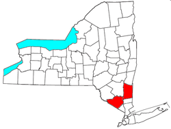 Location of the Poughkeepsie-Newburgh-Middletown Metropolitan Statistical Area in New York | |
| Country | United States |
| State | New York |
| Largest city | Poughkeepsie |
| Other cities | - Beacon - Middletown - Newburgh - Port Jervis |
| Area | |
| • Total | 1,664 sq mi (4,310 km2) |
| • Land | 1,608 sq mi (4,160 km2) |
| • Water | 57 sq mi (150 km2) |
| Population (2020) | |
| • Total | 679,221 |
| • Rank | 84th in the U.S. |
| • Density | 410/sq mi (160/km2) |
| Time zone | UTC-5 (EST) |
| • Summer (DST) | UTC-4 (EDT) |
| Area code(s) | 518, 838, 845 |
The Poughkeepsie-Newburgh-Middletown MSA is a component of the New York–Newark–Bridgeport, NY-NJ-CT-PA Combined Statistical Area, which had an estimated population of 23,582,649 as of the 2020 census.
In February 2013, the MSA was deleted, and the constituent counties became part of the New York-Newark-Jersey City, NY-NJ-PA Metropolitan Statistical Areas.[2] During this time, the counties were split into two metropolitan divisions: Orange County was a part of the New York-Jersey City-White Plains, NY-NJ Metropolitan Division, while Dutchess County was in the Dutchess County-Putnam County, NY Metropolitan Division.[3] The MSA was restored as a separate entity in September 2018.[4]
Counties
Communities
Cities
- Beacon
- Middletown (Principal city)
- Newburgh (Principal city)
- Port Jervis
- Poughkeepsie (Principal city)
Towns
- Amenia
- Beekman
- Blooming Grove
- Chester
- Clinton
- Cornwall
- Crawford
- Deerpark
- Dover
- East Fishkill
- Fishkill
- Goshen
- Greenville
- Hamptonburgh
- Highlands
- Hyde Park
- LaGrange
- Milan
- Minisink
- Monroe
- Montgomery
- Mount Hope
- New Windsor
- Newburgh
- North East
- Palm Tree
- Pawling
- Pine Plains
- Pleasant Valley
- Poughkeepsie
- Red Hook
- Rhinebeck
- Stanford
- Tuxedo
- Union Vale
- Wallkill
- Wappinger
- Warwick
- Washington
- Wawayanda
- Woodbury
Villages
Census-designated places
- Amenia
- Arlington
- Balmville
- Beaver Dam Lake
- Brinckerhoff
- Central Valley
- Crown Heights
- Dover Plains
- Fairview
- Firthcliffe
- Fort Montgomery
- Gardnertown
- Haviland
- Highland Mills
- Hillside Lake
- Hopewell Junction
- Mechanicstown
- Myers Corner
- New Windsor
- Orange Lake
- Pine Bush
- Pine Plains
- Pleasant Valley
- Red Oaks Mill
- Salisbury Mills
- Scotchtown
- Spackenkill
- Sparrow Bush
- Staatsburg
- Vails Gate
- West Point
Hamlet
- Amity
- Annandale-on-Hudson
- Arden
- Barrytown
- Bellvale
- Bullville
- Campbell Hall
- Chelsea
- Circleville
- Cuddebackville
- Howells
- Huguenot
- Linden Acres
- Little Britain
- Michigan Corners
- Mountain Lodge Park
- Mountainville
- New Hamburg
- New Hampton
- Pine Island
- Pleasant Plains
- Rhinecliff
- Salt Point
- Shekomeko
- Slate Hill
- Sugar Loaf
- Thompson Ridge
- Verbank
- Wassaic
- Westbrookville
Demographics
| Historical population | |||
|---|---|---|---|
| Census | Pop. | %± | |
| 1990 | 567,109 | — | |
| 2000 | 621,517 | 9.6% | |
| 2010 | 670,301 | 7.8% | |
| 2020 | 679,221 | 1.3% | |
2010 Census
As of the census of 2010, there were 670,301 people, 233,890 households, and 164,352 families residing within the MSA. The racial makeup of the MSA was 78.50% White, 10.10% African American, 0.40% Native American, 2.90% Asian, 0.03% Pacific Islander, 5.20% from other races, and 2.90%% from two or more races. Hispanic or Latino of any race were 14.7% of the population.
2000 Census
As of the census[5] of 2000, there were 621,517 people, 214,324 households, and 153,660 families residing within the MSA. The racial makeup of the MSA was 83.68% White, 8.64% African American, 0.29% Native American, 1.96% Asian, 0.03% Pacific Islander, 3.31% from other races, and 2.07% from two or more races. Hispanic or Latino of any race were 9.30% of the population.
The median income for a household in the MSA was $52,572, and the median income for a family was $61,805. Males had a median income of $43,970 versus $30,764 for females. The per capita income for the MSA was $22,769.
Colleges and universities
- Dutchess County
- Adelphi University's Hudson Valley Center in the City of Poughkeepsie
- Bard College in Annandale-on-Hudson
- Culinary Institute of America's main campus in Hyde Park
- Dutchess Community College in the Town of Poughkeepsie
- Marist College in the Town of Poughkeepsie
- Ridley-Lowell Business & Technical Institute in the City of Poughkeepsie
- Vassar College in the Town of Poughkeepsie
- Orange County
- Mount Saint Mary College in Newburgh
- Orange County Community College in Middletown with a satellite campus in Newburgh
- United States Military Academy in West Point
Transportation
Major infrastructure includes:
- Stewart International Airport, which has scheduled flights on Allegiant Air, American Eagle, Delta Connection, JetBlue Airways and Norwegian Air Shuttle.
- Amtrak, with a station at Poughkeepsie.
- Metro North's Hudson Line, a commuter rail line serving the eastern Hudson communities
- Metro North's Port Jervis Line, a commuter rail line serving Orange County and part of Rockland County
- Interstate 87, the eastern section of the New York State Thruway.
- Interstate 84, going from Pennsylvania to Massachusetts.
- Taconic State Parkway, going from Columbia County to Westchester County.
- Commercial bus companies serving Newburgh, and other cities along the Hudson River, ultimately having a destination in Albany or in New York City.
See also
- New York census statistical areas
References
- List of principal cities of Metropolitan Statistical Areas as of 2008
- "Transitioning to the New OMB 2013 Metropolitan Area Definitions" (PDF). Federal Housing Finance Agency. p. 25. Retrieved 13 February 2015.
- "OMB Bulletin No. 13-01" (PDF). Office of Management and Budget. Retrieved 9 July 2013.
- United States Office of Management and Budget (14 September 2018). "OMB Bulletin No. 18-04" (PDF). Retrieved 11 July 2019.
- "U.S. Census website". United States Census Bureau. Retrieved 2008-01-31.
External links
- Bureau of Labor Statistics - May 2008 Metropolitan and Nonmetropolitan Area Occupational Employment and Wage Estimates
Другой контент может иметь иную лицензию. Перед использованием материалов сайта WikiSort.org внимательно изучите правила лицензирования конкретных элементов наполнения сайта.
WikiSort.org - проект по пересортировке и дополнению контента Википедии