world.wikisort.org - USA
St. Cloud is a city in the U.S. state of Minnesota and the largest population center in the state's central region. The population was 68,881 at the 2020 census,[4] making it Minnesota's 12th-largest city. St. Cloud is the county seat of Stearns County[6] and was named after the city of Saint-Cloud, France (in Île-de-France, near Paris), which was named after the 6th-century French monk Clodoald.
St. Cloud | |
|---|---|
City | |
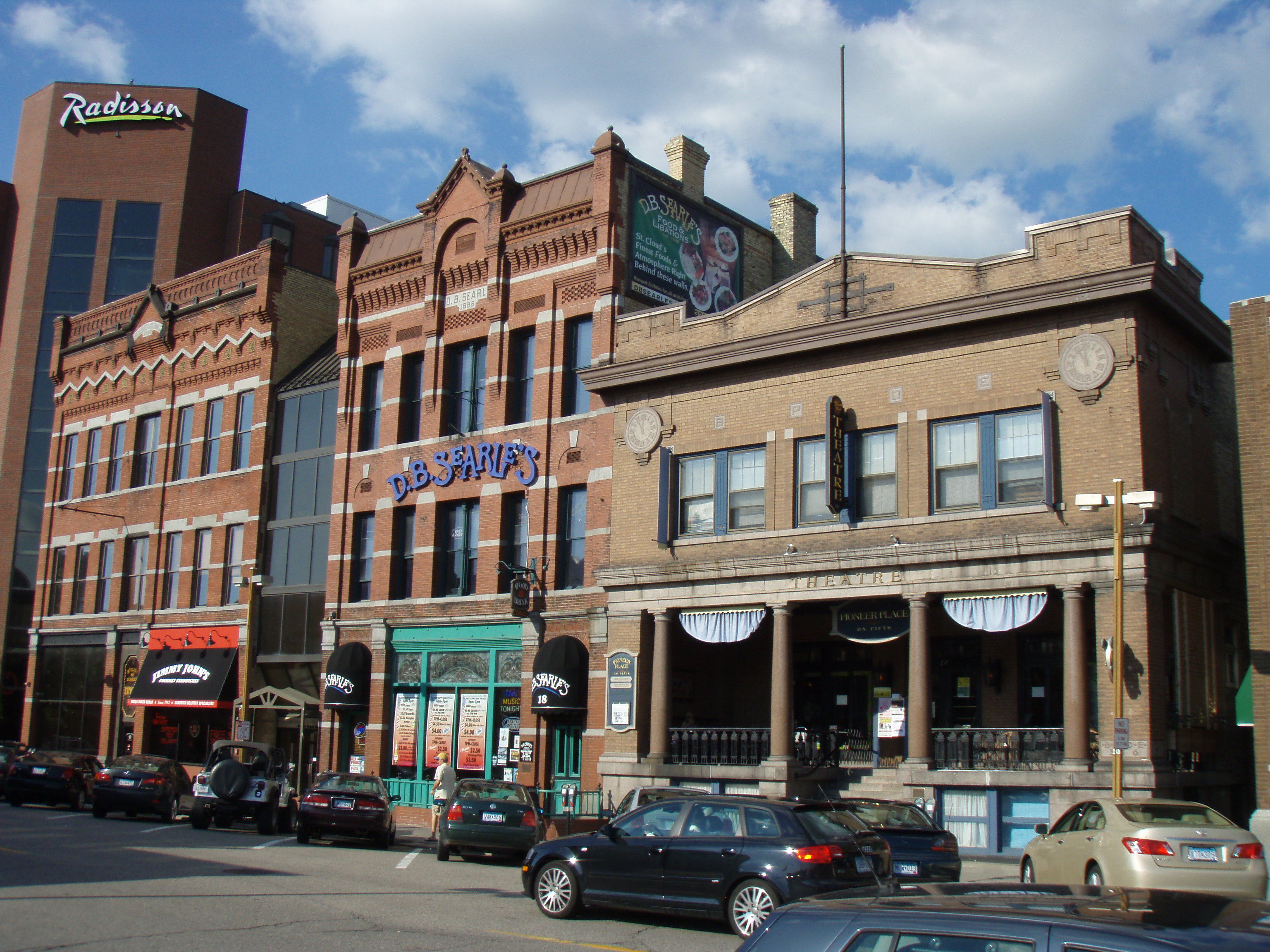 Buildings on 5th Avenue in downtown in 2008 | |
| Nickname: "The Granite City" | |
 Location within Stearns, Benton, and Sherburne Counties | |
 St. Cloud Location within Minnesota  St. Cloud Location within the United States | |
| Coordinates: 45°33′N 94°10′W | |
| Country | United States |
| State | Minnesota |
| Counties | Stearns, Benton, Sherburne |
| Founded | 1856[1] |
| Government | |
| • Mayor | Dave Kleis |
| Area | |
| • City | 41.23 sq mi (106.78 km2) |
| • Land | 40.17 sq mi (104.04 km2) |
| • Water | 1.06 sq mi (2.74 km2) |
| Elevation | 1,030 ft (314 m) |
| Population (2020)[4] | |
| • City | 68,881 |
| • Estimate (2021)[5] | 68,818 |
| • Rank | US: 548th MN: 12th |
| • Density | 1,714.78/sq mi (662.08/km2) |
| • Urban | 110,621 (US: 281st) |
| • Metro | 200,406 (US: 225th) |
| Time zone | UTC-6 (CST) |
| • Summer (DST) | UTC-5 (CDT) |
| ZIP codes | 56301, 56302, 56303, 56304, 56393, 56397, 56398 |
| Area code | 320 |
| FIPS code | 27-56896 |
| GNIS feature ID | 2396483[3] |
| Website | ci.stcloud.mn.us |

Though mostly in Stearns County, St. Cloud also extends into Benton and Sherburne counties, and straddles the Mississippi River. It is the center of a contiguous urban area, with Waite Park, Sauk Rapids, Sartell, St. Joseph, Rockville, and St. Augusta directly bordering the city, and Foley, Rice, Kimball, Clearwater, Clear Lake, and Cold Spring nearby. The St. Cloud metropolitan area had a population of 199,671 at the 2020 census. It has been listed as the fifth-largest metro with a presence in Minnesota, behind Minneapolis–St. Paul, Duluth–Superior, Fargo-Moorhead, and Rochester. But the entire St. Cloud area is entirely in Minnesota, while most of Fargo-Moorhead's population is in North Dakota and Superior, Wisconsin, contributes significant population to the Duluth area.
St. Cloud is 65 miles (105 km) northwest of the Twin Cities of Minneapolis–St. Paul along Interstate 94, U.S. Highway 52 (conjoined with I-94), U.S. Highway 10, Minnesota State Highway 15, and Minnesota State Highway 23. The St. Cloud Metropolitan Statistical Area (MSA) is made up of Stearns and Benton Counties.[7] The city was included in a newly defined Minneapolis–St. Paul–St. Cloud Combined Statistical Area (CSA) in 2000. St. Cloud as a whole has never been part of the 13-county MSA comprising Minneapolis, St. Paul, Bloomington and parts of western Wisconsin.[8]
St. Cloud State University, Minnesota's third-largest public university, is located between the downtown area and the Beaver Islands, which form a maze for a two-mile stretch of the Mississippi. The approximately 30 undeveloped islands are a popular destination for kayak and canoe enthusiasts[9] and are part of a state-designated 12-mile stretch of wild and scenic river.[10]
St. Cloud owns and operates a hydroelectric dam on the Mississippi, the state's largest city-owned hydro facility, that can produce almost nine megawatts of electricity, about 10% of the total electricity generated by 11 Mississippi hydro dams in Minnesota.[11][12][13]
History
What is now the St. Cloud area was occupied by various indigenous peoples for thousands of years. Europeans encountered the Ottawa, Ojibwe, and Winnebago when they started to trade with Native American peoples. [citation needed]
Minnesota was organized as a territory in 1849. The St. Cloud area was opened up to settlers in 1851[14] after treaty negotiations with the Winnebago (Ho-Chunk) tribe in 1851 and 1852. John Wilson, a Maine native with French Huguenot ancestry and an interest in Napoleon, named the settlement St. Cloud after Saint-Cloud, the Paris suburb where Napoleon had his favorite palace. [citation needed]
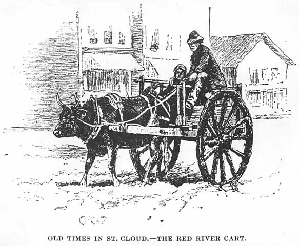
St. Cloud was a waystation on the Middle and Woods branches of the Red River Trails used by Métis traders between the Canada–US border at Pembina, North Dakota and St. Paul. The cart trains often consisted of hundreds of oxcarts. The Métis, bringing furs to trade for supplies to take back to their rural settlements, would camp west of the city and cross the Mississippi in St. Cloud or just to the north in Sauk Rapids
The City of St. Cloud was incorporated in 1856. It developed from three distinct settlements, known as Upper Town, Middle Town, and Lower Town, that were established by European-American settlers starting in 1853.[15] Remnants of the deep ravines that separated the three are still visible today. Middle Town was settled primarily by Catholic German immigrants and migrants from eastern states, who were recruited to the region by Father Francis Xavier Pierz, a Catholic priest who also ministered as a missionary to Native Americans.
Lower Town was founded by settlers from the Northern Tier of New England and the mid-Atlantic states, including former residents of upstate New York.[citation needed] Lower Town's Protestant settlers opposed slavery.[16]
Upper Town, or Arcadia, was plotted by General Sylvanus Lowry, a slaveholder and trader from Kentucky who brought slaves with him, although Minnesota was organized as a free territory.[17] He served on the territorial Council from 1852 to 1853 and was elected president of the newly formed town council in 1856, serving for one year (the office of mayor did not yet exist).[18][17][19]
Jane Grey Swisshelm, an abolitionist newspaper editor who had migrated from Pittsburgh, repeatedly attacked Lowry in print. At one point Lowry organized a "Committee of Vigilance" that broke into Swisshelm's newspaper office and removed her press, throwing it into the Mississippi River. Lowry started a rival paper, The Union.[19]
The US Supreme Court's 1857 decision in Dred Scott ruled that slaves could not file freedom suits and found the Missouri Compromise unconstitutional, so the territory's prohibition against slavery became unenforceable. Nearly all Southerners left the St. Cloud area when the Civil War broke out, taking their slaves with them.[19] Lowry died in the city in 1865.[20]
Beginning in 1864, Stephen Miller served a two-year term as Minnesota governor, the only citizen of St. Cloud ever to hold the office. Miller was a "Pennsylvania German businessman", lawyer, writer, active abolitionist, and personal friend of Alexander Ramsey. He was on the state's Republican electoral ticket with Abraham Lincoln in 1860.[21]
Steamboats regularly docked at St. Cloud as part of the fur trade and other commerce, although river levels were not reliable. This ended with the construction of the Coon Rapids Dam in 1912–14. Granite quarries have operated in the area since the 1880s, giving St. Cloud its nickname, "The Granite City."
In 1917, Samuel Pandolfo started the Pan Motor Company in St. Cloud. Pandolfo claimed his Pan-Cars would make St. Cloud the new Detroit but the company failed at a time when resources were directed toward the World War I effort. He was later convicted and imprisoned for attempting to defraud investors.[22][23]
Geography
According to the United States Census Bureau, the city has an area of 41.08 square miles (106.40 km2); 40.04 square miles (103.70 km2) is land and 1.04 square miles (2.69 km2) is water.[24]
The city is bisected by the Mississippi River, and part of the Sauk River runs along its northern edge.
Just south of downtown is the 7-acre, 35-feet-deep Lake George.[25] In 2021, the Minnesota Pollution Control Agency (MPCA) credited decade long-city investments in stormwater filtration with reducing Lake George's phosphorus levels well below the state standard. It called Lake George one of three "success stories" in the state, and planned to remove it from a list of impaired waters.[26]
Granite bedrock quarried in the area has been estimated to be 1.7 billion years old and was exposed after several miles of rock above it eroded. The city lies on a band of modern Mississippi river sediment surrounded by land scoured several times by Wisconsin Age glaciers beginning about 35,000 years ago, ending with the Lake Superior St. Croix lobe. The later Des Moines lobe created glacial moraines and drift south and east of the city.[27]
Climate
St. Cloud lies in the warm summer humid continental climate zone (Köppen climate classification: Dfb), with warm summers and cold winters with moderate to heavy snowfall. The monthly normal daily mean temperature ranges from 11.6 °F (−11.3 °C) in January to 70.3 °F (21.3 °C) in July. The record high temperature is 107 °F (42 °C). The record low temperature is -43 °F (-42 °C).[28]
| Climate data for St. Cloud Regional Airport, Minnesota (1991–2020 normals,[29] extremes 1894–present) | |||||||||||||
|---|---|---|---|---|---|---|---|---|---|---|---|---|---|
| Month | Jan | Feb | Mar | Apr | May | Jun | Jul | Aug | Sep | Oct | Nov | Dec | Year |
| Record high °F (°C) | 56 (13) |
59 (15) |
81 (27) |
96 (36) |
105 (41) |
102 (39) |
107 (42) |
105 (41) |
106 (41) |
90 (32) |
76 (24) |
63 (17) |
107 (42) |
| Mean maximum °F (°C) | 42 (6) |
45 (7) |
61 (16) |
78 (26) |
88 (31) |
92 (33) |
93 (34) |
91 (33) |
87 (31) |
79 (26) |
60 (16) |
44 (7) |
95 (35) |
| Average high °F (°C) | 20.7 (−6.3) |
25.7 (−3.5) |
38.5 (3.6) |
54.3 (12.4) |
67.8 (19.9) |
77.2 (25.1) |
81.6 (27.6) |
79.2 (26.2) |
71.0 (21.7) |
55.9 (13.3) |
39.3 (4.1) |
25.8 (−3.4) |
53.1 (11.7) |
| Daily mean °F (°C) | 11.8 (−11.2) |
16.1 (−8.8) |
29.2 (−1.6) |
43.3 (6.3) |
56.2 (13.4) |
66.0 (18.9) |
70.3 (21.3) |
67.7 (19.8) |
59.5 (15.3) |
45.7 (7.6) |
30.9 (−0.6) |
17.8 (−7.9) |
42.9 (6.1) |
| Average low °F (°C) | 2.9 (−16.2) |
6.5 (−14.2) |
19.8 (−6.8) |
32.4 (0.2) |
44.6 (7.0) |
54.8 (12.7) |
58.9 (14.9) |
56.3 (13.5) |
48.0 (8.9) |
35.5 (1.9) |
22.6 (−5.2) |
9.8 (−12.3) |
32.7 (0.4) |
| Mean minimum °F (°C) | −22 (−30) |
−16 (−27) |
−5 (−21) |
17 (−8) |
30 (−1) |
41 (5) |
47 (8) |
44 (7) |
31 (−1) |
20 (−7) |
3 (−16) |
−15 (−26) |
−25 (−32) |
| Record low °F (°C) | −43 (−42) |
−40 (−40) |
−32 (−36) |
−3 (−19) |
18 (−8) |
32 (0) |
40 (4) |
33 (1) |
18 (−8) |
5 (−15) |
−23 (−31) |
−41 (−41) |
−43 (−42) |
| Average precipitation inches (mm) | 0.67 (17) |
0.76 (19) |
1.57 (40) |
2.61 (66) |
3.66 (93) |
3.75 (95) |
3.60 (91) |
4.00 (102) |
3.01 (76) |
2.61 (66) |
1.37 (35) |
0.88 (22) |
28.49 (724) |
| Average snowfall inches (cm) | 8.8 (22) |
8.9 (23) |
8.2 (21) |
4.7 (12) |
0.1 (0.25) |
0.0 (0.0) |
0.0 (0.0) |
0.0 (0.0) |
0.0 (0.0) |
1.0 (2.5) |
6.9 (18) |
9.3 (24) |
47.9 (122) |
| Average precipitation days (≥ 0.01 in) | 7.8 | 6.4 | 8.3 | 9.7 | 11.4 | 12.3 | 10.6 | 9.3 | 10.0 | 9.7 | 7.3 | 7.7 | 110.5 |
| Average snowy days (≥ 0.1 in) | 8.5 | 6.4 | 5.0 | 2.2 | 0.2 | 0.0 | 0.0 | 0.0 | 0.0 | 0.9 | 4.6 | 8.2 | 36.0 |
| Source: NOAA[28][30] | |||||||||||||
Demographics
| Historical population | |||
|---|---|---|---|
| Census | Pop. | %± | |
| 1870 | 2,161 | — | |
| 1880 | 2,462 | 13.9% | |
| 1890 | 7,686 | 212.2% | |
| 1900 | 8,663 | 12.7% | |
| 1910 | 10,600 | 22.4% | |
| 1920 | 15,873 | 49.7% | |
| 1930 | 21,000 | 32.3% | |
| 1940 | 24,173 | 15.1% | |
| 1950 | 28,410 | 17.5% | |
| 1960 | 32,415 | 14.1% | |
| 1970 | 39,691 | 22.4% | |
| 1980 | 42,566 | 7.2% | |
| 1990 | 48,812 | 14.7% | |
| 2000 | 59,108 | 21.1% | |
| 2010 | 65,842 | 11.4% | |
| 2020 | 68,881 | 4.6% | |
| 2021 (est.) | 68,818 | [5] | −0.1% |
| U.S. Decennial Census[31] 2020 Census[4] | |||
2020 census
As of the census of 2020,[4][32] there were 68,881 people and 26,374 households residing in the city. The population density was 1,644.5 inhabitants per square mile (634.9/km2). The racial makeup of the city was 77.1% White, 14.6% African American, 0.6% Native American, 3.4% Asian, and 3.4% from two or more races. Hispanic or Latino of any race were 3.2% of the population.
St. Cloud is the principal city of the St. Cloud Metropolitan Statistical Area, a metropolitan area that covers Sherburne, Benton and Stearns counties and had a combined population of 199,671 at the 2020 census, an increase of 5.59% since 2010.
2010 census
As of the census of 2010, there were 65,842 people, 25,439 households, and 13,348 families residing in the city. The population density was 1,644.4 inhabitants per square mile (634.9/km2). There were 27,338 housing units at an average density of 682.8 per square mile (263.6/km2). The racial makeup of the city was 84.6% White, 7.8% African American, 0.7% Native American, 3.7% Asian, 0.8% from other races, and 2.5% from two or more races. Hispanic or Latino of any race were 2.4% of the population.
There were 25,439 households, of which 25.0% had children under the age of 18 living with them, 37.6% were married couples living together, 10.4% had a female householder with no husband present, 4.5% had a male householder with no wife present, and 47.5% were non-families. 30.8% of all households were made up of individuals, and 7.8% had someone living alone who was 65 years of age or older. The average household size was 2.37 and the average family size was 2.95.
The median age in the city was 28.8 years.[33] 18.9% of residents were under the age of 18; 23.9% were between the ages of 18 and 24; 25.5% were from 25 to 44; 21.5% were from 45 to 64; and 10.3% were 65 years of age or older. The gender makeup of the city was 51.5% male and 48.5% female.
2000 census
As of the census of 2000, 27.3% of St. Cloud households had children under the age of 18 living with them, 41.4% were married couples living together, 9.4% had a female householder with no husband present, and 45.9% were non-families. 30.2% of all households were made up of individuals, and 8.0% had someone living alone who was 65 years of age or older. The average household size was 2.40 and the average family size was 3.00.
The racial makeup of the city was 91.7% White, 2.4% African American, 0.7% Native American, 3.1% Asian, 0.7% other races, and 1.4% from two or more races. Hispanic or Latino of any race were 1.3% of the population.
Average income
According to the U.S. Bureau of Labor Statistics, as of May 2020 the annual mean wage for 99,600 employees across all occupations in St. Cloud was $50,800. The median hourly wage was $24.42.[34]
Top employers
According to St. Cloud's 2020 Comprehensive Annual Financial Report,[35] the top employers in the city are:
| # | Employer | # of Employees |
|---|---|---|
| 1 | *CentraCare Health System St. Cloud Hospital | 7,854 |
| 2 | State of Minnesota / St. Cloud State University | 2,259 |
| 3 | St. Cloud VA Medical Center | 1,767 |
| 4 | ** St. Cloud School District | 1,092 |
| 5 | Fullfillment Distribution Center | 784 |
| 6 | *** Stearns County | 732 |
| 7 | New Flyer of America Inc. | 677 |
| 8 | Capital One | 689 |
| 9 | Coborns Inc. | 673 |
| 10 | Anderson Trucking | 622 |
Arts, culture and events
In 2019 the city of Saint Cloud, Minnesota was awarded three first places awards from the Rome based International Awards for Liveable Communities (LivCom), one of several most livable cities awards. The city won the first-place whole city award for its size and first-place for cities of all sizes for Enhancement of landscapes and public spaces, Arts, culture and heritage management and Community participation and empowerment. The international organization praised the city for its focus on improving parkland and trails, as well as its enhancements and maintenace of 96 parks. The city has been a finalist at the LivCom awards four times since 2007.[36]
The St. Cloud Area Convention and Visitors Bureau promotes an area events calendar, dining and lodging information. The city-owned St. Cloud River's Edge Convention Center hosts a variety of events including regional conferences, consumer/trade shows, small group meetings and social events.
Sites of interest
- Cathedral of Saint Mary, the largest church serving the oldest parish in the community, built in the 1920s in the Italian Romanesque style. The cathedral is the mother church of the Roman Catholic Diocese of Saint Cloud.
- The St. Cloud Commercial Historic District is listed on the National Register of Historic Places. St. Cloud is a Preserve America Community.[37]
- St. Cloud State University.
- Great River Regional Library, a six-county regional system serving 32 communities. The system houses nearly 1 million books, CDs and DVDs and 250 public computers and schedules a list of events.
- Munsinger Gardens and Clemens Gardens, extensive flower gardens dating from the 1930s.
- Quarry Park and Nature Preserve, a public park that features 20 granite quarries, hiking, biking and ski trails. Part of the Stearns County park system.[38]
- Paramount Theatre and Visual Arts Center, a restored 706-seat theater, built in 1921.[39]
- St. Cloud Hospital, part of CentraCare Health, was founded in 1886 as St. Benedict's Hospital. The regional health system also includes six Critical Access hospitals, Rice Memorial Hospital in Willmar and numerous outreach and outpatient clinics and services.
- Stearns History Museum, with two floors of exhibits, a research area, a museum store, and a 100-acre (0.40 km2) nature park. The only county museum in Minnesota accredited by the American Alliance of Museums.
- Minnesota Amateur Baseball Hall of Fame, dedicated to preserving Minnesota's baseball history.
- St. Cloud River's Edge Convention Center, a 100,000-square-foot (9,300 m2) meeting center overlooking the Mississippi River.
- St. Cloud Regional Airport, providing scheduled commercial turboprop passenger service, private, corporate, cargo and military operations.
- St. Cloud Technical and Community College, a member of the Minnesota State Colleges and Universities System.
- Minnesota Correctional Facility – St. Cloud, built in 1889, housing nearly 1,000 prisoners.
- Midtown Square Mall, a shopping mall with more than 50 tenants
- Crossroads Center, a shopping mall with more than 100 tenants
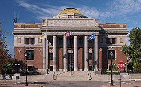 Stearns County Courthouse, 2013.
 Cathedral of Saint Mary (St. Cloud, Minnesota), 2013.
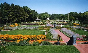 Munsinger and Clemens Gardens, 1997.

 Great River Regional Library GRRL, 2020
 First National Bank, 2013.
 Michael Majerus House (now Victorian Oaks Bed & Breakfast), 2016


Sports
The city is home to:
- the St. Cloud State University Division I ice hockey teams. Men's Husky Hockey competes in the National Collegiate Hockey Conference. Women's Husky Hockey competes in the Western Collegiate Hockey Association. The men's team has made nine NCAA Men's Ice Hockey Championship appearances, notably advancing to the 2013 Frozen Four in Pittsburgh, Penn.[40] The 2012-13 team's co-captain and fifth-year forward, Drew LeBlanc, was named WCHA Player of the Year and earned numerous national honors, including the Hobey Baker Award, the most prestigious award in men's college hockey.[41] The 2013 team also earned a share of the WCHA league title and its symbol, the century-old MacNaughton Cup.[42] The Huskies play in the 5,763-seat Herb Brooks National Hockey Center, which underwent a $18 million renovation and expansion in 2012–13.[43]
- the St. Cloud Norsemen, a Tier II junior hockey team at the Municipal Athletic Complex.
- the Granite City Lumberjacks, a Tier III junior hockey team in nearby Sauk Rapids.
- the St. Cloud Rox (formerly the River Bats) of the Northwoods League, a collegiate summer baseball league. The Rox play at Joe Faber Field in St. Cloud and were founded in 2012.
- the Saint Cloud Area Roller Dolls, a flat-track roller derby league founded in 2011.[44]
- the Saint Cloud River Runners club, who put on the Lake Wobegon Trail Marathon, an annual event in central Minnesota. The race is used as a Boston-qualifying event for runners who want a straight, quiet, scenic, mostly flat route in the early spring.[45]
- the Granite City FC is a minor league soccer team founded in 2016. It currently plays in the United Premier Soccer League (UPSL).
Parks and recreation
The city maintains 95 parks, totaling more than 1,400 acres (5.7 km2) and ranging in size from 80 acres (0.32 km2) "neighborhood and mini parks" to 243 acres (0.98 km2). The largest developed park, Whitney Memorial Park, is the former location of the city airport. It features a recreation center for senior citizens, a dog park, and numerous softball, baseball, and soccer fields.
Government
Since 2005, St. Cloud's mayor has been Dave Kleis. He was reelected to a fifth term in 2020.
St. Cloud has been moved by Congressional redistricting to a wide variety of Minnesota regions, including northern, south central, northwest and southwest. In Congressional district maps in effect since 2003, it has been grouped with rural areas and suburbs north and west of the Twin Cities.[46] The district had only minor changes in a 2022 map drawn by a five-judge panel based on the 2020 census.[47][48] St. Cloud is the largest city in Minnesota's 6th congressional district, represented by Republican Tom Emmer.
The city makes up the majority of population of Minnesota State Senate District 14, which straddles the Mississippi River and includes parts of three counties,[49][50] represented by Aric Putnam. Minnesota House District 14A includes generally western parts of the city as well as Waite Park, St. Augusta and adjacent rural areas,[51] represented by Dan Wolgamott. District 14B includes east central and northeast St. Cloud, neighboring Sauk Rapids and parts of rural Benton and Sherburne Counties,[52] represented by Tama Theis.
In 2016, St. Cloud converted from 5% to 80% renewable energy by using solar gardens, street light improvements, bio-gas, and other energy efficiency initiatives.[53][54] St. Cloud's wastewater plant converts sugar-laden liquids from local food and beer manufacturers into fuel and fertilizer. Since 2020, the city has produced more energy than it consumes.[55]
Past mayors of St. Cloud include:
- Sylvanus B. Lowry (1856), selected by town council members as council president (office of mayor did not yet exist)
- John L. Wilson (1857–1858)
- E. O. Hamlin (1868)
- J. A. McDonald (1900)
- J. R. Boyd (1901)
- J. E. C. Robinson (1902–1905 and 1906)
- J. N. Bensen (1905)
- David McCarty (1907)
- Louis Brown (1907)
- Hugh Evans (1908–1909)
- D. H. Freeman (1910 and 1916–1919)
- P. J. Seberger (1911–1912)
- H. J. Limperich (1919)
- W. W. Matson (1920–1924). 19th Amendment gives women the right to vote.
- J. Arthur Bensen (1924–1928)
- James H. Murphy (1928–1932, 1945–1948)
- Phil Collignon (1932–1945)
- Mathew Malisheski (1948–1952)
- Lawrence A. Borgert (1952). City Charter revised, creating current "standard mayor form" of government.[56]
- George Byers (1953–1960)
- Thomas E. Mealey (1960–1964)
- Ed Henry (1964–1971)
- Al Loehr (1971–1980)
- Sam Huston (1980–1989)
- Chuck Winkelman (1989–1997)
- Larry Meyer (1997–2001)
- John Ellenbecker (2001–2005)
Politics
President Joe Biden and Vice President Kamala Harris won St. Cloud's votes in the 2020 presidential election by a margin of 9%, higher than the state margin of 7.12%. In 2016, former President Donald Trump won St. Cloud by 1.75% over Democratic nominee Hillary Clinton.[57]
| Year | Republican | Democratic | Third parties |
|---|---|---|---|
| 2020 | 43.9% 14,209 | 52.9% 17,149 | 3.2% 1,036 |
| 2016 | 45.7% 14,401 | 44.0% 13,850 | 10.3% 3,254 |
| 2012 | 44.5% 14,295 | 52.3% 16,835 | 3.2% 1,032 |
| 2008 | 43.9% 14,505 | 53.6% 17,688 | 2.5% 839 |
| 2004 | 46.9% 14,909 | 51.5% 16,394 | 1.6% 506 |
| 2000 | 43.9% 11,647 | 45.0% 11,958 | 11.1% 2,941 |
| 1996 | 38.0% 8,565 | 49.6% 11,169 | 12.4% 2,783 |
| 1992 | 34.9% 9,527 | 41.5% 11,331 | 23.6% 6,422 |
| 1988 | 46.1% 9,251 | 53.9% 10,823 | 0.0% 0 |
| 1984 | 51.0% 10,598 | 49.0% 10,189 | 0.0% 0 |
| 1980 | 42.4% 8,702 | 46.3% 9,487 | 11.3% 2,236 |
| 1976 | 40.1% 8,045 | 55.7% 11,176 | 4.2% 845 |
| 1972 | 43.0% 6,512 | 52.7% 7,970 | 4.3% 646 |
| 1968 | 40.6% 5,389 | 55.5% 7,378 | 3.9% 515 |
| 1964 | 36.4% 4,872 | 63.1% 8,439 | 0.5% 66 |
| 1960 | 41.5% 5,391 | 58.4% 7,589 | 0.1% 8 |
Education
Primary home languages of St. Cloud Public School students[59]
Almost all of St. Cloud, including the portions in Stearns and Sherburne Counties,[60][61] and much the portion in Benton County, is in the St. Cloud Public School District. A portion of Benton County St. Cloud is in the Sauk Rapids-Rice Public Schools district.[62]
The St. Cloud Area School District serves St. Cloud, St. Augusta, Clearwater, Waite Park, St. Joseph, Haven Township, and parts of Sauk Rapids.[citation needed] It has eight elementary schools, a new K-8 school in St. Joseph, and two major public high schools, St. Cloud Technical High School and St. Cloud Apollo High School.[63] St. Cloud also has a major private high school, Cathedral High School. Both public high schools offer a broad selection of Advanced Placement courses and rank high in the state in the number of AP tests taken and of test takers.[64] St. Cloud Tech opened in 1917 across from a city park and Lake George. In 2019, it moved to a new 69-acre, $104 million facility on the southwest edge of the city. The historic 1917 building has been acquired for use by city government. Apollo opened in 1970 and serves the expanding north side of the city. Other high schools and secondary schools that serve St. Cloud include St. Robert Bellarmine's Academy, St. Cloud Christian School, Immaculate Conception Academy, St. John's Preparatory School, St. Cloud Alternative Learning Center, and the charter school STRIDE Academy,[65] which is K-8. The nearby cities of Sauk Rapids and Sartell also have their own school districts and high schools, bringing the number of public high schools in the metropolitan area to four.[citation needed]
Colleges
St. Cloud is home to several higher education institutions, including Minnesota's third-largest university, St. Cloud State University. St. Cloud State's fall 2020 enrollment was 12,607, in a year affected by the COVID-19 pandemic.[66]
St. Cloud's other post-secondary institutions and campuses include St. Cloud Technical and Community College (SCTCC) and Rasmussen College. Neighboring Sartell is home to a campus of the Duluth-based College of St. Scholastica, and the College of St. Benedict and St. John's University are in neighboring St. Joseph and nearby Collegeville, respectively.[67]
Media
The main newspaper is the St. Cloud Times, a Gannett daily newspaper.
St. Cloud is part of the Twin Cities television market. One full-power station, the Ion-owned KPXM-TV (channel 41), is licensed to the city, but moved its transmitter to the Twin Cities in 2009 as part of the digital transition, and maintains no presence in the city. WCMN-LD (channel 13) is a low-power station licensed to St. Cloud that broadcasts in ATSC 3.0. Additionally, St. Cloud State University students operate cable-only UTVS (channel 180), which includes local news and broadcasts from a studio on campus.[68]
Radio stations include:
FM
| FM radio stations | ||||
|---|---|---|---|---|
| Frequency | Call sign | Name | Format | Owner |
| 88.1 88.1 HD-2 | KVSC | Radio X | College Radio Alternative Rock | St. Cloud State University |
| 88.9 88.9 HD-2 | KNSR | MPR News 89.3 The Current | Public Radio Adult Album Alternative | Minnesota Public Radio |
| 89.5 | K208DV (KLRD-FM Translator) | Air 1 | Contemporary Christian | Educational Media Foundation |
| 90.1 | KSJR | Classical MPR | Classical | Minnesota Public Radio |
| 91.5 | KCFB (KTIG-FM Simulcast) | Christian | Minnesota Christian Broadcasters | |
| 92.9 | KKJM | Spirit 92.9 | Contemporary Christian | Gabriel Media |
| 93.5 | K228FV (KYES-AM Translator) | Relevant Radio | Catholic | |
| 93.9 | W230DG (KXSS-AM Translator) | 1390 Granite City Sports | Sports | Townsquare Media |
| 94.3 | K232GA (WXYG-AM Translator) | Album Rock 540 | Classic rock | Tri-County Broadcasting |
| 94.9 | KMXK | Mix 94.9 | Adult Contemporary | Townsquare Media |
| 95.3 | W237EU (WJON-AM Translator) | News/Talk | ||
| 95.7 | W239CU (WBHR-AM Translator) | The Bear | Sports | Tri-County Broadcasting |
| 96.1 | WROJ (LPFM) | The Rock FM | Contemporary Christian | The Rock FM Communications, Inc. |
| 96.7 | KZRV | The River | Classic Hits | Townsquare Media |
| 97.5 | KVEX (LPFM) | RadioX | Alternative Rock | St. Cloud State University |
| 98.1 | WWJO | 98-1 Minnesota's New Country | Country | Townsquare Media |
| 98.9 98.9 HD-2 98.9 HD-3 | KZPK | Wild Country 99 KNSI Z-Rock 103.3 | Country News/Talk Classic Rock | Leighton Broadcasting |
| 99.3 | K257GK (KNSI-AM Translator) | KNSI | News/Talk | |
| 99.9 | KCML | 99.9 Lite FM | Adult Contemporary | |
| 101.1 | W266DT (WMIN-AM Translator) | Uptown 1010 | Adult Standards | Tri-County Broadcasting |
| 101.7 101.7 HD-2 101.7 HD-3 101.7 HD-4 | WHMH | Rockin' 101 Album Rock 540 106.5 The Point Uptown 1010 | Active Rock Classic rock Alternative Adult Standards | |
| 102.3 | W232EG (WVAL-AM Translator) | Classic Country | ||
| 103.3 | K277BS (KZPK HD-3 Translator) | Z-Rock 103.3 | Classic rock | Leighton Broadcasting |
| 103.7 | KLZZ | The Loon | Classic rock | Townsquare Media |
| 104.7 | KCLD | Top 40 | Leighton Broadcasting | |
| 105.1 | KZYS (LPFM) | Somalian | Saint Cloud Area Somali Salvation Organization | |
| 106.5 | W293CS (WHMH HD-3 Translator) | 106.5 The Point | Alternative | Tri-County Broadcasting |
| 107.3 | W297BO (WXYG-AM Translator) | Album Rock 540 | Classic rock | |
AM
| AM radio stations | ||||
|---|---|---|---|---|
| Frequency | Call sign | Name | Format | Owner |
| 540 AM | WXYG | The Goat | Classic rock | Tri-County Broadcasting |
| 660 AM | WBHR | The Bear | Sports | |
| 800 AM | WVAL | Classic Country | ||
| 1010 AM | WMIN | Uptown 1010 | Adult Standards | |
| 1180 AM | KYES | Relevant Radio | Catholic | Gabriel Media |
| 1240 AM | WJON | News/Talk | Townsquare Media | |
| 1390 AM | KXSS | 1390 Granite City Sports | Sports | |
| 1450 AM | KNSI | News/Talk | Leighton Broadcasting | |
Infrastructure
Transportation
St. Cloud is a regional transportation hub within Minnesota. Major roadways including Interstate Highway 94, U.S. Highway 10, and Minnesota State Highways 15 and 23 pass through the city.[69]
Bus service within the city and to neighboring Sartell, Sauk Rapids, and Waite Park is offered through St. Cloud Metro Bus, which was recognized in 2007 as the best transit system of its size in North America. An innovative system gives transit buses a slight advantage at stoplights in order to improve efficiency and on-time performance.[70] The Metro Bus Transit Center in the downtown area is also shared with Jefferson Lines, providing national bus service.
Bus service links downtown St. Cloud and St. Cloud State University with the western terminus of the Northstar Commuter Rail line in Big Lake, by the way of Northstar Link Commuter Bus, which in turn links to the Metro Transit bus and light rail system at Target Field Station in downtown Minneapolis.
Several rail lines run through the city, which is a stop on Amtrak's Empire Builder passenger rail line.
St. Cloud is home to St. Cloud Regional Airport, from which daily connecting flights to Minneapolis–Saint Paul International Airport were made on Delta Connection, operated by Mesaba Airlines, until January 1, 2010, when the service was discontinued. On December 15, 2012, Allegiant Air began nonstop flights between St. Cloud Regional Airport and Phoenix-Mesa Gateway Airport, on McDonnell Douglas MD-80 aircraft.[71]
Major highways
 Interstate 94
 U.S. Highway 10
 Minnesota State Highway 15
 Minnesota State Highway 23
Notable people
- Halima Aden, model and first Somali-American to compete for Miss Minnesota; worked alongside Gigi Hadid, and modeled for Kanye West's fashion brand Yeezy Season 5
- Mathew Ahmann, civil rights activist
- Raymond H. Bares, Minnesota state senator and educator
- Tom Burgmeier, Major League Baseball player; grew up in St. Cloud and attended Cathedral High School[72]
- Loren W. Collins, Minnesota jurist and legislator; mayor of St. Cloud
- David Durenberger, former United States Senator from Minnesota
- Jim Eisenreich, Major League Baseball player for 1997 World Series champion Florida Marlins
- Janice Ettle, five-time competitor at the woman's US Olympic Marathon Trials, two-time winner of Grandma's Marathon and winner of the 1985 Twin Cities Marathon
- Howard M. Fish, retired U.S. Air Force lieutenant general, former assistant vice chief of staff of Air Force
- Charles A. Gilman, ninth Lieutenant Governor of Minnesota
- Janey Gohl, 1978 Miss Minnesota USA
- Lawrence M. Hall, longest-serving Speaker of the Minnesota House of Representatives
- Keith F. Hughes, Minnesota state senator and lawyer
- Jack I. Kleinbaum, businessman, St. Cloud City Council member, and Minnesota state legislator
- Dave Kleis, mayor of St. Cloud
- Jim Knoblach, Republican member of the Minnesota House of Representatives
- Franklin J. Knoll, Minnesota state legislator, lawyer, and judge
- June Marlowe, actress notable for playing Miss Crabtree in short-film series Our Gang
- John McMartin, film, television and stage actor
- Stephen Miller, abolitionist, Civil War veteran, Republican politician, fourth Governor of Minnesota
- Edgar G. Mills, Wisconsin State Assemblyman and Senator
- William P. Murphy, former Associate Justice of Minnesota Supreme Court
- Jim Pehler, Minnesota state legislator
- Tom Petters, former CEO and chairman of Petters Group Worldwide,[73] convicted for involvement in a $3.65 billion Ponzi scheme[74]
- Reynold Philipsek, gypsy jazz guitarist
- Dewey H. Reed, educator and politician
- Alise Willoughby, BMX racer and Olympic silver medalist.[75]
- Michael Sauer, professional ice hockey player for New York Rangers
- Anne Schleper, women's hockey Olympic silver medalist, 2014[76]
- Nate Schmidt, professional ice hockey player for NHL's Vegas Golden Knights, Washington Capitals, Winnipeg Jets
- Stephen Sommers, film director and alumnus of Cathedral High School and St. John's University
- Charles Thomas Stearns, politician
- Jane Swisshelm, newspaper owner, editor and abolitionist
- Craig Thomas, television writer and producer, co-creator of How I Met Your Mother
- Gene Waldorf, electrical engineer and politician
- Nate Wolters, professional basketball player
- Gig Young, Academy Award-winning actor, film and television star; born in St. Cloud
Sister cities
In popular culture
- Season 3 of FX's Fargo depicts St. Cloud as the residence of both Ray Stussy (Ewan McGregor) and Nikki Swango (Mary Elizabeth Winstead), but was not filmed there.
- Courtroom scenes in the Disney Film The Mighty Ducks were filmed in St. Cloud, and a few scenes were filmed at the Municipal Athletic Complex (MAC) but did not make the final film.
- Al Franken and Tom Davis's One More Saturday Night is set in St. Cloud, but was not filmed there.
- Juno was partially set in St. Cloud, which is referred to as "East Jesus Nowhere", though no filming took place in the city.
- The song "On a Bus to St. Cloud", by Gretchen Peters, is on Trisha Yearwood's 1995 album Thinkin' About You.
- In 2005, Penn & Teller: Bullshit! shot an episode on the SCSU campus.
- In the 2007 horror movie 1408, St. Cloud is mentioned as one of the scariest places the protagonist has visited while investigating haunted houses.
- Judith Guest and Rebecca Hill's novel Killing Time in St. Cloud is set in the eponymous city.
- John Bellairs's character Mr. Emerson is from St. Cloud.
- In the novel The Death and Life of Charlie St. Cloud by Ben Sherwood, the main character's mother grew up in the city.
- In the sitcom How I Met Your Mother, Marshall Eriksen is from St. Cloud. Throughout the series, St. Cloud is visited by several characters several times, but is portrayed as a much smaller town than it is in reality.
- The 1989 film Catch Me If You Can was shot in St. Cloud[77]
- In the 1990 children's book, Blumpoe the Grumpoe Meets Arnold the Cat, protagonist Horace P. Blumpoe's sister Edith lives in St. Cloud, and Horace visits her every year in November.
See also
- 1998 St. Cloud explosion
- Dave Torrey Arena
References
- Dominik, John J. (1986). That You May Find Healing. St. Cloud, Minn: St. Cloud Hospital. p. 5.
- "2020 U.S. Gazetteer Files". United States Census Bureau. Retrieved July 24, 2022.
- "US Board on Geographic Names". United States Geological Survey. October 25, 2007. Archived from the original on February 12, 2012. Retrieved January 31, 2008.
- "Explore Census Data". United States Census Bureau. Retrieved May 9, 2022.
- "City and Town Population Totals: 2020-2021". United States Census Bureau. June 16, 2022. Retrieved June 19, 2022.
- "Find a County". National Association of Counties. Archived from the original on June 26, 2015. Retrieved June 7, 2011.
- "Area Definitions - Metropolitan Statistical Areas". Minnesota Department of Employment and Economic Development. Archived from the original on February 13, 2009. Retrieved October 3, 2009.
- Metro Council website, Twin Cities Metropolitan Area Geographic Definitions, "Definitions Used By The U.S. Census Bureau" Archived April 11, 2008, at the Wayback Machine
- Minnesota Department of Natural Resources, "Mississippi River", "St. Cloud to Anoka" Archived April 3, 2008, at the Wayback Machine
- "The Wild & Scenic Mississippi River". Minnesota Department of Natural Resources. Archived from the original on September 19, 2009. Retrieved October 3, 2009.
- City of St. Cloud, Public Utilities,
- Minnesota Department of Natural Resources (DNR) "Operating Hydropower Sites In Minnesota"
- John Weeks, John Weeks, The Bridges and Structures of the Mississippi River Headwaters Archived October 15, 2007, at the Wayback Machine, A Detailed Look At The Bridges, Dams And Other Structures On The Mississippi River In The Headwaters Region From Lake Itasca To Minneapolis, November 2007.
- Kevin Knight. "Diocese of Saint Cloud". New Advent. Archived from the original on August 19, 2013. Retrieved April 5, 2013.
- "3 Towns Into 1 City, A Narrative Record of Significant Factors in The Story Of St. Cloud Minnesota."
- St. Cloud City website Document Center
- "Sylvanus Lowry" Archived June 2, 2013, at the Wayback Machine, Minnesota Legislators Past and Present, accessed July 4, 2012
- https://www.ci.stcloud.mn.us/DocumentCenter/View/685/Newly-Elected-Orientation?bidId= Newly Elected Orientation, section (9) History of the City
- Ambar Espinoza, "St. Cloud professor unearths history of slavery in Minnesota" Archived June 13, 2012, at the Wayback Machine, Minnesota Public Radio, May 7, 2010, accessed July 4, 2012
- Our Gohman Story: The First and Second Generations ISBN 978-1-5049-0520-6 p. 173
- John J. Dominik Jr., "Three Towns Into One City," St. Cloud, Minnesota: St Cloud Area Bicentennial Commission, 1976, p. 13
- "Pan History". St Cloud Antique Auto Club, Inc. January 1, 2007. Archived from the original on July 1, 2007. Retrieved June 20, 2007.
- "Automotive History Online, Pan Motor". Automotivehistoryonline.com. Archived from the original on September 29, 2011. Retrieved November 6, 2011.
- "US Gazetteer files 2010". United States Census Bureau. Archived from the original on January 12, 2012. Retrieved November 13, 2012.
- | LakeFinder , Minnesota Department of Natural Resources.
- Malakowsky, "Minnesota adds 305 streams and lakes to its impaired waters list, including new PFAS water in Greater Minnesota", Minnesota Pollution Control Agency November 8, 2021
- Richard W. Ojakangas, Roadside Geology of Minnesota, 2009, glacial history of Minnesota page 26, "Glacial geology of central Minnesota - modified from Hobbs and Goebel,1982, page 196, granite dating page 204
- "NowData – NOAA Online Weather Data". National Oceanic and Atmospheric Administration. Retrieved June 24, 2021.
- Mean monthly maxima and minima (i.e. the expected highest and lowest temperature readings at any point during the year or given month) calculated based on data at said location from 1991 to 2020.
- "Station: St Cloud RGNL AP, MN". U.S. Climate Normals 2020: U.S. Monthly Climate Normals (1991-2020). National Oceanic and Atmospheric Administration. Retrieved June 24, 2021.
- United States Census Bureau. "Census of Population and Housing". Archived from the original on April 26, 2015. Retrieved June 15, 2013.
- United States Census Bureau, QuickFacts, St. Cloud city, Minnesota
- "St Cloud city, Minnesota". Profile of General Population and Housing Characteristics: 2010; 2010 Demographic Profile Data. United States Census Bureau. Archived from the original on December 27, 1996. Retrieved December 8, 2012.
- U.S. Bureau of Labor Statistics May 2020 Metropolitan and Nonmetropolitan Area Occupational Employment and Wage Estimates St. Cloud, MN
- Archived December 24, 2016, at the Wayback Machine|Comprehensive Annual Financial Reports (CAFR)
- "St. Cloud snags 4 awards at international competition for most livable cities" Jenny Berg, St. Cloud Times, 12/13/2019]
- "Archived copy" (PDF). Archived from the original (PDF) on July 16, 2011. Retrieved July 19, 2009.
{{cite web}}: CS1 maint: archived copy as title (link) - Park Nature Preserve, Stearns County Parks
- "Archived copy" (PDF). Archived (PDF) from the original on April 2, 2015. Retrieved April 1, 2015.
{{cite web}}: CS1 maint: archived copy as title (link) - "Tag Archives: FrozenFour". St. Cloud State University. Archived from the original on November 3, 2013. Retrieved June 14, 2013.
- "Hobey Baker Memorial Award". Hobey Baker Memorial Award Foundation. Archived from the original on July 7, 2013. Retrieved June 14, 2013.
- "Men's hockey: Top seed, title". St. Cloud State University. Archived from the original on April 10, 2013. Retrieved March 14, 2013.
- "Brooks Center: It can happen here". St. Cloud State University. Archived from the original on June 27, 2014. Retrieved October 15, 2013.
- "Saint Cloud Area Roller Dolls". Saint Cloud Area Roller Dolls. Archived from the original on February 9, 2013. Retrieved September 18, 2012.
- "Lake Wobegon Trail Marathon". Lake Wobegon Trail Marathon. St. Cloud River Runners. Archived from the original on April 6, 2019. Retrieved April 1, 2019.
- Minnesota's congressional districts
- |"Looking for Census 2020 data? Here is what you need to know" Minnesota State Demographic Center
- Tim Pugmire, MInnesota Public Radio, "New political district maps shake up Minnesota politics", February 22, 2022
- |MN Secretary of State Election Administration
- |MN Secretary of State Legislative Maps Senate District 14 map
- |MN Secretary of State Legislative Maps Senate District 14A map
- |MN Secretary of State Legislative Maps Senate District 14B map
- "St. Cloud will be powered by 80% renewable energy by 2018" Archived September 26, 2019, at the Wayback Machine, Clean Energy Resource Teams (CERTs), retrieved 9/7/2019.
- "City of St. Cloud Minnesota, The Path to Energy Neutral", Patrick Shea, Public Services Director, Tracy Hodel, Assistant Public Utilities Director.
- Jenny Berg, Innovation at wastewater plant propels St. Cloud to renewable energy leader, Start Tribune, May 21, 2022
- https://www.ci.stcloud.mn.us/DocumentCenter/View/685/Newly-Elected-Orientation?bidId= Newly Elected Orientation, Section "2) Form of Government"
- |"Which St. Cloud suburb went for Democrat Joe Biden? And other election take-aways", Nora Hertel, Government Watchdog Report, St Cloud Times, 11/14/2020
- "Office of the Minnesota Secretary of State - Election Results". Archived from the original on February 22, 2021. Retrieved February 22, 2021.
- "Data Reports and Analytics". Minnesota Department of Education. Retrieved September 4, 2022.
- "2020 CENSUS - SCHOOL DISTRICT REFERENCE MAP: Stearns County, MN" (PDF). U.S. Census Bureau. Retrieved November 7, 2022.
- "2020 CENSUS - SCHOOL DISTRICT REFERENCE MAP: Sherburne County, MN" (PDF). U.S. Census Bureau. Retrieved November 7, 2022.
- "2020 CENSUS - SCHOOL DISTRICT REFERENCE MAP: Benton County, MN" (PDF). U.S. Census Bureau. Retrieved November 7, 2022.
- "St. Cloud Area School District 742". Isd742.org. September 1, 2011. Archived from the original on November 7, 2011. Retrieved November 6, 2011.
- "AP Exams by School". Ohe.state.mn.us. Archived from the original on March 10, 2007. Retrieved November 6, 2011.
- "Home". Stride Academy. Archived from the original on November 1, 2011. Retrieved November 6, 2011.
- | Nora G. Hertel, "A How has COVID-19 has changed higher ed enrollment in St. Cloud?", St. Cloud Times, December 26, 2020.
- "College of Saint Benedict Saint John's University". csbsju.edu. Archived from the original on March 30, 2015. Retrieved March 29, 2015.
- "About". UTVS.com. Archived from the original on April 13, 2017. Retrieved April 13, 2017.
- "St. Cloud, Minnesota". Google Maps. Archived from the original on December 13, 2011. Retrieved May 19, 2007.
- WCCO News, "System Helps St. Cloud Buses Stay In The Green" Archived July 30, 2010, at the Wayback Machine, July 17, 2009.
- "St. Cloud Airport Website". St. Cloud Airport. Archived from the original on June 20, 2010. Retrieved May 21, 2010.
- "Tom Burgmeier at SABR Baseball Biography Project". Archived from the original on April 8, 2014. Retrieved April 8, 2014.
- Nicole Muehlhausen, BIO: Tom Petters Archived October 11, 2008, at the Wayback Machine, KSTP.com, September 24, 2008, Accessed October 8, 2008,
- Hughes, Art (December 2, 2009). "UPDATE 2-Tom Petters found guilty of Ponzi scheme fraud". Reuters. Thomson Reuters. Archived from the original on December 9, 2009. Retrieved December 10, 2009.
- Maurice, Jim (September 2, 2016). "St. Cloud To Honor Alise Post With A Parade". WJON. Archived from the original on September 4, 2016. Retrieved March 11, 2017.
- | "Olympian Anne Schleper Retires", USA Hockey 2/15/17
- "Catch Me If You Can". Archived from the original on December 15, 2016. Retrieved October 25, 2016 – via www.imdb.com.
External links
 Definitions from Wiktionary
 Media from Commons
 News from Wikinews
 Quotations from Wikiquote
 Texts from Wikisource
 Textbooks from Wikibooks
 Travel information from Wikivoyage
 Resources from Wikiversity
 Data from Wikidata
Places adjacent to St. Cloud, Minnesota | ||||||||||||||||
|---|---|---|---|---|---|---|---|---|---|---|---|---|---|---|---|---|
| ||||||||||||||||
Municipalities and communities of Benton County, Minnesota, United States | ||
|---|---|---|
County seat: Foley | ||
| Cities |  | |
| Townships | ||
| CDP | ||
| Unincorporated communities | ||
| Footnotes | ‡This populated place also has portions in an adjacent county or counties | |
| ||
Municipalities and communities of Sherburne County, Minnesota, United States | ||
|---|---|---|
County seat: Elk River | ||
| Cities |  | |
| Townships | ||
| Unincorporated communities | ||
| Footnotes | ‡This populated place also has portions in an adjacent county or counties | |
| ||
Municipalities and communities of Stearns County, Minnesota, United States | ||
|---|---|---|
County seat: St. Cloud | ||
| Cities |
|  |
| Townships |
| |
| CDPs | ||
| Unincorporated communities | ||
| Footnotes | ‡This populated place also has portions in an adjacent county or counties | |
| ||
| Core City |  | ||||
|---|---|---|---|---|---|
| Surrounding communities |
| ||||
| Counties | |||||
‡ indicates that it is partially in the metropolitan area. § indicates a CDP | |||||
Authority control | |
|---|---|
| General | |
| National libraries | |
| Other |
|
На других языках
[de] St. Cloud (Minnesota)
St. Cloud [.mw-parser-output .IPA a{text-decoration:none}ˌseɪntˈklaʊd] ist eine Stadt (mit dem Status „City“) und Verwaltungssitz des Stearns County im Zentrum des US-amerikanischen Bundesstaates Minnesota. Die Stadt erstreckt sich auch in das Benton und das Sherburne County. Im Jahr 2020 hatte St. Cloud 68.881 Einwohner.[1]- [en] St. Cloud, Minnesota
[es] St. Cloud (Minnesota)
St. Cloud es una ciudad del estado estadounidense de Minnesota y el centro de población más grande de la región central del estado. Su población es de 68,462 según las estimaciones del censo de Estados Unidos de 2019, lo que la convierte en la décima ciudad más grande de Minnesota.[2] St. Cloud es la sede del condado de Stearns[3] y recibió su nombre de la ciudad de Saint-Cloud, Francia (en Île-de-France, cerca de París), que recibió su nombre del monje francés del siglo VI Clodoaldo.[ru] Сент-Клауд (Миннесота)
Се́нт-Кла́уд (англ. Saint Cloud, дословно — «Святой Клод»; МФА: [seɪntˈklaʊd]) — город в штате Миннесота, США. Население — 61 198 чел. (по переписи 2010 года)[1]. Город расположен на территории сразу трёх округов — Стернса, Бентона и Шерберна. Мэр — Дэйв Кляйс (англ.) (рус.[2]. Назван в честь французского города Сен-Клу, носящего имя святого Kлодоальда. FIPS-код города — 27-56896[3], GNIS-идентификатор — 0650559[4].Другой контент может иметь иную лицензию. Перед использованием материалов сайта WikiSort.org внимательно изучите правила лицензирования конкретных элементов наполнения сайта.
WikiSort.org - проект по пересортировке и дополнению контента Википедии